|
GCOOS is the Gulf of Mexico regional component of the U.S. Integrated Ocean Observing System (IOOS). Our mission is to provide timely, reliable and accurate information on the open and coastal ocean waters of the Gulf of Mexico to ensure a healthy, clean, productive ocean and resilient coastal zone.
|
|
|
|
August 2017 - In This Issue:
|
|
|
|
|
|
Nadine Slimak, Public Relations & Content Marketing, Vetted Communications, LLC
|
|
|
New Funding for HFR in the Gulf 
|
GCOOS is pleased to announce that it has received $450,000 to support the installation of two new High Frequency Radar (HFR) sites near the mouth of the Mississippi River through our annual funding award from the U.S.  Integrated Ocean Observing System. Integrated Ocean Observing System.
"Our coasts and citizens are vulnerable to many different risks," said Dr. Barbara Kirkpatrick, Executive Director. "Having HFR in place means the difference between finding someone lost at sea or telling us where oil or other chemicals from a spill are likely to wash up so we can be ready for them. We have a critical shortage of HFR sites in the Gulf so funding like this, provided through the U.S. IOOS office, is absolutely critical for expanding our coverage area and saving lives. It's as simple as that."
GCOOS has released a request for proposals [LINK TO LOI] for the installation of these two new HFR sites that will provide surface current mapping coverage to support oil spill response needs, navigation and commerce near the approach to the mouth of the Mississippi - one of the busiest shipping byways in the world.
Letters of Intent are due by close of business Sept. 6.
|
|
|
Register now to attend the GCOOS fall meeting taking place from 8:30 a.m. to 5 p.m. (CDT) Oct. 12 in Mobile, Alabama. The agenda includes key updates from GCOOS  and our state partners, along with subcontractor reports in the afternoon. (Early draft agenda) Non-members also welcome! and our state partners, along with subcontractor reports in the afternoon. (Early draft agenda) Non-members also welcome!
(Note: The Members Meeting coincides with closed sessions of the GCOOS Board of Directors, which take place on Oct. 11 and 13.)
The Members Meeting will be at the NOAA Disaster Response Center, 7344 Zeigler Blvd., Mobile, Alabama, 33608. Light breakfast and lunch are provided by GCOOS, but please use our Google form to register your attendance so we may plan accordingly.
- Questions? Please contact GCOOS Research Associate Jen Vreeland.
|
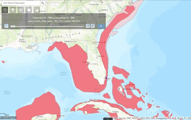
Dispatches from the Gulf recently featured Will Patterson of Dauphin Island Sea Lab and his study of invasive lionfish in the Gulf. Lionfish were introduced off the
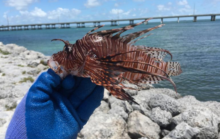 coast of Florida in the late 1980s. Throughout their invaded range, the fish have had dramatic effects on native fish populations.
Did you know that GCOOS has an app tracking the invasion?
Working with The Nature Conservancy, GCOOS Product Developer Dr. Shin Kobara, created an app that tracks reports of lionfish populations and their invasion in the Gulf of Mexico and the wider Caribbean Sea using information from more than a dozen data sources, including the U.S. Geological Survey. The time slider on the app shows the explosive growth of lionfish populations over time. It also allows viewers to look at individual lionfish reports and includes a predicted distribution area.
|
|
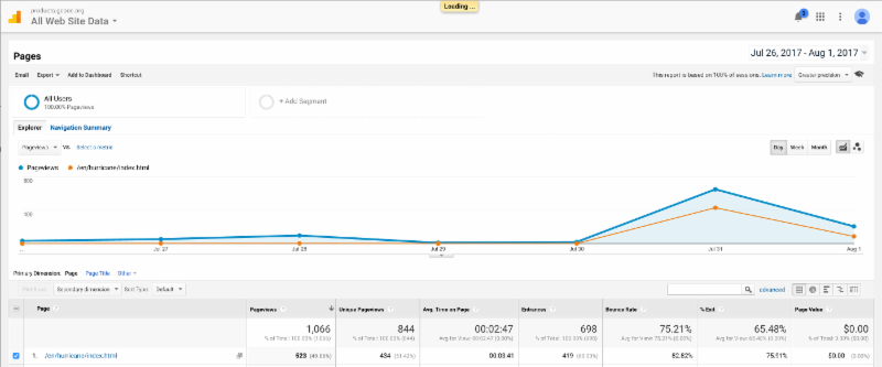
GCOOS Hurricane Pages Draw Visitors
|
|
The GCOOS website - and particularly our new hurricane pages - saw a spike in traffic as Tropical Storm Emily made landfall in Florida at the end of July. GCOOS product developers created the page focused on tropical weather affecting the Gulf of Mexico earlier this summer and it includes:
- Maps with predicted storm tracks, weather forecasts, live web cams along the Gulf coast and more;
- The National Hurricane Center (NHC) weather outlook;
- NOAA satellite loops;
- A Twitter feed with the latest hurricane/tropical weather news from sources like the NHC, National Weather Service (NWS), the Federal Emergency Management Agency (FEMA), the Weather Channel and others;
- Links to Gulf state emergency management centers;
- Links to county evacuation and shelter information;
- Plus videos on storm preparation, what to do during a storm and what to do after a storm.
|
The Louisiana Science Teachers Association has joined GCOOS as our newest member! LSTA is the state chapter of the National Science Teachers Association with a  membership of about 1,400 formal and informal science educators. The organization is dedicated to the advancement of scientific literacy at all levels. LSTA provides members with current information on science education, upcoming science education professional development workshops, science education grant and award opportunities, science teacher trainings as well as an annual professional development conference. Special thanks go to Jean May-Brett, GCOOS Board Member, for helping to facilitate this important new relationship. membership of about 1,400 formal and informal science educators. The organization is dedicated to the advancement of scientific literacy at all levels. LSTA provides members with current information on science education, upcoming science education professional development workshops, science education grant and award opportunities, science teacher trainings as well as an annual professional development conference. Special thanks go to Jean May-Brett, GCOOS Board Member, for helping to facilitate this important new relationship.
|
|
Call for Glider Session Submissions at Ocean Sciences
|
The call for abstract submissions is now open for next year's Ocean Sciences Meeting in February, which will include a session on gliders.
Co-sponsored by the American Geophysical Union (AGU), the 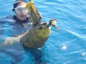 Association for the Sciences of Limnology and Oceanography (ASLO) and The Oceanography Society, the Ocean Sciences Meeting will span a broad array of marine science topics. GCOOS Executive Director Dr. Barbara Kirkpatrick and her Co-Chair of the IOOC's Glider Task Team, Becky
Baltes from the IOOS Program office
, will be leading the session "Increasing Success of Underwater Glider Missions" in the topic area "Ocean Observatories, Instrumentation and Sensing Technologies." Association for the Sciences of Limnology and Oceanography (ASLO) and The Oceanography Society, the Ocean Sciences Meeting will span a broad array of marine science topics. GCOOS Executive Director Dr. Barbara Kirkpatrick and her Co-Chair of the IOOC's Glider Task Team, Becky
Baltes from the IOOS Program office
, will be leading the session "Increasing Success of Underwater Glider Missions" in the topic area "Ocean Observatories, Instrumentation and Sensing Technologies."
Underwater glider technologies and applications are advancing and the ocean observing community is examining means to encourage greater collaboration with decision-makers, glider operators and data users. The session is intended to allow glider operators and data managers to present information on how they are improving overall successes of glider missions within the areas of ocean monitoring, operational reliability, data management and interagency and international coordination.
The call for abstract submissions is open through Sept. 6, so please be sure to submit your abstract before the deadline if you'd like to share information on your program. Abstract guidelines and the link to submit your proposal is on the Ocean Sciences Meeting website.
|
ICOOS Reauthorization Update
|
Legislation has been introduced in the House and the Senate to reauthorize the Integrated Coastal Ocean Observing System Act (ICOOS) of 2009. The Act established 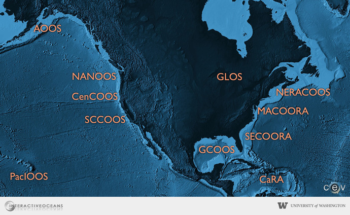 the framework for the IOOS program -- the 17 Federal agencies that it includes and a national network of 11 regional associations. It also designated NOAA as the lead agency. the framework for the IOOS program -- the 17 Federal agencies that it includes and a national network of 11 regional associations. It also designated NOAA as the lead agency.
- Rep. Don Young (R-AK) introduced H.R. 237 "Integrated Coastal and Ocean Observation System Act Amendment of 2017."
- Sens. Roger Wicker (R-MS) and Maria Cantwell (D-WA) introduced S. 1425 "A bill to reauthorize the Integrated Ocean Observing System Act of 2017. Co-sponsors include Sens. Dan Sullivan (R-AK), Lisa Murkowski (R-AK), Lindsey Graham (R-SC), Bill Cassidy (R-LA), Susan Collins (R-ME), Ed Markey (D-MA), Gary Peters (D-MI) and Brian Schatz (D-HI)
The Senate is expected to mark up their bill in early August.
|
The IOOS Federal Advisory Committee Meeting to be held in the Gulf is scheduled for Oct. 24-26 and will take place in Stennis, Mississippi.
Look for details in our September newsletter.
|
Keeping Nowcasts Operational
|
Dr. Mark Luther's team from the University of South Florida were in the field recently working on the
current meter and transmission station located under the Sunshine Skyway Bridge
to help keep  key instruments in Tampa Bay up and running in support of PORTS and TBOFS --
systems that play a critical role in navigational safety for ships in Tampa Bay
. key instruments in Tampa Bay up and running in support of PORTS and TBOFS --
systems that play a critical role in navigational safety for ships in Tampa Bay
.
The Tampa Bay Operational Forecast System (TBOFS) is based on a three-dimensional ROMS model that runs on NOAA's High Performance Computers (HPC). TBOFS provides water level, currents, water temperature and salinity nowcast and forecast guidance as well as interpolated winds from National Weather Service products. TBOFS runs four times per day and generates six-hour nowcasts and 48-hour forecast guidance. TBOFS products include time series graphics at station locations and aerial animations of the whole Tampa Bay for all five parameters (wind, water level, currents, temperature and salinity).
The Physical Oceanographic Real-Time System (PORTS) is a public information acquisition and dissemination technology developed by the National Ocean Service (NOS) in cooperation with the Greater Tampa Bay Marine Advisory Council.
T
he first permanent, fully integrated, operational PORTS
was deployed in Tampa Bay during 1990 and 1991 and integrates real-time currents, water levels, winds, wave height, visibility, air and water temperatures, and barometric pressure at multiple locations with a data dissemination system that includes telephone voice response, modem dial-up, dedicated modem displays and internet sites.
|
$10.8 Million in Resiliency Grants Awarded
|
Gulf Coast communities are frequently challenged by a variety of unique environmental stressors stemming from climate change and both natural- and human-caused disasters. While adverse events are a major challenge for any community, the degree to which communities effectively respond and recover can differ significantly.
The Gulf Research Program (GRP) of the National Academies of Sciences, Engineering, and Medicine and the Robert Wood Johnson Foundation (RWJF) awarded $10.8 million to support four new projects in Louisiana and Alabama aimed at enhancing the science and practice of resilience in coastal communities located in the Gulf of Mexico region.
|
The Gulf of Mexico Alliance is holding a photo contest seeking  images to help populate its website, newsletters and other materials. Photos should relate to any of GOMA's six themes: images to help populate its website, newsletters and other materials. Photos should relate to any of GOMA's six themes:
- Coastal resilience
- Data & monitoring
- Education & engagement
- Habitat resources
- Water resources
- Wildlife & fisheries
The images must relate to the Gulf of Mexico and/or its watersheds within the five U.S. Gulf States. Details here.
|
Congratulations to Caribbean Coastal Ocean Observing System (CariCOOS), Southeast Coastal Ocean Regional Association (SECOORA) and the Alaska Ocean Observing System (AOOS) on being certified as Regional Information Coordinating Entities (RICEs) under the ICOOS Act!
|
Six Restoration Projects Move Forward in Mississippi
|
|
The U.S. Department of the Treasury (Treasury) has issued grant awards for six Mississippi RESTORE projects worth more than $38 million.
The projects include the Mississippi Aquarium ($17 million), the Stennis Hangar ($2 million), Off-Bottom Oyster Aquaculture ($1 million), Fiber Optic Infrastructure Planning ($500,000), Port Bienville Trans-Loading Terminal Facility Completion ($8 million), and the Jackson County Corridor Connector Road - Phase I ($10.2 million).
These projects are part of Mississippi's Initial Multiyear Implementation Plan (MIP) and were proposed to the governor by the GoCoast 2020 Commission and announced in December 2015. On July 7, 2017, Treasury announced the acceptance of Mississippi's amended MIP, which includes an additional $27.34 million in projects.
|
|
NOAA Restore Act Science Program Awards
|
|
The NOAA RESTORE Act Science Program recently completed its second funding competition and awarded approximately $16.7 million to 15 teams of researchers and resource managers to support work on living coastal and marine resources and their habitats in the Gulf of Mexico.
The 15 teams receiving funding are drawn from across 37 institutions including universities, federal and state agencies, and non-governmental organizations. The projects will run for up to three years.
|
|
FREE: Introduction to Remote Sensing of Harmful Algal Blooms
|
|
Learn how satellite remote sensing can help you have more efficient and adaptive plans for water sampling, and how you can apply satellite Earth observations to monitoring HABs during a free webinar training series conducted by NASA.
Harmful algal blooms (HABs) can have a negative impact on the ecosystem and human health. Satellite remote sensing is able to collect data frequently and over a large area to identify impaired water quality from HABs. This data can inform decision-makers on where best to put their resources for taking water samples, determine what toxins are in the water, whether they need to change or move drinking water intakes, and whether a fishery needs to be closed. Remote sensing data enables individuals and organizations to have more flexible plans for water sampling. It also leads to a more efficient and appropriate allocation of resources for protecting human health.
- When: Four, one-hour sessions take place each Tuesday in September (Sept 5, 12, 19, 26)
- Time: 11 a.m. to noon EDT or 9 p.m. to 10 p.m. EDT (The sessions will be broadcast twice per day to allow for international participation.)
- Learning Objectives: Identify NASA's Earth Science remote sensing data products for the identification and monitoring of HABs; describe how coupled remote sensing and modeling approaches are used in decision support tools; use a selection of NASA Earth Science data tools to monitor HABs.
- Intended Audience: Local, regional, state, federal and international organizations interested in using satellite imagery for coastal and ocean applications. Governmental and non-governmental organizations in the public and private sectors engaged in environmental management and monitoring will be given preference over organizations focused primarily on research.
- Registration required. Register now.
|
Restoration Funding Calendar
- NOAA RESTORE Act Science Program hosts a three-year calendar that consolidates planned funding opportunities
By State:
|
Postdoc and Data/Informatics Positions in Global Biodiversity Science
|
Several positions are available associated with the Yale Center for Biodiversity and Global Change, Map of Life and the Jetz Lab, for positions beginning October to April 2017-2018 (there is flexibility). To apply please send (in a single pdf), a short cover letter, CV and contact info for three references to [email protected]. For questions or associated Ph.D. opportunities contact [email protected]. The final selection process will begin on Aug. 18, 2017, but applications before this date are welcome and will be reviewed as received.
- Postdoc: Integrated models of biodiversity distributions and change. We are seeking a postdoc (2-3y) addressing questions and research opportunities surrounding uncertainty-assessed models of species (co-)occurrences over time. Project work would benefit from range of carefully curated biodiversity data sources and novel remotely sensed layers from associated NASA projects. Contingent on funding, the position may address specific GEO BON use cases in support of Species Populations Essential Biodiversity Variables. We are open to a candidate's preferred taxa, regions and questions and animal/plant and terrestrial/marine/freshwater expertise -- qualifications and vision are more important than a specific system. We seek someone with as strong quantitative background and ability to traverse community- and single-species perspectives and spatial scales.
- Postdoc: Mountain biodiversity change. A postdoc position (1-2y) is available to address questions surrounding spatial patterns and temporal changes in global mountain biodiversity. This position will build on the data and infrastructure collaboration of the Global Mountain Biodiversity Assessment and Map of Life. Targeted work aims to document the evidence base and causes behind geographical mountain biodiversity patterns and to integrate information about change and protection in support of Target 4 of Sustainable Development Goal 15. The successful candidate will have excellent spatial biodiversity modelling skills and statistical background, first-hand experience with observational field data collection, knowledge of global change scenarios and models, and a passion for mountain biodiversity.
- Postdoc: Global macroevolution and macroecology. We are seeking a postdoc (2-3y) to work on questions of species and trait diversification and the evolution of niche-relevant traits in geographic space and across spatial scales. Focal taxa include vertebrates, but we are open to work on invertebrate or plant taxa. The candidate should have a strong background in phylogenetic comparative methods and rate-based diversification analyses and ideally prior experience in the assembly of phylogenies, geospatial analyses, and a solid natural history background. Familiarity with R, python, and bash is desirable, as are strong writing and verbal communication skills, a successful track-record of publications, and strong team-working skills.
- Spatial Biodiversity Data Architect/Manager. Map of Life is seeking a qualified candidate to join their international team to help oversee the management (and analysis) of species occurrence information and associated metadata. The successful applicant will work with software engineers and research team to build, extend, support, and manage new databases driving biodiversity web and mobile applications. The ideal candidate will be a quick learner, self-driven, and detail oriented. We require experience in working with geospatial and biodiversity data and the PostgreSQL/PostGIS environment, and python and shell scripting skills. See also https://mol.org/careers.
- Biodiversity Web developer. Map of Life is seeking a Front-end Web Developer to join their international team and participate in the design, development, deployment, and maintenance of mol.org web applications and the API that support them. We require familiarity with Google Cloud Platforms (BigQuery, Cloud SQL, Cloud Datastore) and hosted platforms such as Google App Engine and CARTO. We require experience in developing responsive web applications in HTML5 and CSS3 on JavaScript frameworks such as Angular and React. See also https://mol.org/careers.
|
GRP Hiring Senior Financial and Administration Officer
|
The
Gulf Research Program of the National Academies of Sciences, Engineering, and Medicine has an opening for a
Senior Financial and Administration Officer to direct and manage the financial, budgeting, and administrative activities of the Program to ensure responsible financial management, compliance with federal rules and regulations, and stewardship of $500 million in assets.
This is a unique opportunity to get involved in a relatively new and growing program that funds grants, fellowships and other activities in the areas of research and development, education and training and environmental monitoring. More information is available here.
|
Mirzayan Fellowship Applications Due by Sept. 8
|
Are you a graduate student or a recent graduate whose work is relevant to the Gulf of Mexico and the Gulf Research Program's mission and goals? Apply to be the Gulf Research Program's 2018 Christine Mirzayan Science & Technology Policy Graduate Fellow by Sept. 8, 2017.
Our fellow will join a cohort of about two dozen other fellows for 12 weeks (Jan. 16 - April 6, 2018) at the National Academies of Sciences, Engineering, and Medicine in Washington, DC. He or she will learn about the role of science in the federal government while working directly with Gulf Research Program staff and our Advisory Board. More information about this opportunity is available on our website. To access the online application, please visit the Mirzayan Fellowship website.
|
Ph.D. and M.S. Research Assistantships: Aquatic Ecology/Limnology
Auburn University, School of Fisheries, Aquaculture, and Aquatic Sciences
|
Two graduate research assistantships (Ph.D. or M.S.) in aquatic ecology/limnology are available in Alan Wilson's lab at Auburn University (www.wilsonlab.com). Current lab research projects take advantage of our large field station that includes hundreds of aquaculture ponds and nearby recreational and drinking water reservoirs where we pursue basic and applied questions associated with understanding the ecological, evolutionary and limnological mechanisms controlling the structure and function of freshwater plankton communities. Harmful algal blooms are the foci for many of our projects. My students are welcome to participate on existing projects, which include large-scale field experiments and monitoring, lab-based analytical analyses and modeling but are strongly encouraged to develop their own projects in addition to applying for external grants and fellowships.
I am motivated to maintain a productive, diverse lab and want to encourage students from under-represented groups to consider joining us. Moreover, lab members have numerous opportunities to engage students from institutions with limited research opportunities, students with disabilities and students in financial need in their research and outreach projects through current NSF projects (REU, INCLUDES, S-STEM).
Qualifications: Ideal candidates will be hard-working, honest, highly motivated, team-oriented and excited about studying freshwater communities using lab and field-based approaches. Prior coursework in ecology and statistics, a strong interest in mentoring undergraduates and participating in outreach and relevant research experiences (including analytical skills, such GC-MS, GC-FID, HPLC, ELISA) are desirable. Minimum qualifications include a B.S./B.A. (for M.S. position) or M.S. (for Ph.D. position) in Biology, Ecology, or related field; GPA of 3.2 or greater; and above average GRE scores (at least 50th percentile for quantitative and verbal; at least 4.0 for analytical writing). Support: Graduate research assistantships include 12-month stipend and full tuition coverage.
Start date: Flexible but early 2018 would be ideal considering current projects
How to apply: Interested students are encouraged to email Alan Wilson ([email protected]) describing why the lab is a good fit for you by Nov. 1, 2017 for full consideration. Please include CV, GRE scores, copies of transcripts and contact information for three references.
|
September
International Radiowave Oceanography Worshop, September 19-21, 2017 in Luneburg, Germany. The successful series of the international Radiowave Oceanography Workshop (ROW) has focused on the scientific aspects of ocean applications of high frequency radars. ROW 2017 is the next in this series and will provide a forum for researchers to discuss their results, swap data and algorithms, and identify priorities for future research.
If you would like to participate please refer to the registration section. See the Important dates.
October
GCOOS BOD/Members Meeting, Oct. 11-13, 2017, Mobile, AL.
IOOS Advisory Committee Meeting, Oct. 24-26, 2017.
Hydric Soils Identification Course Oct. 19-20
LSU's College of the Coast & Environment's Department of Oceanography and Coastal Sciences will host a two-day workshop addressing the field identification and delineation of hydric soils. Workshop attendees will gain the skills required to identify hydric soils in the field and conduct hydric soils delineations within Louisiana and across the Gulf Coast Region. Additionally, the workshop will be applicable to those working throughout the Atlantic region and other areas of the country. Registration is limited.
- Accommodations at the Staybridge Suites, 4001 Nicholson Dr., Baton Rouge, LA 70808 (225.456.5431), must be booked by Sept. 18, 2017, for the group rate. If calling, please refer to the Hydric Soil Identification Course for group rate. Group Code: HSC
- Registration
Gulf of Mexico Oil Spill and Ecosystem Sciences, February 5-9, 2018, New Orleans, LA. Don't forget, the conference is still accepting abstracts that promote fundamental Gulf ecosystem science or link scientific results to ecosystem resilience, oil spill response, or restoration and management. The deadline to submit an abstract is September 11, 2017.
|
|
Share Your News with GCOOS
|
Do you have a meeting, job or funding announcement? Please let us know so we can help spread the word. Email info, including all pertinent details and website links, to Laura Caldwell, GCOOS Staff Assistant, [email protected].
Are you starting or finishing a research project, reporting new findings, have a new publication or other big news to share with the GCOOS community? Please email our Public Relations and Content Coordinator, Nadine Slimak at Vetted Communications, [email protected].
|
|
|
|
|