|
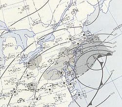
Daily Weather Map 1 AM March 19 1956 US Weather Bureau
The recent snowstorm this March brings back memories of the big snows of March 1956. In New England winter can still rule in March and heavy snows can indeed occur. Even April can see heavy snowfalls - a future SkyMail will talk about that month.
March 1956 started with 6.4" of snow on the ground at Blue Hill Observatory. By the end of the month, three 12 inch plus snowstorms had blanked the Northeast bringing the monthly total to 49.4" making the winter of 1955-56 the third snowiest on the Observatory's 132 year record.
Of the three major snowfalls in March 1956 the storm from March 18-20th was the most significant with upwards of 20 inches falling along the Northeast corridor and much of Southern New England. What was remarkable was that there were three snowstorms in March 1956 in a period of just 10 days. The storms started with a rather typical coastal development on March 14th which left 2.3" of snowfall at Blue Hill Observatory. The next storm was just two days later.
On Friday, March 16, 1956, by 1230 GMT the stage was set for the typical development of a coastal Low which often produces heavy snow and high winds in the Northeast. The North Atlantic States had been flooded with cold air due to eastward passage of a 1032-mb High from the Great Lakes region to Maine. Meanwhile, a wave, which developed in the West Gulf on the trailing polar front, had deepened and moved northeastward to eastern Kentucky. This was attended by widespread heavy rains in the Southeastern States and snow through the Ohio Valley eastward to southern New Jersey. By this time the typical pattern of development was evident. A warm front lay along the Carolina coast, then extended eastward north of Bermuda. An area of 3-hourly pressure falls of 4 to 5 mb, concentrated in eastern North Carolina and southeastern Virginia, strongly indicated a secondary development on the coast. By 0030 GMT, March 17, the low center in eastern Kentucky had entirely filled and the secondary Low had formed and deepened to 984 mb just off Atlantic City, N. J. The pressure at Atlantic City fell 25 mb in just 12 hours, indicating the explosive nature of the cyclogenesis which took place. Snow had now spread over all of the North Atlantic States, attended by strong winds with gales on the coast. By 0630 GMT, March 17, the center was 970 mb just east of Nantucket. Snow and strong winds covered the Northeastern States and gales continued on the New England coast. By 1230 GMT, March 17, the storm was well out to sea some 380 miles east of Boston. This storm was a nearly perfect example of the rapid development of a coastal storm. It deposited 14 inches of new snow at Albany, N. Y., 6 inches at Hartford, Conn., and 10 inches at Concord, N. H., New York City and Boston. In just 12 hours the intense storm moved from a position off the coast near Atlantic City to 380 miles east of Boston. Snowfall at Blue Hill Observatory measured 12.9 inches.
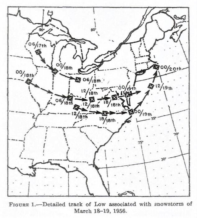
All of this set the stage for the biggest storm which occurred from March 18-20th. By early morning of the 18th (1230 GMT) the area of snowfall attending the developing southern low centers over eastern Kentucky and southern West Virginia had enlarged to cover the Ohio Valley and had spread eastward over the Appalachians to cover most of the mid-Atlantic states. Precipitation fell as rain over southern Maryland and southern Virginia, while snow was falling over the remainder. Snow had spread from southern New Jersey, beginning at 1545 GMT at Newark and 1603 GMT at New York City. At this time one low center was moving eastward near Quantico, Va., while another was also moving eastward near Danville, Va. During the next 6 hours there was little change in the area of precipitation. Showers and thunderstorms moved eastward across southern Virginia and eastern North Carolina as the southern low center moved to the coast near Elizabeth City, N. C. and began to strengthen into a dangerous gale. Snow continued from Maryland and Delaware northward over Pennsylvania and into Long Island as well as westward to Cincinnati, Ohio, as the northern Low center moved to southern Delaware. By 0630 GMT on the 19th the surface Low system was off the coast, some distance southeast of New Jersey, moving northeastward. Snowfall continued over the New York City area, New Jersey, Delaware, Maryland, and eastern Pennsylvania. On the 19th the snow spread over Southern New England. Meanwhile, the low pressure cyclonic center moved northeastward along the coast at an ever-slowing rate toward Nantucket, finally passing to the northeast of that point and filling on the 20th, while a new center formed farther east near Sable Island. It is interesting to note that the duration of precipitation in the form of snow at Philadelphia, Trenton, Atlantic City, Newark, and New York City (Battery) ranged from 31 hours at Philadelphia to 35 hours at Atlantic City. Farther east, over Southern New England, the duration ranged from 26 hours at New Haven to 24 hours at Boston. In spite of this, the depth of new snow added by the storm was remarkably uniform, measuring 12 to 13 inches at Trenton, New York City, New Haven, Bradley Field (Hartford), and Boston. A notable exception was the 18 inches which fell at Newark. Snowfall at Blue Hill was 17.5" with a total snowfall on the ground on the 20th of 25.3".
All in all, this was one of the most severe and deadly snowstorms in Southern New England history. Approximately 162 people were killed and most towns were left paralyzed under deep snow drifts as high as 14 feet.
As if this wasn't enough the blizzard of March 18-20 was followed by another 12.3" snowfall on March 24th with a final 3" falling from 3/29 to 3/30/56. Many of us remember shoveling much of the month, fortunately under a warm March sun!
Credit for these graphics and content of this article is given to Mook and Norquest Monthly Weather Review March 1956. Mook and Norquest acknowledge the help pf Dr David Atlas who provided radar data from the radar then located on top of Great Blue Hill with the radar office in a Quonset hut in the backyard of the Observatory.
|