|
Spring 2018
|
Volume 7| Issue 2
|
|
|
|
 |
2018 has been designated by the
International Coral Reef Initiative
as the third
International Year of the Reef
(IYOR), and NOAA
is an IYOR partner. This yearlong designation aims to strengthen awareness globally about the value of, and threats to, coral reefs and associated ecosystems; promote partnerships between governments, the private sector, academia and civil society on the management of coral reefs; identify and implement effective management strategies for conservation, increased resiliency and sustainable use of these ecosystems and promoting best practices; and share information on best practices related to sustainable coral reef management.
Within the Caribbean, many countries are leading the way with their celebrations:
Also on World Oceans Day, St. Croix is hosting the
Coralpalooza Festival of reef restoration in support of the IYOR.
The National Gallery of the Cayman Islands has opened its doors to 30 local and international underwater photographers for a stunning display of the best of the marine environment of the Cayman Islands.
Coral Encounters: Photographs from our Underwater World is running from now to 16th August.
Heading south, Trinidad and Tobago have been making great strides in raising awareness of their coral reefs by creating an IYOR partnership with
SpeSeas,
Wild Tobago, the
Institute of Marine Affairs and T&T Field Naturalists' Club. Starting with the first ever public screening of Chasing Coral within T&T on World Environment Day (5th June), followed by their official IYOR launch on World Oceans Day (8th June).
For more information on NOAA's coral reef work and IYOR activities, please visit:
Story contributed by Kirsty Richards, IYOR Coordinator; and by NOAA National Ocean Service.
|
|
|
Feature Stories
|
Spawning Aggregations Working Group Meeting
|
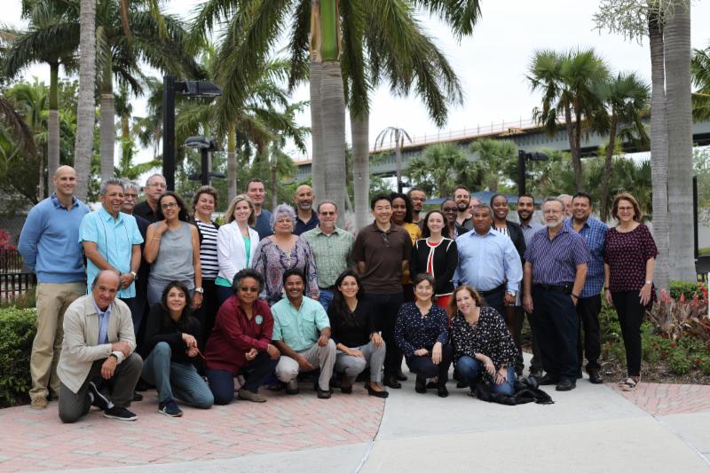
The 2nd Meeting of the Caribbean Fishery Management Council (CFMC)/Western Central Atlantic Fishery Commission (WECAFC)/Central America Fisheries and Aquaculture Organization (OSPESCA)/Caribbean Regional Fisheries Mechanism (CRFM) Working Group on Spawning Aggregations was held in Miami, March 27-29. NOAA Fisheries played an integral role in meeting organization. The recent listing of Nassau grouper under the Endangered Species Act, coupled with the inclusion of Nassau grouper under Annex III of the Specially Protected Areas and Wildlife Protocol (SPAW Protocol of the Cartagena Convention) calls for regional cooperation for managing and conserving the species. The Office of Protected Resources (OPR) coordinated closely with the Caribbean Fishery Management Council (CFMC) to fund and organize the meeting. Two staff (Chelsey Young from OPR and Stephania Bolden from the Southeast Regional Office) assisted in meeting organization and attended on behalf of NOAA. Participants included scientists and researchers, government managers, non-governmental organizations, outreach and communication specialists, members of academia and other various stakeholders from across the Wider Caribbean Region (WCR).
The working group expressed a sense of urgency in needing to protect spawning aggregation sites and species that aggregate to spawn across the WCR. After many informative presentations and in-depth discussions, the working group revised and updated the 2013 recommendations from the first working group meeting that were adopted at the 15th Session of WECAFC. More importantly, the working group also drafted and adopted a 2-year work plan that outlines several action items to be undertaken between 2018-2020, notably, the development of a Pan-Caribbean fishery management plan for species that aggregate to spawn, with Nassau grouper as a focal species. Overall, participants indicated the meeting was very productive and successful in its objectives.
Story contributed by Chelsey Young, Natural Resource Management Specialist, NOAA Fisheries.
For more information, contact: [email protected]
|
|
|
Spawning Aggregations Working Group.
|
|
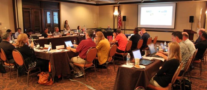
Caribbean Fishery Management Council (CFMC) moves to Island-Based Fishery Management Plans (IBFMP)
|
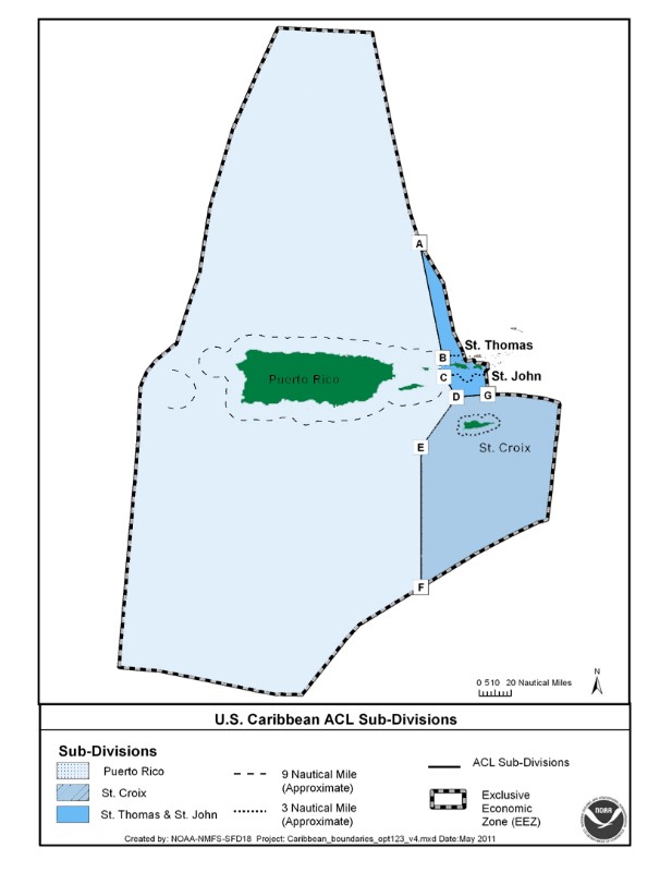
The Caribbean Fishery Management Council (CFMC) is responsible for the development and implementation of fisheries management in the U.S. Caribbean with the goal of maintaining sustainable fishery resources. Its jurisdiction includes the islands of Puerto Rico and the U.S. Virgin Islands (USVI; including St. Thomas, St. John and St. Croix). Since 1970, management plans for queen conch, spiny lobster, coral reef fishes, and corals, among others, have been produced and applied to the islands as a unit. This approach is about to change.
|
|
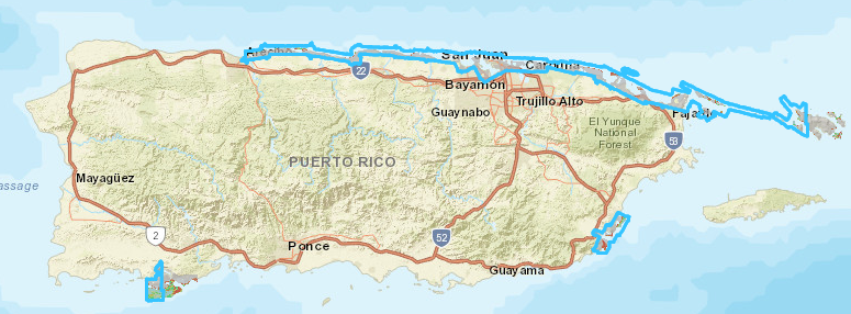
| The CFMC jurisdiction includes Puerto Rico, St. Thomas, St. John and St. Croix. |
The islands of the U.S. Caribbean may be close in distance, but their marine ecosystems are not all the same. Puerto Rico, St. Thomas and St. John occupy the same submerged platform; however, St. Croix rests on a separate platform with very deep waters. These differences in water depths lead to differences in the marine ecosystems and species available for capture in fisheries. Cultural and socioeconomic differences are also notable. The official language in Puerto Rico is Spanish, while English is the dominant language in the USVI. Different historical origins of their populations mean different fishing practices, gear, and catch composition. The local differences in consumer preference influence market demand for particular seafood products, which in turn drives island-based differences in the fishers' target species.
Because of the important cultural, socioeconomic and environmental differences between the islands under CFMC's jurisdiction, the Scientific and Statistical Committee (SSC) and the Southeast Fisheries Science Center (SEFSC) are currently developing new Island-Based Fishery Management Plans (IBFMPs) for Puerto Rico, St. Thomas/St. John and St. Croix. As mandated in the Magnuson-Stevens Fishery Conservation and Management Act, socioeconomic aspects of fishing communities must now be integrated into Ecosystem-Based Fishery Management Plans.
The new IBFMPs are being developed in consultation with stakeholders, and the CFMC expects them to be completed and presented to the U.S. Department of Commerce by 2019.
|
|
| Discussing IBFMPs at a CFMC meeting in St. Croix, USVI, on April 19, 2017. |
Story by Dr. Alida Ortiz, Outreach and Education Advisory Panel (OEAP) Chair, Caribbean Fisheries Management Council (CFMC).
For more information, contact: [email protected]
|
|
CARIBE WAVE 2018:
A Decade of Promoting Tsunami Awareness and Readiness Through Exercises in the Caribbean Region and Western Atlantic Ocean
|
The National Tsunami Hazard Mitigation Program and the CARIBE Early Warning System (EWS) was established by the United Nations Educational, Scientific and Cultural Organization (UNESCO) in 2006 after the devastating Indian Ocean Tsunami and the recognition of the high tsunami threat in the Caribbean.Tsunami exercises have been conducted annually in the Western Atlantic and the Caribbean since 2009. When the first exercise took place in 2009, it was called LANTEX (Large AtlaNtic Tsunami EXercise) and included the Eastern coasts of the United States and Canada, Gulf of Mexico, Puerto Rico and the Virgin Islands. The focus was mainly on communications, and hundreds of people participated. LANTEX was conducted again in 2010 and 2012.
At the recommendation of the UNESCO Intergovernmental Coordination Group for Tsunamis and other Coastal Hazards, LANTEX was extended in 2011 to include all the Caribbean and adjacent regions and the exercise was renamed CARIBE WAVE/LANTEX. For four years (2011 and 2013-2015), NOAA's National Tsunami Warning Center (NTWC) and Pacific Tsunami Warning Center (located in Hawaii) collaborated in testing the issuance of their tsunami products through the standard broadcast channels for dissemination during the annual exercises.
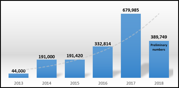
Since 2016, the tsunami exercise for the Caribbean and adjacent regions has involved exclusively the CARIBE EWS Member States and Territories, including Puerto Rico and the US Virgin Islands. Participation in CARIBE WAVE reached a record high in 2017 with a total of 679,938 participants, positioning this tsunami exercise as the largest simulation exercise of its kind in the world.
On March 15, 2018, over 389,000 people from across the entire Caribbean basin-from Bermuda to Brazil-signed up to participate in the 10th collective regional tsunami exercise, CARIBE WAVE 2018. CARIBE WAVE 18 was the first large scale exercise conducted in the region since Hurricanes Irma and María. It was also the first time Brazil participated as an official Member State of the EWS. Registered participants included designated CARIBE EWS Tsunami Warning Focal Points (TWFPs) and NTWCs, as well as emergency and preparedness organizations, K-12 schools, government agencies, colleges and universities, healthcare providers, businesses, hotels, and senior facilities/communities, among others.
|
|
Participation in tsunami exercises each year from 2013 to 2018. The graph indicates a gradual increase over time in the number of people participating, with the record high registered in 2017.
|
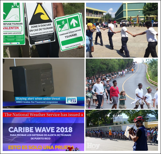
One of the main objectives of these exercises is validating the communication systems to receive and disseminate official information, which includes: sirens, emails, emergency alerts, text messages, media outlets, and social media. In addition to the communication tests, other exercises including seminars, tabletop exercises, and preparedness drills such as those in Puerto Rico were organized as part of the commemoration of the 100 years of the 1918 Earthquake and Tsunami. CARIBE WAVE 18 was especially important for many countries who lost communication assets after Hurricanes Irma and Maria. During the exercise, these countries were able to test alternative communication systems and gauge recovery of notification systems.
Planning for the tsunami exercises takes over a year of preparation. Each year a CARIBE EWS Task Team is established to provide guidance with NOAA's National Weather Service (NWS) Caribbean Tsunami Warning Program serving as coordinator. TsunamiZone.org has been used for the past three years for participant registration because the site allows organizers to determine the number and type of participants, an important metric to evaluate the effectiveness of the exercise in the region served by the CARIBE EWS.
|
|
| Main objectives of the exercises during the past ten year: communication tests, tsunami plan reviews, and evacuation drills. |
Story contributed by Christa von Hillebrandt-Andrade.
|
|
New LIDAR datasets for Puerto Rico and Florida
|
Three new Topobathy LIDAR datasets for Puerto Rico and Florida have been recently added to the
Digital Coast service.
LIDAR (LIght Detection And Ranging) is a remote sensing method used to examine the surface of the Earth. NOAA scientists are using LIDAR to produce more accurate shoreline maps, make digital elevation models for use in geographic information systems, to assist in emergency response operations, and in many other applications. LIDAR data sets for many coastal areas can be downloaded from the Office for Coastal Management Digital Coast web portal. Topobathy datasets seamlessly merge topography and bathymetry into a single dataset.
2016 NOAA National Geodetic Survey (NGS) Topobathy Lidar: Puerto Rico
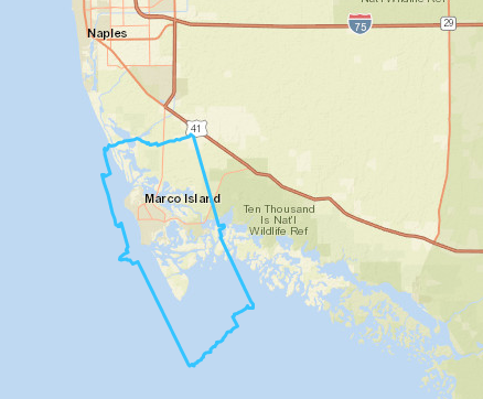
2016 NOAA NGS Topobathy Lidar: Marco Island (FL)
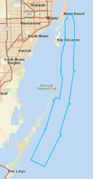
2017 NOAA NGS Topobathy Lidar: Florida Keys Outer Reef, Block 04
Story contributed by Adam Bode, Regional Geospatial Coordinator at The Baldwin Group, Inc., on contract for NOAA's Office for Coastal Management.
For more information, please contact: [email protected]
|
Upcoming Events
|
Hurricane Awareness Webinar Series
NOAA's Southeast and Caribbean Regional Collaboration Team (SECART) is pleased to host a Hurricane Awareness webinar series in advance of the 2018 Atlantic Hurricane Season. The webinars are intended to improve the understanding of NOAA's hurricane-related products and services, so that, with our partners in the emergency management and broadcast communities, we can build a Weather Ready Nation.
The five-part series (see below) includes topics such as tropical cyclone research and forecast improvements, understanding uncertainty in forecasts, and inland flooding. Speakers include NOAA experts from the National Hurricane Center (NHC), the Atlantic Oceanographic and Meteorological Laboratory (AOML), the Weather Prediction Center (WPC), and National Weather Service (NWS) Weather Forecast Offices (WFOs). The fifth webinar in the series presents highlights of the other webinars and will be presented in Spanish for our Spanish-speaking constituents.
How do I attend?
To participate in any of these webinars, go to:
join.me/NWS_Miami at the designated date and time of the webinar. Webinars are scheduled to be recorded and made available on the
SECART website once the series is completed.
2018 Webinar topics and dates:
Passed (recording will be made available online):
Contributions of the Hurricane Forecast Improvement Project and the Future of NHC Products and Services
May 8, 2018 10 - 11 AM EDT
Dr. Frank Marks - NOAA AOML Hurricane Research Division
Dr. Michael Brennan - NOAA National Hurricane Center
Success and Challenges of the 2017 Hurricane Season
May 15, 2018 at 10-11 AM EDT
Mr. Robbie Berg and Mr. Dan Brown - NOAA National Hurricane Center
Upcoming:
Inland Flood Forecast Challenges
May 22, 2018, 10 - 11 AM EDT
Mr. Greg Carbin - NOAA Weather Prediction Center
Mr. Lance Wood - NOAA National Weather Service, Houston, TX
Dealing with Forecast Uncertainty in Decision Making
May 29, 2018 10 - 11 AM EDT
Mr. Robbie Berg - NOAA National Hurricane Center
Mr. David Sharp - NOAA National Weather Service, Melbourne, FL
Summary of hurricane research, forecast uncertainty and challenges, and the future of NHC products for 2018 (in Spanish)
June 19, 2018 10 - 11 AM EDT
Mr. Roberto Garcia - NOAA National Weather Service, San Juan, RP
Ms. Shirley Murillo - NOAA AOML Hurricane Research Division
|
Webinar series on Sustainable Infrastructure & Resilience
Long before Hurricane Maria made landfall on Puerto Rico, the University of Puerto Rico established the National Institute for Energy and Island Sustainability (INESI) as a collaborative platform to understand and address the infrastructure issues being faced by the campus system and island.
Moderator:
Gary Dirks, Ph.D. - Director, Julie Ann Wrigley Global Institute of Sustainability at the Arizona State University (ASU)
Speakers:
Cecilio Ortiz García, Ph.D. - University of Puerto Rico - Mayagüez
Jennie Stephens, Ph.D. - Associate Director for Strategic Research Collaborations, Global Resilience Institute (GRI) at Northeastern University and co-chair of the NCSE Energy Education Community of Practice.
Clark Miller, Ph.D. - ASU's School for the Future of Innovation in Society and the Global Institute of Sustainability
|
Funding Opportunities
|
|
IDEA WILD Small Equipment Grants for Protected Areas Management
IDEA WILD seeks to minimize the loss of biodiversity by empowering people on the front lines of conservation by awarding small equipment grants to conservation professionals around the world. These equipment grants advance biological research, conservation education, community outreach, conservation management, field training, and professional development in areas where it is needed most. By empowering both aspiring and veteran conservation professionals, IDEA WILD has been instrumental in establishing new protected areas, reversing the decline of species through innovative management plans, restoring damaged and critical habitat, and improving how local communities support and sustain their immediate natural resources. Each year, IDEA WILD distributes over $300,000 worth of equipment - including digital cameras, spotting scopes, mist nets, tents, binoculars, and GPS units - to over 400 conservation projects worldwide.
IDEA WILD focuses its support on professionals working in developing countries where other sources of support are limited or nonexistent, and where a $750 equipment grant is often equivalent to several months' salary. IDEA WILD accepts proposals from ALL countries.
Priority consideration is given to projects with:
-
A strong biodiversity conservation aspect;
-
Direct involvement with nationals of the country where the project takes place (if you are non-national, it is best to have a national apply or co-apply);
-
Plans to further use (recycle) equipment after the project has completed; and
-
A valid US contact who can receive your equipment.
This is a continuous funding opportunity with no deadline; applications are accepted on an ongoing basis. For more information, please visit:
http://www.ideawild.org/apply.html
|
|
American Planning Association (APA) Disaster Recovery
In response to the 2017 hurricanes and disasters, The American Planning Association (APA) members and the APA Foundation partnered to raise funds for disaster recovery community assistance. Planners in communities affected by these disasters are invited to apply for grants to assist their community recovery efforts.
Applications will be accepted and reviewed on a rolling basis through
June 18, 2018. Communities and individuals are encouraged to submit applications as soon as possible.
The following activities qualify for support:
- Travel and professional expenses for APA Community Planning Assistance Teams (CPAT) or similar program in affected communities.
- Expenses for planners in affected communities to attend disaster-focused planning educational events (training, workshops, symposium) based on the following selection criteria (see page 2 of the Request for Proposals form).
- Expenses for disaster mitigation training offered by chapters and divisions in affected communities.
- Knowledge-building programs and/or campaigns that advance local/regional resiliency through planning and design partnerships (e.g., Dutch Dialogues for Katrina).
For more information, please visit:
https://www.planning.org/foundation/rfp/
|
|
EPA Grant for Puerto Rico Youth and Environment Program
EPA Region 2 is soliciting grant applications from eligible applicants for the development of projects in Puerto Rico for eligible post-Hurricane Maria restoration activities in the (1) Vieques Bioluminescent Mosquito Bay; and (2) San Juan Bay Estuary, that involve training, studies and/or demonstrations relating to the reduction of the sedimentation load; elimination of water pollution; and/or the development of an environmental education program and materials through the Youth and the Environment program.
Deadline: May 25, 2018 by 11:59 pm
The EPA's Youth and the Environment Program is designed to introduce underprivileged students between the ages of 18-25 to career opportunities in the environmental field, specifically in the water program.
For more information, please visit:
|
NOAA in the Caribbean Newsletter
Please e-mail us at [email protected] to subscribe or unsubscribe to the newsletter or to submit any questions, comments, story ideas, artwork or photographs.
NOAA in the Caribbean Newsletter is produced by the NOAA in the Caribbean Steering Committee, including support from NOAA's Office of International Affairs,
Southeast And Caribbean Regional Collaboration Team, Office for Coastal Management, National Marine Fisheries Service SE Regional Office, Office of Legislative and Intergovernmental Affairs, and National Centers for Coastal Ocean Science.
|
|
|
|
|