| |
A Newsletter from the Connecticut Department of Energy & Environmental Protection Exploring Long Island Sound - Issues and Opportunities |
|
| |
Welcome to the 50th Issue of Sound Outlook
 |
The October 2015 issue of
Sound Outlook marks the publication's 50th edition. When Sound Outlook was launched back in June of 1999, our intent was to bring readers "the latest on current projects, events, and information, as well as tips on how we can all help protect the health of the Sound." We hope we've succeeded in doing that and more.
To celebrate 50 issues, this edition
takes a look back at that very first issue to see how far we've come
over the
past 16 years
in meeting our initial intent to better protect Long Island Sound. We'll review our efforts to reduce nitrogen and plan on a watershed basis, and we'll report on updates to Connecticut's coastal public access guide.
This issue also includes subjects that weren't even anticipated in the first issue, including our ongoing Climate Change Update column and an article about the possible establishment of a National Estuarine Research Reserve for Long Island Sound.
So, thank you to all of our readers for supporting 50 issues of
Sound Outlook. Get ready to party like it's 1999!
|
 Is the Sound Too Rich?
Nitrogen in Long Island Sound:
Too Much of a Good Thing is Bad
The first issue of
Sound Outlook debuted a column that asked, "How's the Water?" to report on water quality conditions and identify information sources about water quality. That's because water quality in Long Island Sound has long been a major concern, especially as it relates to swimming and fishing. DEP had already been asking "How's the Water" long before that June 1999 issue was released.
But in an estuary like Long Island Sound, there is no simple "good" or "bad" answer to the question, "How's the water?" A better response might be, "It's complicated." But we can look at water quality monitoring data to see how the water is in the Sound now, and determine if has been better or worse in the past.
About 30 years ago, the states of Connecticut and New York took a look at the Sound from a biochemical water quality point of view. There were growing observations of fish kills, eel grass die-offs, and tidal marsh destruction occurring in and around the Sound and people wondered if something in the water was causing these problems. So the two states conducted an initial 3-year study [the beginnings of the Long Island Sound Study (LISS)] to look at the physical and chemical properties of water that are essential to healthy plants, animals, and people living in and around Long Island Sound.
|
|
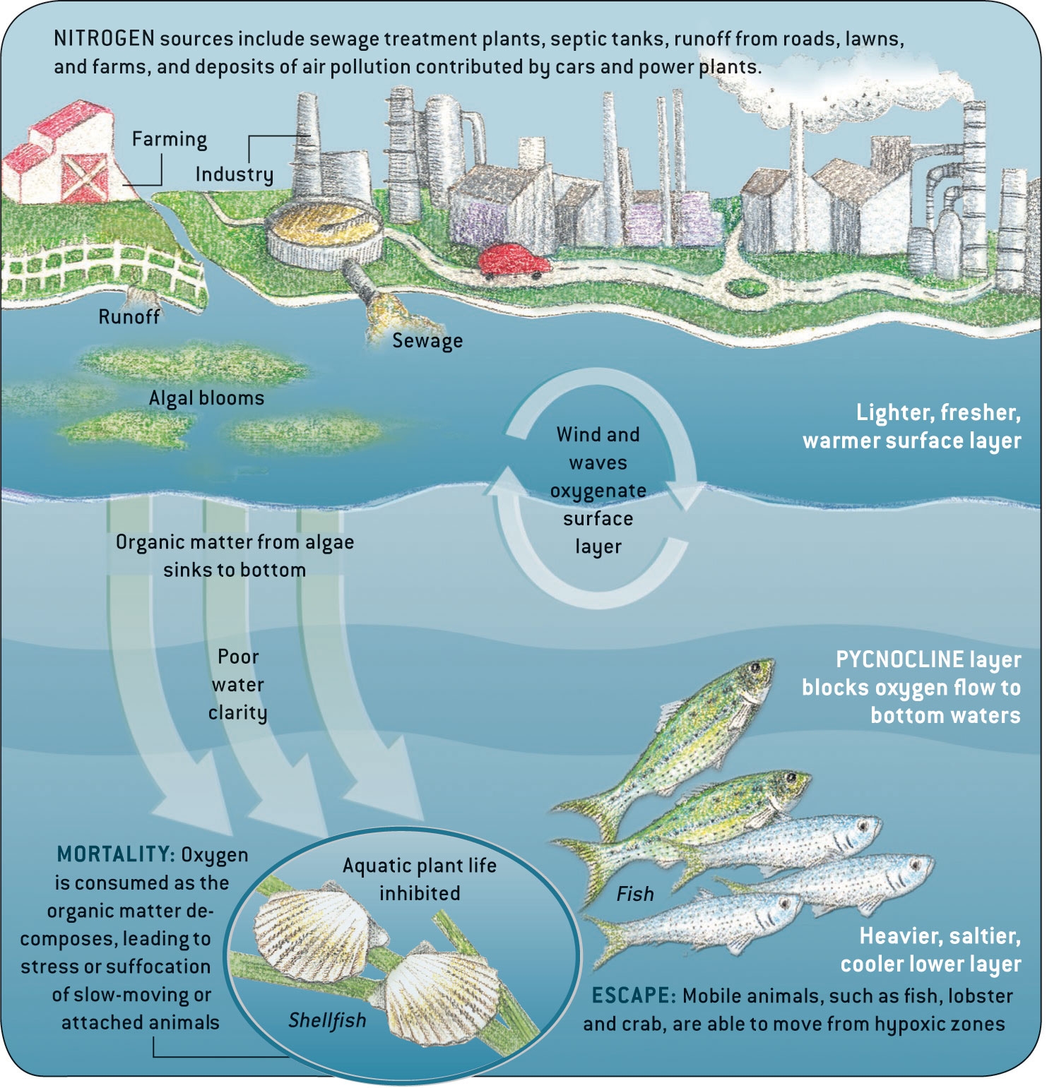
Hypoxia Diagram
Source: Long Island Sound Study |
One of the primary elements needed for aquatic life is the amount of free oxygen dissolved (or mixed) in the water. Just as people need oxygen in the air to breathe, aquatic organisms need dissolved oxygen (DO) in the water. A healthy level (or water quality standard) for DO in the Sound is at or above 5 parts per million (ppm), or 0.00005%. The study conducted in 1987-1989 found that from mid- to late-summer, DO in the bottom waters of Long Island Sound dropped to life-threatening low levels for aquatic plants and animals, a condition known as hypoxia. It was found that hypoxia in large bodies of water occurs when a natural condition called stratification (i.e., layers of fresh water riding over salt water, and warm water riding over cold water) is coupled with the addition of nutrients, such as nitrogen-containing compounds, into the waters.
When the waters of the Sound get too much of a good thing, they become nutrient rich. This nutrient enrichment spurs algae to grow so fast and in such great numbers in the surface waters that aquatic animals can't eat it all. The excess algae floating in the water blocks out the sunlight from reaching the bottom-anchored seaweeds that need sunlight in the near-shore waters to help them live. In addition to the lack of sunlight reaching the bottom waters of the Sound, all the excess algae and fecal matter of the plankton eating the algae settle down through the bottom waters where they decay, using up the dissolved oxygen and leaving little or no DO for fish and shellfish to survive.
The "pycnocline" layer that is formed between lower density surface water and higher density water that sinks to the bottom prevents oxygen from being able to flow to bottom waters.
This may be an over-simplified explanation of a complex system that is intricately interconnected (it's complicated, remember?). But since most life forms need certain basic elements such as oxygen and nitrogen, hypoxia is the most likely explanation for the fish kills observed in Long Island Sound in the late 1980's and early 1990's.
As the initial 3-year study evolved into the LISS, research conducted by the LISS partners determined that hypoxia occurs as a result of certain natural biological, chemical, and physical conditions occurring in concert, and has probably always naturally occurred in Long Island Sound. But the LISS also found that hypoxia has worsened over time as a result of increased human activity. Over the last 200 years, human activity has added extra nitrogen to the Sound, and DO levels in some bottom waters in the Sound today fall well below natural conditions.
In 1990, Connecticut and New York adopted a Nitrogen Reduction Strategy (NRS) and began working with the 106 municipal sewage treatment plants in the Long Island Sound watershed to reduce the amount of human-caused nitrogen compounds being discharged into the Sound. The first step (Phase I) called for a freeze on nitrogen discharges ("No Net Increase of Nitrogen") from 33 coastal municipal sewage treatment plants (STPs). In 1994 the LISS partners committed to Phase II of the NRS which implemented low-cost retrofits and other process modifications to reduce the nitrogen levels in the discharges at 18 of the coastal STPs. By 1998, Phase III Actions for Hypoxia Management were adopted that established eleven management zones around the Sound and set specific nitrogen reduction targets for each of the zones. Thus, DEP had made great strides in improving water quality before the June 1999 debut of
Sound Outlook.
Sewage treatment plant discharges were found to be a major source of nutrients getting into the Sound, but nonpoint source pollution and stormwater runoff also contribute significantly to the nitrogen load. So in 2000, Connecticut and New York developed a Total Maximum Daily Load (TMDL) Analysis which set a goal to reduce nitrogen discharges from not only point sources like STPs (known as waste load allocations) but to also reduce nonpoint source contributions
(known as load allocations). Point source loads of nitrogen were to be reduced by 60% of 1990 levels, and nonpoint source contributions of nitrogen within the Long Island Sound watershed would be reduced by 10%.
Today, Connecticut has met its goals for point source nitrogen discharges to the Sound and New York is on track to meet their nitrogen reduction goals by 2017. This was accomplished, in part, through the development of Connecticut's
statewide Nitrogen General Permit and implemented a Nitrogen Credit Exchange program to reduce the equalized load of nitrogen to Long Island Sound. New York chose to issue individual permits to reduce nitrogen discharges from their STPs that discharge to the Sound.
Now the TMDL has moved into Phase IV in which Connecticut, New York, and the upper Long Island Sound watershed states (Massachusetts, New Hampshire, and Vermont) are being engaged to reduce nitrogen loads from nonpoint sources.
Reducing the nonpoint source load will be a bit more . . . complicated, because every one of us contributes a little bit to the problem.
 So, "How's the Water?" All things considered, the water is better! Long Island Sound has responded positively to our collective actions, and the area and duration of hypoxia in Long Island Sound seems to be declining.
 The Sound is less rich (nutrient rich, that is) and water quality is improving. If we all do our part to control nitrogen (see the
Sound Tips column for ways you can help), there will be fewer occurrences of hypoxia and a healthier Long Island Sound.
|
Watershed Planning
We've Come a Long Way in 50 Issues
The
first issue of Sound Outlook asked readers if they were "watershed minded" and introduced them to the innovative concept of watershed planning.
To review, a watershed is an area of land that drains, or sheds, all of its water (e.g., rain runoff, melted snow, water used to hose-down a sidewalk, etc.) to the same receiving waterbody. As that waters runs down through the watershed, it can pick-up sediment, oil, animal scat, and other polluted materials from the ground and deposit them into the receiving waterbody.

The idea of controlling "nonpoint source pollution" across municipal--and state--boundary lines was just taking hold in 1999, and DEP embraced the concept by launching the agency's watershed management program. Initially, the program consolidated DEP water permitting, enforcement, resource management, and public outreach efforts on a watershed scale. But
in the 16 years since its inception, DEEP's watershed management program has evolved, working successfully within and outside of the agency to help establish and implement over 30 watershed-based plans
throughout the state. Some of these watersheds drain directly to Long Island Sound, including the Niantic River, the Quinnipiac River, and the Norwalk River, so the plans developed for those watersheds have a direct positive impact on the quality of the Sound.
However, since all of the land in Connecticut is located within the L
ong Island Sound watershed,
plans developed for watersheds that are not directly connected to Long Island Sound (e.g., Broad Brook in East Windsor, Ellington, Somers, and Tolland) will also protect the Sound by recommending practices that will protect and improve the quality of local waterbodies and other natural resources. Ultimately, protection of local watersheds is protection of Long Island Sound.
Please visit the
DEEP's Watershed Management website to become even more "watershed minded" and see how far we've come in our watershed planning efforts. You may also
contact Chuck Lee, supervisor of the watershed management program at 860.424.3716 for all things watershed-related.
|
|
| |
|
| OCTOBER/NOVEMBER 2015 No. 50 |

 Inside Inside
|
Sound Tips
:
Nitrogen Reduction Remains a Top Priority
In the 16 years since the first issue of
Sound Outlook was published, DEEP has made great strides in reducing the amount of nitrogen that gets discharged to Long Island Sound.
Although we have accomplished a great deal, we must remain vigilant in reducing nitrogen discharges to the Sound every chance we get.
With that in mind, here are a few tips on stopping excess nitrogen in its tracks before it makes its way to Long Island Sound:
- Consider installing a rain garden to treat rainwater before it runs off of your property. The plants in the garden will take-up the nitrogen in the rainwater as fertilizer, reducing the load in whatever excess rain runs off.
- Apply fertilizers no more than twice a year: after plants start to "green-up" in the spring, and no later than mid-October. You're wasting product (and money) if you apply too early or too late in the year--the plants aren't ready to eat yet, or they're shutting down for the winter. If plants can't eat, the fertilizer gets washed away into streams, rivers, and Long Island Sound.
- Consider the use of timed-release fertilizer on lawns and gardens.
- And rather than depending on the fertilizer bag, you should check your soil to determine what type of fertilizer and how much your lawn really needs. Contact the UConn Soil Testing Lab to perform a soil test--it might help you use less fertilizer and actually save some money.
- Give yourself a mowing break: reduce the amount of lawn coverage in your yard! Consider replacing unused portions of your lawn with native plant borders and beds that attract wildlife and provide habitat for important insect pollinators.
- Consider planting a buffer of native plants next to any stream, river, or coastal waterbody that abuts your property. The plants will help take-up extra nitrogen from rain runoff before it ends up in the water and, ultimately, Long Island Sound. And you'll have less lawn to mow at the edge of the stream bank.
- If you're able to squeeze in some last-minute boating this season (now that you have less lawn to mow!), always use a shoreside or mobile pumpout facility to flush your holding tank.
- Always clean up after your pet and properly dispose of pet waste.
|
| View past issues of Sound Outlook |
| Subscribe to Sound Outlook or any other DEEP newsletter |
Look Out For These Other
Upcoming Events!
Long Island Sound Study (LISS)
Committee Meetings
Living Shorelines Meeting and
Regional Workshop
December 1-2, 2015
Hartford Hilton
Hartford, CT
Early Bird Registration Rate until November 16, 2015
Learn More Here
November: Harbor seals arrive in LIS from northern New England; winter flounder move into shallower water
Southbury, CT,
call 1-800-368-8954
after Dec. 19 to register.
|
Dredged Material Management Plan Update
The Long Island Sound Dredged Material Management Plan (LIS DMMP) is an Army Corps of Engineers (ACOE)-led, comprehensive planning process to address the management of dredged material in Long Island Sound (please see our article in the
June 2011 issue of Sound Outlook).
The overall goal of the LIS DMMP is to develop a comprehensive document recommending practicable options to manage dredged material in an environmentally acceptable and economically feasible manner in Long Island Sound for the next 30 years.
The ACOE recently released a draft of the LIS DMMP and an accompanying Programatic Environmental Impact Statement (PEIS) and accepted public comment through mid-October 2015.
The draft DMMP document has identified an array of options that non-federal dredging proponents can utilize to manage their dredged sediments. It also identifies both potential baseline, or least cost environmentally acceptable plans, and recommended management plans for all ACOE Long Island Sound dredging projects.
The expectation is that the LIS DMMP will be completed by January 2016.
For additional information about the LIS DMMP or about dredging in Connecticut, contact
George Wisker at 860.424.3614.
|
|
|
SPOTLIGHTED COASTAL ACCESS:
Connecticut's Coastal Access Guide Gets Better with Age
 Improving public access to the Connecticut shore is one of the cornerstones of Connecticut's Coastal Management Program. In the first issue of
Sound Outlook, we proudly touted the availability of a brand new Connecticut Coastal Access Guide, released in May of 1999 as a paper map of 262 coastal access sites located along the shoreline. Several years in the making, the guide improved information describing where the public could access Connecticut's coast, and at the time of its release it was one of the first of its kind in the nation.
Funded, in part, through a grant from the Long Island Sound License Plate Fund, the guide was a collaborative effort involving the Office of Long Island Sound Programs (OLISP), the Long Island Sound Resource Center at UConn, the Long Island Sound Councils, and coastal municipalities wherein many small access sites lie hidden in plain sight, known only to those familiar with the local landscape. The paper maps were updated and reprinted, but supplies were quickly exhausted almost as soon as they were printed.
In response to this continued demand for the guide, OLISP took advantage of emerging information technology and established a NOAA-sponsored Public Access to Coastal Environments (PACE) Fellowship. Due in large part to the work of
Coastal Fellow Susan Fox, an interactive online version of the guide boasting 286 sites was created in June 2004.
|
|
Public Access Sign
designed by
Tom Ouellette |
Additional efforts to improve access to the coast complemented the development of the online coastal access guide. These included the installation of directional signs that were designed by former
Sound Outlook editor and illustrator Tom Ouellette that help the public identify shoreline access sites.
This online method of sharing coastal public access information makes it possible to almost instantly share new information about coastal public access sites. OLISP continuously updates the Connecticut Coastal Access Guide to include new sites as they become available and to provide new information about existing sites. In fact, the guide now includes over 300 sites, each with a detailed description of site features, activities, directions, and parking restrictions.
Purchase of a LIS License Plate
Supports the LIS Fund

For information on ordering a
Long Island Sound License Plate,
call 1-800-CT-SOUND.
|
The sites can be searched by town or by the recreational activity provided at the site (e.g., swimming, fishing).
As information technology evolves and new electronic geographic information becomes available, OLISP will work with its partners to enhance the guide, which has become the principle mechanism for helping the public access the state's 333 miles of saltwater shoreline (or 553 total miles of shoreline when including the coastal shorelines of the Connecticut, Housatonic, and Thames Rivers).
For more information on the more than 300 places open to the public on Connecticut's coastal waters, please visit the
Connecticut Coastal Access Guide.
|
SPOTLIGHTED COASTAL RESOURCE: A National Estuarine Research Reserve
for Long Island Sound is "NERRing" Reality
If you were to ask Connecticut residents to identify the state's most important natural resource, there's an excellent chance that their response would be "Long Island Sound." And this response might not even be based on the fact that the Sound is a unique estuary (an area where a freshwater river meets the salty tidal water of the ocean) that contributes an estimated $7 billion annually to the regional economy. We just know that Long Island Sound is one of Connecticut's greatest natural treasures because it provides countless recreational opportunities, serves as a critical habitat for fish and other marine wildlife, and improves our quality of life.
|
|
Long Island Sound, One of Connecticut's Greatest Natural Treasures
Photo Credit: DEEP OLISP
|
Here are some frequently asked questions (and answers) about the NERR system and how it applies to Connecticut:
Q: What programs and benefits do research reserves offer?
A: They apply science and education to improve the management of estuaries. Reserve staff work with local communities to address natural resource management issues, such as nonpoint source pollution, habitat restoration and invasive species.
- Reserves provide adult audiences with locally relevant training on estuarine issues of concern to better inform coastal management decisions.
- Reserves offer field classes for K-12 students and support teachers through professional development programs in marine education.
- Reserves are considered "living laboratories," providing for long-term water quality and habitat monitoring as well as opportunities for both scientists and graduate students to conduct research on our nation's estuaries.
Q: Will the state have to purchase land for a Connecticut research reserve?
A: No. Connecticut will select a site from existing publicly owned lands consisting of state owned property and adjacent public trust waters. Municipal and non-profit property may be considered as well and could be part of a reserve through a cooperative agreement with the State.
Q: Does a reserve restrict existing commercial, recreational, or cultural activities?
A: The designation of a NERR site does not preclude existing uses/activities, and does not result in the total preservation of the area. Establishment of a NERR site requires development of a management plan that explains how the public can interact with the site and its resources and describes uses that will require a permit. Development of a management plan for a Connecticut NERR site will require the state to work with stakeholders to determine an approach that best serves Connecticut's resources and people.
Q: Does the designation of a reserve bring more rules?
A: No. Reserve designation does not add any new regulations.
Q: Are there certain criteria that a site must meet to be eligible to become a research reserve site?
A: Yes. Reserves reflect regional ecosystem types called "biogeographic regions," and the unique estuarine habitat features within them. NOAA gives priority consideration to establishing reserve in biogeographic regions or sub-regions that are not currently represented by the NERR system, or that incorporate unique habitat types that are not represented by the system. Long Island Sound lies within a biogeographic sub-region that already contains three reserves (Waquoit Bay, MA; Narragansett Bay, RI; and Hudson River, NY), so it will be especially important for Connecticut to evaluate and identify a site with unique habitat elements that are currently not represented at the other sub-region sites in order to designate a Long Island Sound research reserve.
|
Long Island Sound, like other estuaries around the country, is constantly threatened by pressures from development, pollution, invasive species, and the effects of climate change, to name just a few.
Connecticut's Coastal Management Program (CMP) was established in 1980 to better coordinate efforts at the municipal, state, and federal levels of government to better protect Long Island Sound and its resources. The
Blue Plan for Long Island Sound, underway in 2015, will inventory Long Island Sound's natural resources and uses and, ultimately, develop a spatial plan to help guide future use of the Sound's waters and submerged lands.
However, the constant barrage of threats to Long Island Sound makes it more important than ever to supplement these existing efforts with additional information to help make critical management decisions affecting Connecticut's coastal resources. One such source of additional information can be found within the National Oceanic and Atmospheric Administration's (NOAA's)
National Estuarine Research Reserve (NERR) System.
The NERR System is a network of 28 coastal areas designated to protect and study estuarine systems nation-wide. Created by the federal Coastal Zone Management Act, the reserves are a partnership between NOAA and coastal states, with NOAA providing funding, guidance, and technical assistance. Each reserve is managed by a lead state agency or university, with input from local partners. The reserves cover 1.3 million acres of estuaries and focus on:
- Stewardship: Each site undertakes the initiatives needed to keep the estuary healthy.
- Research: Reserve-based research and monitoring data are used to aid conservation and management efforts on local and national levels.
- Training: Local and state officials are better equipped to introduce local data into the decision-making process as a result of reserve training efforts.
- Education: Thousands of children and adults are served through hands-on laboratory and field-based experiences. School curricula are provided online.
The NERR System is a vital, important program, yet Connecticut is one of only two salt-water coastal states without a reserve. Connecticut previously requested designation of a NERR for Long Island Sound back in 1991 and 2004, but those requests stalled due to lack of funding and resources. However, the DEEP's Office of Long Island Sound Programs (OLISP) has recently gone back to the drawing board, working closely with NOAA to develop a process to identify and nominate a NERR using nationally proven standards with added criteria unique to Connecticut, and recent efforts have now enabled a formal designation process to proceed.
|
|
DEEP is working to establish a NERR for Long Island Sound
Photo Credit: DEEP OLISP |
OLISP is currently coordinating the reserve designation process. Having sent a formal letter of intent and received a notice to proceed, the state is working with NOAA to develop a site selection process to inventory and evaluate potential sites. The site selection process will require the involvement of a variety of stakeholders including academic institutions, state and federal agencies, private industries, environmental groups, municipal officials and staff, local land owners, as well as other parties that have interests in the coastal area. Several public information meetings will be held to present information and solicit input from the public. The process itself will apply an expansive suite of environmental and organizational criteria to evaluate and score various options that will culminate in a formal report documenting the process and nominating a site. Following an approval from NOAA, the State, with assistance from NOAA, will then work to develop and submit a management plan for NOAA review. At the same time NOAA, with the State's assistance, will develop Draft and Final Environmental Impact Statements for the designation. When the reserve is approved by NOAA, the State and NOAA will sign a Memorandum of Understanding addressing operation of the new reserve and a ceremony will be held to present the certificate of designation to state officials and reserve partners.
A Connecticut-based NERR would complement and extend existing activities of programs like the CMP, the Blue Plan, the EPA National Estuary Program Long Island Sound Study, Connecticut Sea Grant, and various academic institutions through the addition of funding, resources, and expertise; additionally, it would enable new directions and initiatives by leveraging national system programs. The health of the Sound's ecosystem and the state economy can only benefit from establishing a NERR.
|
Climate Change Update: CIRCA Funding Programs
Since the very first issue of
Sound Outlook, our intent has been to keep our readership informed about important coastal issues facing Connecticut and Long Island Sound. Although we hadn't specifically envisioned the subjects of climate change and sea level rise in June of 1999, the articles in Issue #1 touting watershed-based stormwater management and the importance of tidal wetlands for the storage of floodwaters are certainly related to climate change and, as such, are perhaps even more critical 50 issues later.
As
Sound Outlook readers may recall, the Connecticut Institute for Resilience and Climate Adaptation (CIRCA), a collaboration between the Connecticut DEEP, the University of Connecticut, and the National Oceanic and Atmospheric Administration (NOAA), was established in January of 2014 to reduce the loss of life and property and reduce damage to the natural environment resulting from storms and other climate change-related impacts (please see the
June 2014 issue of Sound Outlook for more background).
CIRCA is committed to helping Connecticut towns and cities adapt to a changing climate and to enhance the resilience of their infrastructure. In an effort to meet their mission, CIRCA has established two funding programs that may be of interest to
Sound Outlook readers:
Matching Funds Program
CIRCA has announced its fourth round of funding under the Matching Funds Program, and up to $100,000 is available. Connecticut municipalities, institutions, universities, foundations, and other non-governmental organizations are eligible to apply for matching funds (up to 25% of the primary funder's contribution other than municipal or State of Connecticut funds). Matching Funds requests are accepted on a rolling basis, with requests acted upon every two months.
The review for the fourth round of funding will be held on November 15, 2015 and every two months thereafter.
The
Matching Funds Program is seeking projects that:
- Improve the scientific understanding of the changing climate system and its local and regional impacts on coastal and inland floodplain communities;
- Develop and deploy natural science, engineering, legal, financial, and policy best practices for climate resilience;
- Undertake or oversee pilot projects designed to improve resilience and sustainability of the natural and built environment along Connecticut's coast and inland waterways;
- Create a climate-literate public that understands its vulnerabilities to a changing climate and which uses that knowledge to make scientifically informed, environmentally sound decisions;
- Foster resilient actions and sustainable communities--particularly along the Connecticut coastline and inland waterways--that can adapt to the impacts and hazards of climate change; and
- Reduce the loss of life and property, natural system and ecological damage, and social disruption from high-impact events.
Additional information may be found at
CIRCA's Matching Funds Frequently Asked Questions (FAQ) webpage, or you may email
[email protected] with any questions.
Municipal Resilience Grant Program
CIRCA has also established a grant program for municipal governments and councils of government for initiatives such as construction demonstration projects or the development of practices and policies that increase their resilience to climate change and severe weather. Partnerships are strongly encouraged. This program is focused on implementation, and CIRCA anticipates that another round of funding will be announced in the winter of 2015 or early spring of 2016.
Published by the Department of Energy and Environmental Protection, Bureau of Water Protection and Land Reuse.
Editor: Mary-beth Hart;
Contributing Editor: Mark Parker; Layout: Caryn Furbush; Illustrations: Tom Ouellette; Contributors: David Kozak, Kevin O'Brien, George Wisker
The Connecticut Department of Energy and Environmental Protection is an Affirmative Action/Equal Opportunity Employer that is committed to complying with the requirements of the Americans with Disabilities Act. Please contact us at (860)418-5910 or
[email protected] if you: have a disability and need a communication aid or service; have limited proficiency in English and may need information in another language; or if you wish to file an ADA or Title VI discrimination complaint. Any person needing a hearing accommodation may call the State of Connecticut relay number--711. Requests for accommodations must be made at least two weeks prior to any agency hearing, program, or event.
|
|
The
Municipal Resilience Grant Program gives preference to projects that can be implemented within 18 months, leverage multiple funding sources, involve collaboration with CIRCA, and address at least one of the following priority areas:
- Develop and deploy natural science, engineering, legal, financial, and policy best practices for climate resilience;
- Undertake or oversee pilot projects designed to improve resilience and sustainability of the natural and built environment along Connecticut's coast and inland waterways;
- Foster resilient actions and sustainable communities--particularly along the Connecticut coastline and inland waterways--that can adapt to the impacts and hazards of climate change; and
- Reduce the loss of life and property, natural system and ecological damage, and social disruption from high-impact events.
Additional information may be found at
CIRCA's Municipal Resilience Grant Program FAQ webpage, or you may email
[email protected] with any questions.
Return to Table of Contents
|
|
|
|
| |
|