The presence of fog at an airfield can pose several challenges that include the overall flight safety and long delays resulting from low aircraft arrival/departure rates. Forecasting fog is one of the biggest challenges that meteorologists face and fog is often the reason for busted forecasts. The most common type is radiation fog which generally occurs from late Fall to early Spring during the overnight and early morning hours. Under the right conditions during the winter, radiation fog may persist well after sunrise and into the afternoon hours due to a lower sun angle and limited daylight hours.
Under ideal conditions, radiation fog forms as the surface temperature cools to the dewpoint temperature after sunset. What defines ideal conditions for radiation fog to form?
- Nearly calm surface winds
- Surface high pressure overhead
- Presence of an upper level ridge at 500mb (FL180)
- Very light winds aloft, generally less than 10 knots up to 700mb (FL100)
- Strong, low-level inversion which in combination with the above items does not allow for significant mixing to occur
-
Surface temperatures at or below 0°C needed for freezing fog
However, even under ideal conditions, fog may not form due to unknown or unrelated circumstances. For example, London Luton and London Stansted are only 20nm apart, however; it is possible for one aerodrome to experience low IFR conditions while the other remains VFR. Stansted has an elevation 175’ lower than Luton and if a shallow layer of fog forms, less than 200’ thick, then Stansted may experience low IFR conditions while Luton has VFR. Additionally, rural areas typically experience denser fog than urban areas. In the London area, London City, Heathrow, Farnborough and Gatwick, as a general rule, do not experience the severity of fog as more rural airports like Stansted and Luton. Under most circumstances, this rule of thumb can be applied anywhere in the world.
Computer model guidance helps meteorologists forecast the onset and duration of fog events. As with all computer models there are limitations to what is presented and the output must be carefully analyzed for accuracy. In general, mesoscale models have a much higher resolution than global models and therefore typically forecast fog at a higher success rate than global models. This adds a degree of difficulty for meteorologists forecasting fog in areas where mesoscale models are not present.
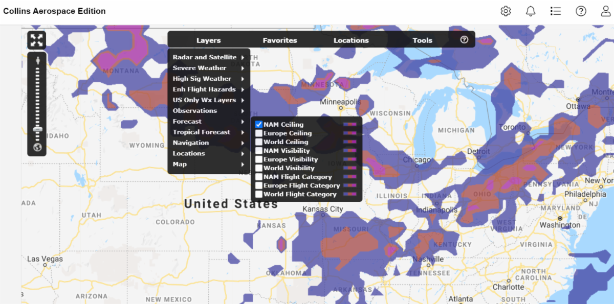
Our Graphical Weather Application located on the Weather tab, offers three different forecast products for fog forecasting. Hourly data, valid for 18-24 hours, is available for ceiling heights, visibility, and flight category (LIFR, IFR and MVFR) for North America, Europe, and Worldwide. These products give users the ability to view graphical forecasts in addition to TAFs.