Volume 57 | Tuesday, October 4, 2022

Jump Seat Logo _New_.png
small-Collins_Aerospace_logo_k_rgb.jpg

Operational Impact of Weather Events

Welcome back to Jump Seat. This week, with the latest tropical storm activity bringing weather to the forefront of our minds, we wanted to discuss the greater impact it has on business aviation. And perhaps more importantly, how can ARINCDirect’s tools and services help you prepare for potential hurdles brought about by weather and climate? 

Impactful Weather Events and Expert Resources


Having the right information goes a long way towards ensuring you are prepared for whatever Mother Nature has in store for us. Fog, thunderstorms, and tropical activity can put a damper on any plan but having a backup can help keep your mission on track.


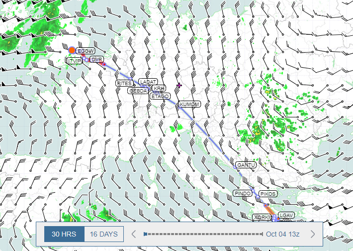
Preparing a secondary route can assist with a quick transition in case your primary option falls through due to weather constraints. For example, on a KTEB-KPBI flight plan, you can save multiple options on the Custom Routes section of the flight planning page to account for possible Flow Constrained Areas (FCAs) or forecasted weather. Saving options via inland corridors or offshore routes can allow you to change routes with ease, possibly leading to reduced delays.


The same approach can be made for destinations prone to fog like San Francisco (KSFO) or the London area airports. Identifying a backup airport can ease some of the worries that come with changing plans at the last minute. In the Bay Area, Oakland (KOAK) is a viable alternative when delays stack up due to fog at KSFO. Likewise, evaluating each of the London airports for fog probability can keep your plans on track if low ceilings and visibility threaten the metropolitan area.


Forecasting, particularly fog, can be tricky, and sometimes you need a helping hand. Fortunately, ARINCDirect's staffed meteorologists and dispatchers are subject matter experts on briefing operators about current or forecasted conditions, routing around storms, selecting the best alternates or Equal Time Points (ETPs), and mitigating delays. Our 24x7 Flight Operations team is available to assist via email at [email protected] or phone at +1 410-266-2266.


Tools to Make Informed Decisions


Accurate information and monitoring forecasted conditions is crucial as you prepare for inclement weather at your departure, destination, or en route. Monitoring forecasted conditions is the most proactive way and allows you to make informed, calculated decisions. Within the ARINCDirect tools there are several ways to get the information you need.


The Graphical Weather portal on the ARINCDirect website is home to additional products not available on the flight planning page. Access the portal via the menu on the Weather tab of your ARINCDirect account to take advantage of useful features such as:


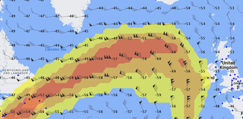
  • Temperatures Aloft – Select Winds Aloft from the High Sig Weather layer to assist with identifying warm pockets of air that can degrade aircraft performance.
  • Tropical Forecasts – this layer features a variety of additional tools such as official forecasted storm tracks and model guidance.

These two layers are just a small subset of the weather features available for you to explore on the Graphical Weather portal. The alerting functionality within the tool is another way you can remain up to date on the locations that matter most to you.


When creating , the embedded mapping tool is a useful way to see how your selected route compares to the weather. Toggling specific data sets on or off allows you to curate the information presented while gaining broader situational awareness.


Finally, the Eurocontrol Network Plan and FAA’s Planning, Execution, Review, Training, & Improvement (PERTI) Plan are both viewable on the Create FPL page when applicable to your departure or destination. Click on the link at the top of the Trip Details section, just above the Tail selection. Both documents, updated daily, provide additional information on forecasted weather and insight into planned traffic initiatives.

Improved Wind Data


Recently, our team upgraded the forecast wind data to provide the most accurate up-to-date wind information for enhanced flight planning. Forecast wind data is now available visually on the flight planning mapping tool out to 16 days. When the Winds Aloft layer is chosen within the Layers panel, the new time-based horizontal map slider will appear at the bottom of the mapping tool. 


For North American winds, hourly data is available out to 16 hours and 12-hour increments out to 16 days. For Global winds, hourly data is available out to 30 hours and 12-hour increments out to 16 days. 

Not only did our team temporally increase the wind data, but high-resolution wind data is also available spatially. There are five new flight levels available, as shown above.

Did you know?

  • The Graphical Weather portal is also available to users of the Izon platform. Just select the Aviation Sentry application to start accessing a wealth of weather tools!  

Useful Links

Here are some of our bookmarked sites that we recommend:


We love writing about weather and encourage you to read these past articles that may prove to be helpful over the coming months:


Thank you for reading!

Contact Us
Past Jump Seat Articles

Sign up for Izon, the Collins Connected Platform today!

Izon Setup Guide
https://collinsizon.com