Volume 73 | Thursday, June 1, 2023 | |
The 2023 Hurricane Season | |
|
Welcome back to Jump Seat. This week, we’ll review the disruptive 2022 Atlantic hurricane season, look forward to the upcoming 2023 season, and predict how this season might impact your operation.
The Atlantic hurricane season officially begins June 1st and will last through November 30th. With a significant amount of flight operations occurring throughout the Caribbean, Gulf of Mexico, and eastern coasts of the United States and Canada, it is important to stay aware of the potential for weather disruptions throughout the season.
| |
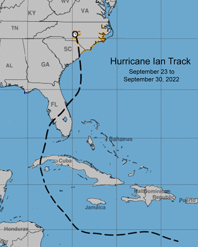
The 2022 hurricane season wrapped up with a total of fourteen named storms and was considered to be a below-average year. It might not sound like much, but nevertheless, these storms had lasting impacts. Hurricanes Ian, Fiona, and Nicole brought extensive damage to airports and other infrastructure while disrupting aircraft operations throughout Florida and Puerto Rico. Due to the extensive track of Hurricane Ian almost every state along the eastern seaboard felt some sort of impact from this devastating storm (Image 1). The east-central region of Florida experienced the most significant impact from Hurricane Ian, forcing many airports, including Tampa International Airport (KTPA), to completely close for several days. Substantial wind damage was felt, even hundreds of miles away from where Ian made landfall, and storm surges inundated coastal cities for a period of time. Rain was a huge factor even as Ian passed, creating flooding scenarios which lasted for days. Access to the airports that remained open was still difficult as many roads were deemed impassable. Even with proper planning, the unpredictable nature of storms such as Ian show us how easily operations can be disrupted. | |
Image 1: The National Weather Service created this graphic to show the length of Hurricane Ian’s track. This storm made not just one, but two landfalls in the United States. (Source: NWS Site) | |
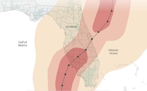
Image 2: Hurricane Ian’s wind field stretched hundreds of miles from its center (red- greater than 75 mph sustained winds, orange- 55-74 mph, yellow- 35-54 mph). Cross winds and clear air turbulence could present issues even if your operation is not close in proximity to a hurricane’s track (Source: USA Today) | |
Meteorologists analyze the environment around the storm to predict formation and movement of hurricanes. There are a number of conditions necessary for hurricanes to form with the primary ingredient being sea surface temperatures of 80°F (27°C) or greater. The second ingredient is minimal wind shear, which is the change in the wind speed and/or direction with height/distance. The presence of wind shear can tear a budding storm apart by disrupting its vorticity, essentially weakening it. Lastly, there must be an abundant supply of moisture in the atmosphere for the storm to continue to feed on. This moisture is primarily sourced from the aforementioned warm surface waters, or from an already water vapor-laden pocket of air. Hurricanes moving towards dry air (i.e., over land or desert areas) will tend to weaken. Friction with landmass, think mountainous terrain, will also greatly reduce its strength. These factors, along with forecasted upper level winds, will help meteorologists determine the hurricane’s track and intensity. | |
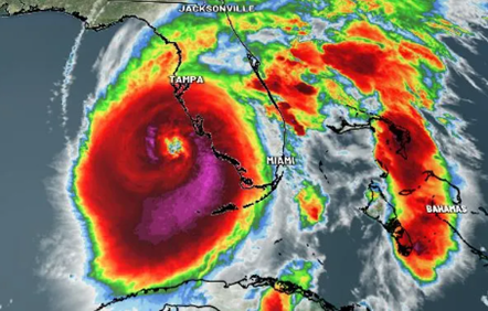
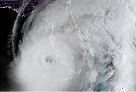
Images 3 and 4: Radar imagery (top) shows significant thunderstorms (darker red/purples) close to the eye of the storm. This will showcase intense rainfall and the strongest wind speeds. Similarly, hundreds of miles east of the eye towards the Bahamas, color contours show similar significant tops, demonstrating how being miles away from the center of the storm can still experience impacts. Satellite imagery (bottom) shows Hurricane Ian’s full extent. | |
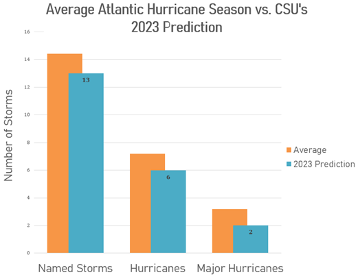
Each year, Colorado State University (CSU) publishes reputable hurricane season forecasts for named storms, hurricanes, and major hurricanes. For 2023, their forecast anticipates thirteen named storms, six hurricanes, and two major hurricanes. As these predictions are on par with the 2022 season, another below-average season is forecasted (Image 5). The primary factor as to why they believe it will be a below average hurricane season is because of the El Niño development later this summer. El Niño periods tend to create a presence of more wind shear in the Atlantic, along with a well-mixed layer for stability. | |
Image 5: CSU’s 2023 Atlantic Hurricane Season predicted number of storms for each strength category compared to the average values. | |
Along with the projected number of storms, CSU also provides their calculated probabilities of a major hurricane making landfall in specific regions. This year's percentages are slightly higher than average (Image 6) showing that they believe this year's forecasted upper-level winds are more likely to steer a major hurricane ashore. The takeaway from CSU’s forecast is that even though an average year is probable, there is a higher likelihood of a major hurricane making landfall. As always, proper planning and risk mitigation go a long way towards minimizing the disruptions from significant weather events. | 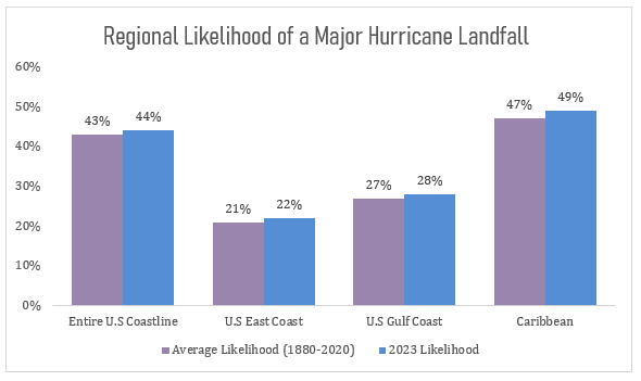 | |
Image 6: CSU expects that there is a higher probability of a major hurricane making landfall across all the regions they investigated.
Regardless of how active this season will be, regions like the Gulf of Mexico coastline, the Atlantic Routes (the ARs) off the coast of Carolinas, and the WATRS region (Atlantic waters between Bermuda and the US eastern coastline) will see some sort of significant tropical cyclones this season. Therefore, when planning for operations, a weather check is imperative. What to look out for? Surface low pressure systems that are generated off the western coast of the Saharan region typically can lead to significant storms. This is because there is little wind shear in that region, and there is plenty of warm water to fuel a storm’s growth. Likewise, low pressure systems over the Gulf of Mexico will also have easy access to the necessary factors for hurricane formation.
Hurricane forecasts could change as quickly as minute to minute. And sometimes, looking at weather maps, it is still difficult to discern where a hurricane can have its impacts. ARINCDirect's team of meteorologists and flight coordinators are ready 24x7 to assist you throughout this hurricane season.
| |
- In the northern hemisphere, the strongest region of a tropical cyclone is usually the right front quadrant. The reverse is true in the southern hemisphere, where the strongest region is usually the left front quadrant due to the reversed spin of tropical cyclones (the Coriolis effect).
- The deadliest aspects of a tropical cyclone are not the winds, but instead the storm surge and flooding. This is why even a tropical storm can cause a lot of devastation.
| |
|
Sign up for Izon today!
Izon offers a free, secure, single sign-on experience
that combines the best of ARINCDirect into
one connected platform.
| |
| | | |