Volume 115 | Tuesday, June 10, 2025

Jump Seat Logo _New_.png

The 2025 Hurricane Season

Welcome back to Jump Seat - the 2025 Atlantic Hurricane Season is upon us. Our team of meteorologists at ARINCDirect are here to guide you through the forecast, which most experts expect to be an average to slightly above average season, and what changes you can anticipate to forecasting products. 

2024 Atlantic Recap


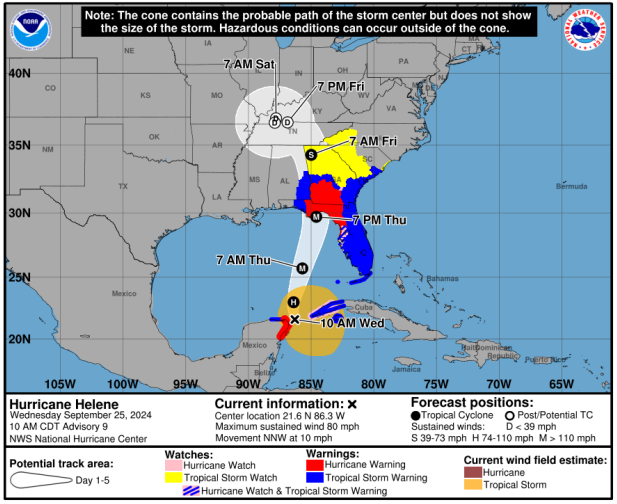
June 1st marked the start of meteorological summer in the Northern Hemisphere, as well as the first day of the Atlantic hurricane season. Reflecting on last year, 2024 was an active and above-average season with 18 named storms, 11 of which met hurricane criteria. If you recall, the season began with a series of back-to-back cyclones, followed by a lull in tropical activity before an uptick in September. 2024 was record-breaking thanks to the formation of Hurricane Beryl, which holds the title for the earliest Category 5 Atlantic hurricane on record, having made landfall on July 8th. Later in the season, Hurricane Helene – a Category 4 storm during its landfall across the Florida Gulf Coast region – brought catastrophic flooding and widespread damage through the southern Appalachians into North Carolina.  


While your operation may have been impacted by some of these storms, the Hurricane Hunters were actively operating reconnaissance missions aboard the fleet’s P-3 Orions and Gulfstream G-IVs. In total, researchers deployed over 1400 GPS dropsondes and hundreds of other meteorological instruments to obtain crucial air and sea data in the midst of these storms. It was hoped that the implementation of these new instruments would lead to forecast improvements for the 2025 hurricane season and beyond.  


Changes on the Horizon


Prior to 2024, the National Hurricane Center (NHC) and the National Weather Service (NWS) lacked the ability to issue storm surge, tropical storm, and hurricane watches and warnings on intermediate advisories impacting the United States. Instead, this was only possible for full or special advisories. For the 2024 season, this restriction was removed giving forecasters the necessary flexibility to provide critical updates on the intermediary advisories. 


The enhancement trend continues in 2025 with several new forecast products and features planned: 


  • The NHC, NWS, and Central Pacific Hurricane Center (CPHC) will now have the ability to issue tropical cyclone advisory products up to 72 hours before a potential tropical cyclone is expected to impact the forecast area. 
  • For the Atlantic Ocean, you can expect the track forecast error cone to be approximately 3-5% smaller compared to the 2024 cone. According to the NHC, “based on forecasts over the previous 5 years, the entire track of the tropical cyclone can be expected to remain within the cone roughly 60-70% of the time.”
  • Sustained hurricane-force wind radii will now be provided out to 72 hours, which is an increase from the 48 hours available in previous years.  


In addition to the aforementioned products, the NHC will update one of its experimental products to depict inland storm warnings and watches. The NHC expects this experimental cone graphic to typically be available within 30 minutes of the release of an advisory. More information regarding changes to this year’s products can be found on the NOAA website.  

(Image 1: Experimental Cone Graphic, courtesy of the NHC)


The Storm’s a-Comin'


Inevitably, you will often see an uptick in references to the terms El Niño or La Niña as the hurricane season approaches. The more technical term, El Niño - Southern Oscillation (ENSO), refers to the climatological variation in sea surface temperatures in the tropical portions of the Pacific Ocean. El Niño refers to periods of warming temperatures, while La Niña refers to cooler temperatures in the tropical Pacific. Though the terms reference conditions in the Pacific Ocean, their presence is inextricably linked to tropical storm development in the Atlantic Ocean. 


A La Niña period can favor an increase in Atlantic basin hurricane development as weaker vertical wind shear leads to conditions more conducive to storm development. During El Niño seasons, stronger vertical wind shear in the Atlantic basin can hinder the development of storms and generally lead to less active hurricane seasons for the North Atlantic region. For the 2025 Atlantic Hurricane Season, the potential impact from El Niño or La Niña appears to be minimal leading to average to slightly above average forecasts.  

(Image 2: 2025 Atlantic Tropical Cyclone names courtesy of the National Hurricane Center (NHC)

(Image 3: 2025 Hurricane Season Outlook courtesy of NOAA)


Each year, Colorado State University (CSU) publishes hurricane season forecasts for named storms, hurricanes, and major hurricanes. For 2025, their forecast anticipates 17 named storms, nine hurricanes, and four major hurricanes. Similarly, the National Oceanic and Atmospheric Administration (NOAA) has published its 2025 forecast, and they anticipate an above normal year with 13 to 19 named storms, six to ten hurricanes, with three to five becoming major hurricanes. 


Tropical weather forecasts can quickly evolve from hour to hour. Having the right resources and the backing of your ARINCDirect team of meteorologists and Flight Coordinators can help you safely weather the storm. 

Did You Know?

  • In April 2025, the World Meteorological Organization retired four names from being used to name storms. In the Atlantic, they are Beryl, Helene, and Milton, while in the Pacific John was retired. In their place, Brianna, Holly, and Miguel will be used for future Atlantic storms and Jake will be used in the Pacific. 
  • The Atlantic Hurricane Season runs from June 1st until November 30th.  
  • The NHC and NWS issue full advisories at 5 AM, 11 AM, 5 PM, and 11 PM EDT while intermediate advisories are published at 2 AM, 8 AM, 2 PM, and 8 PM EDT whenever coastal watches and warnings are in effect. 

Useful Links