Volume 130 | Monday, June 1, 2026 | | The 2026 Atlantic Hurricane Season | | Welcome back to JumpSeat. June 1st marks the official beginning of the Atlantic hurricane season and will run its course through the end of November. With the 2026 season kicking off today, we will cover the seasonal outlook, published by forecasters at the National Hurricane Center (NHC), which incorporates welcomed improvements to the forecasting toolbox. The ARINCDirect team of meteorologists have highlighted some of the significant changes to expect when forecasting this summer. | | |
A Review of the 2025 Atlantic Hurricane Season
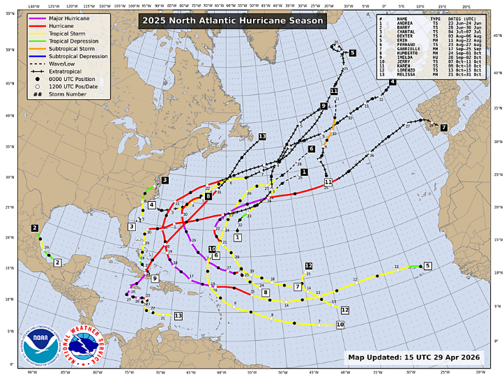
The 2025 Atlantic hurricane season concluded with a total of 13 named storms – four of which had reached major hurricane criteria (Category 3 or higher). Of these four storms, three reached Category 5 (winds 157+ mph), but thankfully remained far enough offshore of the Eastern Seaboard, limiting impacts to rough seas and minor coastal damage. If you cannot recall many storms from last year, that’s because no hurricanes made direct landfall across the continental United States. Tropical Storm Chantal (winds 40-74mph) had impacted the Carolinas in early July and brought excessive rainfall to the region, taking the title as the only cyclone that season to make landfall along the Continental United States (CONUS).
2025 also marked another monumental year for advanced forecasting capabilities. The team of NOAA Hurricane Hunters flew missions totaling over 400 flight hours, traversing the eyes of hurricanes over 50 times, and collecting data from over 1,000 dropsondes through the season. Real-time data from their reconnaissance missions is crucial to increasing the accuracy of tropical forecasting and storm predictions.
| | |
Image 1: Storm tracks from the 2025 North Atlantic hurricane season.
The 2026 Atlantic Basin Hurricane Outlook
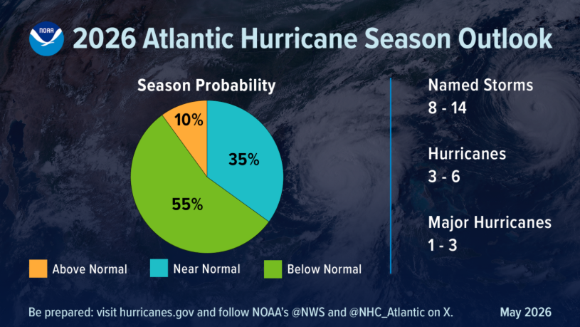
Meteorologists with NOAA’s National Weather Service (NWS) have finalized their Atlantic hurricane season predictions. Primarily based on global climate patterns, forecasters are anticipating the 2026 season to be below-normal. Thanks to El Niño and it’s strong, westerly winds aloft, tropical activity in the Atlantic typically has a more difficult time developing circulation and maintaining due to the ample vertical windshear. Meteorologists are still anticipating the potential for 8 to 14 named storms this season. As always, operators with interests across the Atlantic, Caribbean, and Gulf regions are urged to reference the latest discussions from the National Hurricane Center.
| | |
Image 2: NOAA’s 2026 Atlantic hurricane season outlook.
Changes to the NHC Forecasts
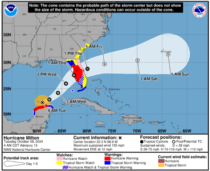
The National Hurricane Center (NHC) is expected to implement the latest version of the forecast cones that now include an inland extension of any tropical storm and hurricane watches and warnings. In years past, typical forecast cones only displayed tropical advisories spanning along the coastlines, leaving the potential for inland communities to undermine potential storm hazards. This latest amendment to the cone graphic was designed to better communicate the potential for storm criteria, timing, and impacts to those regions that lie within the NHC’s Track Forecast Cone.
| | |
Image 3: An experimental version of the latest cone graphics, simulated for 2024’s Hurricane Milton.
As Artificial Intelligence (AI) seeps into more and more aspects of our daily lives, hurricane forecasting presents itself as a perfect contender for operational improvements. Traditional Numerical Weather Prediction (NWP) models (think the GFS or ‘American’ and ECMWF or ‘Euro’ models) are computed with initial conditions – the actual, observed atmospheric data mainly taken from radiosondes and local weather stations – and thrown into complex, fluids and physics algorithms that output hundreds of meteorological parameters that make up our modern computer forecasts. What differentiates the latest AI Weather Prediction (AIWP) models from traditional Numerical Weather Prediction models is that AIWP takes the initial conditions and combines them with learned patterns and relationships to generate forecasts, as opposed to the mathematical and meteorological equations with the traditional models. One welcomed benefit of AIWP models is that they compute much faster than the traditional NWP super-computers, which can take upwards of 2-4 hours to generate model output.
For the 2026 hurricane season and beyond, you can likely expect a balance of traditional NWP and AIWP models as scientists continue to understand the pros and cons of AI’s implications to hurricane forecasting. Since the forecast models differ in their strategies, so too does their range of possibilities and uncertainty, which is where valuable meteorologist input comes into play.
| | |
Did You Know?
- In February of this year, the Hurricane Hunters flew well-ahead of the historic ‘Blizzard of ‘26’, which brought several feet of snow to the Northeast and New England. This mission took them over the Pacific, targeting the system days ahead of the storm’s development and impacts to the East Coast. As with the hurricane season, this data aids in fine-tuning the storm projection. Missions like these are relatively common across the Pacific Ocean during the North Atlantic’s off-season.
-
In addition to synoptic scale global models like the GFS and ECMWF, forecasters within the National Oceanic and Atmospheric Administration (NOAA) can initiate specialized, high-resolution models in the event of tropical cyclone activity. This next-generation model for hurricane forecasting is known as the Hurricane Analysis and Forecast System (HAFS) and was designed to improve projected cyclone intensity and track forecasts. What makes the HAFS so unique is its ability to forecast cyclone specific characteristics - rapid intensification, eyewall replacement, storm surge, and even tornadoes that can spawn from the hurricanes. The HAFS accounts for ocean-coupling, the method in Numerical Weather Prediction that dynamically links oceanic and atmospheric forecasts to model heat, moisture, and momentum transfers between the sea and the air.
- In the event of an anticipating landfall, the Air Traffic Control System Command Center (ATCSCC), in coordination with the National Weather Service (NWS) and other stakeholders, will often hold special 'Hurricane Telcons' to assess potential impacts to facilities in the path of the storm. It is at these briefings that FAA and state officials, airlines/operators, and meteorologists jointly discuss airpsace operations and preparations should any facilities need to be evacuated. As a member of the FAA's Collaborative Decision Making (CDM) initiative, ARINCDirect meteorologists often attend these Telcons in an effort to ensure your operations run smoothly.
| | | | |