|
Out with the Old, In with the New
In Spring of 2023, the FAA completed a milestone event by replacing numerous J-Routes with high level Q-routes, as a part of the National Airspace Modernization effort. These new Q-routes take advantage of GPS instead of ground-based systems that J-routes were reliant on. The new airways have been a long-planned initiative as part of a multi-step process to add, remove, and replace airways during recent Aeronautical Information Regulation and Control (AIRAC) or charting cycles. During this transition periods you may have also noticed that low level V-routes are being replaced with T-Routes, which are the low-level equivalent of Q-routes.
Industry Collaboration or ARINC + FAA = BFFs
Recently the ARINCDirect Flight Coordination (FC) team was invited to the FAA Air Traffic Control System Command Center (ATCSCC) and the Potomac Consolidated TRACON (PCT) in Warrenton, VA. The FC team had the opportunity to observe PCT controllers and learn more about traffic flows into the Washington D.C. metro airports. As part of the visit, the team was invited onto the floor of the FAA Command Center Control and given the opportunity to take a deeper dive into the implementation of national air traffic control flow programs. FCs also had time to ask questions of the controllers making these decisions daily.
Following the onsite visit to the FAA’s ATCSCC, the FC leadership team and flight planning subject matter experts met with an FAA Airspace & Procedures representative. This person specializes in airspace and procedures and played a significant role in east coast airspace redesign. The team spoke at length about how ARINCDirect and their users can help the National Airspace System (NAS) operate more efficiently and reduce both controller and pilot workload.
The key takeaways were:
- Random or optimized routing should not be used in the northeast to Florida corridor. Preferred routes should be filed at all times, or if not published, then you should file published routes for other city pairs as closely as possible.
- If you are anticipating a weather event, preferred routes or playbook routes should still be followed.
- Flight planners should know that ATC Cleared Routes don’t necessarily equate to “good” routes.
Preferred Routing are PREFERRED
Flight planning in the United States can be relatively easy compared to the complexities of oceanic and international travel. The FAA’s En Route Automation Modernization (ERAM) system will typically allow you to file any route, provided the airways and waypoints are valid. The ERAM system will process the flight plan and amend the route, if necessary, so that eventually the cleared route can be delivered to the crew. This differs from locations such as Eurocontrol where routes must pass validation before they are acknowledged and filed.
Throughout a large portion of the United States, namely less trafficked areas, optimized or random routing is possible to take advantage of favorable winds aloft or better weather conditions. The east coast corridor, however, is an exception to this rule. The FAA advised that the best practice for flight planning between airports in the northeast United States and Florida is to first and foremost, use preferred routes.
The FAA publishes preferred routes on their website and also works closely with service providers to communicate large scale airspace redesigns, such as we have seen in Florida as recently as last year. Finding a route is a simple as inputting a 3 letter IATA code if the airport is in the United States or there are stored routes for international locations such as Toronto (CYYZ) and Nassau (MYNN) using 4 letter ICAO identifiers.
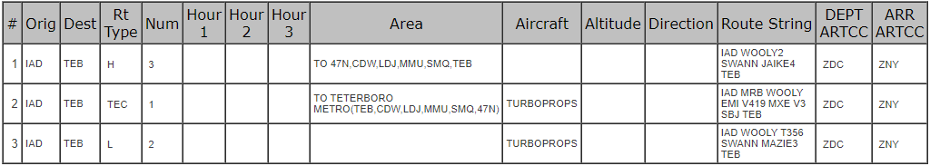
If a published route is available, ARINCDirect will display those as ATC Preferred along with additional information such as if the route is high level (H) or low level (L) or if the route is for Turboprops. Below you can see the routes presented on the flight planning page and how the FAA’s site displays them:
|