|
ALABAMA FLOODPLAIN
ADVISORY NEWSLETTER
| | |
Office of Water Resources | Floodplain Management Program December 2023 | Issue 23.03.01 | |
In This Issue:
- Alabama Floodplain Management Update & News
- FEMA News and Updates
- Association of State Floodplain Managers (ASFPM) News and Updates
- Other Federal Agency Updates on Flood Risk Management
| |
Alabama Floodplain Management Update & News | |
|
Note from the State NFIP Coordinator
Well folks, it has been quite a year and now it's time to close out 2023 and make plans for 2024. I've provided a brief summary below of the highlights from our work and activities in 2023. I have also included a listing of the training the we did in 2023 and what we are planning for 2024 so far. We will relaunch our Lunch & Learn Floodplain Management Series starting in January and with the plan for them to be conducted bi-monthly after that. We are working to line up speakers for the trainings for topics like how to prepare & review LOMRs/CLOMRs, how to leverage Risk MAP flood risk tools for development and mitigation, how to prepare & review No-Rise Certificates for floodway development, and how to administer your local floodplain development ordinance for compliance. If you have other topics that you are interested in learning about, please contact me at the email address below. More will be coming out shortly regarding how to sign up for the events.
Our ongoing objective is to partner with communities in their role to protect the health and safety of their citizens and to minimize the damage to private and public facilities from flood hazards. Therefore, we are committed to providing to our stakeholders continuing education opportunities, outreach and guidance resources, and technical assistance that address flood risk management. We recognize that local floodplain administrators play a pivotal role in ensuring the safety and sustainability of communities in flood-prone areas. That requires floodplain development to adhere strictly to ordinances because it's not just a bureaucratic formality; it's a crucial step toward mitigating risks, protecting lives and properties, and fostering sustainable growth. The new State Model Floodplain Development Ordinance was developed to help towards achieving that goal as are the training events we will be offering in 2024.
I look forward to seeing you at this coming at our training events and at the Alabama Association of Floodplain Administrators events. Also, Stephen and I are here to assist you with any program or technical assistance that we can. Please contact us as needed.
HAPPY NEW YEAR!!
-Corey
| | |
|
OWR's NFIP State Coordinating Office is committed to providing quality training events based on identified needs of the local Floodplain Administrators in Alabama. Here is a summary of the training provided in 2023.
- January 23 - 26: Huntsville; L-273 Class; Instructors - Mary Rountree/Nathan Lathrop/ Dewana Davis (FEMA Region 4), Corey Garyotis (ADECA-OWR)
- May 3 - 4: Montgomery; 2-day Community Rating System Workshop; Instructors - Amanda Gowans/ Garrett Byma (Verisk)
- May 31 & June 1: Birmingham & Foley; Substantial Damage Workshops; Instructor - Julius Lockhart (FEMA Region 4)
- October 11, 12, 25: Auburn, Spanish Fort, & Guntersville; Elevation Certificate Workshops; Instructor - Del Schwalls (Schwalls Consulting).
Alabama NFIP SCO has more training opportunities planned in 2024:
-
L-273 Class - January 29 - February 1, 2024; Montgomery, AL
-
Workshop on Rural Floodplain Management Strategies for Compliance - February 2024; Locations TBD
-
Lunch & Learn FPM Series - 4th Wednesday of every other month starting January 2024 (Jan, Mar, May, Jul, Sep, Nov)
-
Workshop on Substantial Damage Determinations & SD Local Plan Development - Dates & Locations TBD
-
CRS Workshop - Coordinating with FEMA for dates in 2024; Dates & Locations TBD
-
Coastal Construction Class - Coordinating with FEMA for dates in 2024; Dates & Locations TBD
-
Elevation Certificate Basics - Dates & Locations in 2024 TBD
-
Workshop on Strategies for Implementing a Local Flood Mitigation Program - Dates & Locations TBD
Look for the Alabama Association of Floodplain Managers Spring Workshops to be in April 2024. More information will be coming soon on the AAFM website at: www.aafmfloods.org. ###
| |
Highlights from 2023 for the State Coordination Office | |
The Alabama State NFIP Coordinating Office supports communities in implementing the regulations of the NFIP. Alabama partners with FEMA to evaluate local compliance with the NFIP and provide technical assistance to support communities in adopting, administering, and enforcing effective flood loss reduction standards for land use and development.
The State NFIP Office worked with other State agencies to implement programs that will reduce the risks, damages, and costs of flooding for public and private property owners. Staff spent a significant amount of time working with the Governor’s Office to develop an executive order (EO 737) that established the Department of Insurance as the agency designated for the Floodplain Administrator for State
(continued below)
| | |
|
(cont'd)
Property and ADECA as the agency designated for the State National Flood Insurance Program (NFIP) Coordinator. The State NFIP Office also worked with the Alabama Emergency Management Agency (AEMA) on its Hazard Mitigation Plan Update Task Force to provide technical and programmatic information relevant to the floodplain management and flood risk reduction activities in Alabama.
The State NFIP Office worked with federal, state, and local government officials further to provide an integrated approach to floodplain management in Alabama. It partnered with the Mobile and Nashville Districts of the U.S. Army Corps of Engineers to build on the efforts in 2022 to establish a Silver Jackets team in Alabama. The Silver Jackets Team, which consists of federal, state, and local officials, held multiple leadership meetings and three stakeholder meetings in 2023 to identify priorities and goals for the team. The Team also identified two potential projects for further assessment of flood risk and alternatives for implementing risk reduction measures.
| |
|
The NFIP Office initiated assessments of over 100 local floodplain management programs to determine the level of compliance in those programs. Follow-up conversations and correspondence are on-going for those assessments. In addition, the NFIP Office provided technical assistance to over 200 stakeholders (local officials, engineers, surveyors, property owners, realtors) in Alabama to address a variety of inquiries on floodplain management issues.
Part of the mission for the NFIP Office is to provide education and outreach to floodplain management stakeholders. Staff from the NFIP Office conducted six (6) training events in 2023 on a variety of topics to address the needs expressed by the local Floodplain Administrators. There were 190 participants total in the various trainings. State NFIP staff also participated in three Alabama Association of Floodplain Managers’ events and one Association of Floodplain Managers’ conference to gain new insights into new and updated programs and also to give technical presentations. ###
| |
 | |
Updated State Model Floodplain Development Ordinance
Alabama's new State Model Floodplain Development Ordinances (Coastal & Riverine) were finalized and issued to the 433 NFIP communities for revising their existing ordinances and adoption.
The Alabama Riverine and Coastal Model Ordinances were revised to more closely meet the NFIP minimum requirements for communities with identified flood hazards. It is not intended that these models, if adopted, will serve every community’s needs as related to floodplain management, land use, or zoning in Alabama. Communities are encouraged to evaluate and adopt standards that are more restrictive than the minimum NFIP regulations and this model ordinance includes optional language for higher standards for that purpose. The Model Ordinance provides many examples of higher standards that a community may use but it is recommended that the community’s attorney review any proposed changes to its ordinance to verify legality in its jurisdiction.
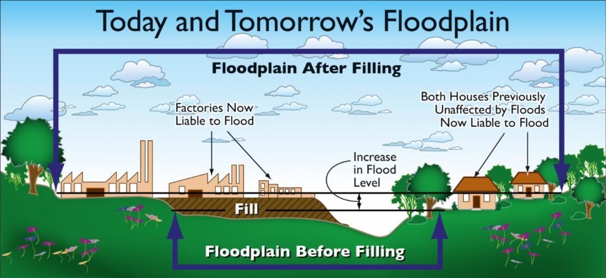
It's important to remember that development in the floodplain may result in adverse effects to the natural floodplain that can lead to the degradation and loss of natural functions and habitat. This degradation and loss can occur through clearing vegetation, placing fill, covering floodplains with impervious surfaces, rerouting stormwater, increasing pollution sources, and channelizing rivers. There are multiple benefits to naturally functioning floodplains that can be attributed to the resiliency of a community to the sometimes devastating effects of flooding. For that reason, FEMA encourages communities to limit development in floodplains to the greatest degree practical. In addition, as communities implement their floodplain management programs and make development and land use decisions, they must remember to comply with the Endangered Species Act (ESA). ###
| |  |
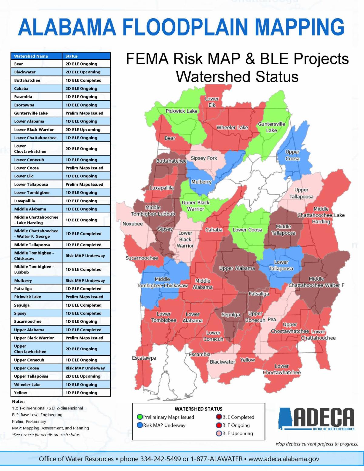 | |
ADECA’s OWR is responsible for implementing the Risk MAP program within the state. The Risk MAP program focuses on increasing flood risk awareness and resilience at the local level through effective community engagement and sustainable mitigation actions and the development of enhanced risk identification products, including watershed-based studies that cross political boundaries.
There are Risk MAP projects underway in Alabama in several watersheds throughout the state. In accordance with FEMA guidance, all watersheds within the State have been prioritized for study based on current flooding risk, the need for engineering updates, and the availability of quality topographic data, parcel data, and building footprints. Alabama’s FY23 Risk MAP Business Plan outlines the state’s plan to restudy various watersheds and build capabilities related to flood risk analysis. According to the plan, Alabama estimates that approximately 45% (2,328 miles) of existing AE Zones (detailed) studies are still in need of updated engineering to meet FEMA’s New, Validated, or Updated (NVUE) goals.
Across the state, over 20 base-level engineering (BLE) projects are complete or ongoing to update the Zone A modeling and more are already funded. Although these projects do not result in updated effective maps, they do produce updated models. These updated models can be used as “best available data” for the purposes of floodplain development, emergency management, mitigation planning, and economic development. There are a significant number of Zone A areas in Alabama that have BLE projects completed or underway and the water surface elevations available on the ADECA-OWR floodplain map website (www.alabamaflood.com).
There are five goals of the program: addressing flood hazard gaps, public awareness and outreach, hazard mitigation planning, an enhanced digital platform, and the alignment and synergies of risk analysis programs.
Casie Pritchard is the Risk MAP Program Manager. If you have any questions regarding the Program or flood maps in Alabama, please contact her using the contact information provided below. ###
| | |
|
Alabama NFIP Coordinating Office Contact Information
State NIFP Coordinator: Corey Garyotis | corey.garyotis@adeca.alabama.gov | (334) 353-0853
State NFIP Planner: Stephen Rodrigues | stephen.rodrigues@adeca.alabama.gov | (334) 353-2627
| |
|
Alabama Risk MAP & LOMR Contact Information
Risk MAP Program Manager: Casie Pritchard | casie.pritchard@adeca.alabama.gov | (334) 353-5061
Risk MAP Planner: Brian Pickering | brian.pickering@adeca.alabama.gov | (334) 353-1098
| |
FEMA Publishes Resources for Developing BRIC and FMA Grant Applications | |
On Oct. 12, FEMA announced $1.8 billion available in funding for the Fiscal Year 2023 Building Infrastructure and Communities (BRIC) and Flood Mitigation Assistance grant programs. The BRIC funding level will be $1 billion and the Flood Mitigation Assistance funding level will be $800 million.
FEMA published several program support materials and launched a series of webinars and on-demand videos that provide important resources and information for prospective applicants and sub-applicants. These resources can be used to help develop applications for these two FEMA hazard mitigation grants. The application period for both programs closes on Feb. 29, 2024.
These program support materials are resources to help state, local, tribal and territorial governments prepare applications for this grant cycle. The following program support materials are:
|  | Information about the Building Resilient Infrastructure and Communities and Flood Mitigation Assistance Funding Opportunities Webinar Series is available online and includes an opportunity to watch the video or download the presentation. This webinar provides an overview of and guidance on how to request Building Resilient Infrastructure and Communities Direct Technical Assistance in fiscal year 2023. More information about this opportunity is available on the BRIC Direct Technical Assistance webpage. Please complete this form by Feb. 29, 2024. ### | |
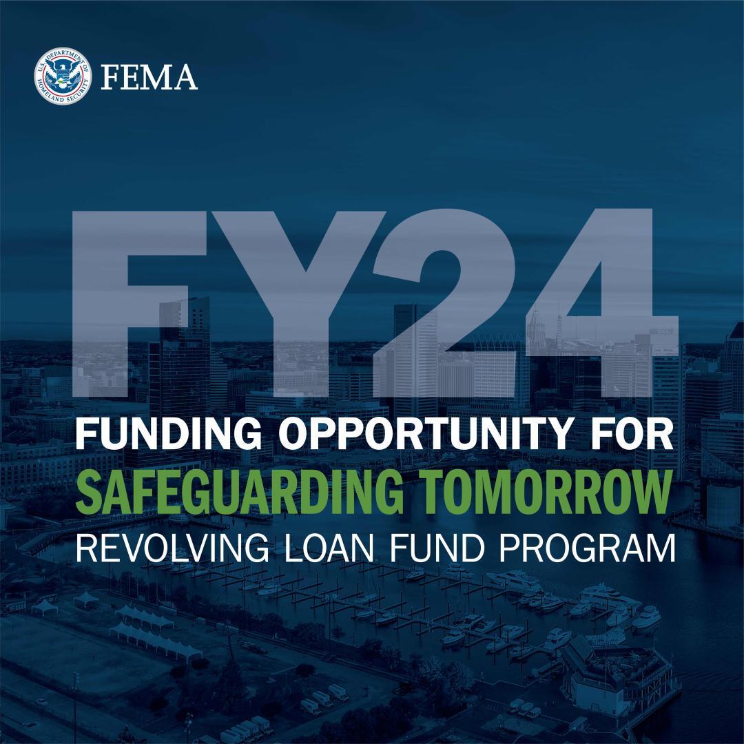
FEMA Announces $150 Million to Help Underserved Communities Receive Low-Interest Loans for Resilience Projects | |
As FEMA launches 2024 as its “Year of Resilience", the agency is announcing the second funding opportunity for the Safeguarding Tomorrow Revolving Loan Fund (RLF) grant program to make communities safer from natural hazards. This program, funded by the Bipartisan Infrastructure Law, provides capitalization grants to eligible applicants nationwide. Applicants then offer low-interest loans directly to local communities to reduce their vulnerability to disasters, promote equity, foster greater community resilience and reduce disaster impacts.
Due to the high level of interest in the first opportunity, the Biden-Harris Administration has tripled the amount of money available in this round of funding to $150 million.
The Safeguarding Tomorrow Revolving Loan Fund is part of FEMA’s Hazard Mitigation Assistance program. These grant programs help communities increase resilience to extreme heat waves, drought, wildfires, floods, and hurricanes by funding transformational projects that reduce risk to multiple hazards, support adaptation to future conditions, and reduce the impact of all disasters to our nation’s most at-risk, underserved and disadvantaged communities.
Applicants eligible to receive revolving loan capitalization grants include states, the District of Columbia, territories, and federally recognized tribes that have received a major disaster declaration. Local governments may use these low-interest loans provided by these entities for projects and activities to reduce the effects of natural hazards – including the many fueled by climate change.
|  | |
Revolving loans are intended to reach local governments most in need of financing assistance, including low-income geographic areas and underserved communities. FEMA encourages governments to take full advantage of the broad range of activities and projects eligible through this program and include mitigation measures that are not typically submitted under other programs.
For instance, the Safeguarding Tomorrow RLF is unique in that it is the only FEMA grant program under which extreme heat is explicitly eligible. The program allows applicants to use loan funds for projects or activities that reduce the impacts of drought and prolonged intense heat. FEMA will not require applicants to submit a benefit-cost analysis (BCA) for projects.
Additional eligible project types under this program include activities that mitigate the impact of natural hazards, zoning and land use planning changes, and adoption and enforcement of modern building codes. Loans may also be used by local governments to satisfy a local government’s non-federal cost-share requirement for other FEMA grant programs. ###
| | |
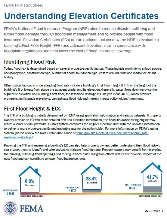
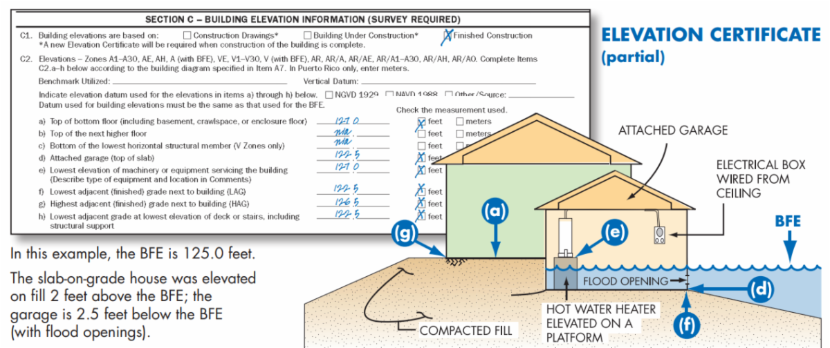
FEMA Updates the Elevation Certificate Form - | |
Today, flood risk is determined based on several property-specific factors. These include proximity to a flood source, occupancy type, construction type, number of floors, foundation type, cost to rebuild and flood insurance claims history. FEMA's website "Understanding Elevation Certificates" provides guidance on the various uses of an elevation certificate.
A community's permit file must have an official record that shows new buildings and substantial improvements in all identified Special Flood Hazard Areas (SFHAs)are properly elevated. This elevation information is needed to show compliance with the floodplain management ordinance. FEMA encourages communities to use the Elevation Certificate developed by FEMA to fulfill this requirement since it also can be used by the property owner to obtain flood insurance. Communities participating in the Community Rating System (CRS) are required to use the FEMA Online Elevation Certificate, FEMA Form FF-206-FY-22-152 (formerly 086-0-33).
FEMA has developed a Community Rating System training for Elevation Certificates on YouTube. The CRS EC training videos provide detailed instructions on how to complete the 2019 version of the EC. It covers the majority of what is needed to complete an EC while the 2022 instructions can fill in the rest. ###
| |
|
ASFPM's Annual Conference
Salt Lake City, UT | June 23 - 27, 2024
Join the Association of State Floodplain Managers (ASFPM) at the world's largest and most comprehensive floodplain management conference, June 23-27, 2024 in Salt Lake City, Utah.
This year marks our 48th annual conference, and over the years we’ve built a reputation for attracting top-notch speakers who deliver practical, field-tested content. There’s simply no better place to learn from industry experts who will provide you with the tools and insights to help you be more effective in your job.
As the nation’s premier conference dedicated to all aspects of flooding and floodplain management, you’ll find sessions on:
- Coastal Issues
- Dams & Levees
- Mapping
- Mitigation
- Modeling
- Natural & Beneficial Functions
- NFIP
- Post-Disaster
- Risk Communication
- Social Justice
- Stormwater & Urban Flooding
Go to the Conference Registration & Information Page
| |
| |
|
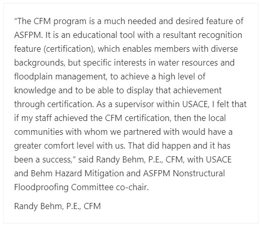
Certified Floodplain Manager "Bootcamp" Workshop
(Ref: ASFPM News & Views; December 15, 2023)
| ASFPM hosts a quarterly workshop for prospective CFMs who need more information about the program and how to become certified. The workshop a free, live virtual workshop for those interested in becoming a CFM or may have already applied to take the exam. The workshop is scheduled February 1, 2024 at 10:00 AM Central Time. Information and the link for the workshop can be found at ASFPM's Getting Certified under “CFM Bootcamp” after scrolling down through the “Exam Overview” section. ### | | |
Awareness is Key to Flood Mitigation in Your Community | |
The realm of floodplain management can be overwhelming to say the least. Many are new to this world or maybe just found out these duties are their responsibility. Having knowledge and tools readily available is essential to a successful program. It is important to have a foundation of awareness and the ability to extend that information to everyone in the community. One resource that provides great information for all community members can be found at ASFPM's Reduce Flood Risk website.
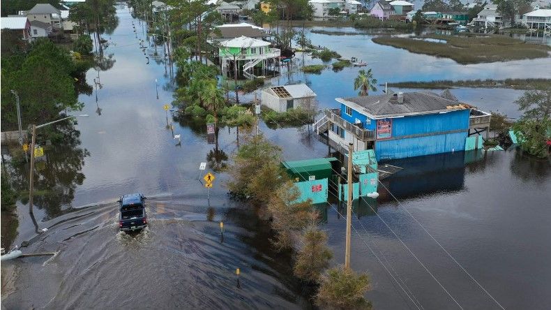
Flooding is the most common and widespread of all weather-related natural disasters. In order to protect the safety and security of local residents and infrastructure, communities must mitigate – or reduce flood risk – and determine how to respond when flooding occurs.
ReduceFloodRisk.org was developed by the Association of State Floodplain Managers to help property owners and buyers in flood prone areas identify strategies to reduce their property's risk of flooding. Flood losses have averaged nearly $17 billion per year between 1990 and 2018. With more than 1 million houses in the 100-year floodplain and given the rising frequency of flood events across the nation, it is vital that individuals and communities take action today to protect against future flooding tomorrow.
The website was also built to help local government officials:
- Explain flood mitigation to your residents as they work to reduce their individual risk, and
- Understand what actions your community can take to reduce its own risk of flooding and flood damages at the community level.
Additional information about the development of this new tool is available in a News & Views article from February 2023. ###
| |
|
Other Federal Agency Updates on Flood Risk Management | |
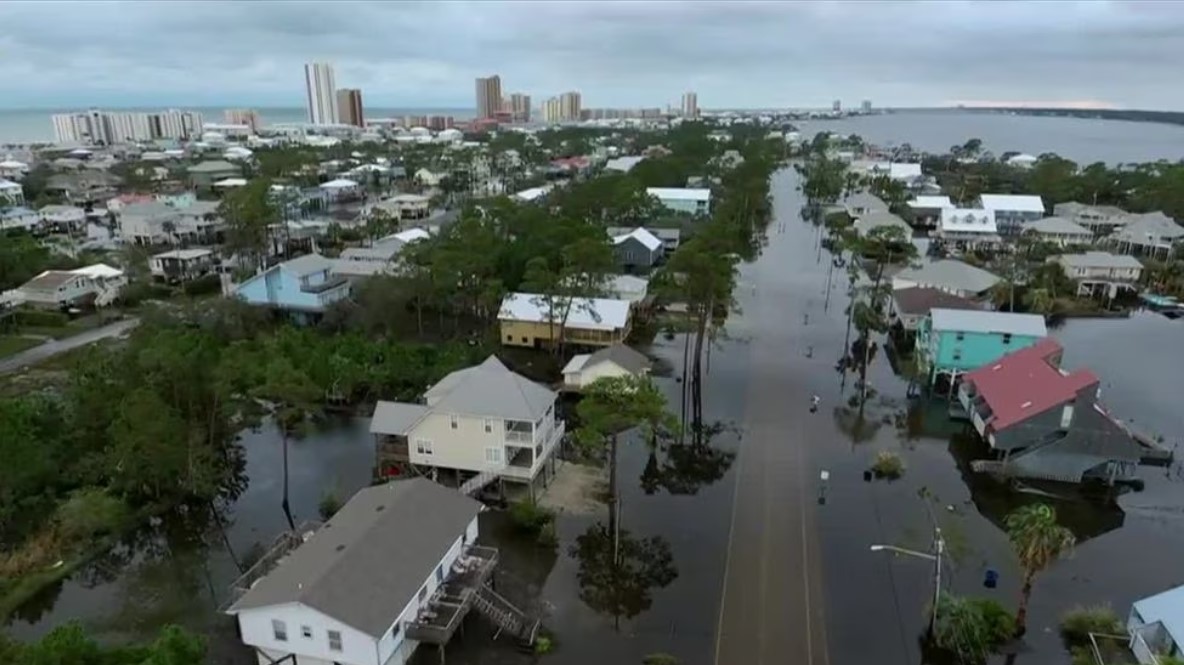
Alabama's Silver Jackets Program | |
The USACE supports state-led Silver Jackets Teams through its Flood Risk Management Program. Silver Jackets teams are interagency teams that facilitate collaborative solutions to state flood risk priorities. The state-led teams bring together multiple federal, state, regional, local, and sometimes tribal agencies to learn from one another and work together to reduce risk from floods and sometimes other natural disasters. By applying their shared knowledge, the teams enhance preparedness, mitigation, resilience, and response and recovery efforts. The state sets the priorities, with each agency member supporting the team using its own programs and resources within the constraints of available budgets and agency authorities.
The Alabama Silver Jackets team was reconstituted in 2022 and had its first three meetings within eight months of the team forming. The team plans to meet quarterly to discuss priorities, participate in training, and conduct project selection and planning. Its leadership is provided by the Flood Risk Management Program Managers from the USACE Mobile and Nashville Districts and the Alabama State NFIP Coordinator. The Alabama team provides a forum where all relevant federal, state, regional, and local agencies come together to collaboratively plan and implement interagency solutions. Through partnerships, the team will optimize the multi-agency utilization of federal resources by leveraging the resources, expertise, programs, and perspectives of multiple agencies which can result in more comprehensive and cohesive solutions for flood risk reduction activities.
The Alabama Silver Jackets team participants include state and local agencies with mission areas of hazard mitigation, emergency management, floodplain management, coastal management, building code enforcement, engineering, community planning, and natural resources conservation. Federal participation includes the USACE, Federal Emergency Management Agency, NOAA's National Weather Service and National Water Center, U.S. Geological Survey, as well as the Natural Resource Conservation Service, Environmental Protection Agency, among others. The team has reached out to others and hopes to have more participants from Tribes, academic institutions, regional planning commissions/councils, and non-governmental organizations.
Read More About Silver Jackets
| |
|
Industry Articles in Flood Risk Management | |
Newsletter Questions or Contributions:
For any questions about articles in this newsletter or about floodplain management and the NFIP in general, please contact Corey Garyotis using the email at the bottom of this newsletter. If you would like to write article or if you have an idea for a featured article in the newsletter, please contact Corey as well to discuss your idea.
|
| | | |