PacIOOS Tools and Instruments |
|
PacIOOS Pago Pago High Sea Level Forecast Back Online |
|
The PacIOOS Pago Pago High Sea Level Rise Forecast is not only back up and running, now that there is again real-time water level data coming from the NOAA water level station, but it is also improved with thresholds and examples of the impact of high sea level events. The Six-Day High Sea Level Forecast is a tool to predict higher than usual sea level at locations such as protected harbors and atoll lagoons. The forecast provides information that contributes to safe and reliable operations by harbor users, and provides a benefit to residential and commercial property owners in surrounding low-lying areas. To advance this forecast, the next step PacIOOS hopes to take is to translate this product into Samoan.
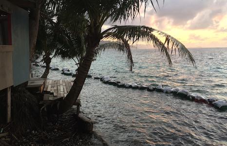
To submit photos of the impact of high water events, visit the Hawai‘i and Pacific Islands King Tides Project app. [Coastal erosion from early July's King Tides prompted landowner to create a breakwater. Credit: Kelley Anderson Tagarino via Hawai‘i and Pacific Islands King Tides Project] |
|
Hilo Wave Buoy Redeployed |
|
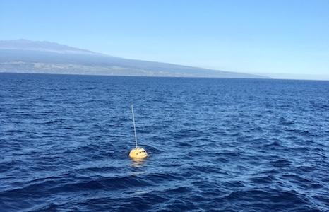
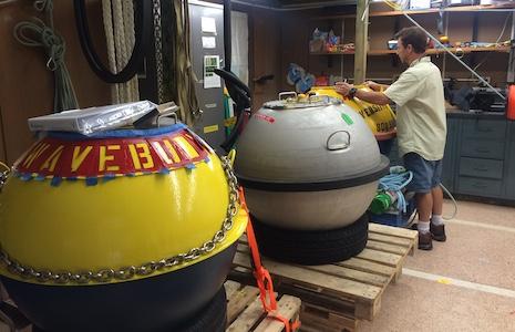
The PacIOOS wave buoy off Hilo, Hawaiʻi was redeployed this month. The wave buoy is located approximately 4 miles offshore of Leleiwi Point on the windward coast of Hawaiʻi Island. The buoy is part of PacIOOS' network of 15 real-time wave buoys across the U.S. Pacific Islands region, collecting information on wave height, period, and direction, as well as sea surface temperature. Data are transmitted in 30-min intervals to the PacIOOS website and PacIOOS Voyager. Information from this buoy promotes safe transit entering and exiting Hilo Harbor, offers real-time data to recreational ocean users, and provides critical information for coastal hazard and low-lying inundation forecasts.
The UH Hilo Marine Science Department rescued the buoy after a suspected shark bite weakened the mooring.The buoy was once again ocean-ready after refurbishment, cleaning, calibration, and communications tests by Coastal Data Information Program ( CDIP).
Huge Mahalo to the Makani 'Aha and Captain Kaino Hauanio for both the recovery and installation and Dr. John Burns for vessel support. Data management for the PacIOOS wave buoys is made possible through long-term partnerships with the U.S. Army Corps of Engineers and CDIP. [Photo: Hilo wave buoy with Hawaii Island in background. Credit: PacIOOS/ Kimball Millikan]
|
|
NSF Accelerator Funding to Improve Ocean Data Access for Indigenous Coastal Communities |
|
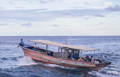
Through a new project funded by the National Science Foundation’s Convergence Accelerator program, PacIOOS is collaborating with partners in the Pacific Islands, the Pacific Northwest, and Alaska to improve access to ocean data for Indigenous coastal communities. The goal of the project is to get oceanographic data into the hands of communities in a way that takes advantage of existing, lower cost wave buoy technology and enables sustained community-led stewardship of the buoys. Through co-design, the team aims to revolutionize the status quo by providing new tools and new connections that will focus on the hyper-local scale.
The co-designed approach is in line with the focus of NSF’s Convergence Accelerator: advancing use-inspired solutions into practical application to address large-scale societal challenges. [Photo: Fishing boat in Majuro, Marshall Islands. Credit: Phil Welch]
|
|
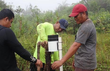
Conservation Society of Pohnpei recovers rain gauge |
|
Recently, the Conservation Society of Pohnpei ( CSP), in partnership with the Marine and Environmental Research Institute of Pohnpei ( MERIP), Micronesia Conservation Trust ( MCT), and PacIOOS, took on a mission to retrieve rain gauge data from Nahnalaud, the highest peak of Pohnpei, FSM. With PacIOOS funding and support, a rain gauge monitoring system has been installed where data will be collected every six months. The data will help determine the amount of rainfall on the mountains of Pohnpei. Results from this effort will help to track rainfall movement from the peak of the island into the lagoon where other sensors are monitoring salinity and turbidity. This will contribute to existing watershed and coral reef monitoring programs. We look forward to sharing the results on the PacIOOS website once analyzed. [Photo: Team retrieves rain gauge from highest peak in Pohnpei. Credit: CSP] |
|
PacIOOS is excited to welcome The Pacific Community (SPC) as a new Memorandum of Understanding (MOU) partner. Since 1947, SPC has proudly supported development in the Pacific region. Much of their focus is on major cross-cutting issues, such as climate change, disaster risk management, food security, gender equality, human rights, non-communicable diseases and youth employment.
Fully endorsed November 15, this MOU between two providers of ocean data and products serving the Pacific Islands encourages enhanced communication and will facilitate further joint ventures. Specifically, the MOU is envisioned to help maximize cooperation, eliminate undesirable duplication of effort, and ensure the efficient use of various technical personnel in order to address user needs. [Image: SPC logo]
|
|
Job Opening Coming Up: PacIOOS Wave Buoy Technician |
|
PacIOOS will soon start the recruitment process for a new PacIOOS Buoy Technician. The new hire will assist with the maintenance, fabrication and assembly of wave buoys, mooring, anchor systems and related equipment including maintenance of a 27-foot research boat, boat trailer, and lab truck in support of the PacIOOS Wave Buoy Program. In addition, the successful candidate will assist with maintenance of underwater instrumentation and provide field support for the installation, recovery, turnarounds and emergency buoy rescues for 15 buoy locations throughout the Pacific Islands. While the position will be based in Honolulu, travel throughout the Insular Pacific is anticipated. The position will be posted on the RCUH website soon. For more information, please contact Nicole Wakazuru-Yoza at nwakazur@hawaii.edu. [Photo: PacIOOS Wave Buoy Lab. Credit: PacIOOS] |
|
Funding Available for Dr. Nancy Foster Scholarship Program |
|
The NOAA Office of National Marine Sanctuaries is seeking applications for the Dr. Nancy Foster Scholarship Program from individuals, particularly women and minorities, who due to financial constraints, may not otherwise be able to pursue an advanced degree (Masters or Ph.D.) in oceanography, marine biology, maritime archaeology—these may include, but are not limited to ocean and/or coastal: engineering, social science, marine education, marine stewardship, cultural anthropology, and resource management disciplines.
The Scholarship covers tuition and a living stipend and travel funds will support a program collaboration at a national marine sanctuary field office or another NOAA office. The program includes training in science communication, stewardship, and how to become a national marine sanctuary ambassador. The deadline to apply is December 14, 2021. Learn more here. [Photo: Cordell Bank National Marine Sanctuary. Credit: Joe Hoyt/NOAA] |
|
Connecting with Pacific Islands Meteorologists |
|
Jennifer Strahl has been the lead meteorology instructor for the Pacific International Training Desk since 2014. Hosted jointly by NOAA and the University of Hawai‘i, the program focuses on building capacity and helping reduce disaster risk within Pacific meteorology services and the communities they serve. Weather observers and junior forecasters from the Pacific Islands region come together in Guam, American Samoa, and Hawai‘i for four-week in-person trainings (currently conducted virtually), to learn about introductory and intermediate meteorology concepts and forecasting techniques for both weather and waves.
Jennifer utilizes PacIOOS wave buoy data to demonstrate how weather couples with the ocean, and to validate wave forecast models with real-time observing data. Participants view wave model output and marine forecasts in PacIOOS Voyager, zooming into their islands of interest and stepping through the forecast to see arrival times and heights of forecasted swells. With a Master's degree in Meteorology, an interest in data visualizations, and nearly a decade worth of teaching secondary science, the Pacific Desk perfectly blends Jennifer's passions and skills. While often teaching about distant weather and ocean conditions, Jennifer truly enjoys connecting and engaging with the participants in hands-on, in-situ trainings across the Pacific Islands. [Photo: Jennifer (middle) and Pacific Desk participants from Kiribati and Tonga are training to observe coastal surf conditions at Makapu‘u, O‘ahu. Credit: J. Strahl] |
|
|
|
|
|
|