A March Meltdown: Historically Low Snowpack Melts Across the West, Signaling a Dire Water Supply Situation | | |
Key Points
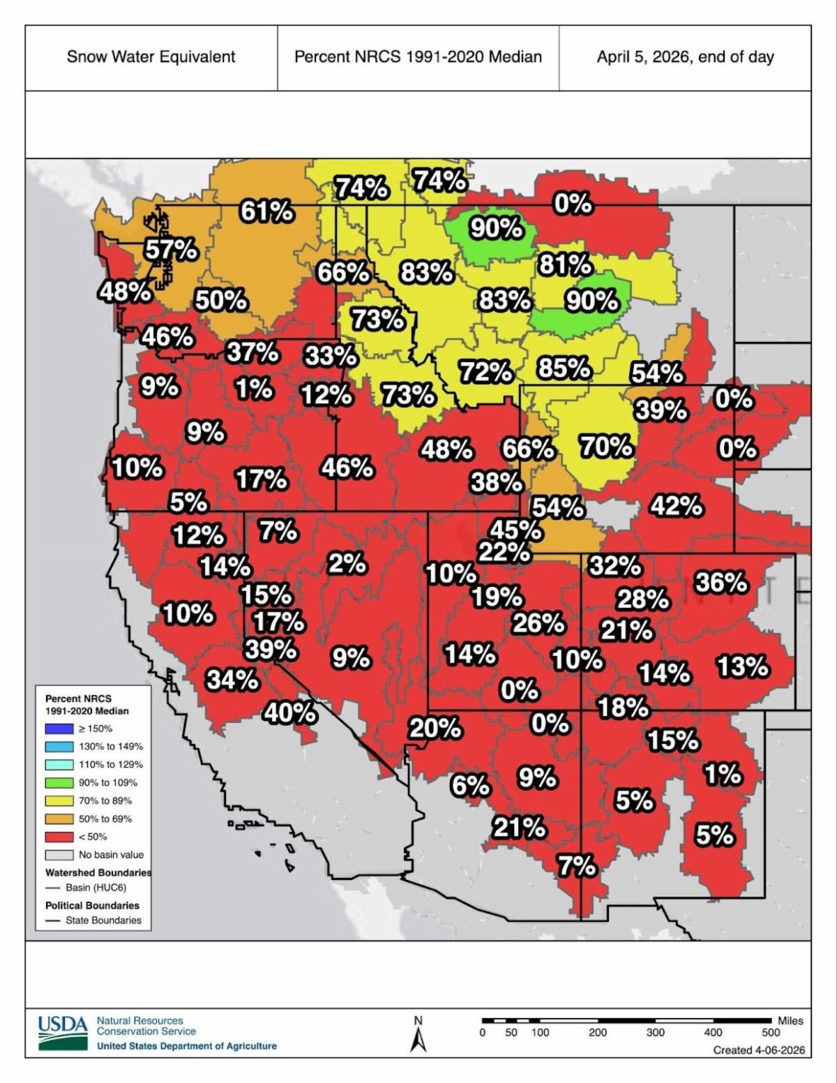
- Snowpack depth and water content typically peak around April 1, making the snow water equivalent (SWE, the amount of liquid water contained in the snowpack) on this date a primary indicator of spring runoff.
- This year, Arizona, Colorado, Idaho, Nevada, New Mexico, Oregon, Utah, and Wyoming all set new record-low April 1 SWE values since SNOTEL monitoring began in the 1980s. California recorded its second-lowest April 1 SWE value.
- Snow usually accumulates in March, but the record-shattering heat wave coupled with abnormally dry conditions led to rapid and early melting of an already historically low snowpack across most of the West. The exceptions are Washington and parts of Idaho and Montana.
- California River Basins experienced their driest March on record.
- The Colorado River Basin (Upper and Lower) experienced its warmest March on record, at 13.7°F warmer than normal.
-
According to SNOTEL observations, peak SWE across all Western states occurred an average of 21–34 days earlier than normal. Anomalies across some basins are larger. For example, SWE in the Upper Pecos and South Platte Rivers peaked 55 and 40 days earlier than normal, respectively. Only a few basins in the West reported a near-normal peak SWE date as of writing.
-
At many streamflow forecast points across the West, the probability of new record low spring and summer runoff volumes has increased. A majority of streamflow forecast points in the Colorado River Basin are forecast to produce less than 30% of average runoff.
- The effect of the low volumes may be especially pronounced in the greater Missouri and Mississippi River Basins, where multiple consecutive years of low water flows have disrupted navigation.
-
The Climate Prediction Center’s April–June outlook favors continued warmth across the West and dryness for parts of the region. Much of the West is entering into its climatologically warm and dry period, and any relief will depend on late spring storms and how active and widespread the monsoon season is. Drought conditions and impacts can be expected to deteriorate further.
- Many critical economic sectors like agriculture, energy production, and recreation have been or will be impacted this spring into summer. The worst impacts will likely be seen in parts of the the Pacific Northwest, Rio Grande Basin, and Colorado River Basin—areas that experienced consecutive years of droughts or snow droughts, and are starting the spring and summer with water storage deficits that are expected to worsen and further deplete.
The rest of this snow drought update is available online.
| |
For More Information, Please Contact:
Daniel McEvoy, Western Regional Climate Center
Daniel.McEvoy@dri.edu
Jason Gerlich, NOAA/NIDIS/CIRES Pacific Northwest Regional Drought Information Coordinator
Jason.Gerlich@noaa.gov
Tony Bergantino, Wyoming State Climate Office, University of Wyoming
antonius@uwyo.edu
Amanda Sheffield, NOAA/NIDIS/CIRES California/Nevada Regional Drought Information Coordinator
Amanda.Sheffield@noaa.gov
| NIDIS and its partners launched this snow drought effort in 2018 to provide data, maps, and tools for monitoring snow drought and its impacts as well as communicating the status of snow drought across the United States, including Alaska. Thank you to our partners for your continued support of this effort and review of these updates. | |
Forwarded This Email? Subscribe for Updates
Subscribe to the National Integrated Drought Information System's regional newsletters to receive webinar updates and other drought news for your area. Or, subscribe to NIDIS's bi-weekly newsletter, Dry Times, to receive national news, drought research, and events.
| | NIDIS is an interagency program within the Climate Program Office, which is part of NOAA's Office of Oceanic and Atmospheric Research. | | | | |