Greetings from the Coastal Resilience Team!
This month's newsletter contains:
- Lake Michigan Water Level Update
-
Resource of the Month: USACE Monthly Bulletin of Great Lakes Water Levels
-
Blog: Case Study: Milwaukee County Coastal Resources Inventory
-
Community Story: Cuyahoga County Seeks Public Input to Increase Public Access to Shoreline
-
Funding Opportunity: National Coastal Resilience Fund
-
Funding Opportunity: Great Lakes Sediment and Nutrient Reduction Program
-
Event: 2021 Great Lakes Sediment Management Workshop
-
Event: Spring Planning and Zoning Webinar Series
-
Survey: Coastal Management Needs for Local Governments On the Great Lakes and St. Lawrence River
|
|
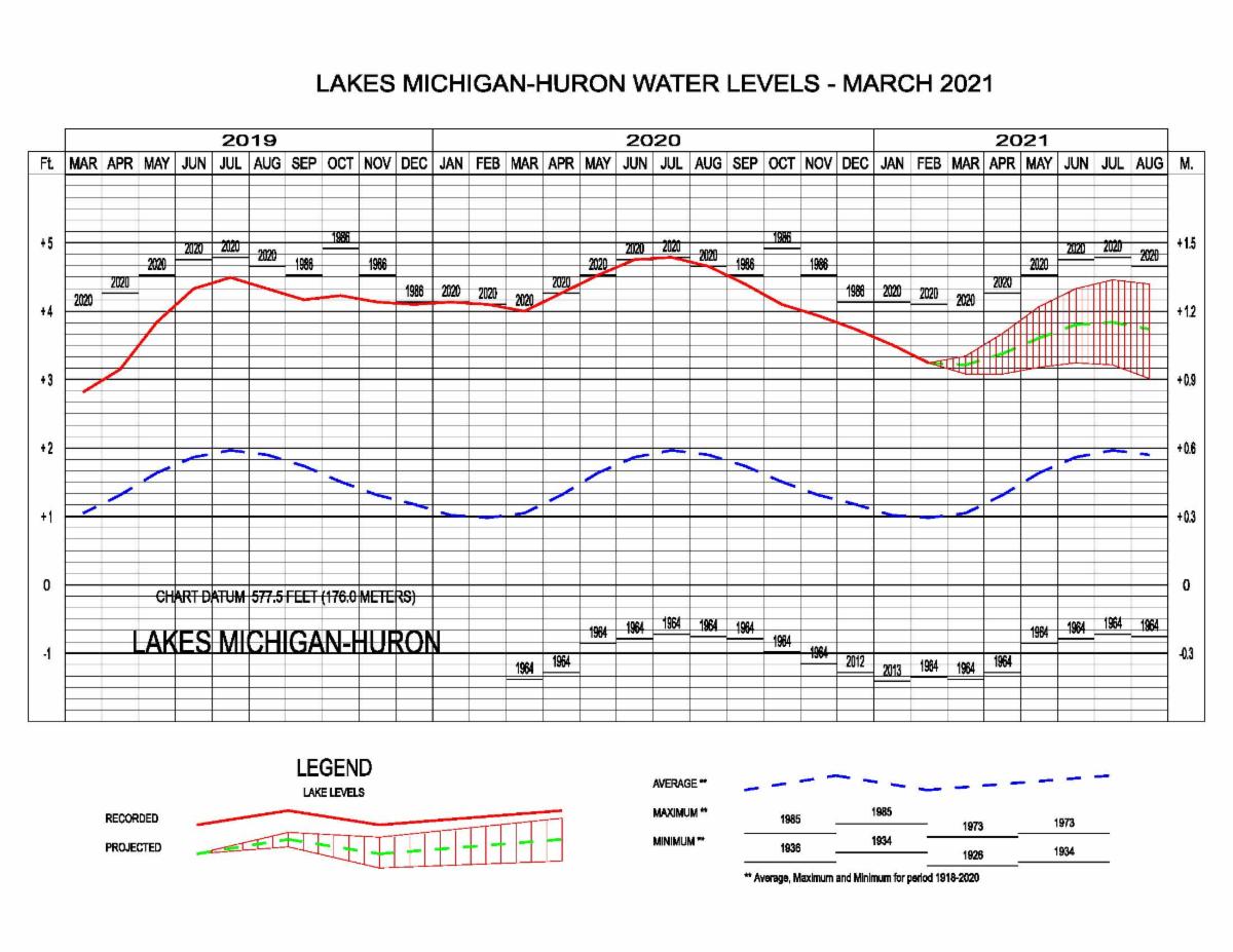
The water levels on all the Great Lakes have continued to be below their monthly record highs as of March 5, 2021. Lake Michigan is now 9 inches below the highest recorded monthly average in March previously set just last year in 2020. This is the second month this year where NBS has been below average. Lake Michigan is expected to resume its seasonal rise over the next two months. It is predicted that Lake Michigan-Huron will rise about 2 inches by this same time next month.
Check out these five things to know about water levels on Lake Michigan for March 2021.
|
|
USACE Monthly Bulletin of Great Lakes Water Levels |
|
The Monthly Bulletin of Great Lakes Water Levels depicts the recorded Lake levels from previous and current years, a projection for the next six months, lows, averages, and extreme lake levels from 1918 to 2020. While this information is not recommended for use in design decisions or long-term planning, a background knowledge of Great Lakes water levels can help understand the annual cycle of lake levels in addition to monthly patterns and variability before gathering supplementary data. |
|
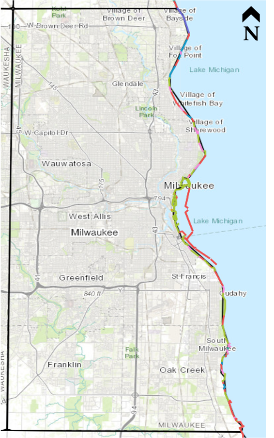
Case Study: Milwaukee County Coastal Resources Inventory
|
Milwaukee County has developed a comprehensive analysis and inventory of County-owned coastal resources. The goal of this analysis is to ultimately form a plan for coastal hazards that is preventative instead of reactive to changing Lake conditions. The project inventoried coastal resources along Milwaukee County’s Lake Michigan coast, summarized their current status, assigned economic values to those resources, and prioritized them according to vulnerability and value. The five different components to the project included an asset inventory, condition assessment, vulnerability assessment, asset valuation, and risk score. Click the button below to learn more!
|
|
Coastal Resilience Stories from Around the Great Lakes |
|
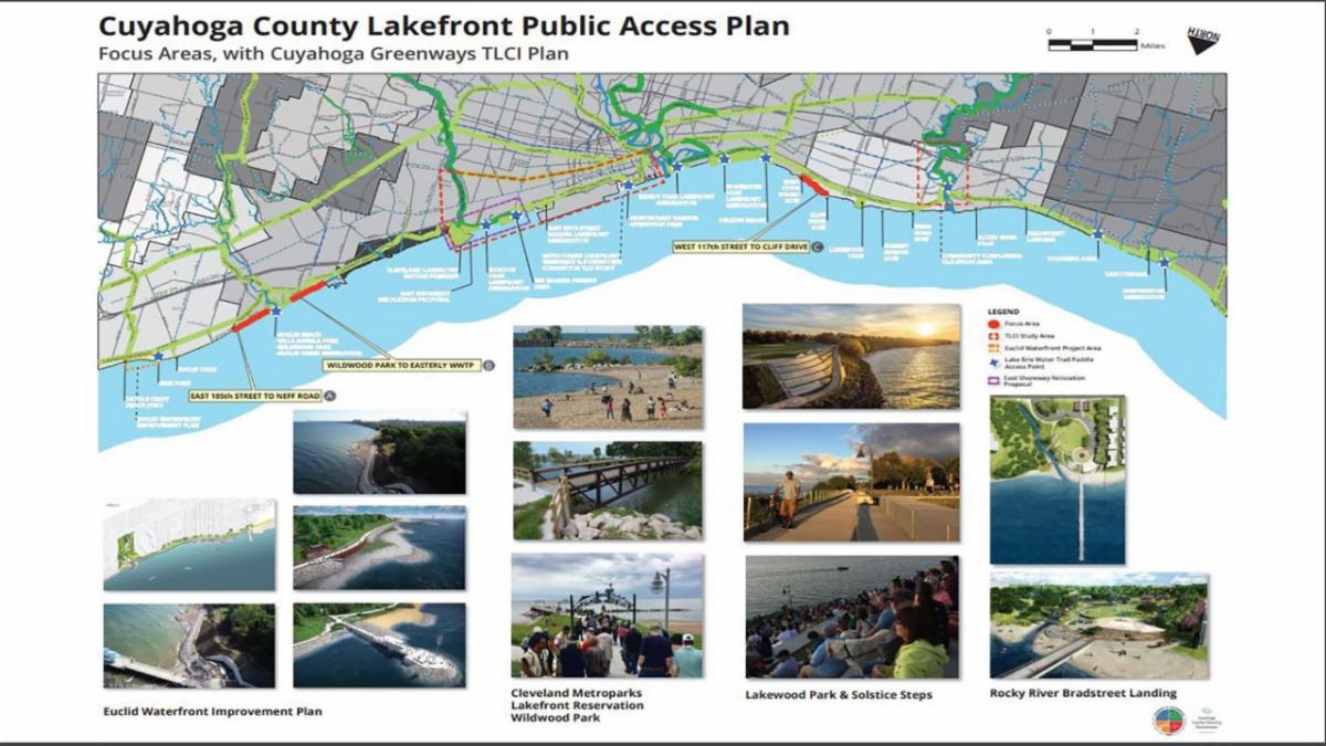
Cuyahoga County Seeks Public Input to Increase Public Access to Shoreline |
|
In Cuyahoga County, OH, currently, 90% of the Lake Erie shoreline is private property and inaccessible to the public. Through the Lakefront Public Access Plan, the county aims to open 30 miles of shoreline focusing on "properties, roads and other infrastructure, and develop a network of interconnected bridges, roads, trails, boardwalks and paths...". One of the issues the County is looking to mitigate is discontent from lakeside property owners. So they have included a robust public engagement campaign involving online surveys, public meetings, and other forms of public engagement. |
|
Image of Cuyahoga public survey |
|
National Coastal Resilience Fund |
|
The National Coastal Resilience Fund is seeking pre-proposals for grant funding due April 7. Administered by the National Fish and Wildlife Foundation, the National Coastal Resilience Fund restores, increases and strengthens natural infrastructure to protect coastal communities while also enhancing habitats for fish and wildlife. Priority areas for funding include Community Capacity Building and Planning, Site Assessment and Preliminary Design, Final Design and Permitting, and Restoration and Monitoring. This year the fund will invest approximately $33 million in these projects, including multiple awards between $1 million to $5 million to fund implementation and construction under the Restoration and Monitoring priority area.
|
|
Great Lakes Sediment and Nutrient Reduction Program |
|
The Great Lakes Sediment and Nutrient Reduction Program is seeking grant funding proposal applications due 4:00 p.m. CST on April 16. This year’s program will focus on helping nonfederal units of government, tribes, or incorporated nonprofit organizations reduce phosphorus contributions to waters within the Great Lakes basin and other efforts. Applicants are invited to submit proposals for sediment and nutrient reduction activities associated with one of three project types: 1) agricultural non-point; 2) stormwater; and 3) Great Lakes shoreline or streambanks. Final decisions on funded projects are anticipated in summer 2021. Selected projects would begin on October 1, 2021 (with potential for an earlier start) and maybe up to three years in duration. For more information, contact Nicole Zacharda at [email protected] or 734-971-9135.
|
|
2021 Great Lakes Sediment Management Workshop |
|
This free workshop will occur as a series of 4 webinars, one every Tuesday, throughout the month of April. It is being planned in collaboration with the Great Lakes Regional Sediment Management Team, comprised of the U.S. Army Corps of Engineers, U.S. EPA, USGS, USDA-NRCS, and other partners. Contact Ken Gibbons ([email protected]) for further questions.
Schedule:
Each webinar starts at 1:00 PM (CST)
|
|
The Center for Land Use Education is offering a Spring webinar series designed for planning and zoning staff and new and continuing officials to learn about their roles and responsibilities related to zoning and subdivision regulations. All presentations are recorded. Registrants have access to the recording and session materials. Send questions to [email protected].
Schedule:
Tuesday, March, 16th (10-11 AM): Shoreland Zoning
Thursday, April 8th (1-2 PM): Subdivision Regulations
Thursday, April 29th (10-11 AM): Zoning Fundamentals
Tuesday, May 18th (1-2 PM): Meeting and Hearing Conduct
|
|
Survey on Coastal Management Needs |
|
The Great Lakes and St. Lawrence Cities Initiative
is surveying local elected officials and staff
to help guide future coastal protection efforts
Survey Purpose
The Great Lakes and St. Lawrence Cities Initiative and its partners are assessing needs facing U.S. and Canadian local and tribal governments on the Great Lakes and St. Lawrence River related to coastal management and resilience to impacts such as erosion from changing water levels, flooding, and severe storm events. The survey results will guide efforts to help communities safeguard resources in coastal areas.
Who Should Complete the Survey
The survey is intended for both elected officials and staff in local units of government, as well as Tribal Authorities and First Nations.
Time Commitment
The survey should require approximately 15 minutes to complete. You do not need to complete it in one sitting.
Response Deadline
Please complete the survey by Friday, April 30.
For More Information
If you have questions or would like to receive a summary of the survey results, please contact Jon Altenberg, Executive Director, Great Lakes and St. Lawrence Cities Initiative, [email protected].
|
|
If you have any questions about Lake Michigan coastal hazards or how to approach, plan, and prepare for them, please contact
Adam Bechle
608-263-5133
For more information, visit the Southeast Wisconsin Coastal Resilience Project website or the Northeast Wisconsin Coastal Resilience Study portal
Follow us on Twitter @sewiresilience for updates
|
|
University of Wisconsin Sea Grant Institute | (608) 262-0905 | 1975 Willow Drive, 2nd Floor, Madison, WI 53706
|
|
|
|
|
|
|