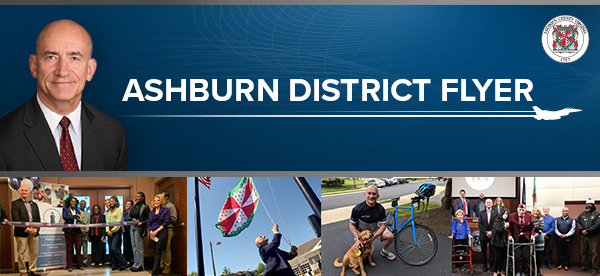
Monday, September 25, 2023 |
|
Updates to County Wide Improvements
- Loudoun County Courthouse Complex Expansion
- Philip Bolen Memorial Park - Phase II Improvements
- Bus Shelter Program
-
Bus Stop Installation for New Routes
Active & Planned Projects in the Ashburn District
Facilities
- Ashburn Recreation Center
Intersection Improvement Program (IIP)
- Claiborne Parkway and Marshfield Drive
- Ashburn Road and Faulkner Parkway
- Claiborne Parkway and Dulles Greenway
- Waxpool Road and Ashburn Road
- Ashburn Farm Parkway and Golden Meadow Circle/Summerwood Circle
Roadway Improvements & Maintenance
- Crosswalk at Winkle Drive and Nightwatch Street
- Farmwell Road Intersection Improvements
- 2023 Paving and Slurry Projects
- Evergreen Mills Road / Revolution Sportsplex – Westbound Left-Turn Lane
- Ryan Road Widening - Evergreen Mills Road to Beaverdam Drive
Sidewalks, Trails and Shared Use Paths
- River Creek Parkway Sidewalk
- Beaverdam Run Trail
- Waxpool Corridor Pedestrian Improvements
- Ashburn Village Blvd (Farmwell Road to Michener Drive)
- Metro Station Area Pedestrian Improvements
- Traffic Study of Ashburn Road from Gloucester Parkway to Ashburn Farm Parkway/Farmwell Road
- Sidewalk Study: Ashburn Road from the W&OD Trail to Gloucester Parkway
Parks
- Ashburn Park
- Trailside Park
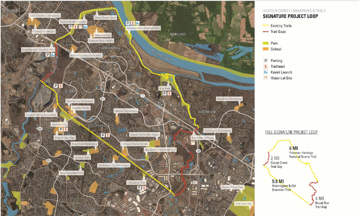
- Countywide Linear Parks & Trails (LPAT) System
- LPAT Signature Project
Approved Land Applications and Developments
(Progressing Toward/In the Building Phase)
- National Conference Center East
- Ashburn Chase & Regency at Belmont Chase Townhomes
- Goose Creek East
- Waxpool Crossing
- Belmont Executive Plaza
- Belmont Park
- Belmont Automobile Service Station
Legislative Applications for
Development in the Ashburn District
Significant By-Right Developments
in the Ashburn District
|
|
Greetings Ashburn!
While work on the ongoing Zoning Ordinance Rewrite (ZOR) has been encouraging, it has also been all consuming. So, I am pleased to take a brief break to provide a comprehensive update to the many planned projects and active developments happening in and around the Ashburn District.
The goal of this community infrastructure update is to provide an overview of projects as they move along the multiple planning and implementation phases. I am happy to announce that work on the Court House Complex Expansion and Improvements to Philip Bolen Memorial Park are nearing completion.
Additionally, I am excited to highlight six projects that are new to our community infrastructure flyer. This includes construction of a missing sidewalk segment along River Creek Parkway, roadway improvements along Evergreen Mills Road, Ryan Road, and at the intersection of Ashburn Farm Parkway and Golden Meadow Circle/Summerwood Circle, as well as two projects to strengthen and expand Loudoun’s transit system: the “Bus Shelter Program” and the “Bus Stop Installation for New Routes” program.
The recent progress expands the scope of what is possible in Loudoun County and is a true testament to the diligence of county staff, the determination of community stakeholders, the importance of citizen input and the strength of the Loudoun community. This is truly an exciting time to be in Loudoun and everyone has a role to play in shaping our community.
In the big picture, the current chapter in our journey as a county will prove to be vital for bringing our community together, fostering a sense of belonging and strengthening Loudoun’s growing role in the region. The responsibility of all Loudouners is to continuously make systematic and incremental improvements to the world around us. This is just one reason why my staff and I feel that it is important to keep you in the loop as community projects move forward.
Please don’t hesitate to contact me directly or my staff with any input and ideas you may have for the Ashburn District.
Warm regards,
Mike Turner
Ashburn District Supervisor
|
|
Updates to Countywide Facilities |
|
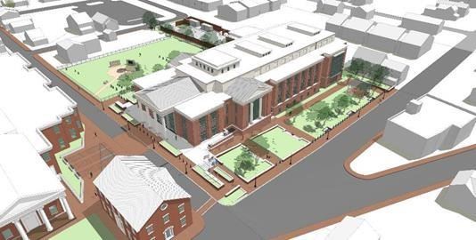
Loudoun County Court Complex Expansion |
|
Location: The Court House Complex Expansion is in downtown Leesburg at the corner of Church Street and Edwards Ferry Road on the current Church Street Parking Lot.
Description: Construction of a new 92,000 square foot Loudoun County District Courthouse, renovations of existing courthouse (18 East Market Street) and Valley Bank building (20 East Market Street) and new parking facilities. Parking lots and pedestrian access to the court buildings will also be improved.
Estimated Project Timeline:
- Construction of the new courthouse is expected to be complete in summer 2023.
-
A ribbon cutting ceremony is scheduled for October 25th, 2023 at 5:30pm.
Update: Significant progress on the new courthouse has been made in recent months. Installation of interior drywall, door frames and window glazing are complete on all levels. Permanent power for the new building has been established, and crews have installed the elevators and are painting interior walls.
-
Previous Update: In Summer 2022, the building was made watertight, and the installation of interior drywall partitions began and remains ongoing. Mechanical, electrical, and plumbing work within the building also remains ongoing. Additionally, work on the tunnel and dry utility relocations around the Courthouse continues. In the beginning of 2023, the completion of the tunnel structure and dry utility relocations around the Courthouse is expected. This will allow for permanent power to the new Courthouse, which will be followed by the start-up and commissioning of mechanical and electrical systems. Additionally, completion of interior drywall partitions is expected, with the installation of ceilings, flooring and other building finishes beginning.
Visitors to the Loudoun County Courthouse may park for free at the Pennington Garage and Pennington Lot, which are located approximately two blocks away off Church Street NE in Leesburg. Shuttle service from the Pennington Garage and Pennington Lot to the courthouse will run approximately every ten minutes, Monday through Friday from 7:30 a.m. - 5:30 p.m. A walking path between the parking areas and the courthouse will be maintained throughout the duration of construction. View parking details and a map of the shuttle route and walking path in this flyer (PDF).
|
|
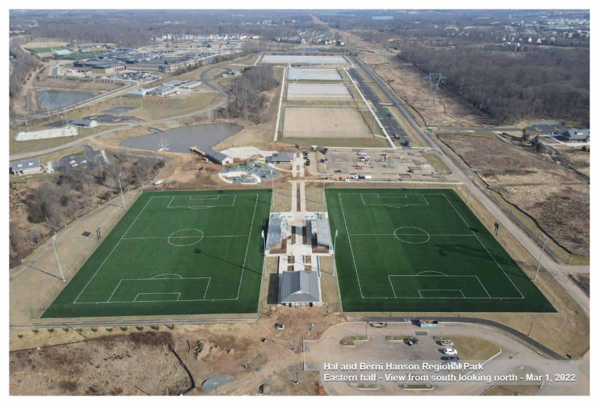
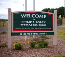
Philip A. Bolen Memorial Park Phase II Improvements |
|
Description: This project provides funding to design four permanent restrooms and concession facilities in FY 2021. Funding was allocated in FY 2021 for construction, removing a large existing dirt stockpile on the property and developing two practice fields with associated parking.
Estimated Project Timeline:
- Substantial completion of this project is expected in Fall 2023.
Update: In this quarter, the installation of interior and exterior finishes continued, as did the installation of mechanical, electrical, and plumbing systems. In the next quarter, all installations are expected to be complete, tested, commissioned, and the project is expected to achieve Substantial Completion.
-
Previous Update: The installation of underground utilities and foundations continued, as did the installation of precast. Additionally, the installation of doors, windows, and mechanical equipment began.
|
|
Description: This project provides funding for the design and construction of 20 bus shelters along the local fixed-route bus routes per year with a three-year production schedule from commencement to completion.
Project Timeline by Fiscal Year (FY):
- Design: FY 2024 - FY 2028
- Land Acquisition: FY 2025 - FY 2028
- Construction: FY 2026 - FY 2028
- Estimated Completion: FY 2031
|
|
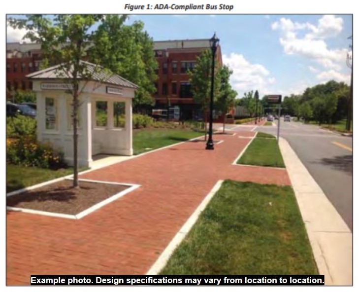
Bus Stop Installation for New Routes |
|
Description: This project provides funding for the construction of bus stops for a maximum of two new routes annually. Each route will consist of approximately 30 ADA accessible bus stops.
Estimated Timeline by Fiscal Year (FY):
- Construction: FY 2024 - FY 2028
- Estimated Completion: Ongoing
|
|
Active & Planned Projects in the Ashburn District |
|
Loudoun County is continuously working to improve every corner of the greater Loudoun community. While we would love to write about every project in Loudoun County, the goal of this newsletter is to inform Ashburn District residents about developments and planned improvements occurring within the Ashburn District. However, for the sake of relevancy, we decided to write about only a select handful of key improvements located outside of the Ashburn District.
The remainder of this newsletter is dedicated to developments and planned improvements which are located entirely or at least partially in the Ashburn District.
To learn more about projects occurring elsewhere throughout Loudoun County, we invite you to check out any of the following resources:
|
|
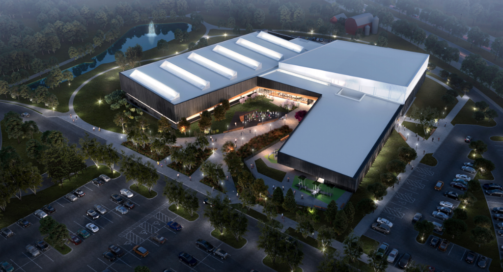
Ashburn Recreation and Community Center |
|
Location: Broadlands Boulevard, between Claiborne and Belmont Ridge Road.
Description: 117,000 square feet double story complex that includes a 50-meter competition pool, leisure pool, spa, teaching/catering kitchen, playroom, gymnasium classrooms, meeting rooms, office, and more fitness facilities. There will also be a multi-use trail surrounding the center, a courtyard with seating, a splash play area, and playground equipment.
Estimated Project Timeline:
- This project is currently in the construction phase and is scheduled to be substantially completed in Summer 2025.
Update: In this quarter, structural steel erection was completed, as were the installation of the building's slab-on grades. Additionally, the installation of the building's exterior envelope, construction of the competition pool, and the rough-in of mechanical, electrical, and plumbing systems began. In the next quarter, installation of the building's exterior envelope, construction of the competition pool, and the rough-in of mechanical, electrical, and plumbing systems are expected to continue. In the next quarter, installation of the building's exterior envelope, construction of the competition pool, and the rough-in of mechanical, electrical, and plumbing systems are expected to continue.
-
Previous Update: In this quarter, the installation of underground utilities and building foundations continued and the installation of structural steel began. In the next quarter, building foundations are expected to be completed, and the installation of underground and structural steel will continue.
|
|
Intersection Improvement Program (IIP) |
|
Description: The Intersection Improvement Program provides for a long-term process to systematically address safety and capacity challenges at roadway intersections throughout Loudoun County. This process includes an analysis of intersections resulting in a prioritization that considers the frequency of accidents and traffic volumes. From the list of ranked intersections, a group of highest priority intersections are selected for further detailed traffic safety analysis resulting in recommended improvements for each studied intersection. At the October 18, 2022 BOS Business Meeting, the Board directed staff to proceed with detailed traffic studies of 19 intersections identified in the 2022 Intersection Improvement Program Study, a ranking study of more than 900 non-signalized, signalized, and roundabout intersections. The ranking and selection process follows a regular cyclical schedule for the remaining intersections. Funding for planning, design, land acquisition, and construction of improvements for prioritized intersection projects is determined by the Board of Supervisors, during its annual budget deliberations.
Project Timeline by Fiscal Year (FY):
- Estimated Completion: Ongoing/Indefinite
Update: In this quarter, traffic analysis studies continued for the remaining 15 intersections identified in the 2022 Intersection Program Study. Additional improvements for the intersection of Belmont Ridge Road and Creighton Road are being identified through the Belmont Ridge Road Corridor Study. In the next quarter, future conditions will be reviewed for the 15 intersections.
Learn more (Quarterly Report/Capital Improvement Projects, 4th Quarter, FY 2023 – Page 91 of the PDF. The project name is "Intersection Improvement Program")
Learn more (FY 2024 Adopted Budget - Volume II, Page 280 of the PDF. The project name is " Intersection Improvement Program")
|
|
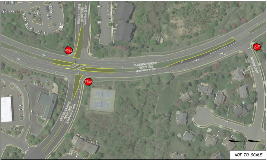
Claiborne Parkway and Marshfield Drive |
|
Description: Provides for the conversion of the intersection to a right-in, right-out, left-in configuration and the addition of a U-turn Lane on the northbound approach of the Claiborne Parkway/Wayside Court intersection.
Project Timeline by Fiscal Year (FY):
- Design: FY 2024
- Land Acquisition: FY 2024
- Construction: FY 2025
- Estimated Completion: FY 2026
Update: In this quarter, the design team created a public information webpage and worked to finalize the 100% design plans. In the next quarter, the design team will review 100% plan comments and initiate plat preparation for acquisition of right of way and easements. The design team is working on a recorded public information presentation to be posted on the County’s project website. The last plan submission was sent to VDOT for review.
-
Previous Update: In this quarter, the design team addressed 30% plan review comments and completed 60% design plans. In the next quarter, the design team will submit 90% design plans.
|
|
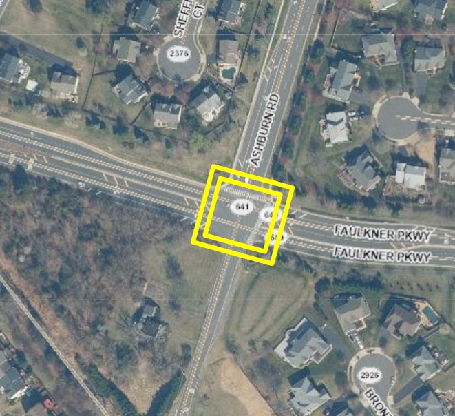
Ashburn Road and Faulkner Parkway |
|
Description: This project provides for the installation of a traffic signal at the intersection of Ashburn Road and Faulkner Parkway. Additionally, it provides for the creation of dedicated right and left-turn lanes in the east and westbound directions and vertical profile improvements along Faulkner Parkway, including the addition of alternative turn lane configuration analysis.
Project Timeline by Fiscal Year (FY):
- Design: FY 2024
- Construction: FY 2026 - FY 2027
- Estimated Completion: FY 2027
Update: In this quarter, 100% design plans were submitted for multi-agency review on May 11, 2023. In the next quarter, responses to comments from 100% design plans will be prepared and plans for right of way and easement plats will be developed. A utility field inspection will be scheduled.
-
Previous Update: In this quarter, the 30% design plans were submitted for multi-agency review. In the next quarter, responses to comments from the 30% design plans will be prepared and the 90% design plans will be developed. Due to the addition of the alternative turn lane configuration analysis to the scope, the design phase completion has been moved from spring 2023 to fall 2023.
|
|
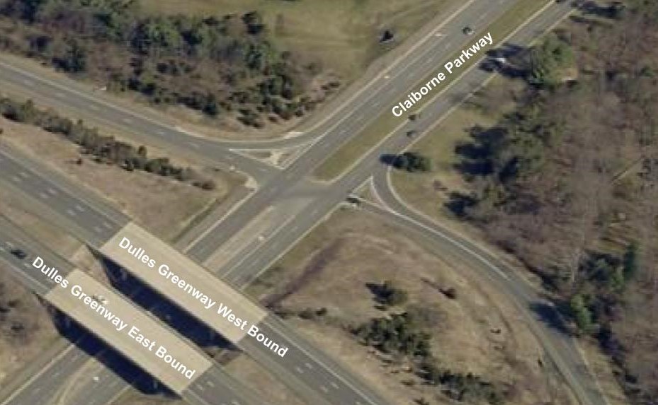
Claiborne Parkway and Dulles Greenway |
|
Description: VDOT initiated the design of this traffic signal project in FY 2022 utilizing VDOT funds and transferred plans to the County for completion and implementation. Provides for the installation of a traffic signal and upgraded ADA-compliant pedestrian ramps at the intersection while retaining existing lane configurations.
Project Timeline by Fiscal Year (FY):
- Design: FY 2024
- Construction: FY 2026
- Estimated Completion: FY 2027
Update: In this quarter, DTCI procured engineering services under an existing task order contract to complete the plans. DTCI also met with Dulles Greenway (TRIP II) and VDOT to discuss proposed design concepts. In the next quarter, the DTCI design team will submit formal 60%/90% design plans for multi-agency review. DTCI will coordinate proposed changes with TRIP II.
-
Previous Update: VDOT initiated the design of this traffic signal project in FY 2022 utilizing VDOT funds. In this quarter, the VDOT design team submitted 30% design plans for Loudoun County and VDOT Land Development design review. DTCI is coordinating review comments and transfer of the project from VDOT to DTCI.
|
|
Waxpool Road and Ashburn Road |
|
Description: As a product of the traffic analysis and safety study of Waxpool Road between Faulkner Parkway and Demott Drive, The Board of Supervisors approved recommendations to design improvements at the intersection of Waxpool Road and Ashburn Road/Ryan Corner Place. The recommended intersection improvements include interim and long-term improvements.
Interim Improvements: Install all way stop signs and use pavement markings to expand the existing left-turn lanes on Waxpool Road to provide one shared left/through lane and one shared through/right lane on each approach on Waxpool Road. This will alleviate the sight distance problems and assign right-of-way for all vehicle movements, which will diminish the crash patterns at this intersection. Completed in Summer 2022.
Long-Term Improvements: Installation of a traffic signal.
Estimated Timeline:
- Work estimated to span FY 2021 - FY 2026
- Utility Relocation is estimated to be complete in Summer 2024
- Project is estimated to be complete in FY 2026
Update: In this quarter, Comcast initiated the relocation of their lines in preparation for the project. The design team updated plats for submission to B&D. In the next quarter, utility relocation will continue and the design team will address B&D plat comments.
-
Previous Update: In this quarter, the contractor completed the interim intersection improvements at Waxpool Road and Ashburn Road. The design team also initiated the design of the signal pole foundations and utility coordination in preparation for the long-term improvements. In the next quarter, the design team will finalize utility coordination.
|
|
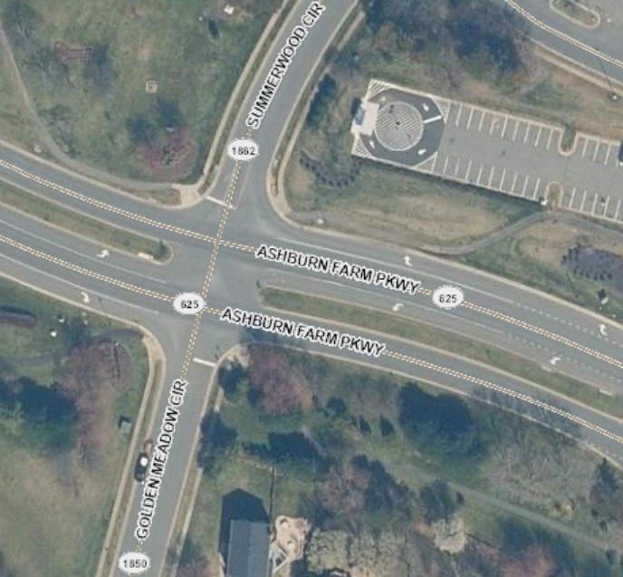
Ashburn Farm Parkway and
Golden Meadow Circle/Summerwood Circle
|
|
Description: At the October 18th, 2022 Board of Supervisors Business Meeting, an action item titled "Intersection Improvement Program Update" came to the Board with recommendations to advance this intersection, and 18 other intersections, to the Capital Improvement Program for prioritization within the IIP.
Project Timeline by Fiscal Year (FY):
- Work estimated to span FY 2025 - FY 2029
- Estimated Completion: FY 2029
Update: At the October 18th, BOS Business Meeting, the Board voted unanimously to advance the Ranking 5 intersections, as identified in the 2022 Intersection Improvement Program Study (Round 3), to the Capital Improvement Program. DTCI will report back to the Board on the results of the advanced safety studies, including recommended viable safety improvements, at a future business meeting. Through the advanced safety study process preliminary cost estimates will be developed for each recommended improvement and will be used to program the recommended intersection improvements into the FY 2025 budget
Learn more (Intersection Improvement Program Update)
|
|
Roadway Improvements & Maintenance |
|
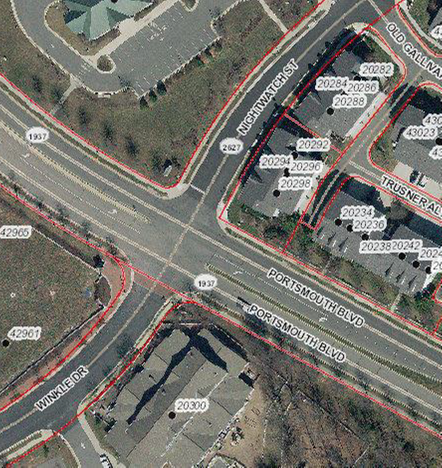
Crosswalk at Winkle Drive and Nightwatch Street |
|
Location: At the intersection of Portsmouth Boulevard and Winkle Drive/Nightwatch Street.
Description: Installation of a crosswalk over Portsmouth Boulevard to improve pedestrian connectivity between Winkle Drive and Nightwatch Street
Estimated Project Timeline:
Land acquisition is estimated to be completed in winter 2024 with construction to follow shortly after.
Update: Design has been completed and the project is entering the land acquisition phase.
-
Previous Update: The crosswalk design has been approved. Staff from multiple county departments are working to secure land rights in the northeast corner of the intersection to construct the curb ramp and make it eligible for VDOT maintenance.
|
|
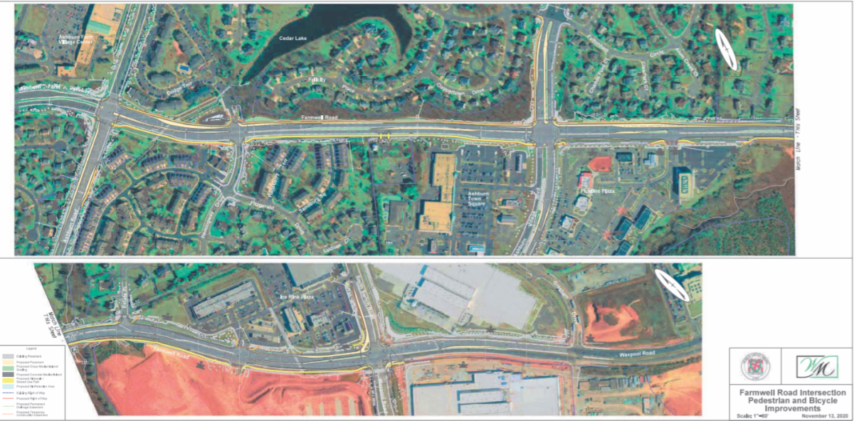
Farmwell Road Intersection Improvements |
|
Location: Farmwell Road, between Smith Switch Road and Ashburn Road.
Description: Installation of improvements along Farmwell Road to create safer conditions for drivers, bikers, and pedestrians. The current project scope includes the addition and/or modification of turn lanes and receiving lanes at several Farmwell Road intersections, including Farmwell Road and Ashburn Road, Farmwell Road at Dodge Terrace, Farmwell Road at Ashburn Village Boulevard and Waxpool Road/Farmwell Road at Smith Switch Road. Pedestrian improvements and connectivity along the corridor are also part of the project scope.
Estimated Timeline:
- Fall 2023: Design Completion
- Fall 2023 - Summer 2024: Right of Way
- Summer 2024 - Winter 2025: Utilities Relocation
- Winter 2025 - Spring 2025: Procurement of Construction Contractor
- Spring 2025: Award Contract – Construction
- Spring 2025: Notice to Proceed – Construction
- Spring 2025 - Fall 2026: Construction
- Fall 2026: Substantial Completion
Update: In this quarter, the design team submitted the 100% design plans to B&D and VDOT. Utility coordination continued. In the next quarter, the design team will address 100% design plans and prepare plats in preparation for land acquisition. Additional time will be necessary to process and complete plats extending the Design Phase from spring 2023 to fall 2023.
-
Previous Update: In this quarter, final plans and estimates are being prepared by utility providers as the design team continues to develop 100% plan. In the next quarter, the design team will finalize development of 100% design plans.
Learn more (Quarterly Report/Capital Improvement Projects, 4th Quarter, FY 2023 - Page 27 of the PDF. The project name is "Farmwell Road Intersection Improvements").
|
|
2023 Paving and Slurry Projects |
|
Description: To repave or apply a slurry seal to existing roadways where needed. (Slurry seal is a mix of asphalt emulsion and aggregate that is spread over the entire roadway surface. It is applied by a truck equipped with a squeegee or spreader box).
Update: In the Ashburn District, repaving/resurfacing has occurred or will occur on the following roads:
To be complete in 2023:
- Capilano Court
- Lohengrin Court
- Medinah Court
- Partlow Road
- Preddy Court
- Tolamac Drive
|
|
Complete:
- Ashburn Farm Parkway
- Ashburn Village Boulevard
- Belmont Ridge Road
- Bold Forbes Court
- Bonnieblue Court
- Breeders Run Court
- Broadlands Boulevard
- Charter Oak Drive
- Melanie Court
- Chesterton Street
- Christiana Drive
- Churchill Downs Drive
- Claiborne Parkway
- Deer Chase Place
- Fincastle Drive
- Genuine Reward Court
- Loudoun County Parkway
|
|
Complete
- Maplegrove Court
- Mintwood Court
- Needlepine Court
- Pimlico Way
- Portsmouth Boulevard
- Riverside Parkway
- Saratoga Court
- Secretariat Court
- Silverthistle Court
- Tara Court
- Triple Crown Court,
- Hollywood Park Place
- Twelve Oaks Way
- Waxpool Road
- Woodridge Parkway
- Yellowbloom Court
- Gloucester Parkway
|
|
Click here for more information on VDOT's progress.
|
|
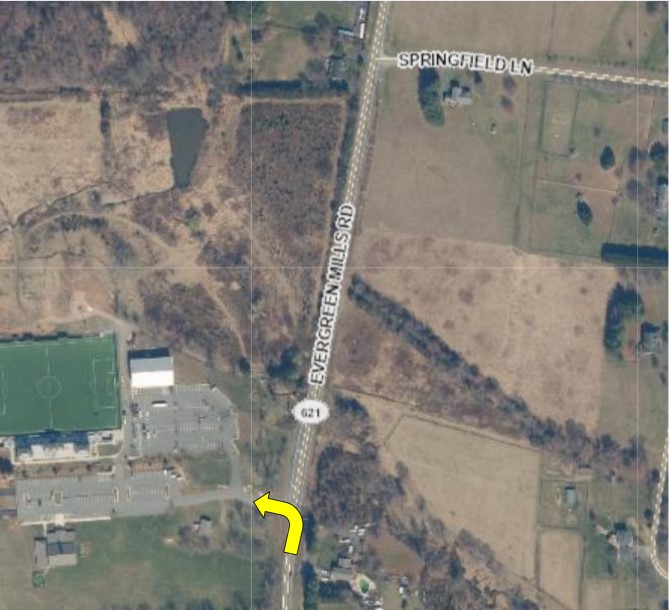
Evergreen Mills Road / Revolution Sportsplex – Westbound Left-Turn Lane |
|
Description: This project provides for the design, land acquisition, utility relocation, and construction of Tier II corridor safety improvements. This includes installation of a new left-turn lane along Evergreen Mills Road (Westbound) at the entrance to the Revolution Sportsplex.
Estimated Timeline by Fiscal Year (FY):
- Design: FY 2025 - FY 2026
- Land Acquisition: FY 2026 - FY 2027
- Construction: FY 2028
- Estimated Completion: FY 2030
Update: The project name was changed from "Safety Improvements – Evergreen Mills Road: Westbound Left-Turn Lane at the Sportsplex" to "Evergreen Mills Road / Revolution Sportsplex – Westbound Left-Turn Lane" during the FY 2024 CIP budget development process.
|
|
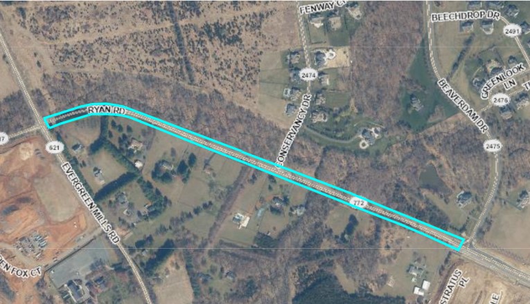
Ryan Road Widening - Evergreen Mills Road to Beaverdam Drive |
|
Description: This project provides for the planning, design, right-of-way acquisition, and widening of Ryan Road, between Evergreen Mills Road and Beaverdam Drive. Ryan Road will be changed from a major collector to a suburban, controlled access, four-lane, median divided roadway with shared use paths on both sides of the road within a 120-foot-wide right-of-way. The scope of this project also includes modifications at the Evergreen Mills Road intersection to accommodate the four-lane roadway.
Estimated Timeline by Fiscal Year (FY):
- Design: FY 2023 - FY 2025
- Land Acquisition: FY 2026 - FY 2027
- Construction: FY 2028
- Estimated Completion: FY 2030
Update: The 30% design plans were submitted to the Loudoun County Department of Building and Development on May 3, 2023, and to VDOT on May 5, 2023.
|
|
Sidewalks, Trails and Shared Use Paths |
|
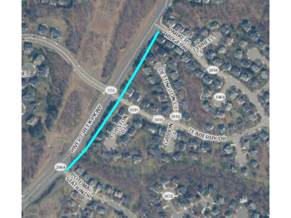
River Creek Parkway Sidewalk |
|
Description: This project develops a missing sidewalk segment along the east side of River Creek Parkway, between Parkers Ridge Drive and Potomac Station Drive.
Estimated Timeline:
- Design: FY 2023
- Land Acquisition: FY 2023 - FY 2024
- Construction: FY 2025 - FY 2026
Update: In this quarter, the design team submitted 100% design plans to B&D, VDOT, and the Town of Leesburg in June 2023. In the next quarter, the design team will review and address any comments received from the 100% plan submission.
Learn more (Quarterly Report/Capital Improvement Projects, 4th Quarter,
|
|
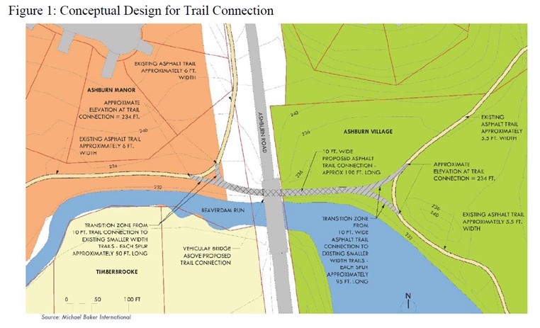
Location: On the north side of Beaverdam Run, underneath the Ashburn Road bridge that goes over Beaverdam Run.
Description: The Board has approved funding to construct a path beneath the Ashburn Road bridge. The path will connect the Ashburn Village trails to the Ashburn Manor trails. On June 21, 2022 The Board voted to allocate $112,000 to complete this project.
Update: DTCI is beginning to work on the preliminary design documents that VDOT will want to see as the development of the waiver/exception requests. The waiver/exception request is for reducing the minimum vertical clearance under the bridge. This process will likely take several months since VDOT’s Central Office in Richmond will need to review the requests. Learn more about the path beneath Ashburn Road.
|
|
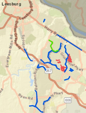
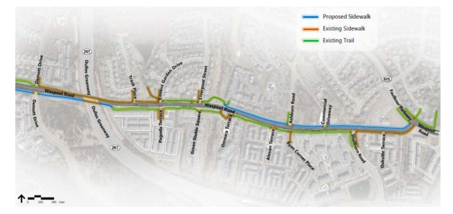
Waxpool Corridor Pedestrian Improvements |
|
Location: Waxpool Road between Faulkner Parkway and Demott Drive.
Purpose: To complete portions of missing sidewalks along Waxpool Road between Faulkner Parkway and Demott Drive. The missing links where the sidewalk is proposed with the corridor-wide pedestrian improvements are shown in blue above. This includes approximately 2,800 linear feet (LF) of sidewalk between Faulkner Parkway and Omeara Terrace on the north side of Waxpool Road, and approximately 1,700 LF of sidewalk between Trask Place and Claiborne Parkway on the south side of Waxpool Road totaling 4,500 LF (0.85 miles). These improvements would provide continuous pedestrian connections along the north and south side of Waxpool Road for the entirety of the corridor study area.
Project Timeline by Fiscal Year (FY):
- Estimated Completion: FY 2027
Update: In this quarter, additional survey and base mapping was completed so utility coordination can be initiated. In the next quarter, the design team will continue utility coordination and request plans and estimates from utility providers so 100% design plans can be submitted. Due to the need for additional survey to conduct utility coordination, completion of the design phase needs to be extended from spring 2023 to winter 2024.
-
Previous Update: In this quarter, the design team developed responses to 100% plan comments and prepared for utility coordination. In the next quarter, the design team will continue to work on the 100% design plan resubmission package and will continue utility coordination.
|
|
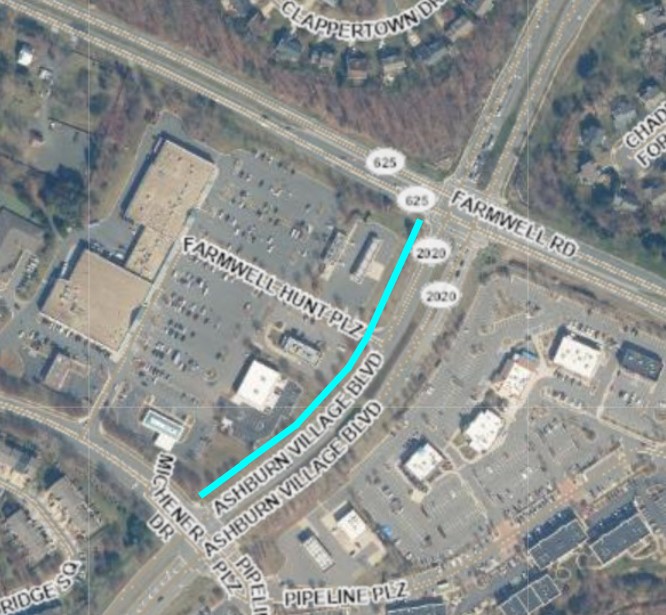
Ashburn Village Boulevard (Farmwell Road to Michener Drive) |
|
Description: Provides for the construction of a 0.16-mile sidewalk along the west side of Ashburn Village Boulevard from Farmwell Road to Michener Drive. This includes the connection to upgraded ADA-compliant pedestrian ramps at Farmwell Road and new/upgraded ramps at Michener Drive.
Estimated Timeline by Fiscal Year (FY):
- Design: FY 2024
- Estimated Completion: FY 2026
Update: During the current quarter, progress continued on the 90% design plans. Coordination with adjacent projects related to land acquisition has also continued. In the next quarter, 90% plan development will be finalized.
-
Previous Update: In this quarter, a design kickoff meeting was held with DTCI staff and VDOT. Field investigations and coordination with other adjacent design projects commenced. In the next quarter, approximately 90% of concept plans will begin being developed.
|
|
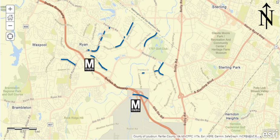
Metro Station Area Pedestrian Improvements |
|
Location: Between the W&OD Trail and the Ashburn and Loudoun Gateway Metrorail Stations.
Description: The purpose of this project is to construct missing segments in the bicycle and pedestrian network within two miles of the Loudoun Gateway and Ashburn Metrorail stations. This includes pedestrian signal upgrades and connecting existing shared-use paths to new Americans with Disabilities Act (ADA) ramps, at the following intersections:
- Ashburn Village Boulevard and Shellhorn Road
- Farmwell Road and Ashburn Village Boulevard
- Farmwell Road and Smith Switch Road
The remaining projects have been organized into the following three separate project groups:
Project 1:
Route 606 - A shared-use path on the west side of Route 606 from the existing shared-use path from the Dulles Greenway to Moran Road and extending along the west side of Moran/Lockridge Road to the Loudoun Gateway Metrorail Station.
Estimated Project Timeline:
- Construction phase to begin in early 2024.
- Completion anticipated for summer, 2025.
Update: In this quarter, the pre-advertisement conference (PAC) meeting was held on June 14, 2023. Coordination with utility companies continued. In the next quarter, the right of way plans and construction advertisements plans will be complete.
__________________________________
Project 2:
Wynridge Drive/Claude Moore Avenue - A shared-use path on the south side of Wynridge Drive/Claude Moore Avenue to connect the existing trail at Millwick Terrace to Old Ryan Road.
Ashburn Village Boulevard (North) - Missing segments of shared-use paths on the east side of Ashburn Village Boulevard between Waxpool Road and Shellhorn Road.
Waxpool Road - A shared-use path on the west side of Waxpool Road between Red Rum Drive and Farmwell Road.
Smith Switch Road - A shared-use path on the west side of Smith Switch Road between Stoney Run Place and Ice Rink Plaza.
Estimated Project Timeline:
- Construction starts in early 2025.
- Completion: TBD*.
Update: Right of Way acquisitions will begin in the late fall of 2023, expected to last about a year. Utility relocations are expected to last for 15 months.
__________________________________
Project 3:
Shellhorn Road - A sidewalk or shared-use path on the south side of Shellhorn Road beginning at Greenway Corporate Drive and connecting to the existing trail west of Devin Shafron Drive.
Ashburn Village Boulevard (South) - Missing segments of shared-use paths on the east side of Ashburn Village Boulevard between Red Rum Drive and Farmwell Road.
Prentice Drive - A shared-use path on the north side of Prentice Drive to provide a continuous path between Lockridge Road and Pacific Boulevard.
Pacific Boulevard - A shared-use path on the west side of Pacific Boulevard to provide a continuous path between Dresden Street and Waxpool Road.
__________________________________
Estimated Project Timeline:
- Construction starts in late 2025.
-
Completion: TBD*.
Update: Right of Way acquisitions to begin in the late Fall of 2023, expected to last about a year. Utility relocations expected to take approximately 2 years.
Learn more (Quarterly Report/Capital Improvement Projects, 4th Quarter, FY 2023, Page 83 of the PDF. The project name is “Metro Station Area Pedestrian Improvements”).
*Packages 2 and 3 are expected to utilize a task order construction contract to accelerate the construction phase. Once a task order contract is secured, an estimated completion date can be determined.
|
|
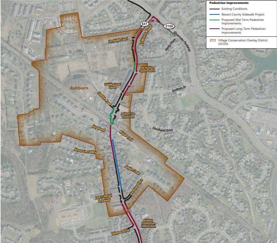
Traffic Study of Ashburn Road from Gloucester Parkway to Ashburn Farm Parkway/Farmwell Road |
|
In January 2019, The Board directed staff to assess the cost and identify funding for a traffic study along Ashburn Road (Route 641) between Gloucester Parkway to Ashburn Farm Parkway/Farmwell Road. In October 2020, staff presented the findings of that study and made the following recommendations:
Short-Term Recommendations:
-
Install two Gateway signs on Ashburn Road and (proposed) one sign along Hay Road (Completed).
-
Install on-street shared lanes (sharrows) for bicyclists along Ashburn Road between Stubble Road and Haven Crest Way (Completed).
-
Install two Pole Mounted Speed Display Signs (PMSDs) along Ashburn Road (Completed).
-
Install “Additional $200 Fine” signs throughout the posted 25 mph speed limit section of Ashburn Road (Completed).
-
Install stamped asphalt, a decorative pattern, that is imprinted or painted onto asphalt pavement, such as a brick pattern (Completed).
-
Tree trimming is proposed at select locations along the corridor where sight distance is limited due to dense, overgrown foliage (Completed).
Mid-term recommendations:
Recommended mid-term improvements will address the missing link segments along the subject corridor where the impact to utilities and public right-of-way is minimal. These improvements include installation of segments of sidewalks, curb and gutter and storm drainage system on both sides of Ashburn Road, north of the W&OD Trail. The missing pedestrian links between the W&OD trail and Gloucester Parkway are included in the Prioritized Project List for Loudoun’s Sidewalk and Trail Program. Updates to those missing links can be found below can be found on the item below.
Long-Term Recommendation:
Recommended long-term improvements will address the missing link segments along the subject corridor where impacts to utilities and public right-of-way are substantial. These improvements include installation of sidewalks and a shared-use trail, including curb, gutter and storm drainage system, which will comply with the ultimate condition as described in the CTP. A shared-use trail is proposed on the eastern side of Ashburn Road between Stubble Corner Square and Gloucester Parkway. Sidewalks are proposed on both sides of Ashburn Road from Grantner Place to the Beaverdam Run Bridge, and from Parkhurst Place/Thatcher Terrace to Ashburn Farm Parkway/Farmwell Road. The Board also directed staff to prepare a scope of work and cost estimates associated with improvements to the Beaverdam Run Bridge. This analysis came back to the Board at the June 21, 2022, BOS Business Meeting with 3 pedestrian bridge design concepts for Board Consideration. The Board endorsed the third design concept. This improvement has been listed as a “Project Identified for Future Development” in the FY 2024 CIP and is waiting to receive funding during future FY budget deliberations. Learn more about the Beaverdam Run Pedestrian Bridge here.
Learn more (Response to Board Member Initiative: Traffic Study of Ashburn Road from Gloucester Parkway to Ashburn Farm Parkway/Farmwell Road | from the October 06, 2020, BOS Business Meeting).
|
|
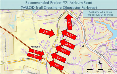
Sidewalk study: Ashburn Road from the W&OD Trail to Gloucester Parkway
|
|
Description: In 2020, DTCI presented the Board of Supervisors with the results of the Prioritization Study for the Capital Improvement Program (CIP) Sidewalk and Trail Program. The study identified the 12 highest ranked missing segments and recommended that the Board of Supervisors forward 12 projects to the Fiscal Year (FY) 2022 CIP budget deliberation. This study identified the segment of Ashburn Road, between the W&OD Trail and Gloucester Parkway as priority number 7.
The Adopted improvements provide for the construction of 0.53 miles of sidewalks and shared-use paths along the Ashburn Road Corridor. 0.12 miles will be constructed between the W&OD Trail Crossing and Gloucester Parkway on the west side of Ashburn Road. On the east side of Ashburn Road, 0.38 miles of shared-use path and sidewalk will be constructed. Finally, 0.03 miles of shared-use path will be constructed between Ashburn Road to West of Amity Place.
Estimated Timeline by Fiscal Year (FY):
- Design: FY 2025
- Estimated Completion: FY 2029
Update: This project is estimated to begin in Fiscal Year 2024 and be completed by Fiscal Year 2029. Design funding for Ashburn Road (within Ashburn Village to Gloucester Parkway) will become available in FY 2025.
|
|
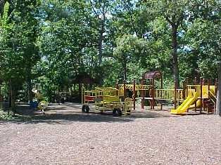
Ashburn Park: Is a 16-acre park that features a creek, natural trails, a rentable pavilion, a picnic area, a playground, a restroom, and a wooded area.
Recommendation: The Capital Asset Preservation Program (CAPP) designated that the rentable pavilion needs repair.
Update: The Department of Parks and Recreation has determined that a full redesign of the park is necessary to accommodate a new pavilion. The roof on the existing pavilion has been replaced for longevity.
-
Previous Update: The existing pavilion is planned to be replaced with a new structure late 2022 early 2023. Design on the pavilion is currently in review.
|
|
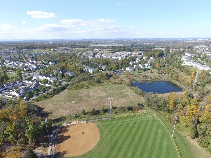
Trailside Park: Is a 20-acre park is home to Madison Small Softball Complex and is adjacent to the W&OD Trail.
Recommendation: The Capital Asset Preservation Program (CAPP) designates that a park bridge will be repaired, and two park bridges will be replaced, with help from the Department of General Services. These improvements will include a channel restoration, a floodplain study, and inclusion of a retaining wall and guardrails.
Update: Trailside Park Fields 1,2,3 renovation started; Trailside Park dugout covers were ordered. In the next quarter, Trailside Park dugout cover installation is expected to be completed. Bridge repairs and replacements are still planned.
-
Previous Update: In Summer 2022, a full renovation of Trailside Park baseball/softball fields 1, 2, and 3 began. Pricing for an athletic field lighting replacement is being finalized.
|
|
Countywide Linear Parks and Trails (LPAT) System |
|
Purpose: To connect and protect the natural, recreational, and cultural resources of Loudoun County. Most segments border linear features, such as streams, ridges, or abandoned roadways. The segments could be wildlife habitats or scenic resources and be for private or public use. Public use trails accommodate horse-back riding, hiking, biking, and connect to the paved pedestrian and bicycle transportation network. The trails may also connect to natural and community resources, enabling people to travel to schools, community centers, and parks without motorized vehicles.
Project Timeline by Fiscal Year (FY):
- Land acquisition: FY 2027 - 2028
- Construction: FY 2028
Update: Edgar Tillett - Trail building complete. The trail realignment is 100% complete. The old trail will be shut down by the end of June 2023. Goose Creek Pointe - Staff has completed the preliminary trail alignments and will be creating GIS maps. There is no projected completion date for this project.
-
Previous Update: The Trail Maintenance Coordinator and Trail Program Coordinator positions are being run through HR to begin onboarding. These new positions started in December 2022. Staff is working with the Communication and Marketing teams to create a scope of work to put out to bid. The next Linear Parks and Trails Committee Meeting will take place February 9, 2023.
Learn more (Business Meeting Action Item - Item 04 Creation of a Countywide Linear Parks and Trails System)
|
|
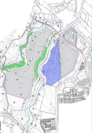
Description: This project provides funding for the design, acquisition, and construction of the signature project described in the LPAT Implementation Plan. Improvements include the construction of pedestrian bridges in the Goose Creek and Broad Run Stream Valleys, restoration of the historic Toll House, parking/access points, trails, benches/seating areas, and trailhead restroom facilities. The project will also provide for a canoe/kayak launch in the Goose Creek Stream Valley and wayfinding signage for connectivity to major regional trail networks. Funding is also included to construct a pedestrian bridge over Horsepen Run to complete connectivity to the Potomac Heritage Trail in or proximate to Algonkian Regional Park
Project Timeline by Fiscal Year (FY):
- Design: FY 2024 - 2025
- Construction: FY 2025 - 2026
- Completion: FY 2026
Update: This project replaced the Broad Run Stream Valley Park and Goose Creek Stream Valley Linear Park projects.
-
Previous Update: In FY 2022, funding was advanced to renovate the historic Broad Run Toll House to create a new trailhead access and parking area, opening trail access to the public. The renovated Broad Run Toll House portion of the project will reach completion before the entire project is complete. The renovation of the Broad Run Toll House was added to this project during the FY 2022 CIP development process in response to a request from the Department of Parks, Recreation, and Community Services (PRCS) and is consistent with the Board of Supervisors’ priority of preserving historic sites in Loudoun County.
|
|
Approved Land Applications and Developments
(Progressing Toward/In the Building Phase)
|
|
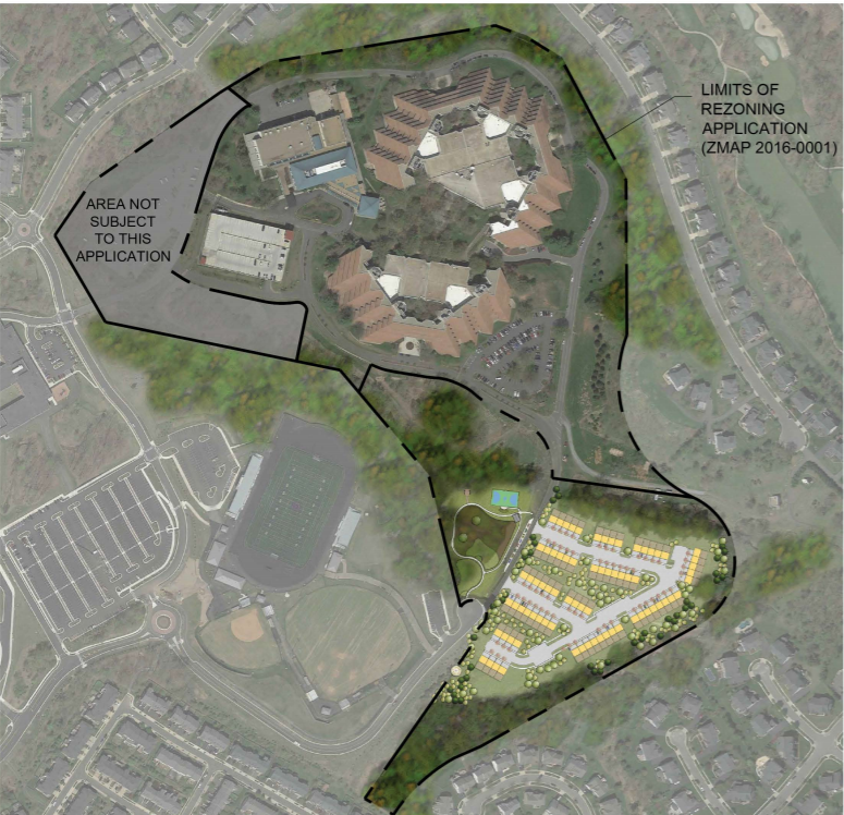
National Conference Center East |
|
Location: 18920 Upper Belmont Place.
Approved: March 22, 2018
Description: The approved proposal calls for building up to 74 single family attached dwelling units. These are age restricted homes and at least one resident must be 55 years or older and no one under 18 years old may live here. This includes the construction of an eight-foot-wide trail that meanders through the open space and could potentially connect to other trails in the area. The trail will be granted a public access easement to the county for public use.
|
|
Ashburn Chase
&
Regency at Belmont Chase Townhomes
|
|
Location: Bordering Claiborne Parkway, Russell Branch Parkway and Ashburn Road.
Approved: March 6, 2018
Description: 1) To construct two multi-family buildings each with 48 dwelling units (Complete). 2) To construct a townhome community with 105 single-family attached age restricted (+55) dwelling units (Active Adult Units) and the necessary roads and utilities. This includes the construction of a sidewalk along the property frontage of Russell Branch Parkway and Ashburn Road, a bus stop shelter on Russell Branch and a public access easement to an eight-foot-wide multi-purpose permeable surface trail (the "Connector Trail") granted to the County between Ashburn Road and Claiborne Parkway, with a minimum of five fitness/workout stations.
|
|
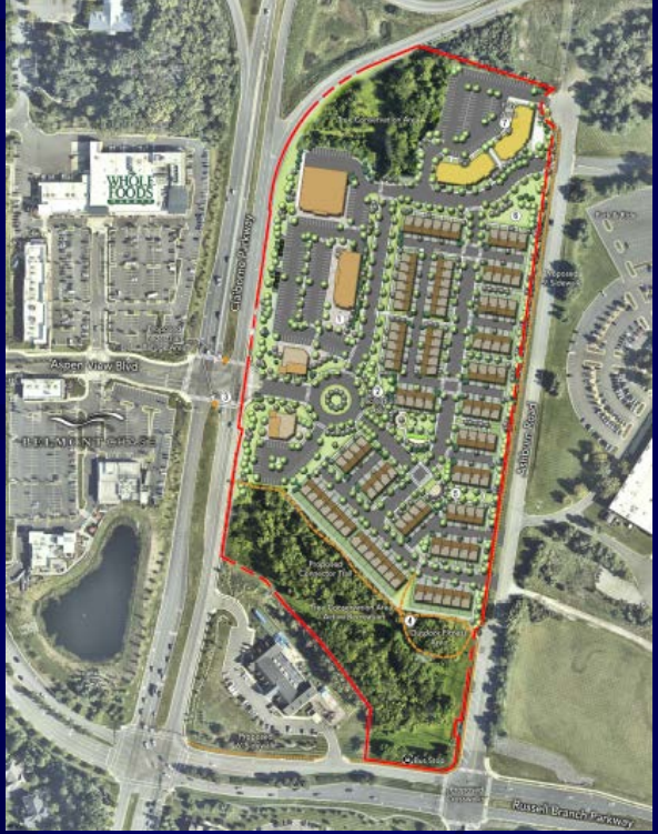
Location: In the southeast corner at the intersection of Sycolin Road and the Dulles Greenway.
Approved: December 12, 2019
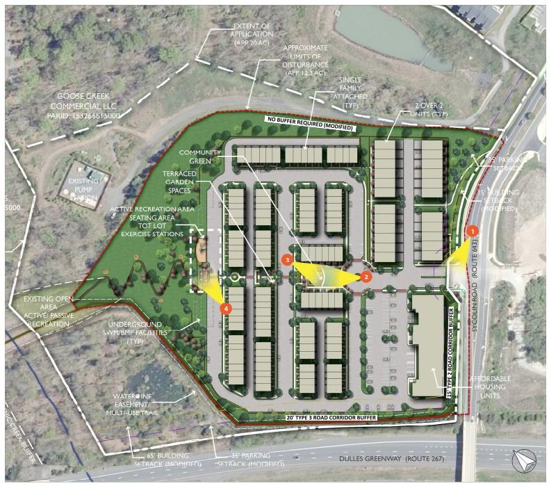
Description: To build 232 multi-family stacked units and 50 studio and 1-bedroom multi-family units. This includes the construction of a sidewalk along the property frontage of Sycolin Road and an outdoor landscaped park area along the Dulles Greenway (Route 267) frontage of the property, which will incorporate the existing six-foot wide multi-purpose trail and landscaping. This "Linear Park" will be located within a public access easement granted to the County at no public cost.
|
|
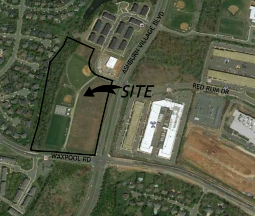
Location: In the northwest corner at the intersection of Waxpool Road and Ashburn Village Boulevard.
Approved: January 19, 2021
Description: To build up to 384 units, 200 of which will be stacked multi-family units (2 over 2) and the remaining 184 dwelling units will be multi-family units. This includes construction of a bus shelter along Ashburn Village Boulevard, a roundabout at Waxpool Road and Faulkner Parkway, and a ten-foot-wide shared use path with associated lamp post trail lights and street trees along Waxpool Road and Ashburn Village Boulevard.
|
|
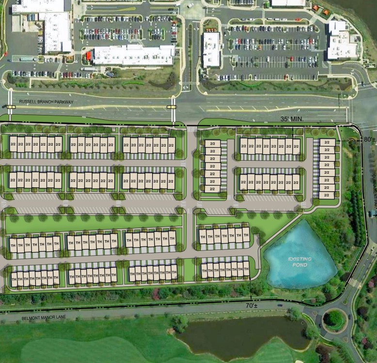
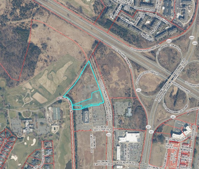
Location: The site is located near the northwest corner at the intersection of Tournament Parkway and Russell Branch Parkway
Approved: November 16th, 2021
Description: The approved proposal calls for the construction of 60 single family attached dwelling units and 142 multifamily stacked dwelling units, for a total of 202 dwelling units. In addition to the construction of 202 dwelling units, the applicant has agreed to construct a bus shelter along Russell Branch Parkway, provide a bike share easement, build a 10-foot wide asphalt shared use path along Russell Branch Parkway, install a fishing dock, maintaining a Landscape Buffer along Belmont Manor Lane and agreed to conduct a noise impact study and build two crosswalks (if warranted by VDOT), after the construction of the Russell Branch Parkway is completed.
|
|
Location: This site is located on Russell Branch Parkway, immediately passed Saint David's Episcopal Church.
Approved: 1/17/2023
Description: “Belmont Park” is proposed application to rezone 12.16 acres directly north of Saint David’s Episcopal Church and School to allow the construction of a residential development. The development includes one-hundred and sixty-three townhouses/multi-family units. These include fifty-seven seventy-one) single-family attached units and one-hundred and six (revised from seventy) two-over-two units. The residents are currently zoned to Newton-Lee Elementary School, Belmont Ridge Middle School, and Riverside High School.
|
|
Belmont Automobile Service Station |
|
Location: This site is located at the southwest corner of Belmont Ridge Road and Portsmouth Road.
Approved: 1/17/2023
Description: “Belmont Automobile Service Station” is a proposed Special Exception to allow the construction of a service station in Belmont Greene Village Center over 2.13 acres of land.
|
|
Legislative Land Use Applications
in the Ashburn District
|
|
Changes to the Code of Virginia [§ 15.2-1427(F) and 15.2-2204(A)] requires that board approval of any land use application or adoption of any ordinance amendment occur no more than 14 days after a descriptive public notice has been published.
Modifications to the Rules of Order apply to the structure of BOS Public Hearing Agendas. All items appearing on the agenda of a BOS Public Hearing will be placed into one of the following sections: “Hearing of New Items,” “Hearing of Returning Items Ready for Action,” and “Adoption of the Consolidated Agenda.”
-
Hearing of New Items: Unless the Board sends an item from this section to a standing committee, or votes to suspend its rules, the default “next step” for these items is to be forwarded to a future BOS Public Hearing for action.
-
Hearing of Returning Items Ready for Action: Items that have appeared on the agenda of a previous BOS Public Hearing will be placed in the section of the agenda titled “Hearing of Returning Items Ready for Action.”
-
Approval of Consolidated Agenda: At the beginning of the consolidated public hearing, the Chair will announce the individual items proposed for the consolidated agenda. After a call for public speakers has been made, the BOS may act on each item, without voting to suspend its rules. If there are speakers for an item on the consolidated agenda, the item will be removed from the consolidated agenda and placed on the standard public hearing agenda. To qualify for placement on the consolidated agenda, an item must have unanimous support from the BOS, as well as a recommendation of approval from county staff and the planning commission. “New” or “returning” items may be added to the consolidated agenda if the above criteria are met.
|
|
Northstar Square
Application Number: LEGI-2023-0020
(Formerly known as "Mercer Crossing")
|
|
Description: "Northstar Square” is a proposed application to rezone 110.86 acres to allow the construction of 1,138 dwelling units. These include 297 single-family attached units, 485 multi-family stacked units, and 356 multi-family attached units. The residents are currently zoned to Newton-Lee Elementary School, Belmont Ridge Middle School, and Riverside High School.
Update: The Northstar Square rezoning application was removed from the September 13th BOS Public Hearing agenda by the developer. The developer has indefinitely deferred their application.
-
Previous Update: At the June 8th Planning Commission Work Session, the Planning Commission voted to send the Northstar Square application to the September 13th, Board of Supervisor's Public Hearing, with a recommendation of approval.
-
Previous Update After the Planning Commission voted to send the Northstar Square application to the Board of Supervisors, with a recommendation of denial, the applicant requested that the recommendation be reconsidered, the recommendation was rescinded, and was sent back to the Planning Commission’s Work Session on June 8th.
-
Previous Update: At the April 13th, Planning Commission Work Session, the Planning Commission voted to send this application to the June 14th Board of Supervisors Public Hearing.
-
Previous Update: At the February 9th, 2023, Planning Commission Work Session, the Planning Commission voted to send this application to future work session on April 13th.
-
Previous Update: This application is scheduled to come to the February 9th, 2023 Planning Commission Work Session.
-
Previous Update: County staff from multiple departments are reviewing this application with the applicant.
For more information on this application, click here. To review the application documents, scroll down to the middle of the page and click the “Attachments” tab. To leave a comment click here.
|
|
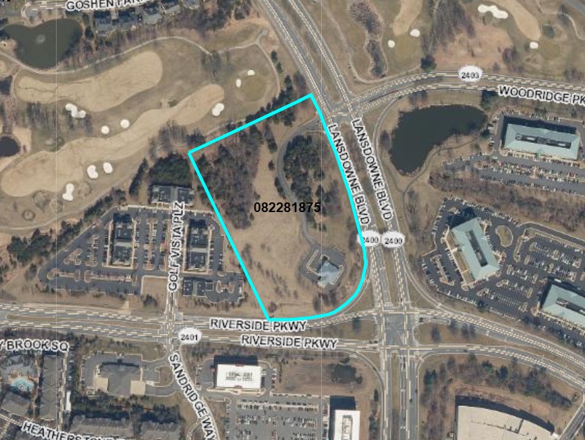
Lansdowne Blvd Rezoning
Application Number: LEGI-2023-0026
(Also known as "Elm Street Development")
|
|
Description: “Lansdowne Blvd Rezoning” is a proposed application to rezone 9.22 acres to allow the construction of an additional 120 dwelling units. These include 72 single-family attached units and 48 multi-family stacked units. The residents are currently zoned to Steuart W. Weller Elementary School, Belmont Ridge Middle School, and Riverside High School.
Update: At the September 14th, Planning Commission Work Session, the Planning Commission voted to send this application to the November 15th Board of Supervisors Public Hearing.
-
Previous Update: At the May 23rd, 2023, Planning Commission Work Session, the Planning Commission voted to send this application to future work session. The date of this work session is September 14th, 2023.
-
Previous Update: This application is scheduled to come to the May 23rd, Planning Commission Public Hearing.
For more information on this application, click here. To review the application documents, scroll down to the middle of the page and click the “Attachments” tab. To leave a comment click here.
|
|
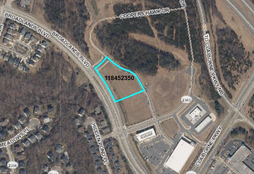
Broadlands Section 104
Application Number: LEGI-2023-0024
|
|
Description: “Broadlands Section 104” is a proposed application to rezone 10.19 acres to allow the construction of 106 dwelling units. These include 45 single-family attached units, 30 multi-family stacked units, and 31 multi-family attached units. The residents are currently zoned to Cedar Lane Elementary School, Trailside Middle School, and Stone Bridge High School.
Update: At the September 14th, Planning Commission Public Hearing, the Planning Commission voted to send this application to the November 15th Board of Supervisors Public Hearing.
-
Previous Update: At the June 27th, 2023, Planning Commission Public Hearing, the Planning Commission voted to send this application to a future work session. The date of this work session is September 14th, 2023.
-
Previous Update: This application is scheduled to come to the June 27th, Planning Commission Public Hearing.
-
Previous Update: County staff from multiple departments are reviewing this application with the applicant.
For more information on this application, click here. To review the application documents, scroll down to the middle of the page and click the “Attachments” tab. To leave a comment click here.
|
|
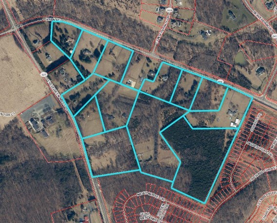
Arcola Farms Residential
Application Number: LEGI-2023-0034
|
|
Description: “Arcola Farms Residential” is a proposed application in Ashburn and Little River Districts to rezone 80.8 acres to allow the construction of three hundred and seven (307) single-family detached residential units. The residents are currently zoned to Sycolin Creek Elementary School, Brambleton Middle School, and Independence High School.
Update: County staff from multiple departments are reviewing this application with the applicant.
For more information on this application, click here. To review the application documents, scroll down to the middle of the page and click the “Attachments” tab. To leave a comment click here.
|
|
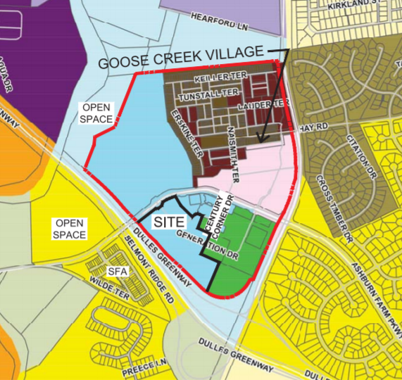
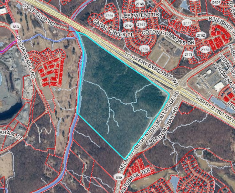
Goose Creek Village West
Application Number: LEGI-2023-0038
|
|
Description: “Goose Creek Village West” is a proposed application to rezone 20 acres (revised from 25 acres) to allow for the construction of an additional 222 residential units. These include 104 single-family attached units, 46 multi-family stacked units, and 72 multi-family attached units. The residents are currently zoned to Belmont Station Elementary School, Trailside Middle School, and Stone Bridge High School.
Update: County staff from multiple departments are reviewing this application with the applicant.
For more information on this application, click here. To review the application documents, scroll down to the middle of the page and click the “Attachments” tab. To leave a comment click here.
|
|
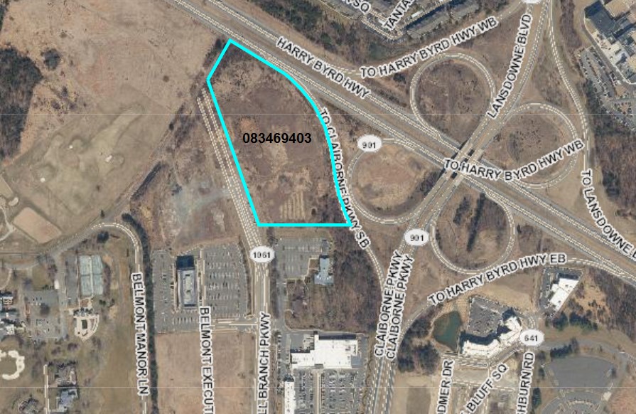
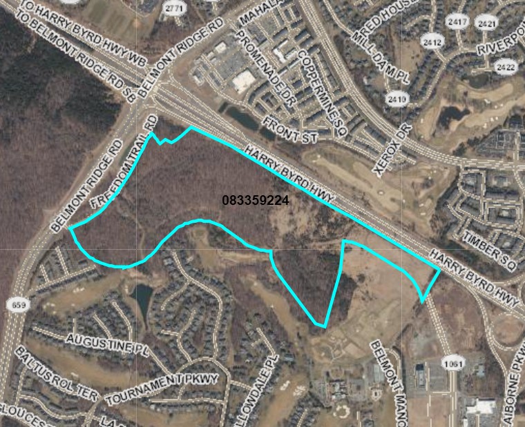
Belmont Innovation Campus
Application Number: LEGI-2023-0048
|
|
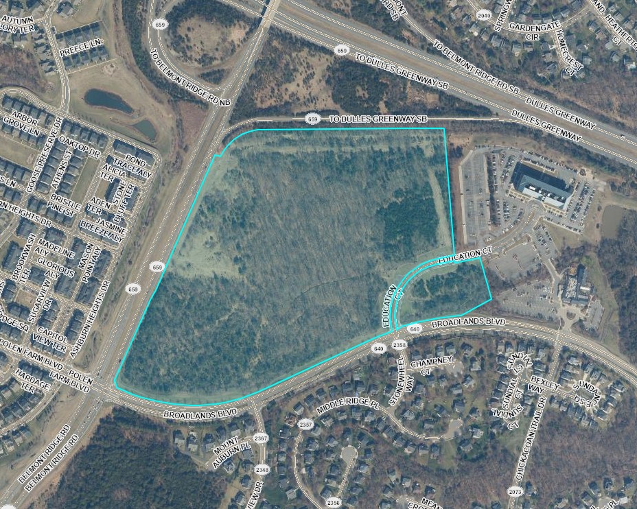
Description: “Belmont Innovation Campus” is an application to rezone 84.52 acres to allow for the construction of a data center.
Update: The application for the Belmont Innovation Campus (LEGI-2023-0048) is scheduled to come to the September 26th, Planning Commission Public Hearing.
-
Previous Update: County staff from multiple departments are reviewing this application with the applicant.
For more information on this application, click here. To review the application documents, scroll down to the middle of the page and click the “Attachments” tab. To leave a comment click here.
|
|
Luck Stone Leesburg Plant
Application Number LEGI-2023-0084
|
|
Description: Luck Stone Leesburg Plant is a Zoning Concept Plan Amendment (ZCPA) Application to amend proffers and development conditions to allow for expansion of mining operation in quarry B, on the east side of Goose Creek, underneath the current processing plant, resulting in the processing plant and point of sale to move to the west side of the property. On the west side of Goose Creek, the application is amending the development conditions to allow for Stonewater Lane to be used for shipping mined materials off-site and to rezone a portion of Luck Stone’s property to allow for data center uses. According to Luck Stone, if this application is approved, the timing of the relocation of the point of sale to Stonewater Lane and the expansion of mining operations in quarry B is subject to several variables but is not currently anticipated for approximately 25 years.
Update: County staff from multiple departments are reviewing this application with the applicant.
For more information on this application, click here. To review the application documents, scroll down to the middle of the page and click the “Attachments” tab. To leave a comment click here.
|
|
Goose Creek Retail LLC
Application Number: LEGI-2023-0067
|
|
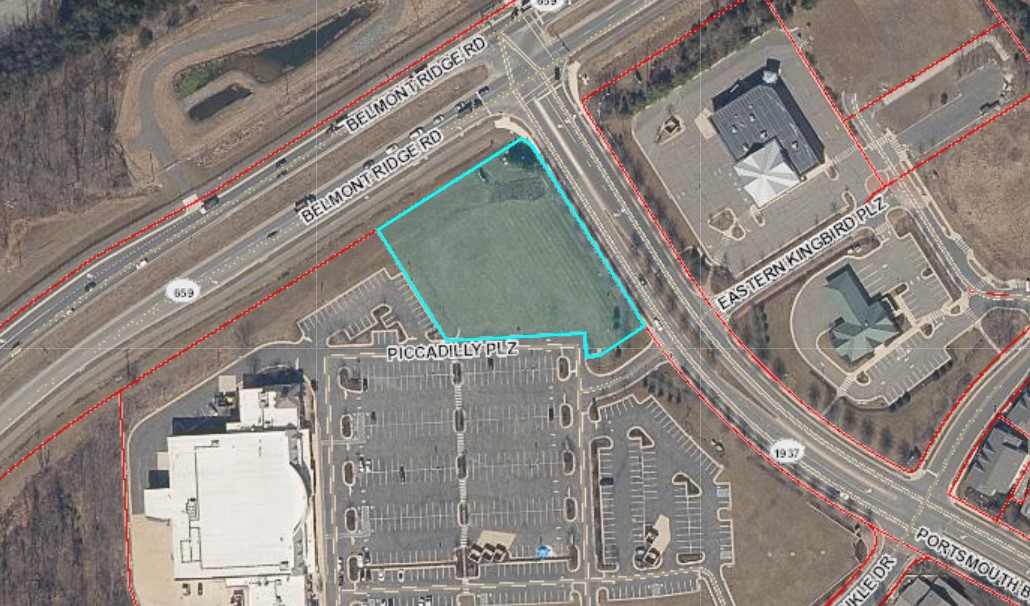
Description: “Goose Creek Retail LLC” is a Special Exception application to permit a restaurant with a drive-thru use on approximately 0.51 acres of the property.
Update: This application is scheduled to come to the October 24th Planning Commission Public Hearing.
-
Previous Update: County staff from multiple departments are reviewing this application with the applicant.
For more information on this application, click here. To review the application documents, scroll down to the middle of the page and click the “Attachments” tab. To leave a comment click here.
|
|
Belmont Cove
Application Number: LEGI-2023-0074
|
|
Description: “Belmont Cove” is a Zoning Map Amendment application to rezone 8 acres to allow for the construction of 80 multifamily residential units. The residents are currently zoned to Newton-Lee Elementary School, Belmont Ridge Middle School, and Riverside High School.
Update: County staff from multiple departments are reviewing this application with the applicant.
For more information on this application, click here. To review the application documents, scroll down to the middle of the page and click the “Attachments” tab. To leave a comment click here.
|
|
Significant By-Right Developments in the Ashburn District |
|
By-right: A "by-right" development is an application that does not require approval from the Board of Supervisors. The approval/denial of applications for by-right developments are managed administratively by county staff and must conform to the current zoning ordinance.
|
|
Description: “Vantage VA 3” is a by-right application which plans to build four data center buildings on 89 acres. The underlying zoning is Planned-Development Office Park (PDOP) and Planned-Development Industrial Park (PD-IP). Data Centers are allowed by-right on PD-OP and PD-IP zoned land.
For more information on this application, click here. To review the application documents, scroll down to the middle of the page and click the “Attachments” tab.
|
|
Description: “CyrusOne Broadlands Data Center” is a by-right application which plans to build a 41,000sf data center on 58 acres. The underlying zoning in Planned-Development Industrial Park (PD-OP). Data Centers are allowed by-right on PD-OP zoned land.
For more information on this application, click here. To review the application documents, scroll down to the middle of the page and click the “Attachments” tab.
|
|
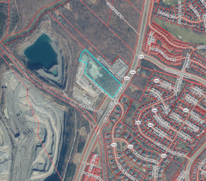
Description: “Baker-Beam DC Yard-Luck Property” is a Site Plan application (STPL-2022-0021) to build a two story “shop” building for contractor services, a three story office building, underground utility infrastructure that is associated with the two buildings and a parking lot. This parcel is 11.1 acres and is zoned MRHI (Mineral Resources/Heavy Industry).
For more information on this application, click here. To review the application documents, scroll down to the middle of the page and click the “Attachments” tab.
|
|
21819 Ashburn Road Property
Application Number: BLDR-2023-001655
|
|
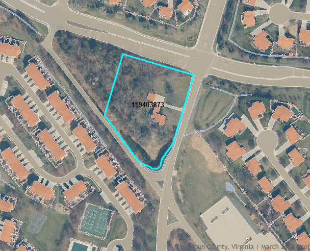
Description: "21819 Ashburn Road" is a building residential demolition application (BLDR-2023-001655) which plans to demolish the single family home on the property. The house at this address was built in the 1920's and has been vacant for some time. The owner wishes to demolish the home as quickly as possible due to safety concerns.
For more information on this application, click here. To review the application documents, scroll down to the middle of the page and click the “Attachments” tab.
|
|
Was this Newsletter forwarded to you? |
|
As your representative on the Loudoun County Board of Supervisors, my top priority has been to serve your needs and work towards the betterment of our community. Please don’t hesitate to contact me directly or my staff with any input and ideas you may have for the Ashburn District. The best way to reach me is by email, which I monitor on a regular basis. |
|
Mike Turner
-
Supervisor
703-777-0205
|
|
Rachael Mai
-
Chief of Staff
703-737-8180
|
|
Joel Gicker
-
Legislative Aide
571-440-1947
|
|
|
|
|
|
|