Early Green‑Up Meets March Madness: Storms, Wind, and a Sudden Cold Snap Ahead

Updated 3-15-26 at 3:30 PM Eastern

Good afternoon, folks! Whether it’s basketball or the weather, March Madness is in full swing. The immediate focus this evening and tonight is on a strong line of storms expected to move through the region. After that, attention quickly shifts to a significant cold spell during the first half of the workweek. This comes on the heels of an exceptionally warm start to March that has vegetation greening up and developing rapidly across the state. Ahead of Selection Sunday, here’s a quick summary to help stay weather‑aware in the days ahead.

Tipping off this update is a look at a strong cold front set to push through the region later this evening and overnight. Ahead of any storms, a Wind Advisory is currently in effect for much of Kentucky. It's been a very breezy day, with sustained southerly winds of 20 to 30 mph and gusts frequently over 40 mph. A High Wind Warning has also been issued for portions of Western Kentucky, where gusts could reach 60 mph. As of 3:00 PM EDT, the Kentucky Mesonet station in Union County owns the highest gust thus far of 52 mph.


The cold front will trigger a line of strong to severe thunderstorms, entering western Kentucky around 7:00 PM EDT/6:00 PM CDT and progressing eastward through the overnight hours (timing courtesy of NWS Louisville, below). According to the latest Storm Prediction Center outlook issued at 12:30 PM EDT, the greatest risk for severe weather extends across Western and Central Kentucky, where an Enhanced Risk is in place (level 3 out of 5).


Given the strong wind energy associated with this system, damaging straight-line winds are the primary concern. However, tornadoes cannot be ruled out, particularly just ahead or embedded within the line of storms. While the overall tornado risk remains secondary, an isolated strong tornado (EF-2) is possible. Again, the main threat will be damaging winds, with localized gusts potentially up to 75 mph.

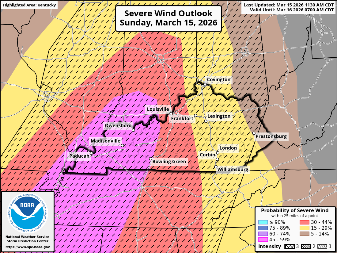
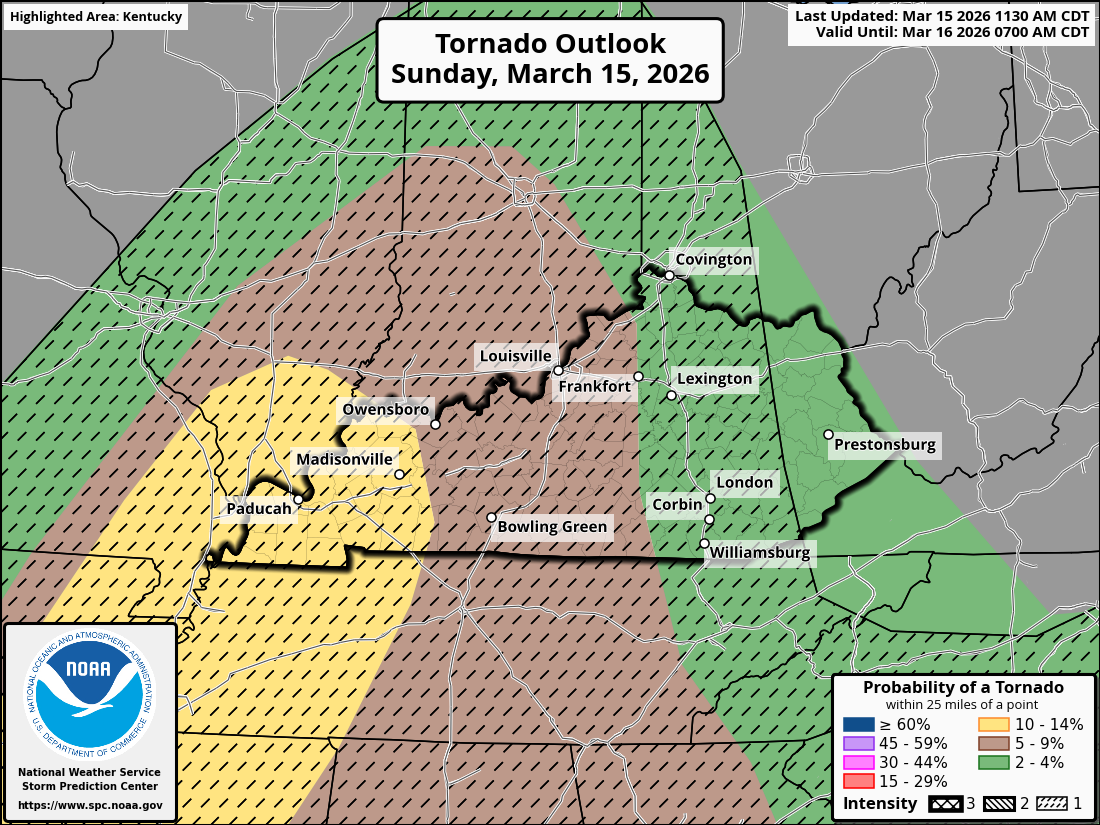
One additional item worth highlighting with today’s outlook is the new intensity-based symbology that the Storm Prediction Center (SPC) introduced on March 3rd. You may notice dashed areas overlaid on the shaded color regions in the maps below, included on both the Severe Wind and Tornado outlooks.


The shaded color regions show where severe weather is expected and how widespread it may be. The dashed areas, however, represent potential storm intensity. For today’s event, the dashed areas indicate a lower‑end significant severe weather potential.


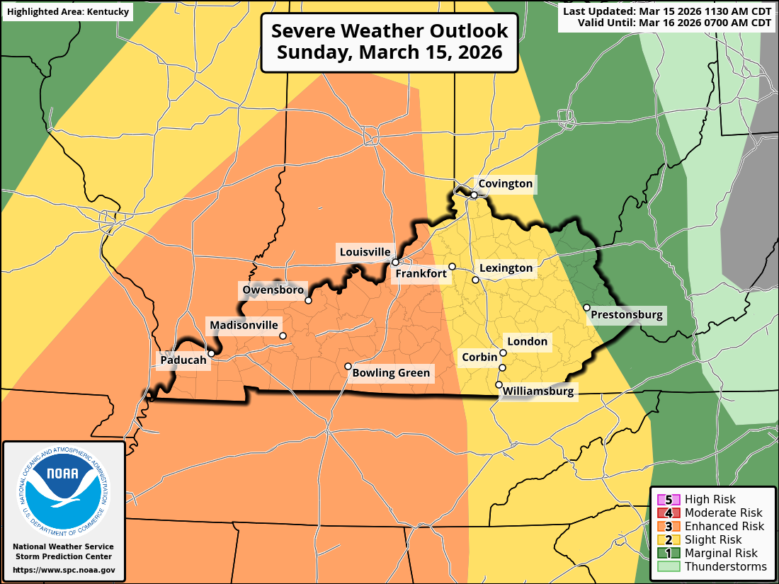
Interpreting today’s outlook, the Enhanced Risk indicates that numerous severe storms are possible with this system. A storm is classified as severe if it produces—or is capable of producing—winds of 58 mph or greater, hail at least 1 inch in diameter, or a tornado.

Within the dashed areas, there is a localized risk of significant severe weather, including peak wind gusts near 75 mph and/or a tornado reaching EF‑2 intensity. While the overall chances for these particular events are not high (isolated in nature), the potential is there and bears monitoring. The SPC has produced a short, informative video explaining these outlook changes, here.


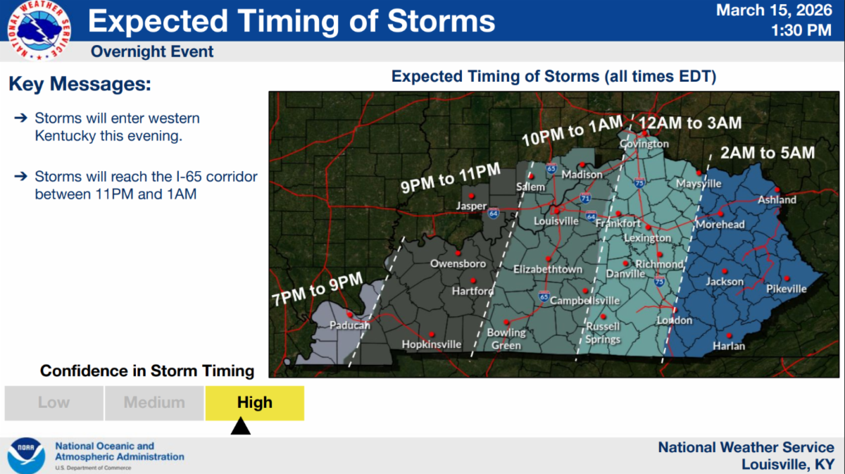
As always, for the most accurate and up‑to‑date information, including timing and local impacts, I’ve included forecast briefings from each National Weather Service office across Kentucky below. Please be sure to have multiple ways to receive warnings, especially since this will be an overnight event for many areas. While storms should move through relatively quickly, it’s important to stay weather‑aware and prioritize safety.


Western KY - NWS Paducah, KY


Central KY - NWS Louisville, KY


Eastern KY - NWS Jackson, KY

Cold spell on the way


Following the line of storms, temperatures are set to take an abrupt turn downward, which is less‑than‑ideal given how warm it's been recently. Earlier starts to the growing season have become a notable trend over the past decade, largely tied to generally warmer winters. While the 2025–26 winter ended up cooler overall, February temperatures averaged close to normal, and the start of March has been exceptionally warm.


Just how warm? Through March 14, the average statewide temperature is running more than 12°F above normal, and vegetation across Kentucky is responding accordingly. Reports from our Fruit Extension Team indicate that some peaches have already reached full bloom, while small grains specialists are noting wheat advancing into Feekes 6 (jointing) across Western KY.


To put this into context, I’ve included a few graphs below showing growing degree day (GDD) accumulations (base 50°F) for each year over the past decade at Lexington, Bowling Green, and Paducah. In all three locations, the current year (marked by the star) shows development ahead of schedule compared to many years in the past decade. In fact, Bowling Green is trailing only 2023 as of March 14. Bottom line: if it feels like vegetation is running ahead of schedule this year, you’re not imagining it.

Expect high temperatures only in the 30s on Monday and Tuesday, with breezy conditions on Monday adding to the chill. Wind chills could dip into the single digits Tuesday morning. Yes, we may even see some snow with this system, but ground temperatures remain far too warm for any meaningful impacts.


Overnight lows will be coldest Tuesday morning, falling into the mid‑teens to low 20s across much of the state. Many locations will again drop into the 20s Wednesday morning, with teens possible in eastern Kentucky (see images below).


The good news: this cold snap is short‑lived. Temperatures rebound quickly later in the workweek, with highs returning to the 60s and 70s. Looking ahead, near‑ to above‑normal temperatures are favored for the final weeks of March, along with below‑normal precipitation. The latter is something we’ll be watching closely as the growing season approaches, especially after experiencing the 4th driest winter on record. More on that soon. Until then, bundle up! We’ve got a couple cold days to get through.

STAY CONNECTED

Email  Twitter  Web