East River Resilience Collaborative
• April 2022 Newsletter •
| |
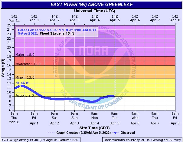
Isn't the saying, "April showers bring May flowers"? Well, we certainly have been experiencing some overcast and rainy days. But that just means spring is right around the corner! Although, it also means that the East River has swollen and has the potential for flooding. When soils are saturated there is less room for more water to infiltrate and a normal rainfall has potential to cause tremendous flooding. Keep a watchful eye! | |
Hydrograph of the East River gauge at the intersection of Eiler Rd. Colors represent flood stages. Yellow = action stage where flood mitigation may become necessary, orange = flooding with minimal to no property damage, red = some inundation of roads or structures near river, purple = extensive flooding and evacuations may be required. Credit: National Weather Service | |
|
This past month has flown past since we have been working on coordinating with municipalities to touch base with how the East River Resilience project is coming along, results from community resilience questionnaires, and to answer any possible questions that may have come up. The East River Resilience Coordinator will be attending a number of board meetings to present on these topics.
We have been working with Brown County to complete one of these community resilience questionnaires as well! It will be a great asset to get their higher-level perspective of how and why flooding occurs as well as the impacts of flooding along the East River. Their perspectives come from zoning, agricultural areas, GIS, and emergency management.
Lastly, in working with the UW-Madison Cartography Lab, we have nailed down a few maps that we will be using to print off and bring with us to community events. They include a map of the watershed with flood extent at the different probability rain events such as the 1yr, 10yr, 100, and 500yr events. Another one that will demonstrate the effect lake levels have on flooding and other local maps depending on the community we are visiting. Later, we will be talking about how we can create an interactive map.
| |
|
Partner Spotlight: UW-Madison Cartography Lab
As mentioned in this and previous newsletters, we are working with the UW Cartography Lab to create maps that allow for greater accessibility to the data we have produced from our flood modeling study of the East River watershed. Here is a link to our current map. We have been working with two fantastic individuals there, Tanya Buckingham, Creative Director of the Cart Lab, and Jacob Steinberg a Master's student in GIS and Cartography. They have helped us take a variety of layers such as flood extent, community infrastructure, roads, green spaces, etc., and put it into a visually pleasing format which we will use for community outreach, education, and vulnerability visualization.
The UW Cartography Lab has been around since 1953, functioning as a "center of innovation for map design, interactive visualization, and geographic thinking". It brings together researchers, professional designers, and students to create exceptional geographic visuals - maps. A map, similar to a picture, says 1000 words and more. "Maps tell stories. Maps provide explanations. Maps make arguments". Maps become essential to how spatial information can be disseminated, how residents may feel included or excluded from a community, and even influencing how our president is chosen.
The Cart Lab also works with government agencies, scholars, instructors, as well as the UW system to meet the cartographic and design needs of a particular project. The Lab functions, in a sense, as a "maker-space" where production, research, and educational activities are integrated. A unique aspect of the Cart Lab is that each project and each partnership allows for students to serve in apprenticeships - to have real-world experiences, discuss and address complex geographic problems, and create visuals that encourage place-based dialogue.
Check out their website here.
| |
|
Report: Wisconsin Initiative on Climate Change Impacts (WICCI) - 2021 Assessment Report: Wisconsin's Changing Climate
In the 10 years since the 2011 WICCI Assessment Report, new data show continued warming, increases in rain and snow, and more frequent extreme rainfall events. This report explains the issues and impacts of our warming climate on Wisconsin residents and describes the scientific progress made toward solutions. It also features summaries of the latest science produced by each WICCI Working Group, links to interviews and stories of climate impacts in Wisconsin, and links to more detailed information on each working group webpage. Read the full report here.
| |
|
Sustain Our Great Lakes 2022 grant proposal
Full proposal due: April 18, 2022, by 11:59 pm ET
The National Fish and Wildlife Foundation, Sustain Our Great Lakes (SOGL) program is soliciting proposals to benefit fish, wildlife, habitat, and water quality in the Great Lakes basin. Grant funding will be awarded in six categories: restore and enhance stream and riparian habitat, restore, and enhance coastal habitats, expand green stormwater infrastructure in great lakes communities, maintain and enhance benefits of habitat restoration through invasive species control, restore and preserve natural areas and biodiversity of Wisconsin’s Lake Michigan Watershed, and accelerate the implementation of conservation practices and regenerative agriculture on working lands. Find the program overview and related details here.
| |
|
RFP: 2022 National Coastal Resilience Fund (NCRF)
Pre-proposals due: 10:59 pm CST on April 21st, 2022
The National Fish and Wildlife Foundation (NFWF) and the National Oceanic and Atmospheric Administration (NOAA) are accepting pre-proposals for the 2022 NCRF Request for Proposals. NFWF will invest approximately $140 million in grants to support the planning, design, and restoration of natural and nature-based solutions to help protect coastal communities from the impacts of storms, floods, and other natural hazards and enable them to recover more quickly and enhance habitats for fish and wildlife. The funding is a combination of Infrastructure Act (IIJA) and annual appropriations funding. Contact Stephanie Bailenson, s.bailenson@TNC.ORG, if you are interested in submitting a proposal or have any questions.
| |
|
RFP: Great Lakes Sediment and Nutrient Reduction Program
Pre-proposals due: 4:00pm CST on April 22, 2022
The Great Lakes Commission has issued a request for proposals for the 2022 Great Lakes Sediment and Nutrient Reduction Program grant program. For more than 30 years, this program has provided grants to reduce nutrients and sediments from entering the Great Lakes. This year’s program will continue to help local partners take action to reduce nutrient loads from agricultural watersheds, reduce untreated stormwater runoff, and restore shoreline and streambanks in the Great Lakes basin. Applicants are invited to submit proposals for activities associated with one of three project types: 1) agricultural nonpoint; 2) stormwater; and 3) Great Lakes shoreline or streambanks. Find more details here.
| |
|
NRCS Watershed Program Resources
Deadline: Ongoing
The U.S. Department of Agriculture (USDA) is encouraging local sponsors to submit project requests for funding through the Infrastructure Investment and Jobs Act. USDA’s Natural Resources Conservation Service (NRCS) offers several programs to help communities improve land and water resources within watersheds as well as relieve imminent hazards to life and property created by a natural disaster. Funding is available for new projects as well as those already submitted to NRCS. NRCS will give additional consideration to projects in historically
underserved communities that directly benefit limited resource areas or socially disadvantaged communities. More information at this link.
| |
|
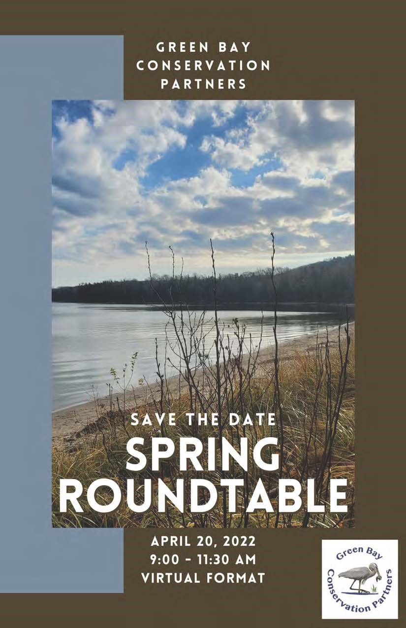
Virtual event: Green Bay Conservation Partners Spring Round Table
April 20th, 2022 | 9:00 - 11:30am CST
Please register by April 18!
This will be an exciting event to share information and foster collaboration among conservation practitioners, researchers, and stakeholders working in the bay of Green Bay, Lower Fox River watershed, Green Bay’s west shore and Door Peninsula. The morning includes an opportunity for networking, regional and legislative updates, lightning talks, and student posters. Don’t miss this great opportunity to hear from partners involved in exciting restoration, monitoring, and other conservation projects around the region. Please contact Amy Carrozzino-Lyon, gbconservationpartners@gmail.com, (920) 465-5029, with questions.
| |
|
Webinar: Going Green for Good: Long-Term Considerations for Operations and Maintenance of Green Infrastructure
Thursday, April 28, 2022 | 1:00 pm - 2:30 pm CST
Construction of green infrastructure is only one step toward successful implementation. Like all stormwater infrastructure, green infrastructure practices must be inspected and maintained to ensure proper performance. Three speakers will highlight successful municipal approaches to green infrastructure O&M. Join EPA's Green Infrastructure Webcast Series to discuss O&M planning considerations and practices that will help communities cost-effectively achieve the environmental, economic, and social benefits of green infrastructure for years to come.
Speakers
Dr. James Houle - University of New Hampshire Stormwater Center
Leslie Schehl - Metropolitan Sewer District of Greater Cincinnati
Peter Schultz-Allen - EOA, Inc.
| |
|
Climate Intersections Conference: Taking care of people, water, and the land
Dates: July 12-14th, 2022
Location: Duluth, MN
The North Central Region Water Network is hosting a regional in-person conference exploring the ways climate intersects with our lives, our water and our land July 12-14th in Duluth, Minnesota. The Climate Intersections Conference will feature emergent research and highlight key programming on climate's impact on our agricultural systems, communities, and watersheds. Find more info about the conference here.
| |
|
The East River Resilience Collaborative (ERRC) is a community of practice committed to increasing flood resiliency in Wisconsin’s East River Watershed by improving the collaborative capacity of its stakeholders. The ERRC is comprised of local, county, state, and federal officials, as well as representatives from various regional organizations, non-profits and the UW system. Learn more about the ERRC here.
Please direct any questions or concerns, as well as content for future newsletters to Kayla Wandsnider.
| | | | |