November 2024

Looking for Your Name in Landsat

November 25, 2024

Ally Nussbaum and Ross Walter with their favorite Landsat letters.

More than 715,000 visitors have transcribed their names and messages into Landsat letters using the “Your Name in Landsat” tool since it was unveiled in August as part of Camp Landsat 2024. Enthusiasm for the tool spread quickly as it captivated folks on social media and was featured in Hackaday and Forbes. A new Q&A reveals how the popular Landsat letter tool came to be.

How We Found the Letters
Sanaa, Yemen and surrounding regions, including the airport to the north and mountains on either side. The image is mostly brown and grey, with very little green space in or around Sanaa.

November 26, 2024

Cities in the Global South Lack Green Space


As any urban dweller who has lived through a heat wave knows, a shady tree can make all the difference. But what happens when there’s no shade? A recent study used Landsat data to find that cities in the Global South have far less green space than cities in the Global North. 

Brad Doorn speaks during NASA’s “Space for Ag” roadshow in Iowa, July 2023, highlighting NASA’s role in supporting sustainable farming practices. Credit: N. Pepper

November 20, 2024

NASA's Brad Doorn Brings Farm Belt Wisdom to Space-Age Agriculture

Source: Emily DeMarco, NASA’s Earth Science Division, Headquarters


From his South Dakota roots to leading NASA’s agricultural program, Brad Doorn’s mission has remained the same: help farmers feed the world.

Image shows bathymetry measurements around Key West, Florida. Shallower regions around the Key are in light green, whereas deeper waters are in dark blue

November 4, 2024

Landsat Plumbs the (Shallow) Depths

Source: Lindsey Doermann, NASA’s Earth Observatory


Scientists at the U.S. Geological Survey have developed a new way to measure ocean depth, or bathymetry, in shallow nearshore environments using Landsat data. This up-to-date information is critical for modeling water movement, tracking coastal changes, studying coral reef habitats, and more.

As cool as the 'Your Name in Landsat' tool is, it highlights a very important mission and contribution to society.


Marshall Shepherd, Director of the University of Georgia’s Atmospheric Sciences Program, August 31, 2024

A NASA Tool Can Spell Your Favorite Team Name With Earth Images; Forbes

Upcoming Events

The Landsat Communications and Public Engagement Team will be at the following event in December 2024:

Logo for the AGU annual meeting. Text reads: AGU24, Washington, D.C. 9-13 December.

American Geophysical Union


December 9-13, 2024

Walter E. Washington Convention Center

Washington, DC


The Landsat team will be at the NASA booth on

12/10 from 12pm-4pm

12/12 from 10am-1pm


Landsat 8 and 9 Project Scientist Chris Neigh will present about Landsat's Emerging Applications at

Poster Session: 12/9 from 8:30am-12:20pm

Oral Session: 12/9 from 4pm-5:30pm

PUBLICATION SPOTLIGHT


Global potential for natural regeneration in deforested tropical regions


| Williams et al., 2024


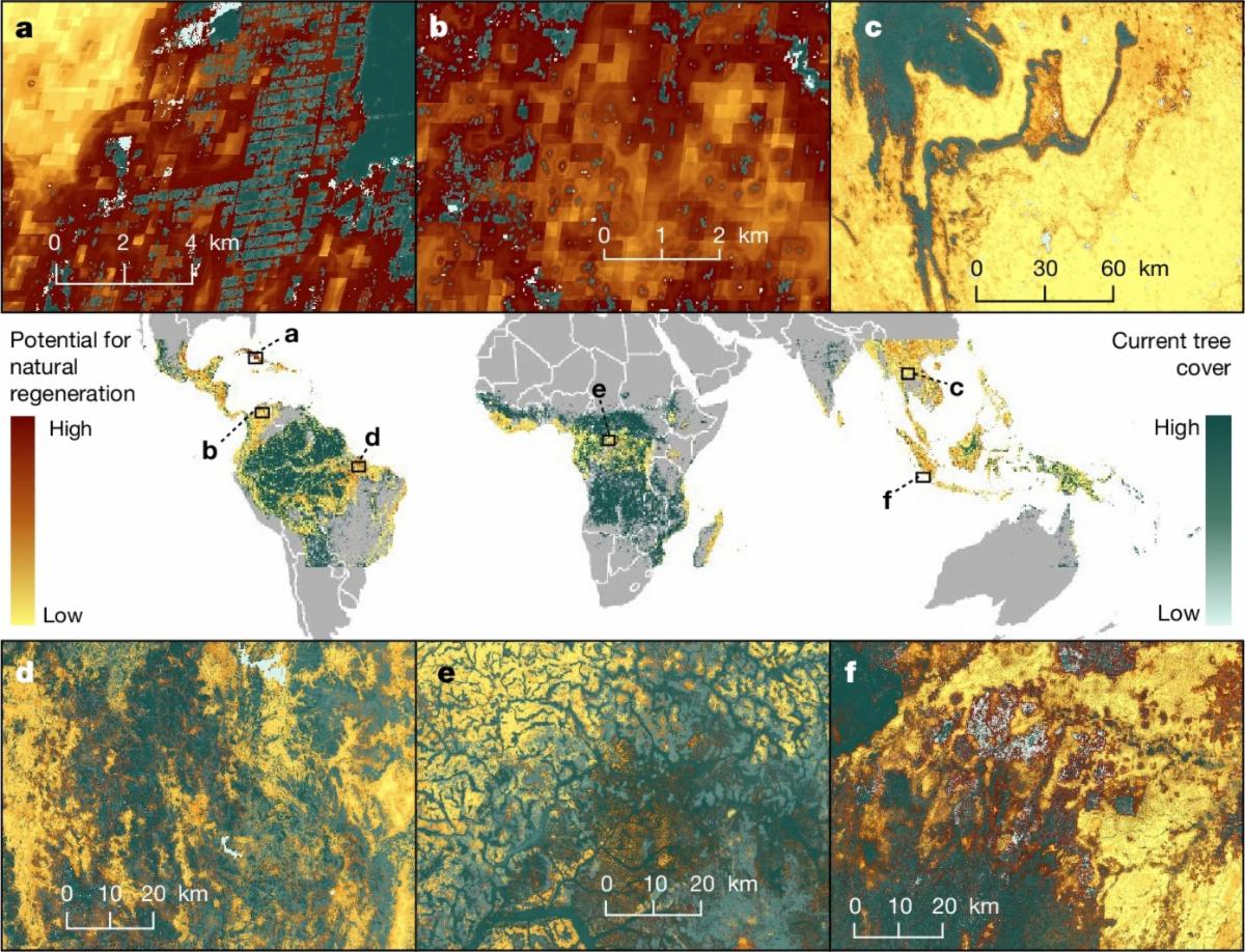
In the face of decades of intense deforestation, forest restoration is a critical strategy for conservationists safeguarding biodiversity, storing carbon, and sustaining nearby communities. However, planting trees is costly, time-intensive, and often results in less biodiverse forests than natural regeneration. Researchers in Williams et al., 2024 used a Landsat-derived tree cover database and a range of biological and socioeconomic factors—ranging from land cover to climate data to road density—to build a model of where natural tropical forest regeneration occurred from 2000 to 2016. The model accuracy for classifying regrowth patches as plantation, open, or natural regrowth was 90.6%. Then, they modeled future natural regeneration across tropical forests, finding that 215 million hectares (over 530 million acres) have the potential for natural forest regeneration. If reforested, that land—larger than the entire country of Mexico—could sequester around 23.4 gigatons of carbon over the next 30 years. Over half of that land is in five countries: Brazil, Indonesia, China, Mexico, and Colombia.

A global map of the potential for natural regeneration in the global topics and subtropics, with inset maps showing areas of high potential natural regeneration.

The potential for natural forest regeneration in the global tropics and subtropics. Dark brown represents areas of high potential for natural regeneration, yellow represents areas of low potential for natural regeneration, and green represents current tree cover. Image credit: Williams et al., 2024

Find more selected Landsat publications on our website.

NASA Earth Observatory

Selected Landsat Images

November 19, 2024

Mount Fuji Bare Again After Fleeting Snow


The volcano’s first snow of the season fell in early November 2024—the latest in a 130-year record—only to apparently vanish within a few days.

A natural-color Landsat 8 image of Mount Fuji after snow had melted, acquired on November 9, 2024.

November 18, 2024

Signs of Sea Level Rise in the Bahamas


Rising seas have redistributed cyanobacterial mats blanketing part of Andros Island and restructured the island’s marshes and mudflats.

A pair of Landsat images highlighting changes in the distribution of bacterial mats and channels in the shallow tidal zone of the Three Creeks area in the northern part of the island. The TM (Thematic Mapper) on Landsat 5 captured the left image on April 29, 1986. The OLI-2 (Operational Land Imager-2) on Landsat 9 captured the right image on May 15, 2024.

November 16, 2024

Antarctic Icebergs Show Their Colorful Undersides


The blue underbellies of icebergs were spotted floating near the Amery Ice Shelf.

A natural-color Landsat 9 satellite image of blue icebergs near the Amery Ice Shelf in Antarctica. Text in this image pinpoints Antarctica, penguin guano, sea ice, and three flipped icebergs. This image was acquired on October 26, 2024.

November 7, 2024

Mount Lewotobi Laki-Laki Spews Ash


Eruptions in November 2024 sent volcanic material over the Indonesian island of Flores.

The false-color image, acquired by the OLI-2 (Operational Land Imager-2) on Landsat 9, shows Laki-Laki on November 5, 2024. The landscape to the west of the crater was darkened by ash fallout from the recent eruptions.

Did someone forward this newsletter to you? Subscribe here if you'd like to be on our mailing list.

landsat.gsfc.nasa.gov

Facebook  X