Dear Florida Climate Center Friends, |
We'd like to present you with the Fall 2022 edition of our quarterly newsletter. In this newsletter, you'll find our most recent monthly climate summaries for the past three months; an update on the La Niña Advisory and drought status; a recap of the 2022 Atlantic hurricane season; and the upcoming seasonal outlook. You will also find an update on events and activities we've been engaged in. If you have any questions, please send us an e-mail at [email protected].
Thanks,
The Staff of the Florida Climate Center
|
|
|
Monthly Climate Summaries for Florida |
The Florida Climate Center's September, October, and November Climate Summaries for Florida are available, as well as previous monthly summaries. These summaries provide an analysis of temperature and precipitation patterns across the state, along with data on hazardous weather, drought, and daily records tied or broken each month.
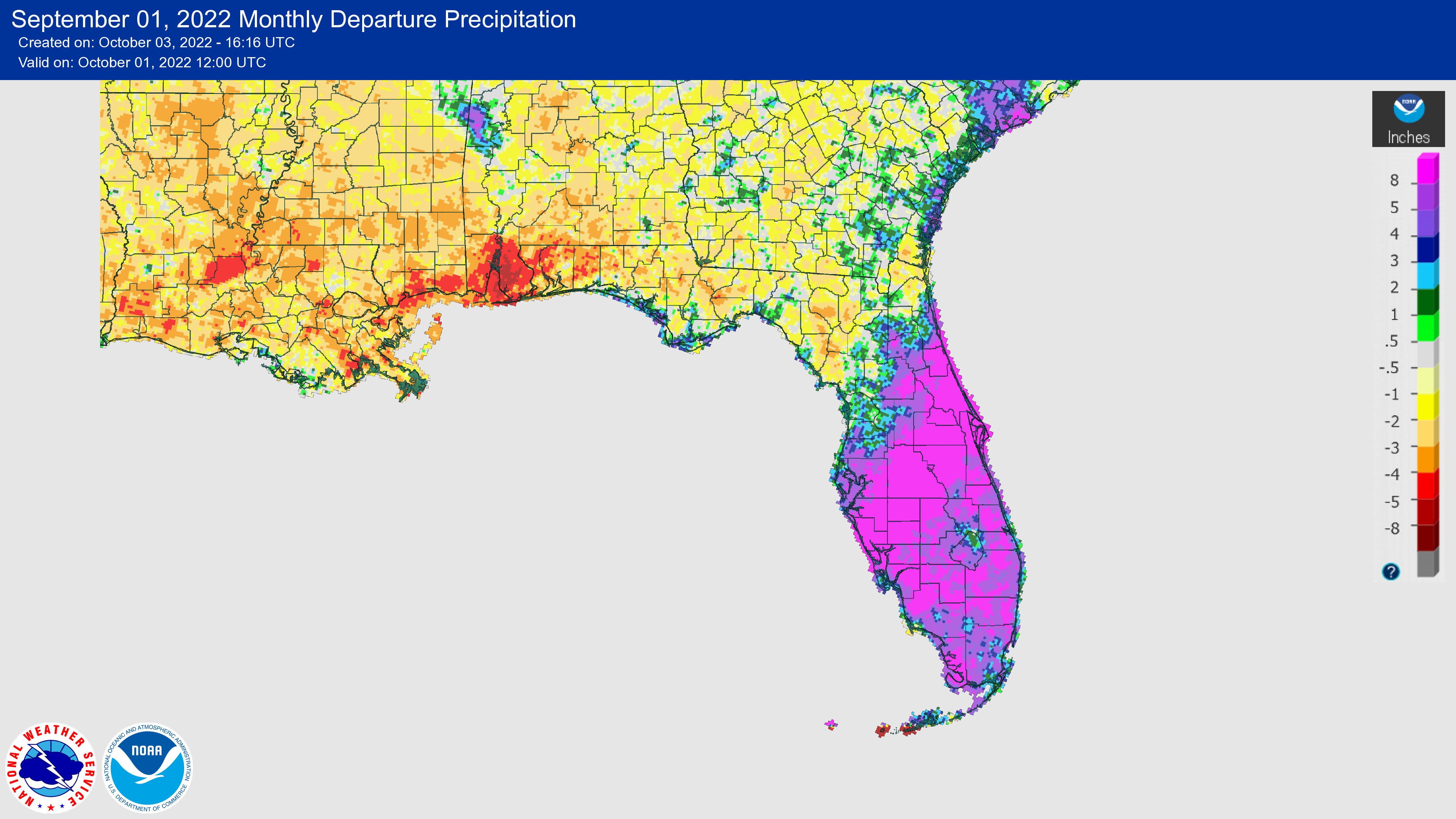
Average temperatures in September were near normal across the state. The monthly departures from normal ranged from -1.8 ̊F in Sarasota to +1.5 ̊F in Orlando. Southeast Florida was particularly warm and Miami recorded its warmest September on record, based on the monthly average maximum temperature.
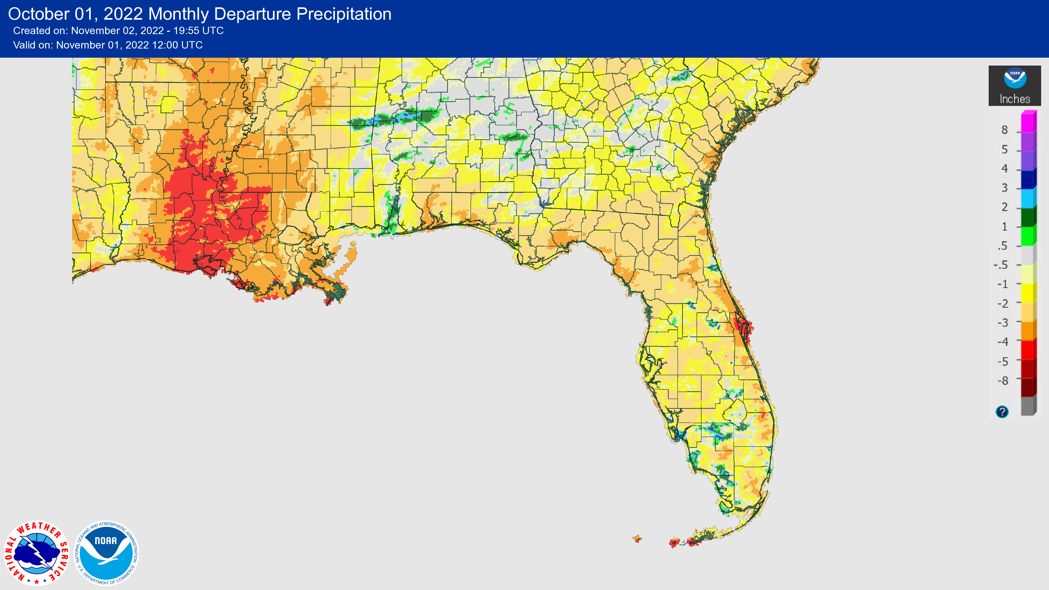
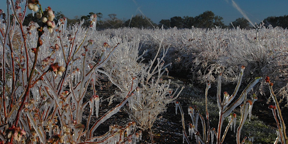
October was cooler and average monthly temperatures were generally below to near normal. Monthly mean temperature departures from normal ranged from -3.1 ̊F in Tallahassee to +0.4 ̊F in Miami. A strong trough reached the southeastern U.S. during the middle part of the month from the 19th-22nd, which brought arctic air to northern Florida. On the 20th, Tallahassee recorded a daily record low temperature of 31 ̊F, which was 26 ̊F below normal for this date.
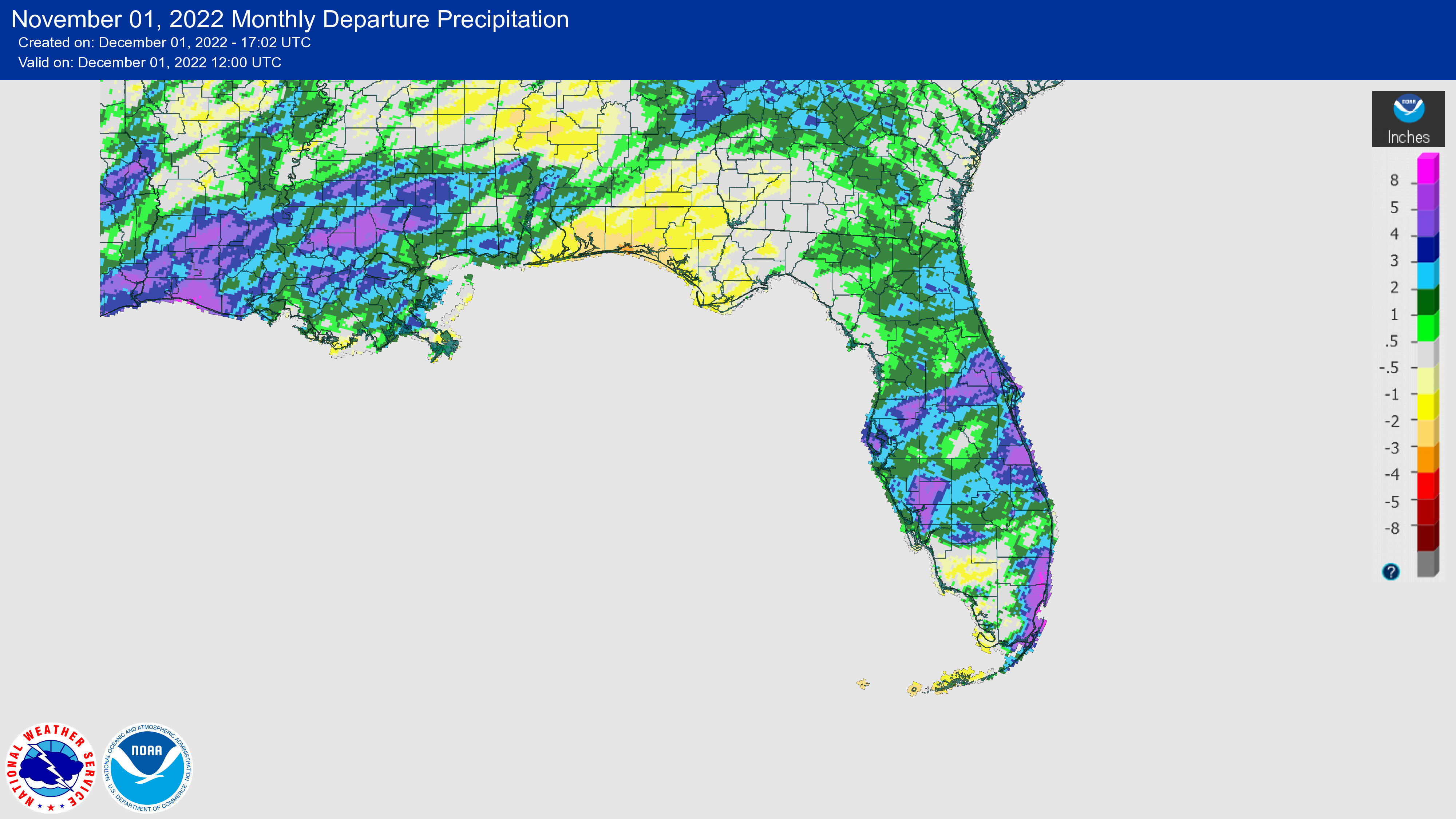
Average monthly temperatures in November were above normal. Monthly mean temperature departures from normal ranged from +2.7 ̊F in Key West to +5.1 ̊F in Fort Myers. Many locations had one of their top 5 warmest Novembers on record, including Miami (2nd-warmest), Naples (2nd-warmest), Fort Myers (3rd-warmest), Orlando (4th-warmest), Vero Beach (4th-warmest), and Key West (5th-warmest).
The figures below are graphical depictions of the monthly rainfall departure from normal (in inches) for September, October, and November (courtesy of the National Weather Service). In September, Hurricane Ian brought over 20 inches of rain in parts of central and eastern Florida. This was followed by below normal rainfall in October and drought development in the Panhandle. November saw excess rainfall across the Peninsula due to Hurricane Nicole.
|
|
2022 Atlantic Hurricane Season Recap |
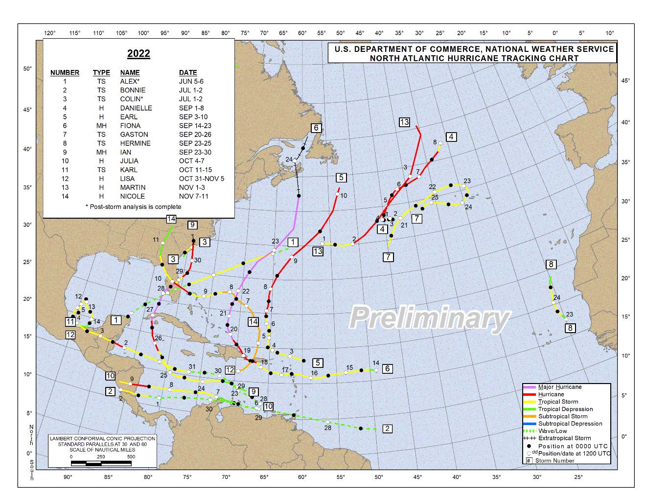
The 2022 Atlantic hurricane season officially ended November 30. It was a near-average season overall, with slightly below-average levels of ACE (Accumulated Cyclone Energy). In total, there were 14 named storms, 8 hurricanes, and 2 major hurricanes; 6 of these storms affected the southeastern U.S.
After three early season storms, July and August were quiet with no named storms between July 3 and August 31 - the first time since 1941 with no named storms during these dates. This officially put the season below, or behind, normal at that time. In early August, official forecasts were modified to decrease the total number of storms predicted for the season.
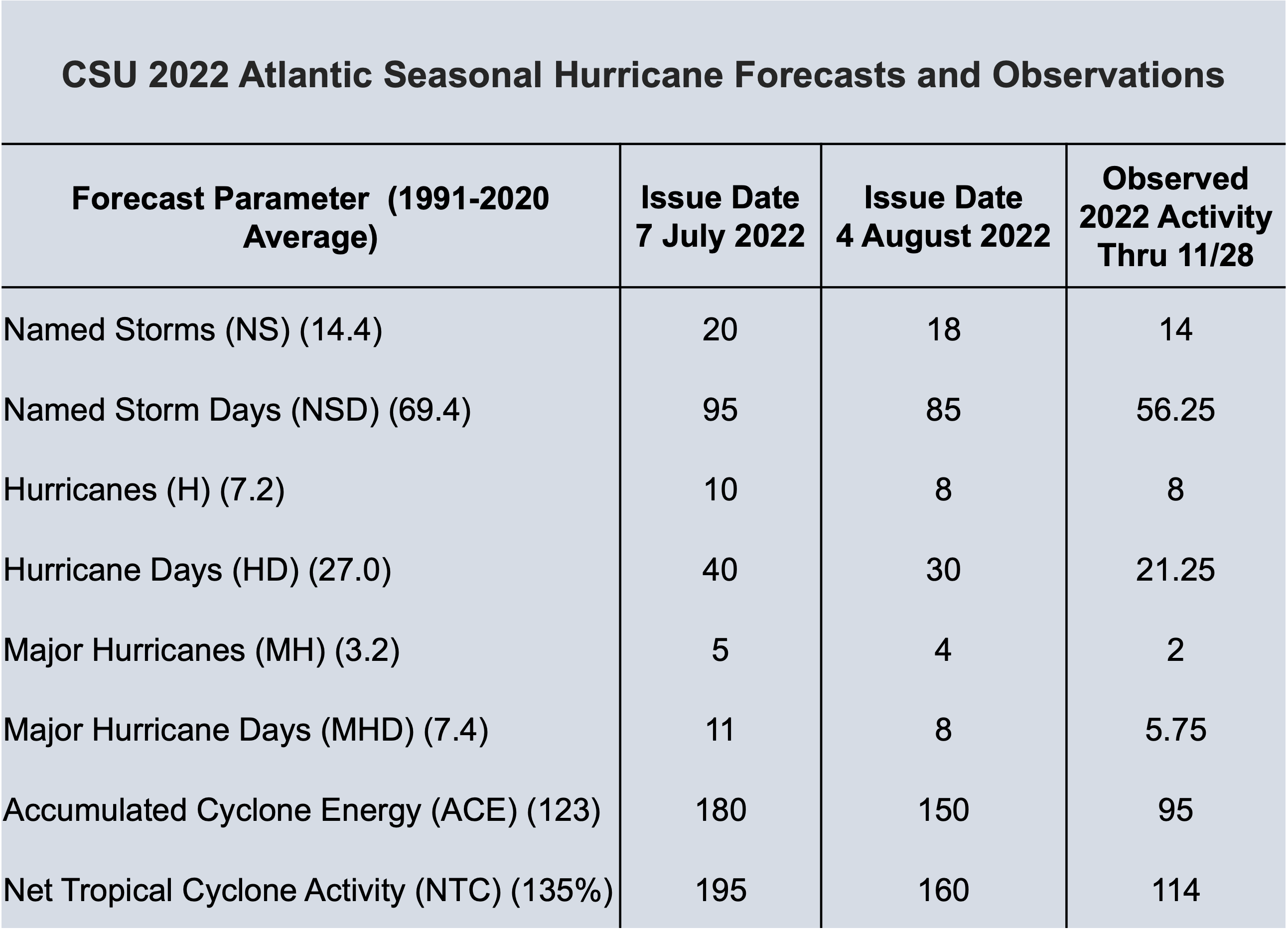
Colorado State University (CSU) has released their hurricane season verification report (see table below). The total number of named storms and hurricanes verified well and were near the 1991-2020 averages, but the season was below normal based on other metrics like ACE, number of major hurricanes, and number of hurricane days.
Hurricane Ian was the most impactful hurricane of the Atlantic 2022 season, which caused over 130 U.S. fatalities and at least $50 billion in damages. Read our Hurricane Ian summary report for more information. Hurricane Fiona also caused significant impacts in Puerto Rico and Canada's Atlantic provinces and had the lowest central pressure (about 931 mb) recorded for a landfalling storm in Canada on record.
|
|
Figure: 2022 Atlantic basin tropical cyclone tracks through November 28, courtesy of NOAA. |
|
Table: 2022 Atlantic seasonal hurricane forecasts and observations issued by Colorado State University (data from Klotzbach et al. 2022 summary report). |
|
Drought Status in Florida |
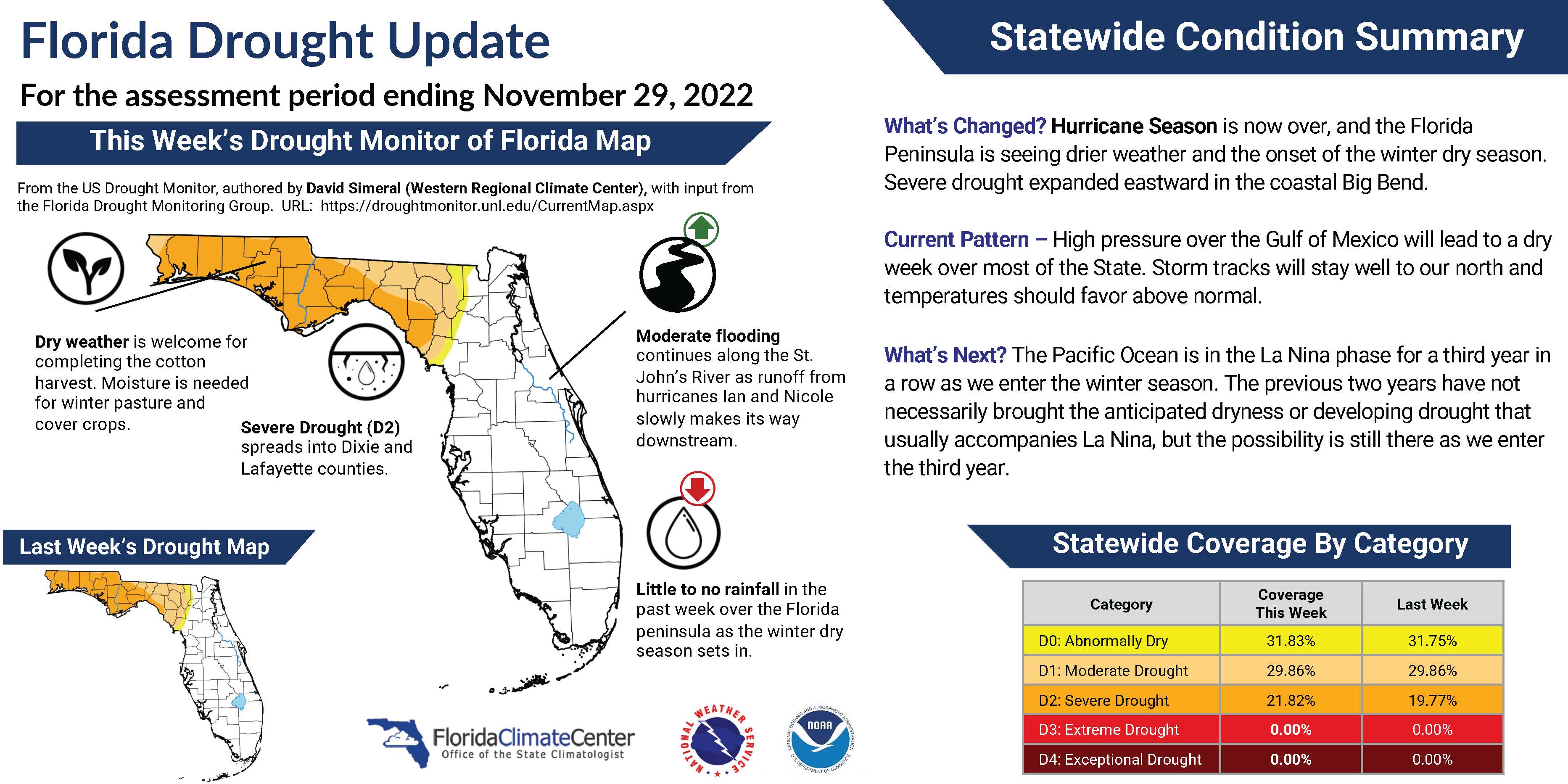
September began with abnormally dry conditions in southeast Florida, with areas of moderate drought along southeastern coastal areas. Drought dissipated in southeast Florida as Hurricane Ian brought excessive rainfall to the Florida Peninsula. Drought development occurred in the western Panhandle in early October, and expanded across the Panhandle throughout October and persisted through November. At the end of November, all of the Panhandle was experiencing moderate to severe drought conditions. |
|
La Niña Advisory: Third Consecutive Winter Expected
|
La Niña conditions, the cool phase of the El Niño-Southern Oscillation (ENSO) climate pattern, are forecasted to persist across the tropical Pacific for the third winter in a row, with a 76% chance from December through February. A transition to ENSO-neutral conditions is favored (57% chance) in February to April 2023. The continuation of La Niña is expected to influence winter weather. The previous two years have not necessarily brought the anticipated dryness or developing drought that usually accompanies La Niña, but the possibility is still there as we enter the third year.
|
|
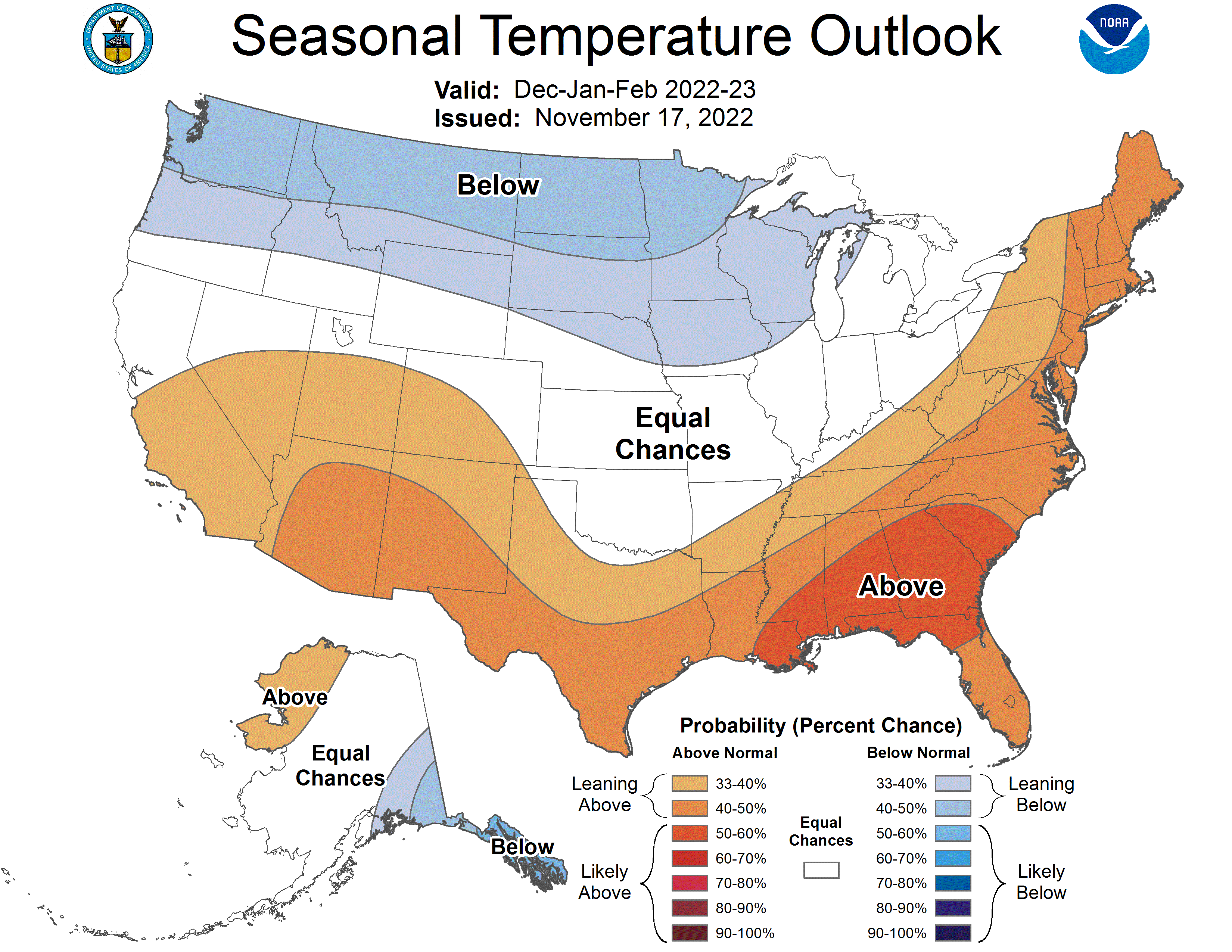
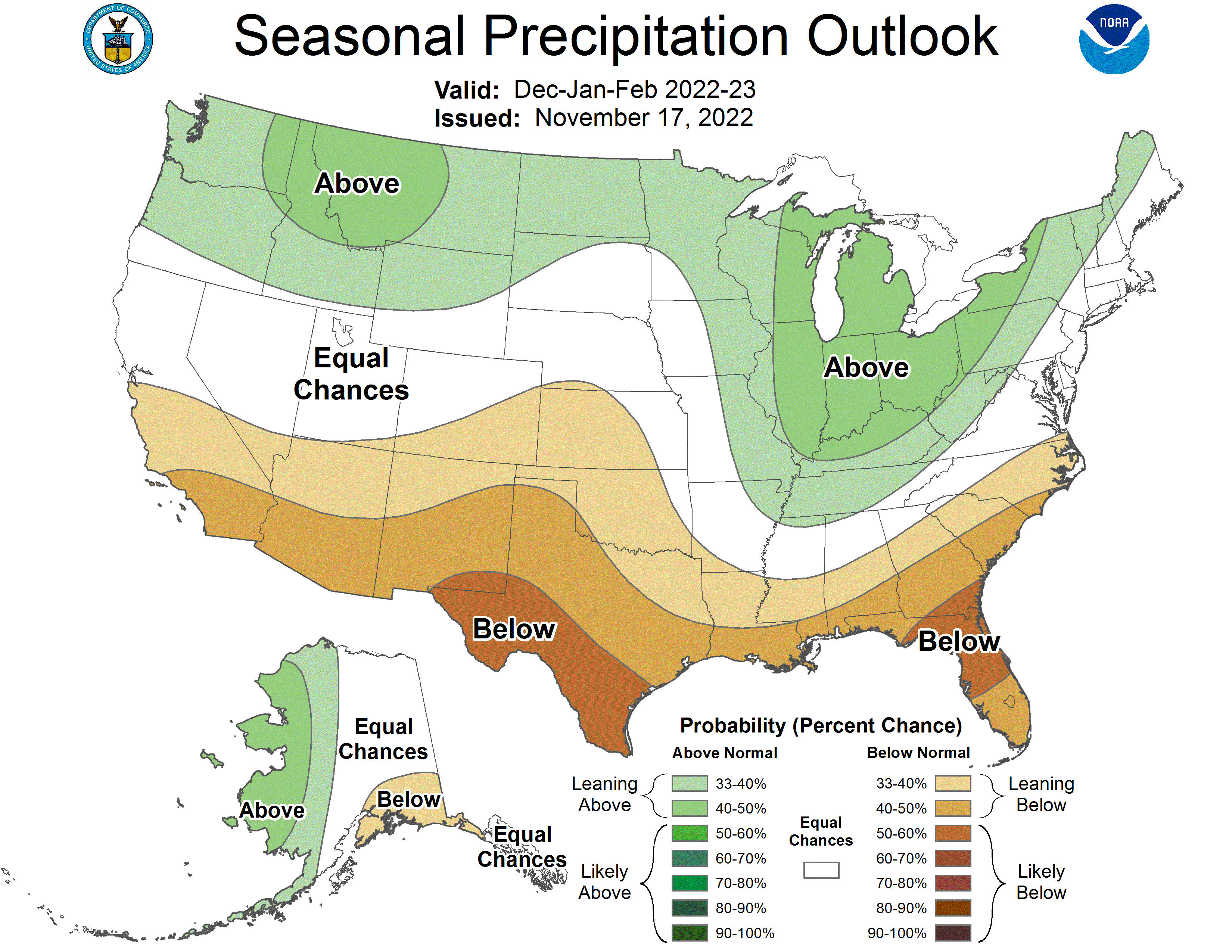
The Seasonal Outlook for Winter is Leaning Warmer and Drier than Normal for Florida |
NOAA's Climate Prediction Center anticipates a warmer than normal winter season this year, from December through February, for Florida and the Southeast U.S. Northern Florida has greater chances for observing above-average temperatures (between 50-60% chance). Precipitation is leaning below normal across Florida, with northern and central Florida having a 50%-60% chance of below normal precipitation this winter. |
|
Tri-State Row Crop Working Group Meeting, Quincy, FL, September 9, 2022
The Tri-State Row Crop working group met in Quincy for a 1-day workshop on "Global Shocks, Flash Droughts, and Perennial Peanut". David Zierden provided a seasonal climate review and forecast.
|
|
Florida Water and Climate Alliance Webinar, virtual, October 27, 2022
|
This webinar discussed the impacts of extreme weather and climate on Florida water agencies. David Zierden presented on climate variability and trends in Florida and impacts on water resources. |
|
|
UF/IFAS Winter Weather School, Tavares, FL, November 30, 2022
|
The UF IFAS winter weather school provided a series of presentations on strategies for freeze protection, the Florida Automated Weather Network data and tools, and cold tolerant crops and cultivars. David Zierden presented on trends in Florida's winter weather and the climate outlook. |
|
|
Southeast Climate Monthly Webinar Series
This webinar series, hosted by the Southeast Regional Climate Center in partnership with the National Integrated Drought Information System (NIDIS) and the NOAA National Weather Service, is held on the 4th Tuesday of each month at 10am ET. The next webinar is January 24, 2023. The special topic will be a 2022 Year in Review by Karin Gleason with the National Centers for Environmental Information. Register here.
|
|
The Florida Climate Center is part of a three-tiered system of national, regional, and state climate offices, including NOAA's National Centers for Environmental Information (NCEI - in Asheville, North Carolina) and the Southeast Regional Climate Center (in Chapel Hill, North Carolina). The Florida State Climatologist and staff at the Florida Climate Center provide the following information and services to the people of Florida:
Climate Data
Historical weather observations for weather stations throughout the state of Florida. We are able to provide data for most stations from 1948-present.
Climate Information
Long-term historical averages for various stations, climate divisions, and the entire state.
Extreme Event Records
Information and analyses on extreme events such as freezes, droughts, floods and hurricanes.
Special Analysis
With their vast knowledge of El Niño, La Niña and climate variability, the State Climatologist and staff can offer expert insight into Florida's climate trends.
Outreach
Activities, presentations, and workshops that inform and educate the people of Florida about current and emerging climate issues. We also coordinate volunteers for the Community Collaborative Rain, Hail & Snow Network (CoCoRaHS).
|
|
Florida Climate Center | Florida State University | [email protected] | (850) 644-3417
|
|
|
|
|
|
|