Dear Florida Climate Center Friends, |
We'd like to present you with the Spring 2021 edition of our newsletter. In this newsletter, you'll find our monthly climate summaries for the months of February, March and April; the latest ENSO forecast; the recently released 2021 Atlantic hurricane season outlook; information on the new climate normals for Florida; current wildfire season activity; and an update on news and activities we've been engaged in. If you have any questions, please send us an e-mail at [email protected].
Thanks,
The Staff of the Florida Climate Center
|
|
|
Monthly Climate Summaries for Florida |
The Florida Climate Center's February, March, and April Climate Summaries for Florida are available. These summaries provide an analysis of temperature and precipitation patterns during the months of February through April across the state, along with data on hazardous weather, drought, and any records tied or broken.
In February, average temperatures were above normal across Florida. Departures from normal ranged from +0.2 ̊F in Key West to +5.8 ̊F in West Palm Beach. Many daily high maximum and high minimum records were set throughout the month. In March, average temperatures remained well above normal across the state. Monthly departures ranged from +1.9 ̊F in Miami to +4.8 ̊F in Pensacola, with even warmer daily departures from normal observed in mid to late March. During April, average temperatures were below normal across much of north Florida and above normal in the south, ranging from -1.3 ̊F in Jacksonville to +2.4 ̊F in Key West.
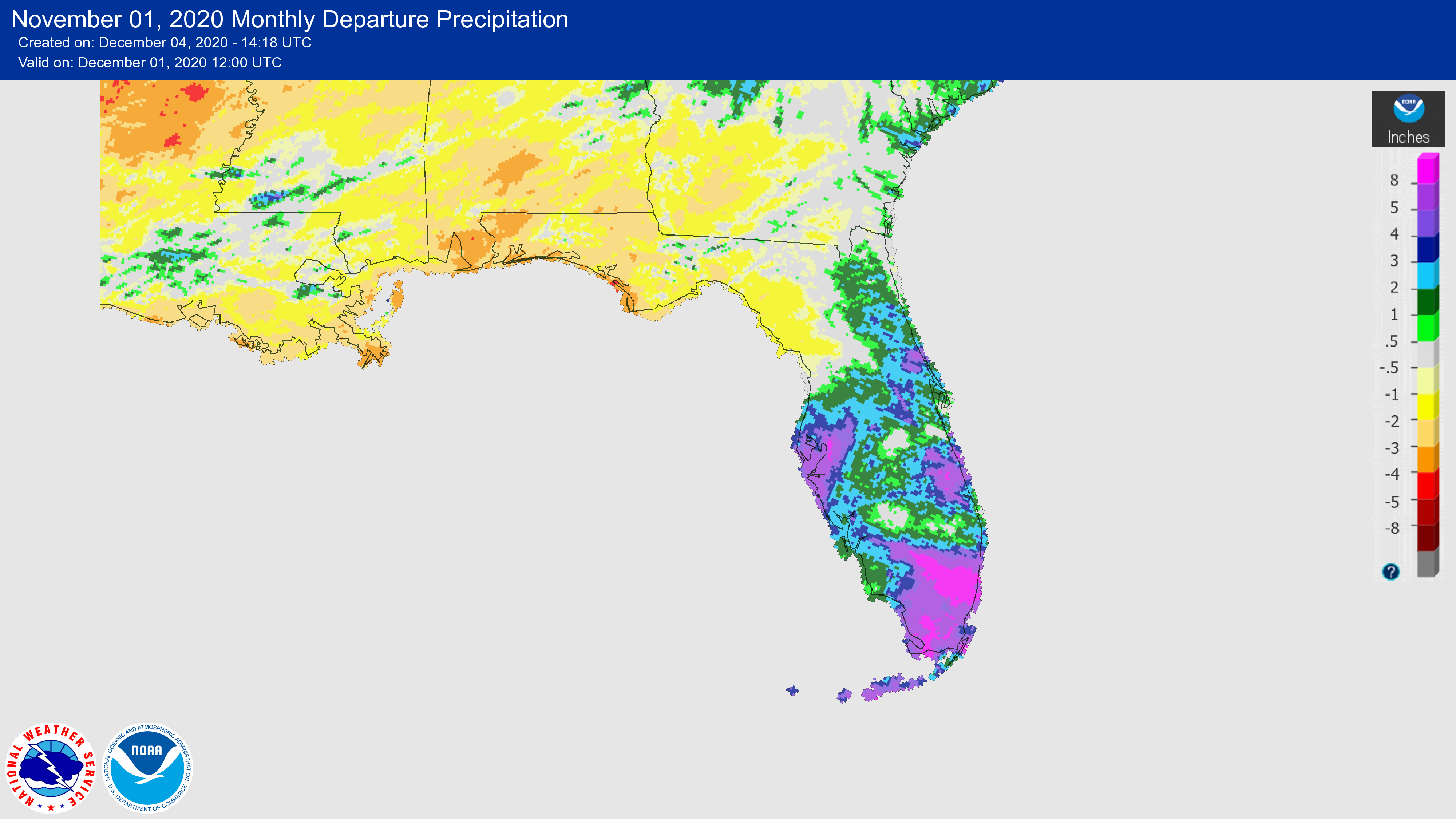
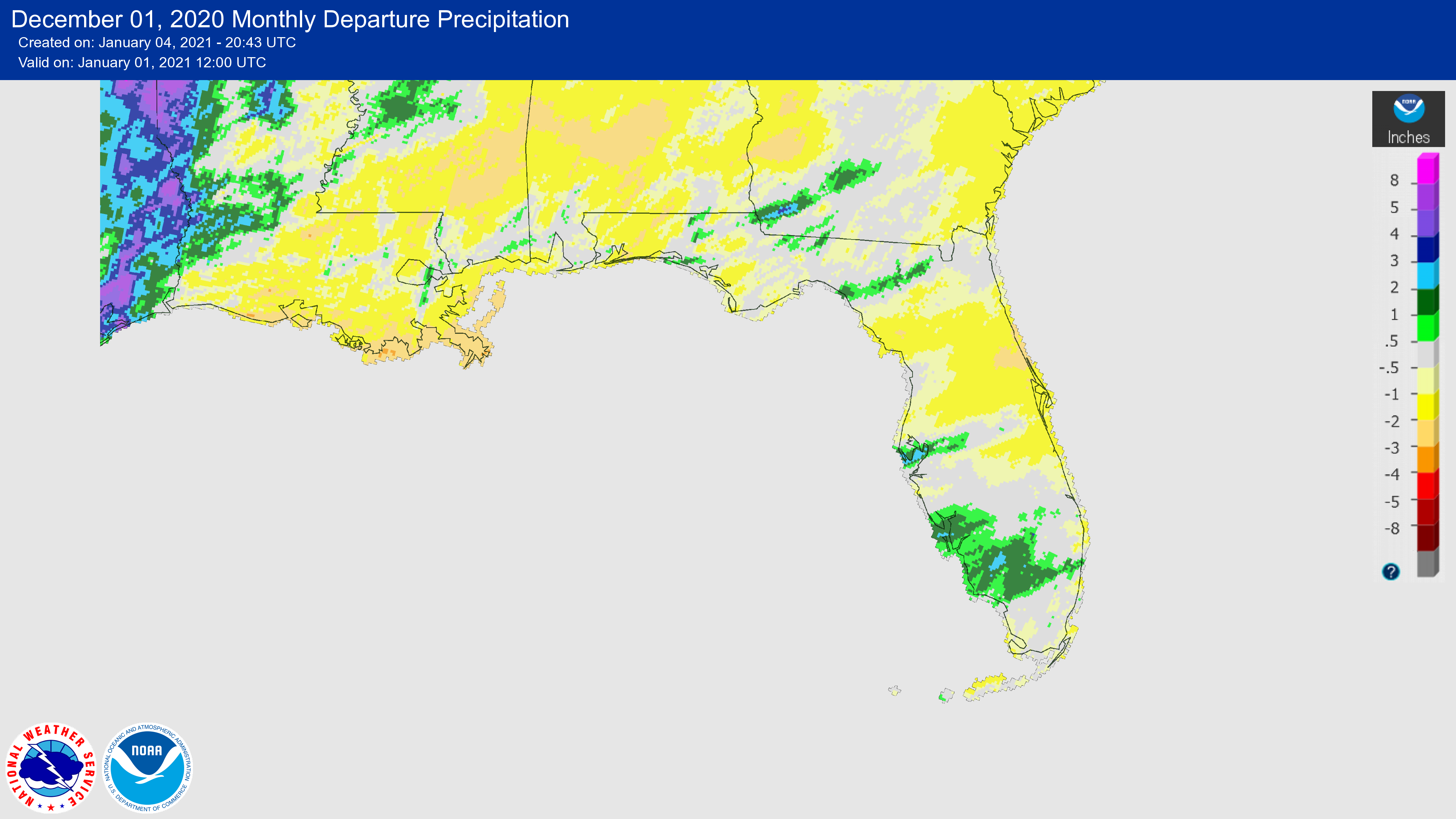
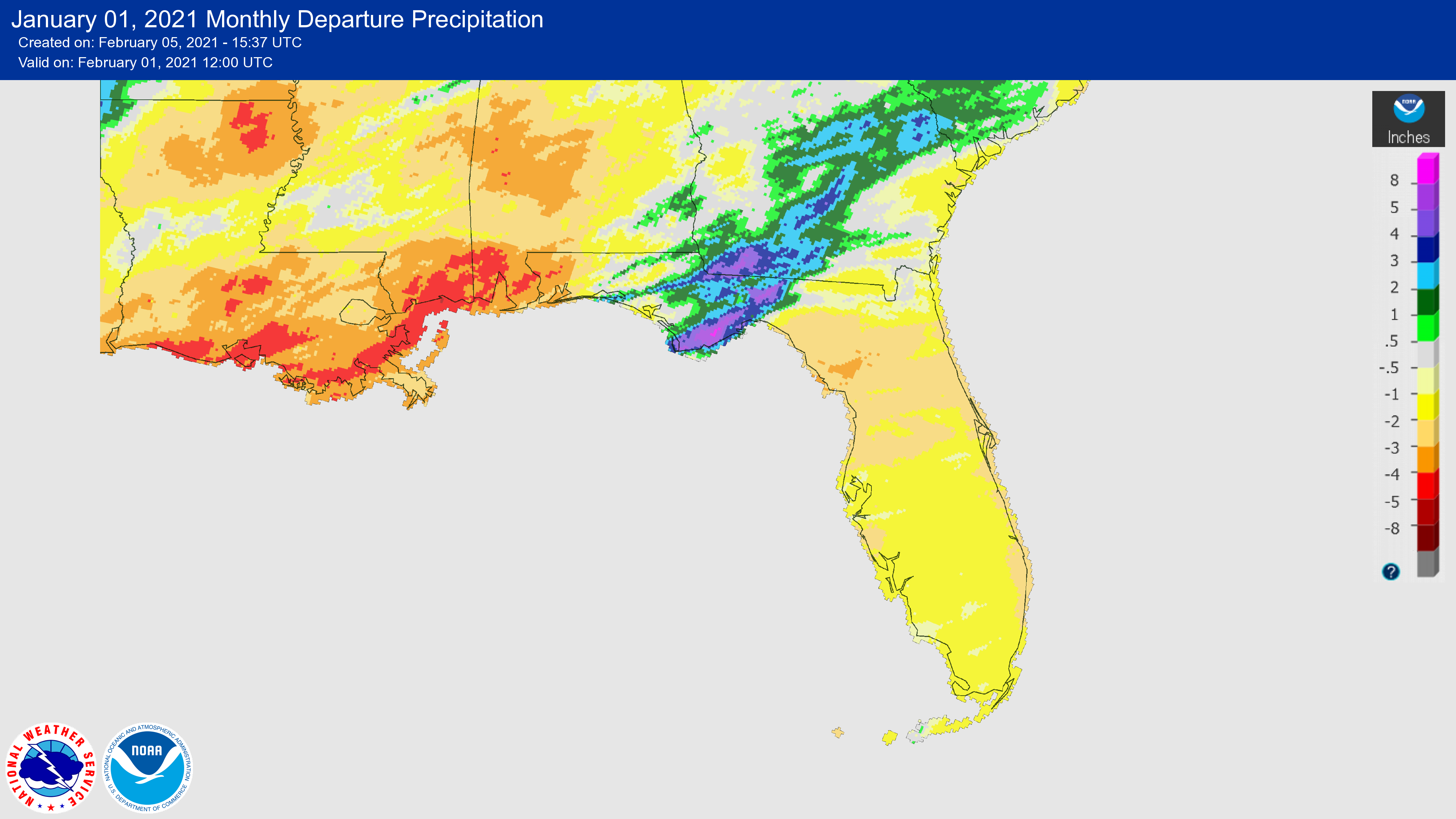
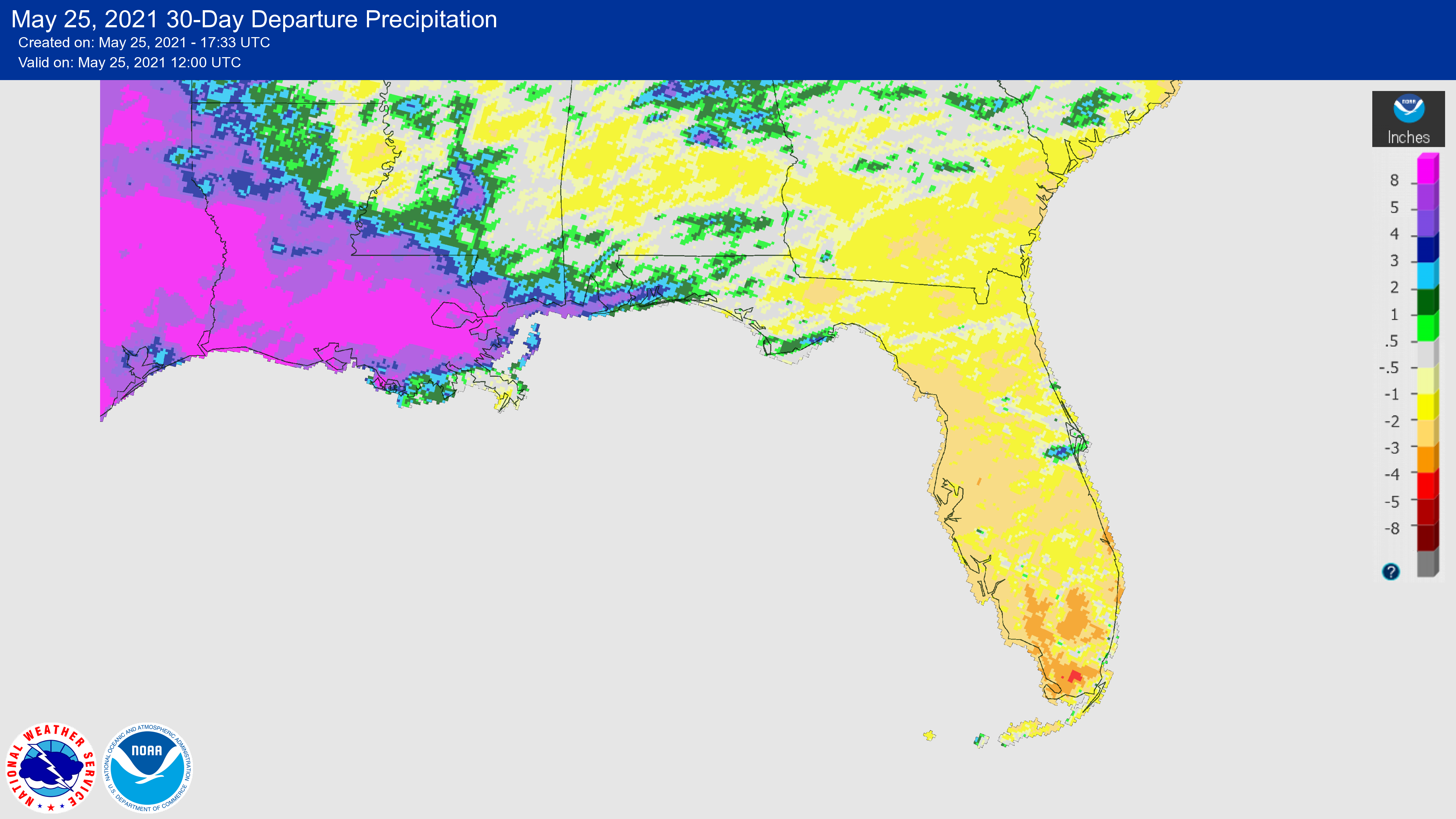
The figures below are graphical depictions of the monthly rainfall departure from normal (in inches) for February, March, April, and a 30-day departure as of May 25 (courtesy of the National Weather Service). Rainfall was below normal in southern Florida throughout the spring, which led to the persistence of abnormally dry conditions and the development of moderate drought in Southwest Florida.
|
|
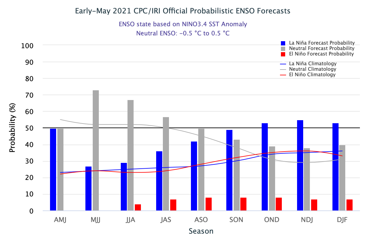
Update on the Latest ENSO Conditions and Forecast
The La Niña Advisory remained in effect through April; however, the advisory officially ended in early May with a shift to ENSO-neutral conditions. Neutral conditions are expected to persist through at least the Northern Hemisphere summer, with more uncertainty in the models moving into the fall and winter months according to the latest CPC/IRI (International Research Institute for Climate and Society) forecast (below).
|
|
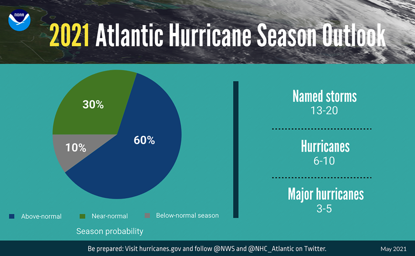
Above Normal 2021 Hurricane Season Expected |
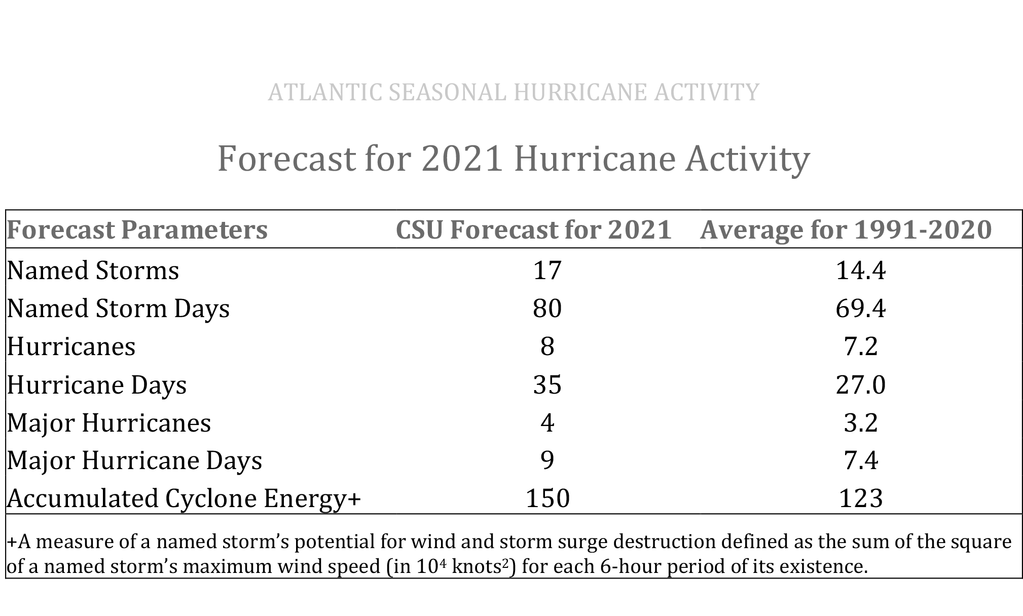
Official predictions have been released for this year's Atlantic hurricane season, which officially begins June 1st. While it is predicted to be another above-average season, it is not anticipated to be at the historic level of storm activity seen in 2020. NOAA's hurricane season outlook calls for 13-20 named storms, with 6-10 of those being hurricanes and 3-5 predicted to become major hurricanes (first graphic below). In addition, Colorado State University (CSU) released its official forecast for the Atlantic hurricane season last month (second graphic below). Their forecast is in line with NOAA's outlook and calls for 17 named storms, 8 hurricanes and 4 major hurricanes. The full CSU report is available HERE. An above-average season is expected due largely to anticipated ENSO-neutral or weak La Niña conditions and anomalously warm SSTs in the tropical Atlantic during the Atlantic hurricane season peak (August–October).
|
|
New 1991-2020 Climate Normals Now Available: Florida Became Warmer and Wetter |
|
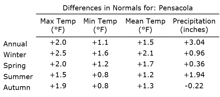
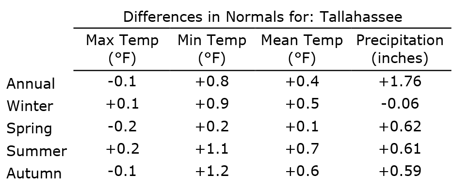
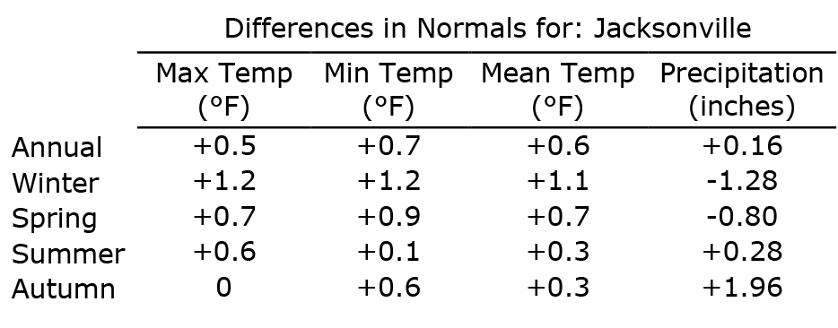
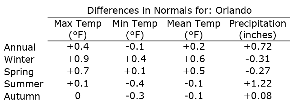
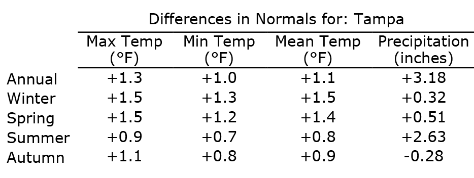
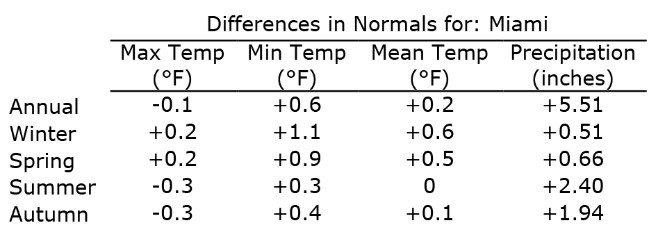
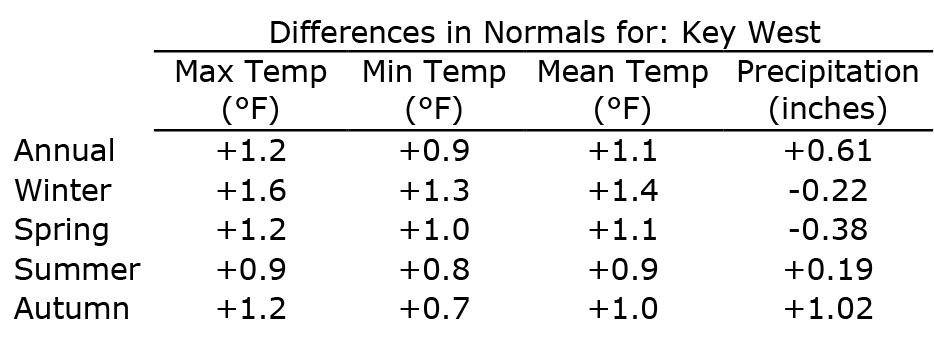
In early May, NOAA released the new U.S. Climate Normals data. Most of the U.S. was warmer, and the eastern two-thirds of the contiguous U.S. was wetter from 1991–2020 as compared to the previous normals period, 1981–2010. Maximum and minimum temperatures in Florida were warmer overall, and Florida was about 5% wetter annually compared to the previous 30-year average. For more information and to access the data, visit the NCEI Normals Data Access Tool. Additional resources and data tools are available on the SERCC website and from the NWS for select locations in West Central and Southwest Florida.
The following tables show the annual and seasonal differences between the new (1991-2020) and old (1981-2010) normals for maximum, minimum, and mean temperatures and precipitation for select major cities in Florida. The new Climate Normals data for these and other Florida cities can now be accessed on the FCC website HERE.
|
|
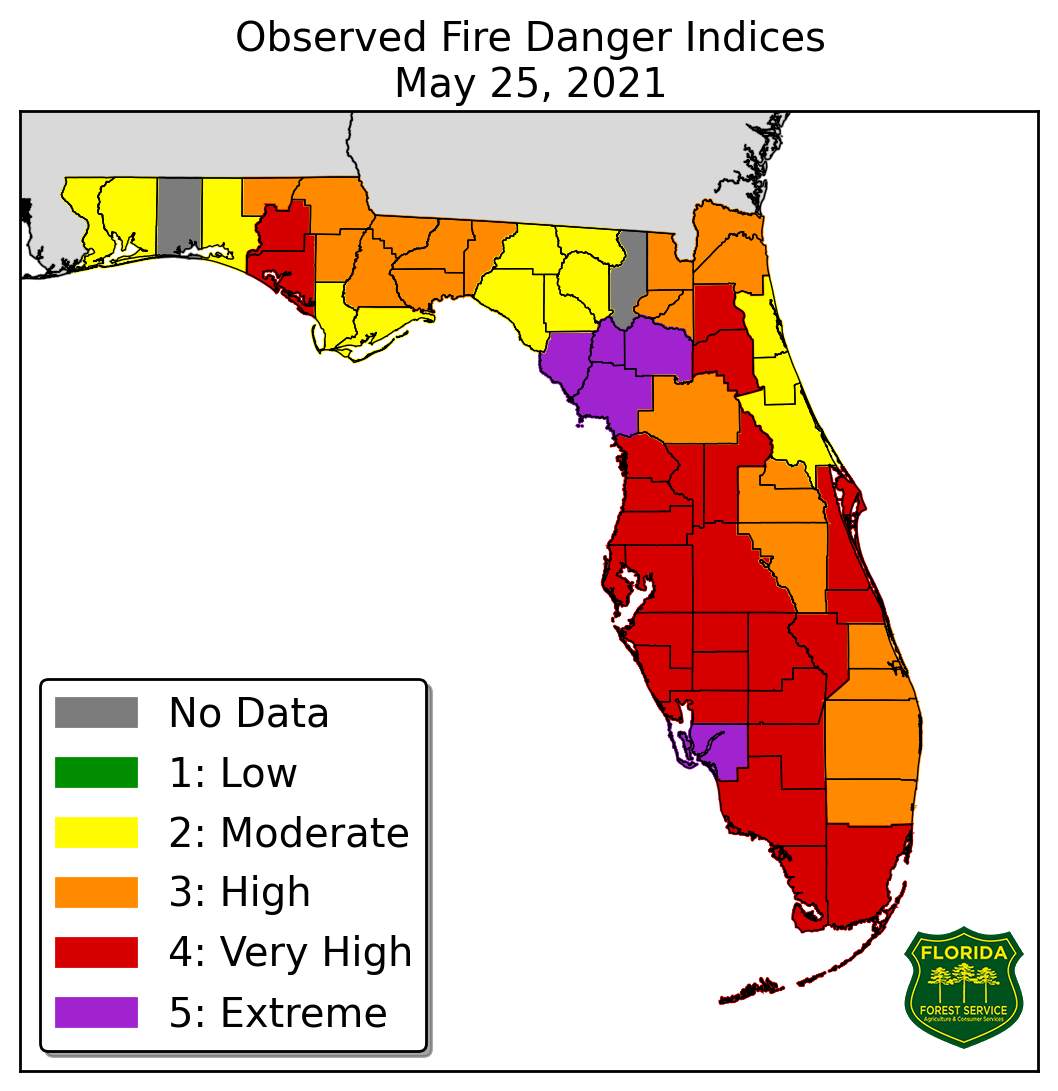
Wildfire Risks Increasing As Dry Weather Persists |
Persistent dry weather and above-average temperatures over the past few weeks have increased wildfire risk across the state. The Fire Danger Index (below) shows counties with current high wildfire risk, particularly over West Central and South Florida. The Florida Forest Service uses the Wildland Fire Danger Index (FDI) for estimating the potential for a fire to start and require suppression action on any given day. As of May 25, there were 61 active wildfires across the state with most of those contained, according to the Florida Forest Service. The Indian River County fire, known as the Tree Frog Fire, has burned roughly 800 acres and shut down I-95 for part of a day. The Florida Forest Service crews are actively working to contain these fires. So far this year, approximately 32,800 acres of state lands and 20,070 acres of federal lands have burned. |
|
Florida Climate Center in the News |
|
Southeast Climate Monthly Webinar Series
This webinar series, hosted by the Southeast Regional Climate Center in partnership with the National Integrated Drought Information System (NIDIS) and the NOAA National Weather Service, are held on the 2nd Tuesday of each month at 10am ET. Upcoming webinars will feature special topics on the 2021 hurricane season outlook and extreme heat. Register here.
|
|
Apalachicola-Chattahoochee-Flint (ACF) Drought and Water Monthly Webinars
These monthly webinars are held on the 4th Tuesday of each month at 1pm ET to provide updated information on the climate, water, and drought status of the Apalachicola-Chattahoochee-Flint River Basin. These webinars are sponsored by the Auburn University Water Resources Center and the National Integrated Drought Information System (NIDIS). Register here.
|
|
American Association of State Climatologists 2021 Annual Meeting - Virtual, June 4, 11, 18, and 25.
|
|
The Florida Climate Center is part of a three-tiered system of national, regional, and state climate offices, including NOAA's National Centers for Environmental Information (NCEI - in Asheville, North Carolina) and the Southeast Regional Climate Center (in Chapel Hill, North Carolina). The Florida State Climatologist and staff at the Florida Climate Center provide the following information and services to the people of Florida:
Climate Data
Historical weather observations for weather stations throughout the state of Florida. We are able to provide data for most stations from 1948-present.
Climate Information
Long-term historical averages for various stations, climate divisions, and the entire state.
Extreme Event Records
Information and analyses on extreme events such as freezes, droughts, floods and hurricanes.
Special Analysis
With their vast knowledge of El Niño, La Niña and climate variability, the State Climatologist and staff can offer expert insight into Florida's climate trends.
Outreach
Activities, presentations, and workshops that inform and educate the people of Florida about current and emerging climate issues. We also coordinate volunteers for the Community Collaborative Rain, Hail & Snow Network (CoCoRaHS).
|
|
Florida Climate Center | Florida State University | [email protected] | (850) 644-3417
|
|
|
|
|
|
|