Dear Florida Climate Center Friends, |
We'd like to present you with the Spring 2023 edition of our quarterly newsletter. In this newsletter, you'll find our most recent monthly climate summaries for the past three months, an update on the developing El Niño, the current drought status, and the upcoming seasonal outlook. You will also find an update on recent events and activities we've been engaged in. If you have any questions, please send us an e-mail at [email protected].
Thanks,
The Staff of the Florida Climate Center
|
|
|
Monthly Climate Summaries for Florida |
The Florida Climate Center's March, April, and May Climate Summaries for Florida are available, as well as previous monthly summaries. These summaries provide an analysis of temperature and precipitation patterns across the state, along with data on hazardous weather, drought, and daily records tied or broken each month.
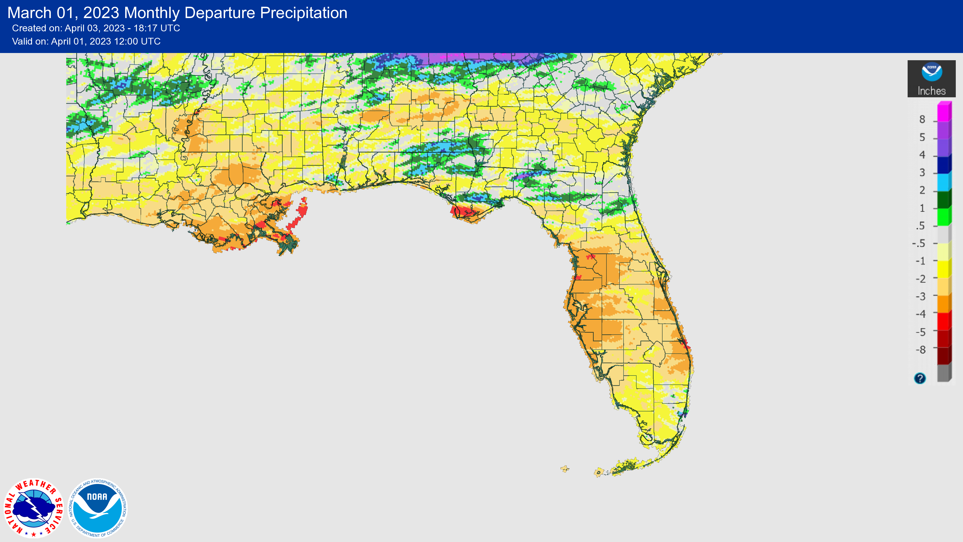
The monthly average temperatures in March were well above normal across the state. The monthly departures from normal ranged from +3.0 ̊F in Jacksonville to +5.0 ̊F in Tallahassee and Fort Myers. Record warm temperatures were recorded throughout the state during the first week of March. A late season frost occurred on March 20 and 21, with minimum temperatures dipping down into the upper 20s in the Panhandle and low 30s in northern Florida, which impacted fruit in north Florida and southern Georgia. The anomalously warm weather over the past few months kept chill hour accumulations in these regions below normal as well.
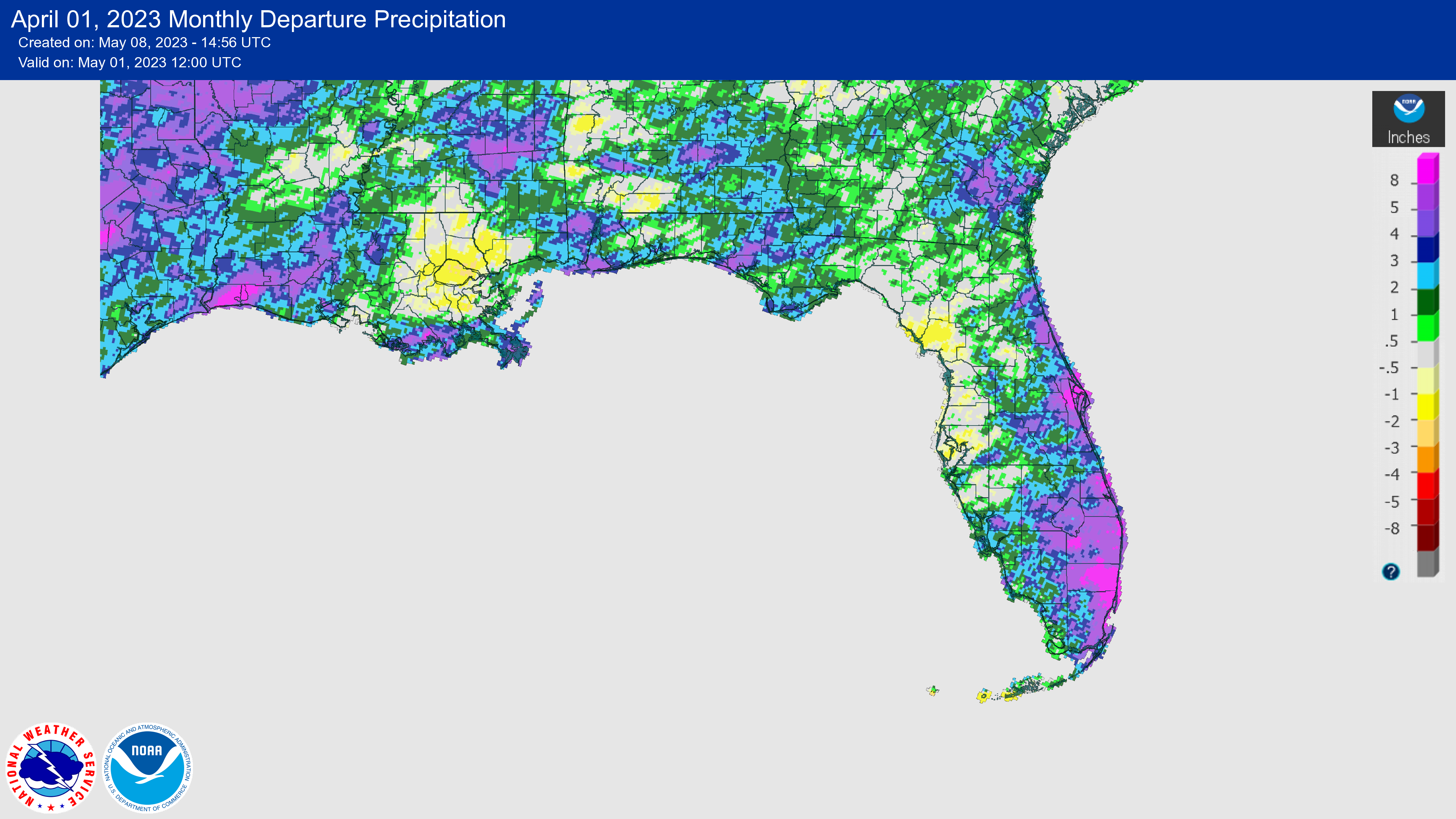
Average temperatures in April were above normal for the month across the state. Monthly mean temperature departures from normal ranged from +1.8 ̊F in Key West to +4.2 ̊F in Orlando. Sarasota and Lakeland recorded their warmest April on record, and many locations had one of their top 5 warmest Aprils on record, including Naples, Fort Myers, Tampa, Orlando, Daytona Beach, Miami and West Palm Beach.
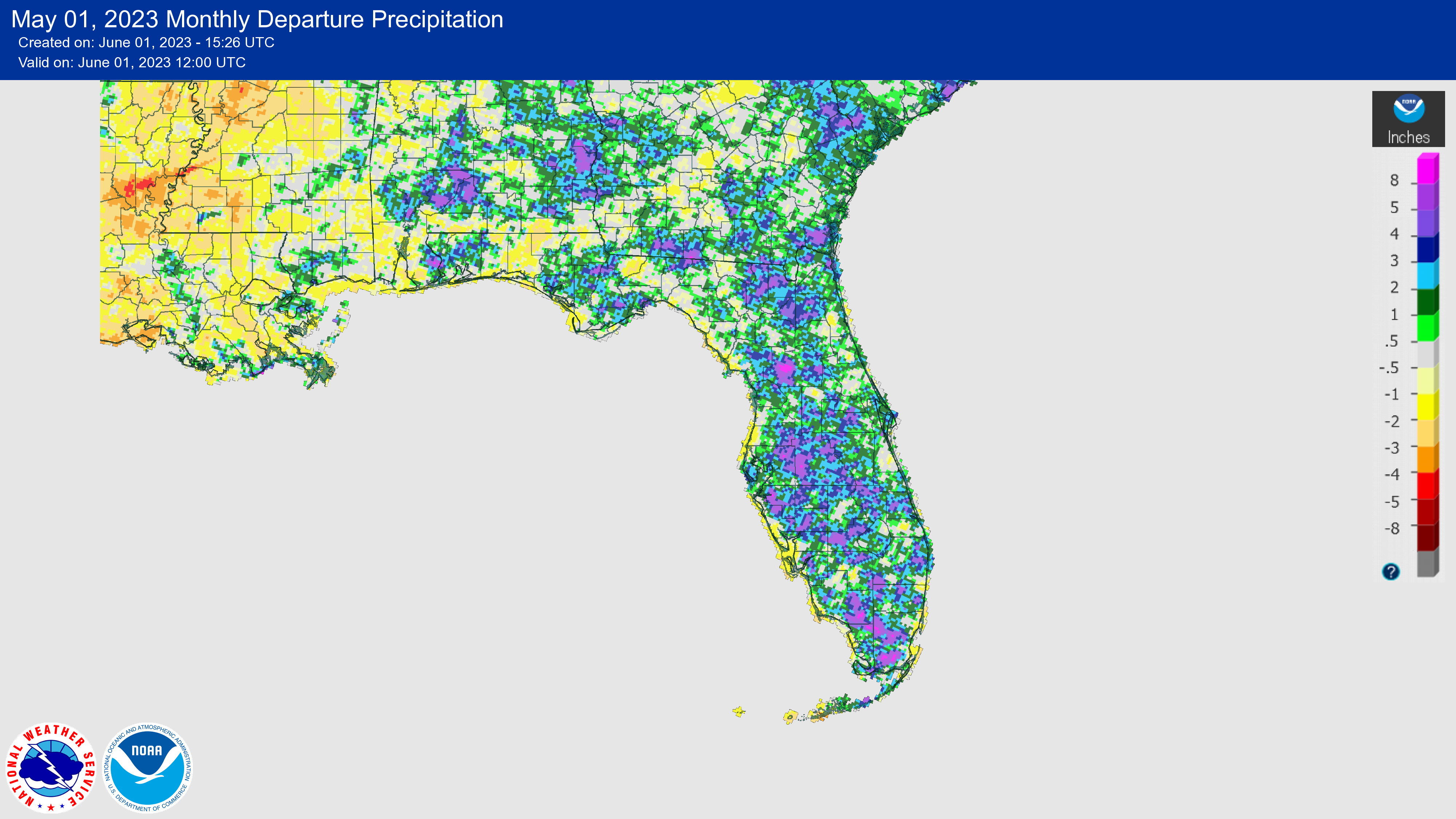
Average monthly temperatures in May were near to above normal. Monthly mean temperature departures from normal ranged from -1.1 ̊F in Melbourne to +2.0 ̊F in Fort Myers. While May was not as warm as previous month, these first five months of the year have been the warmest start to the year on record for many locations across the state, including Miami, Fort Myers, Key West, Sarasota, Tampa, Melbourne, Orlando, Daytona Beach, Ocala, Tallahassee, and Pensacola.
Florida has had a record warm start to the year so far. The year-to-date (January-May) statewide average temperature for Florida ranks as the warmest on record, at +5.2 ̊F above normal for the January-May period. Much of the eastern U.S. has experienced a similar trend of above-normal temperatures so far this year, with most eastern states ranking in the top 5 warmest for this 5-month period.
The figures below are graphical depictions of the monthly rainfall departure from normal (in inches) for March, April, and May (courtesy of the National Weather Service), as well as the 3-month seasonal rainfall departure from normal (courtesy of the Midwestern Regional Climate Center).
|
|
El Niño Has Arrived, Expected to Persist and Likely Strengthen
|
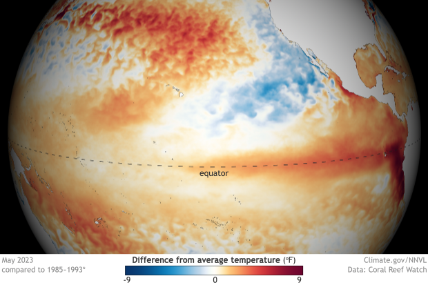
An El Niño Advisory has been issued by NOAA in its latest ENSO update released June 8th. El Niño conditions emerged in the equatorial Pacific Ocean in May and are expected to persist into the Northern Hemisphere 2023-24 winter. El Niño conditions in the equatorial Pacific Ocean are expected to strengthen in the coming months, with an 84% chance of a moderate event and a 56% chance of a strong event (November-January). Key oceanic and atmospheric indicators are now consistent with El Niño. All of the latest weekly Niño indices were more than +0.5°C, and the area-averaged subsurface temperature anomalies remained positive, reflecting widespread anomalous warmth. The stronger the event becomes, the more likely it is to produce typical El Niño weather patterns here in Florida in the coming months. |
|
2023 Atlantic Hurricane Season Expected to be 'Near Normal' |
On Thursday, May 25, NOAA's Climate Prediction Center released their 2023 Atlantic Basin Hurricane Season Outlook. The outlook is leaning toward a near-normal hurricane season this year, with conflicting indicators - El Niño, which is expected to continue to strengthen this summer and fall, versus very warm sea surface temperatures in the Atlantic. Overall, the outlook includes a 40% chance of a near-normal season and equal chances of an above-normal and below-normal season. The outlook calls for 12-17 named storms (70% likelihood) of which 5-9 could become hurricanes, including 1-4 major hurricanes (category 3, 4, or 5).
A surface area of low pressure in the Gulf developed into short-lived Tropical Storm Arlene on June 2, becoming the first named storm of the season. The system quickly weakened as it moved south and interacted with unfavorable conditions in the Gulf of Mexico.
This year, you will see a few changes to the National Hurricane Center forecasting products. The NHC is extending its tropical cyclone outlook graphics from 5 to 7 days to provide emergency managers and people more time to prepare for storms, while also maintaining the existing 2-day tropical weather outlooks. NOAA is also operationalizing a new hurricane forecast model this year and is utilizing an upgraded storm surge forecasting model.
Read the full announcement from NOAA here.
|
|
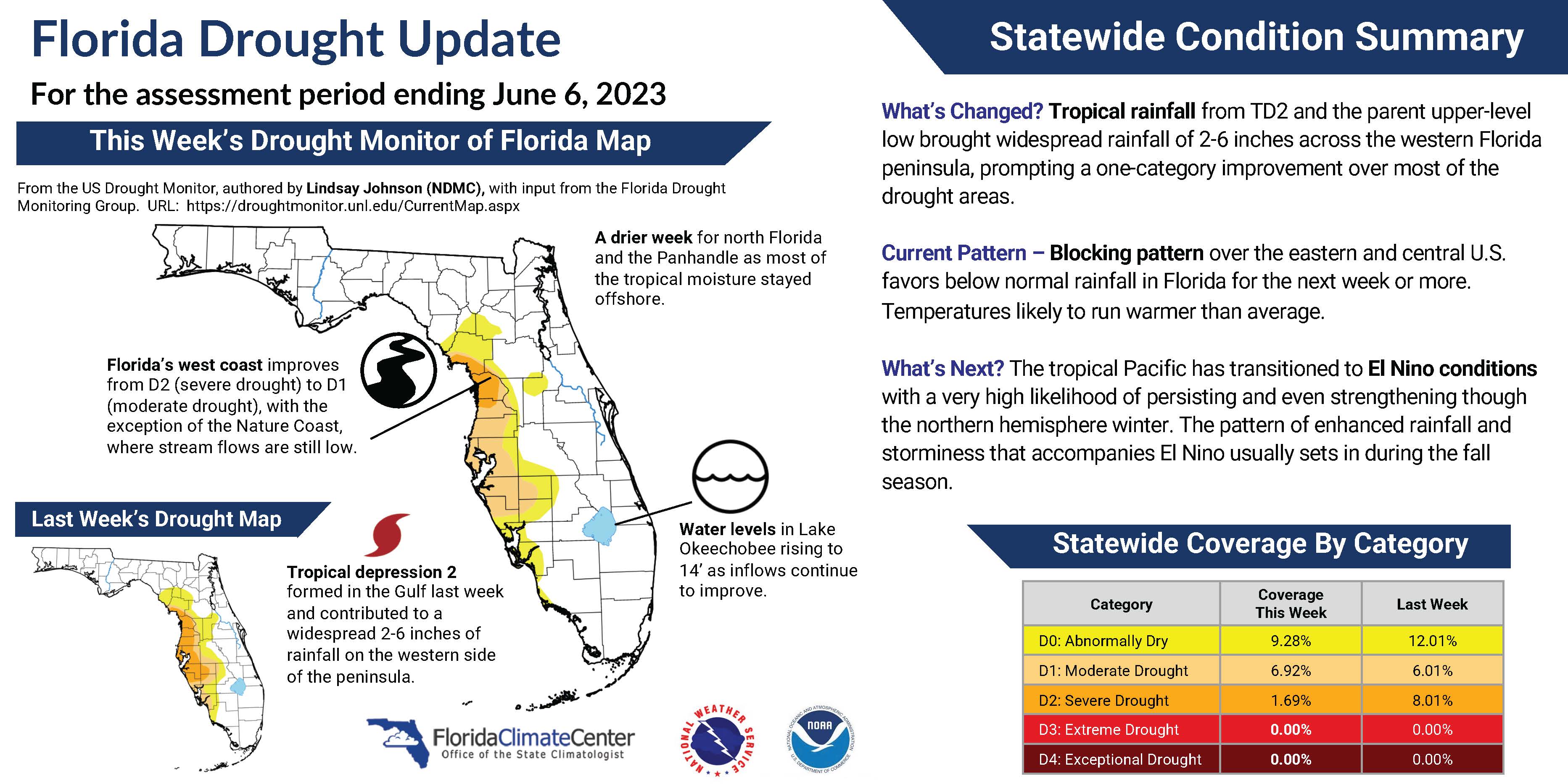
Latest Drought Update in Florida |
The Florida rainy season appears to be in full swing as drought conditions continued to improve across the Peninsula in May. Extreme drought (D3) was removed from the west Florida coast and most parts of the Peninsula saw a one-category improvement at the end of May and again in early June. Short-lived Tropical Storm Arlene contributed to widespread rainfall of roughly 2-6 inches as well over the past week.
Currently, 2% of the state is in severe drought (D2), 7% is in moderate drought (D1), and 9% is abnormally dry (D0); 82% of the state is now drought free (compared to 36% at the beginning of May), according to the U.S. Drought Monitor. Check out our latest Florida drought update below. These updates are also available on our website here.
|
|
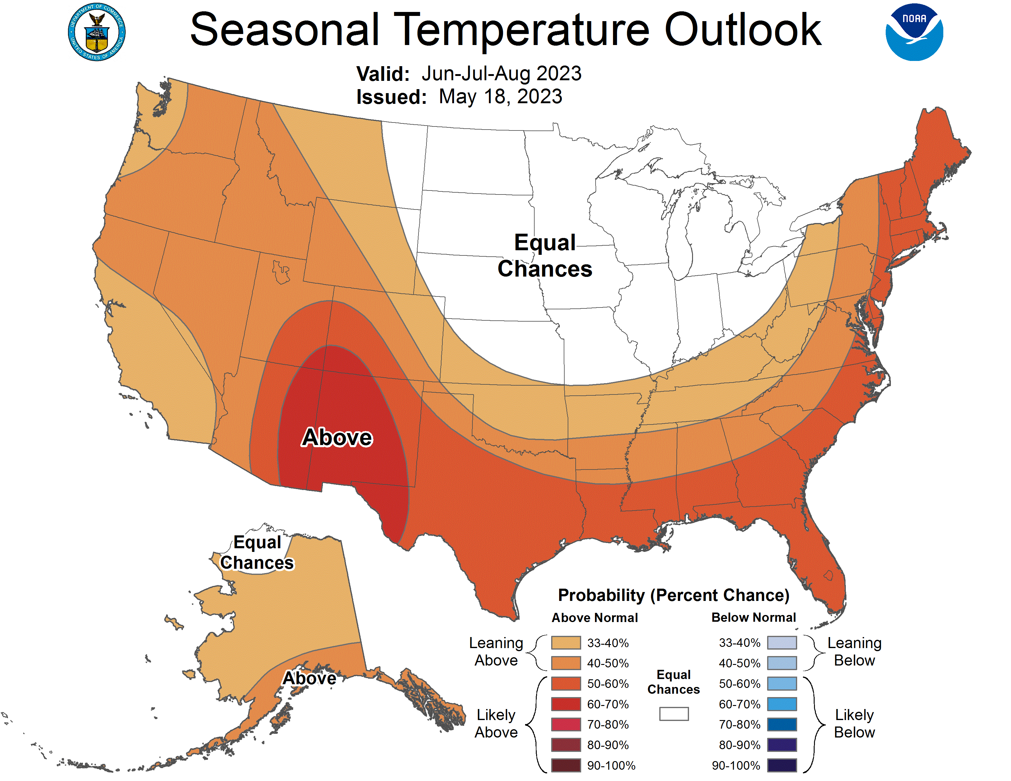
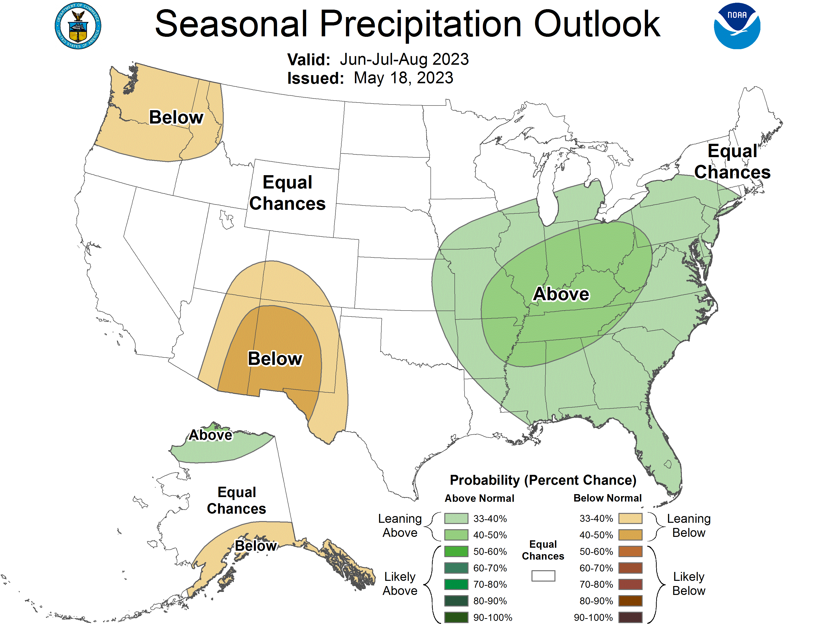
Seasonal Outlook for Summer 2023 Leaning Warmer and Wetter than Normal in Florida |
NOAA's Climate Prediction Center anticipates a warmer than normal summer on average, from June through August, for Florida and across the southern tier of the U.S. Average summer precipitation is leaning above normal for all parts of Florida, with a 33%-40% chance of above normal precipitation. Drought removal is expected over the Peninsula as the wet season progresses. |
|
State Climatologist Zierden Gives Keynote Presentation at the Southeast Coastal Center for Agricultural Health and Safety, Gainesville, FL, March 7, 2023
In an effort to support agriculturists who have been impacted by climate events, the Southeastern Coastal Center for Agricultural Health and Safety Center hosted its annual State of the Science event on March 6-7, 2023. The title of Zierden's talk was "Climate Trends and Variability - Applications to Agriculture in the Southeast." The focus of the 2023 State of the Science meeting was "The Impact of Climate Events on Agricultural Health and Safety."
View the full set of talks here.
|
|
State Climatologist Participated in a Panel on Climate Change at Jacksonville University, Jacksonville, FL, March 30, 2023
David Zierden was one of four panelists who participated in a discussion about Florida's climate challenges and actions to mitigate extreme events. Hosted by Jacksonville University, Zierden joined a panel of experts in climate science and resilience, including Anne Coglianese, the Chief Resiliency Officer for the City of Jacksonville, Esther Mullens, Assistant Professor of Geography at the University of Florida, and Lisa Rinaman, an environmental advocate serving as the St. Johns Riverkeeper. The panel was titled, "Florida's Future: Navigating Global Climate Change."
Read about the event and panel discussion here.
|
|
Southeast Climate Monthly Webinar Presentation - David Zierden gave a presentation for the Southeast Climate Monthly Webinar Series on the "La Nina Scorecard for the Southeast and what to expect this spring/early summer," on March 28, 2023. A recording of the webinar is available here.
|
|
Southeast Climate Monthly Webinar Series
This webinar series, hosted by the Southeast Regional Climate Center in partnership with the National Integrated Drought Information System (NIDIS) and the NOAA National Weather Service, is held on the 4th Tuesday of each month at 10am ET. The next webinar is June 27, 2023. The special topic will be on the 2023 Hurricane Season Outlook. Register here.
|
|
The Florida Climate Center is part of a three-tiered system of national, regional, and state climate offices, including NOAA's National Centers for Environmental Information (NCEI - in Asheville, North Carolina) and the Southeast Regional Climate Center (in Chapel Hill, North Carolina). The Florida State Climatologist and staff at the Florida Climate Center provide the following information and services to the people of Florida:
Climate Data
Historical weather observations for weather stations throughout the state of Florida. We are able to provide data for most stations from 1948-present.
Climate Information
Long-term historical averages for various stations, climate divisions, and the entire state.
Extreme Event Records
Information and analyses on extreme events such as freezes, droughts, floods and hurricanes.
Special Analysis
With their vast knowledge of El Niño, La Niña and climate variability, the State Climatologist and staff can offer expert insight into Florida's climate trends.
Outreach
Activities, presentations, and workshops that inform and educate the people of Florida about current and emerging climate issues. We also coordinate volunteers for the Community Collaborative Rain, Hail & Snow Network (CoCoRaHS).
|
|
Florida Climate Center | Florida State University | [email protected] | (850) 644-3417
|
|
|
|
|
|
|