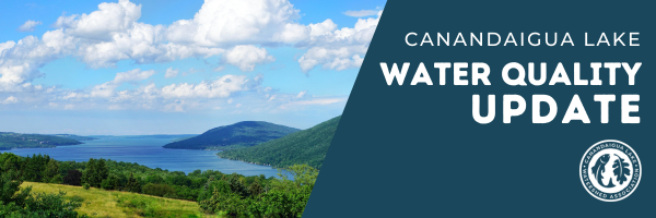
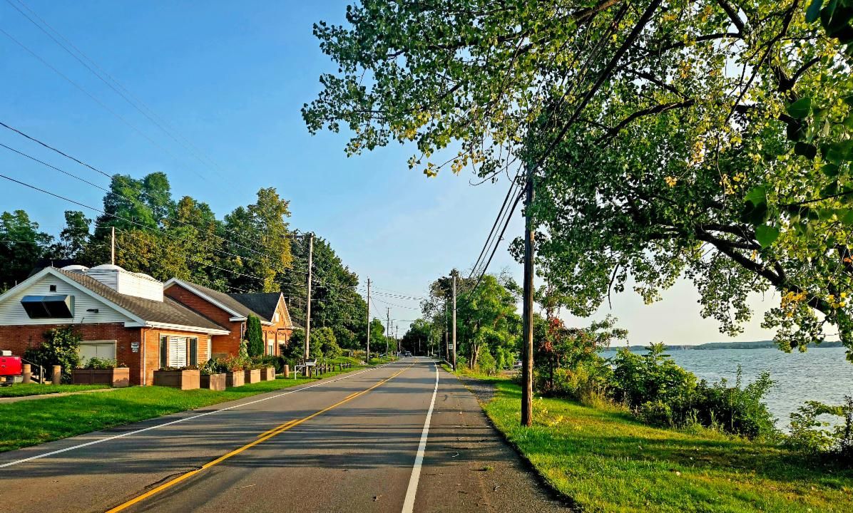
Water Quality Update for Friday, September 5th 2025 | | What a view in the watershed on the east side of the lake right now! | | |
The Lake This Week
We hope you had a lovely Labor Day Holiday at the beginning of the week. The mornings are getting cooler, the leaves are starting to change color, pumpkins and mums are popping up at the farm stands, and the kids are back in school - Fall is clearly on its way!
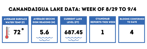
The lake's average water temperature stayed the same this week while the water level continued to go down. Average water clarity improved by about 3 ft this week which is nice to see. We had one small, localized bloom reported last weekend on the east side of the lake bringing our total number of reports for the season to four - but other than that it has been quiet. We had some more rain this week but the water level remains low - more about that below.
| |
You Are Our Eyes On The Lake
Seeing more plants than normal off your dock ? Or maybe even less? More zebra mussel shells washed up your shoreline than usual? We want to know!
Maybe you don't have the time to volunteer for one of our more formal volunteer monitoring programs like weekly HABs shoreline monitoring or weekly secchi disk and temperature measurements. That's OK. You are still our eyes and ears around the lake and that's also a very important job!
By keeping track of changes around the lake and year to year - we can gain valuable insight into what is happening with our lake. Its always helpful if you can take pictures to keep track of these things you notice as well. We might not have an answer right away - or even ever for that matter! But it all adds up to the bigger picture of lake health - and we just never know when one observation might lead to an 'aha moment'.
You may remember earlier this summer one of our volunteers casually mentioned the 'tapioca' on his fishing line. Well sure enough - after reaching out to local charter guides - this was apparently the worst year for invasive fishhook waterflea that anyone can remember. But then it was over fast. Boom then bust. Do we know exactly what this means or why it happened? No. But we are definitely making a note of it - because it could end up being a piece of the puzzle down the line. And we might not have even known about it if one of our members didn't mention something 'that wasn't normal'. If you are seeing something 'that isn't the way it normally is' - feel free to drop Emily a line anytime at edebolt@canandaigualakeassoc.org. Just remember - you'll get a reply - but not necessarily an answer!
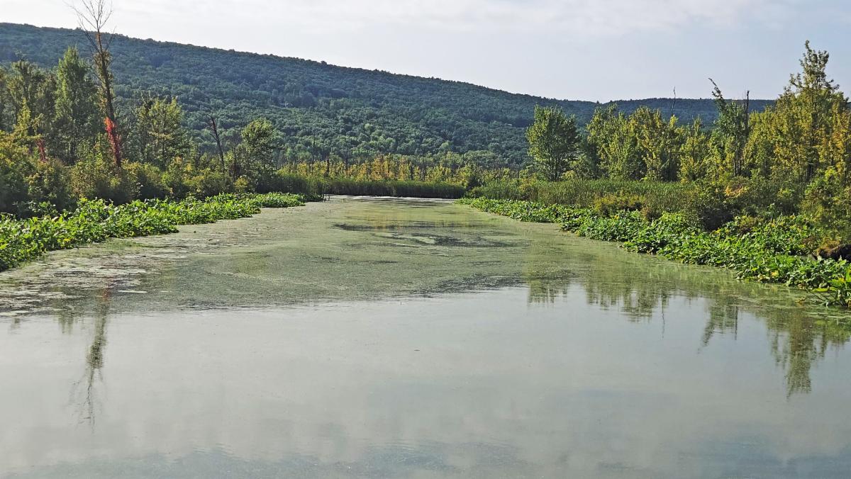
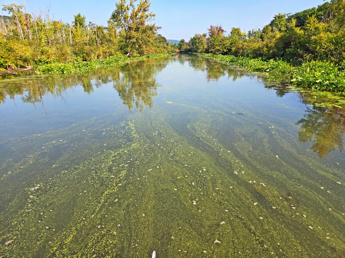
| | These two photos - above and below - are from the south end of the Lake this morning on the canal part of the West River. A volunteer reached out about this area and said that it sure looked like a large HAB on the canal - but that 'isn't normal' - so they weren't quite sure what to make of it. So - we went down to check it out - and sure enough as we approached - I thought we were driving into a giant slick of a HAB. | | |
But once we got there - we could see all the teeny tiny specs of watermeal sticking together - and sticking to the sides of the boat even. Not a HAB. Phew!
This definitely looked like 'spilled paint' even to me at first - which is one of the classic descriptions of a HAB. But one of the key ways to tell a HAB from a very similar look-a-like situation like this is is a super simple method we can call the 'Stick Test'.
Essentially - if it sticks to a stick - clumps together and you can pick it up - its most likely not a HAB (pollen, watermeal, some types of green algae - they all stick together). HABs don't stick - but rather if you stick the stick in and the spilled paint seems to disperse - almost avoiding the stick - and nothing sticks - then you probably have a HAB. Now the 'stick test' is of course more of a guideline than an official HAB ID method - but its a great way to help narrow it down if you aren't sure. And once again - why there is so much watermeal right now - that seems 'more than usual' - we aren't entirely sure. And that's ok. (Disclaimer: I should mention here that the guidelines - 'when in doubt - stay out' - are good to follow. We are not suggesting you drive into a large HAB to check it out. Toxins can become airborne. )
| | |
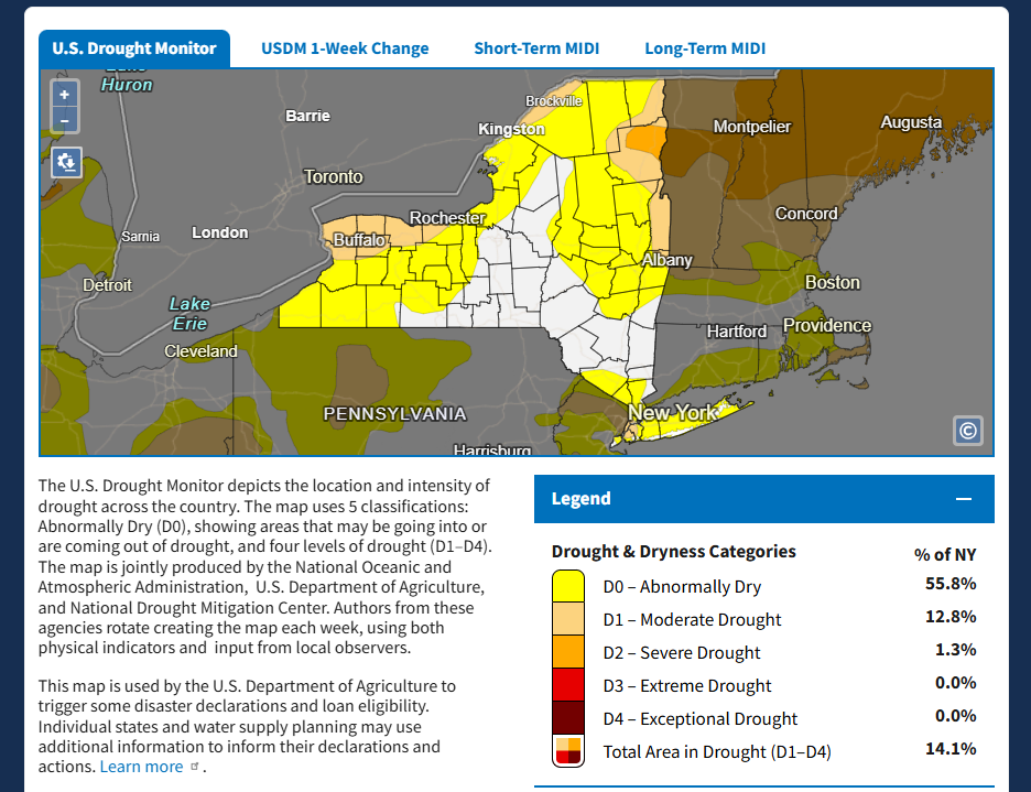
The lake level has been looking awfully low lately. Despite getting some rain at the end of August and then again yesterday even - it just hasn't been nearly enough to make a big impact. And we aren't the only lake with low water levels. In Lake Champlain - people can walk out to islands because the water levels are so low according to this article!
While New York State doesn't have our region included in the current 'Drought Conditions' - you can see from this NOAA site - that we are still considered 'Abnormally Dry' right now.
But isn't our Lake's level managed you might be thinking? Why can't we do something about the level? We asked CLWC Watershed Manager Kevin Olvany to shed some light into how our lake level works.
| | Drought.gov website showing how dry we are in NY right now. | | |
Why is the Lake so Low Right Now?
by Kevin Olvany, Watershed Program Manager, CLWC
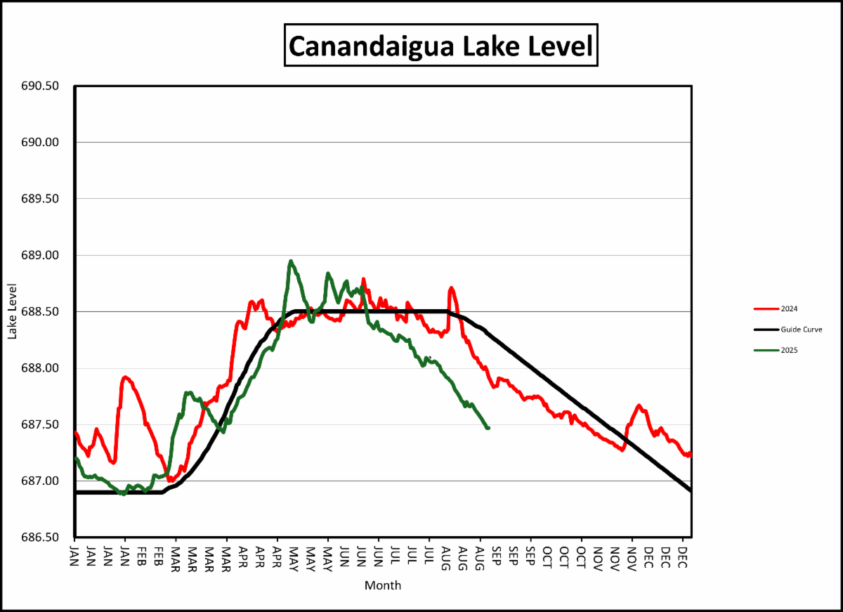
The lake level as of Thursday morning is 687.45 feet above sea level, or about 1 foot below the typical summer average of 688.50. When looking at the month of August alone, we lost about 7 inches of lake level! There are a lot of factors that impact the elevation or height of the lake, especially during the summer months. The factors can be broken down into Inflows into the lake and Outflows from the lake.
| | |
Lake Level Map provided by Michelle Hess, the Chief Operator at the Canandaigua Water Resource Recovery Facility.
| |
Inflows include rain falling directly on the lake and stream flow from the 350+ miles of streams that drain into the lake from the 109,000-acre watershed.
Since mid-June, and especially for the month of August, we have had very little rainfall in the watershed. This is especially true in the southern half of the watershed. The rain that we have received has largely been absorbed by the ground and is not ending up as stream flow to the lake. This has been great for reducing nutrients and other pollutants from getting into the lake, but not good for the lake level!
In August the Bristol Harbor rain gage totaled 1.3 inches and the Canandaigua gages were a little over 2 inches. Typically, we get around 4 inches of rain in August. Therefore, with little to no stream flow, the only real inflow into the lake was about 1.6 inches (0.2 feet) of rain that fell directly on the lake.
| | |
Outflows include evaporation, stream flow, and water supply withdrawal.
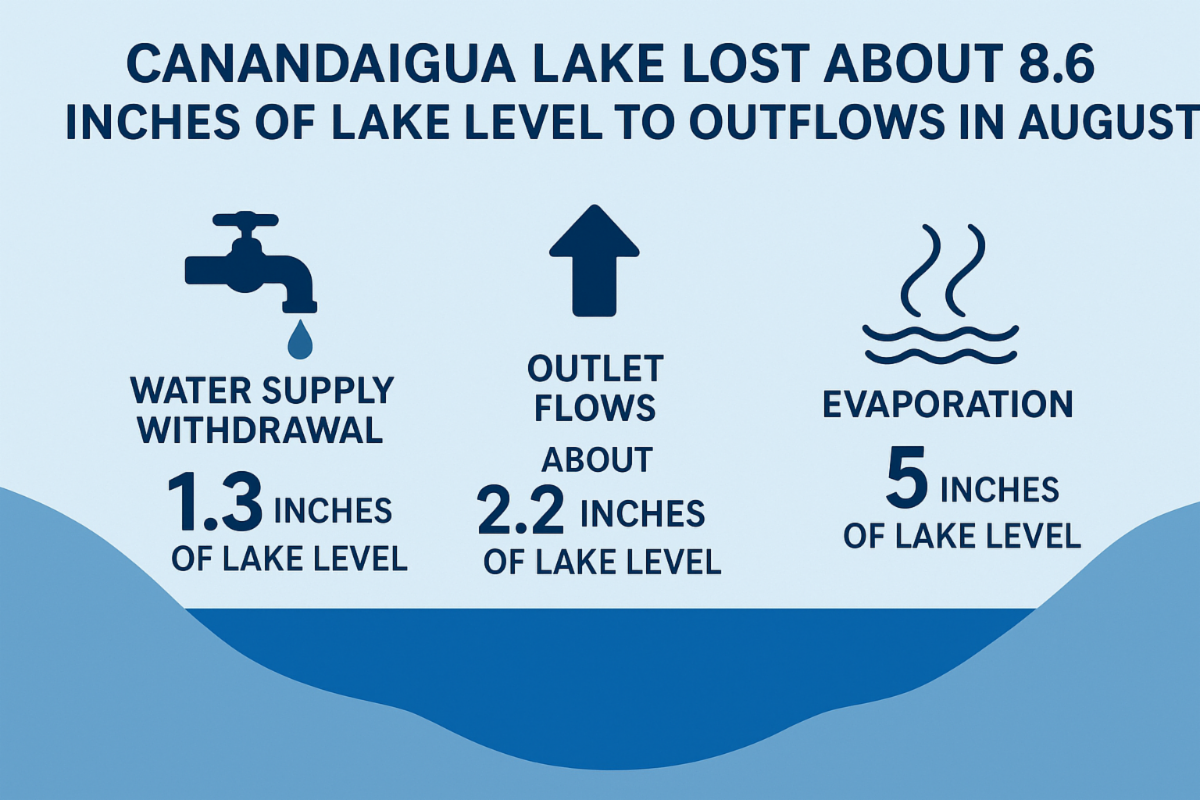
We received an average of 1.6 inches of rain on the lake yet we lost 7 inches of lake level in August - therefore we actually lost the equivalent of about 8.6 inches of lake level to outflows. There is about 300 million gallons in 1 inch of lake level.
The main outflows in order of importance are evaporation, outlet flows (main gate and feeder canal flow), and water supply withdrawal. I will start with the smallest outflow first: water supply. The 5 water purveyors use about 13 million gallons a day on average during the summer peak use season. Over a 30-day period that is about 390 million gallons of water, or about 1.3 inches of lake level, for the month.
The lake has two outlets: the main outlet behind Wegmans in Lagoon Park, and the feeder canal (near Scoops Ice Cream). The main outlet gates behind Wegmans have been closed since mid-June. The feeder canal is an outlet from the lake that goes north and connects into the main outlet. NYS DEC mandates that the City release about 22 million gallons per day through the feeder canal in order to properly accept the treated wastewater discharge from the City of Canandaigua, the VA, and Manchester/Shortsville wastewater treatment plants. Over 30 days that is about 2.2 inches of lake level.
The remaining outflow is evaporation from the lake and it is the biggest factor by far. We lost approximately 5 inches of lake level to evaporation over the last 30 days! This corresponds with modeled data on lake evaporation rates.
With the total watershed area being roughly 10 times the size of the lake’s surface area, rainfall in the watershed is a critical factor to maintaining lake level. During times of drought or higher than average rainfall events - Mother Nature is ultimately in charge of the lake level.
| | |
Is the Water Safe to Drink? | | |
So far this year we have only recorded 4 very small blooms to date. So small in fact - that our CLWA sampling volunteers haven't collected any samples to send for toxin analysis at the Finger Lakes Institute.
We haven't gotten the question - 'Is the water safe to drink?' as much this year as in years past - but we still want to be sure to make sure everyone knows that water testing is still being done routinely to ensure the safety of the municipal drinking water supplies around the lake. Kevin Olvany, the Watershed Program Manager from the Watershed Council (CLWC), has provided us with an update about this testing and how it works below.
| The City of Canandaigua Water Treatment Plant is located on West Lake Road in the Town of Canandaigua where it withdraws water from Canandaigua Lake. The Water Plant treats an average of 4 million gallons of water a day and supplies water to approximately 35,000 people. | | |
Water Purveyor Sampling Program Update
by Kevin Olvany, Watershed Program Manager, CLWC
There are 5 municipal water purveyors (City of Canandaigua, Gorham, Rushville, Palmyra, and Newark) that draw water from Canandaigua Lake, treat the water, and provide drinking water to approximately 70,000 people throughout multiple communities.
These communities have a long-standing sampling program to verify the safety of the water supply. One of the components that the water purveyors have been sampling for in recent years is the toxin that can be produced by cyanobacteria (blue green algae/harmful algae blooms). The purveyors collect samples of the raw water (untreated lake water that is pumped from the lake and into the treatment plants) on a weekly basis and are transported to the Erie County Department of Health, a NYS certified lab and analyzed for the microcystin toxin.
This year, sampling began in early August and will continue through September and potentially into October. So far, all results have been non-detectable for the toxin in the raw water. If the purveyors start to see the toxin in raw water, they will start testing the fully treated water. The 5 purveyors have a long track record of showing that their treatment plants have successfully removed the toxin from the drinking water over multiple years. This is good news and helps us maintain confidence in our high-quality water supply!
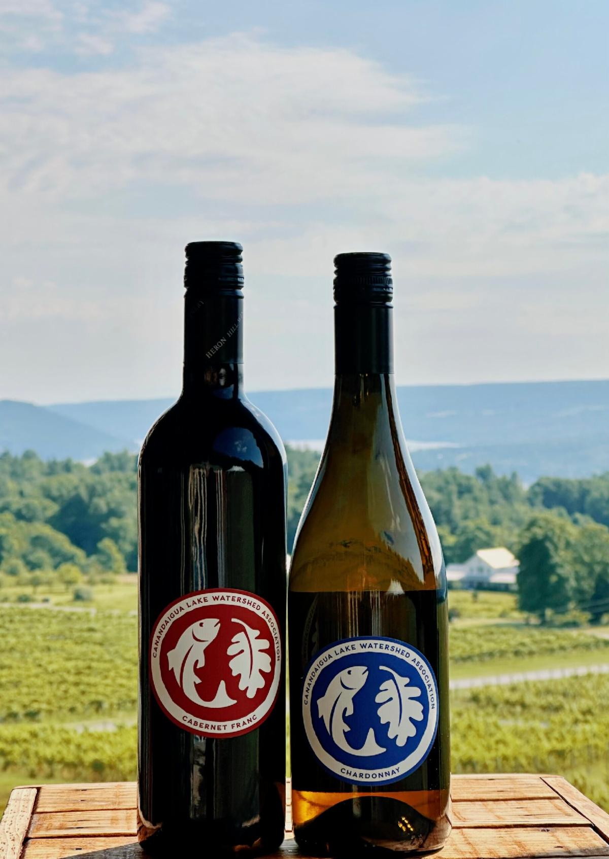
| | Heron Hill and CLWA Collaboration Tasting Event | | |
When: Wednesday, September 24th, 5:30-7:00 PM
Where: Heron Hill Tasting Room at Canandaigua Lake, 5323 Seneca Point Rd, Canandaigua, NY 14424
Start the night with a welcome pour that Heron Hill has graciously chosen to use for the CLWA collaboration. Continue the night with a glass of wine available for purchase. Also enjoy beer, cider, and NA options that will be available at the bar hosted by Heron Hill.
| | | | |
During this event you will also enjoy:
- A short welcome presentation by Heron Hill and CLWA
- Live music by the duo High Strung
- A tour of the gorgeous Cabernet Franc vineyard
- Delicious treats donated by Julie Woloson
- Light snacks to enjoy with your drinks
- The opportunity to speak with Heron Hill's amazing staff and wine makers
- The opportunity to learn more about how you can get involved and help in lake protection efforts
| | |
Chardonnay:
A bright golden straw colored wine with powerful aromatics of lemongrass and green apple skins balanced with minerality. The palate is bracing, but balances with medium to full body.
Cabernet Franc:
Rich and exciting with plum, blackberry, mint, and clove aromatics. On the palate the wine shows tremendous strength with ripe tannins, seamless acidity and wonderful fruit and herbal tones leading to a long finish. This is a wine that will do well over the next 8-12 years in the cellar as well.
WHERE DO THE GRAPES COME FROM?
Ingle Vineyard, situated on the west side of Canandaigua Lake, is the largest vinifera vineyard on the lake. Owned and maintained by the Ingle family for over 50 years, the vineyard is rooted in sustainability, free of herbicides and pesticides, and for using environmentally responsible practices. All grapes are hand-harvested to ensure only the finest fruit is selected.
$24 Per Case is donate back to CLWA. Preserve the Lake, One Bottle at a Time!
| | | | |
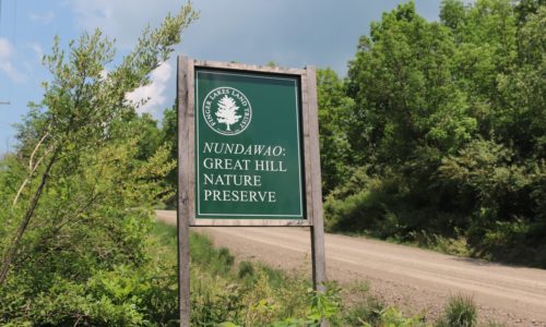
Trail Work Day with the Finger Lakes Land Trust (FLLT)
Join the Canandaigua Lake Watershed Association and the Finger Lakes Land Trust (FLLT) for a trail work day at the Great Hill Nature Preserve in Middlesex NY.
| | | |
When: Friday, September 26th, 10:00AM-12:30PM and 1:30-4:00PM
Where: Great Hill Preserve, 4756 S Hill Rd, Middlesex, NY 14507
*Meet location will be Clark’s Gully parking area because parking is a bit tricky at the preserve. We will then carpool to the preserve.*
Please wear appropriate attire for trail work and bring plenty of water and a snack if you’d like. We will take a lunch break mid-day. You can plan to join us for the morning, the afternoon - or both!
*Registration is required so we know how many volunteers to expect. Register at the link below. Thank you!*
| | Chipotle Fundraiser to Benefit CLWA - Mark Your Calendars! | | New York State Federation of Lakes Association (NYSFOLA) Western Region Conference | |
When: Saturday, October 25th, 9:30 AM - 2:30 PM
Where: The Woods, 6021 State Route 21, Naples, NY 14512
Join NYSFOLA for its 32nd Annual Western Regional Conference at this gorgeous location with breathtaking views of the Lake. During this conference, you will have the opportunity to learn from water quality experts on current lake and watershed issues facing our region, and have the chance to connect with fellow lake lovers involved in surrounding lake associations.
You will find further conference details, including the cost and agenda at the registration link below. We hope you can join us for this fabulous event.
Photo by The Woods
| | |
Stay informed so you can enjoy Canandaigua - or other New York Lakes - safely and confidently this summer.
We have a map on our website homepage for Canandaigua Lake reported blooms.
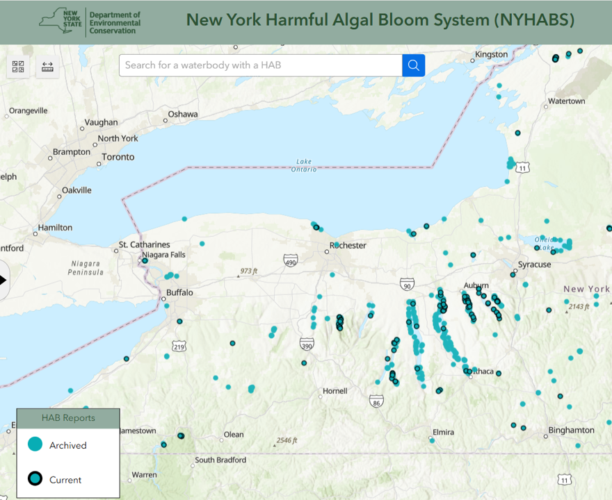
NYHABS Map
The link below leads to the NYHABS interactive map and displays the location of HABs in New York State. Each blue dot outlined in black represents a HAB reported in the past 2 weeks. There may be other waterbodies with HABs that have not been reported to DEC. All reports through our monitoring program are shown on our own map on our website. CLWA staff uploads all HABs report to the NYHABs database that we receive through our trained volunteers. You can also upload a HABS report directly to DEC here.
Visit NYHABS map here NYHABs map on Sept 5 shown below.
| | |
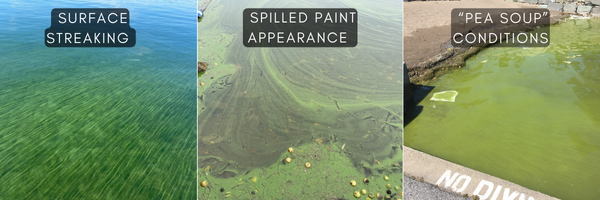
Remember - conditions can change rapidly. Please use caution when out on the lake and look for characteristics of HABs including water that looks like:
- Pea soup, spilled paint, surface streaks or scum
- Color's that are typically green, blue-green or yellow but can also be brown, red or purple
- Typically found along shorelines or coves
For images and more information on HABs, refer to the section below.
Please, to keep yourselves and pets safe, avoid any water conditions that appear to be bloom-like. Don't hesitate to reach out to us at 585-394-5030 with any questions or email us at HABS@canandaigualakeassoc.org if you are concerned about water quality. Sending us photos of the water is strongly encouraged. Have a wonderful weekend and stay tuned.
| | |
About HABs
Cyanobacteria, sometimes referred to as blue-green algae because of their color, are among the oldest organisms on Earth. They are naturally occurring in our lakes, generally in low numbers.
When triggered by the perfect storm of conditions - such as heavy rains followed by a few days of warm weather with calm winds - cyanobacteria may begin to increase, forming “blooms”. HABs can appear quickly and persist for hours or days, or they can disappear almost as quickly as they formed.
Since previous research informs us that high levels of toxins (microcystin) may accompany the blooms, humans and our pets should avoid coming into contact with the water when an active bloom is observed.
How to identify blooms
Use visual cues to identify potential blooms. They can appear like pea soup, spilled paint, surface streaks or scum. The color is typically green, blue-green, or yellow, but can also be brown, red, or purple. When blooms are discovered, they are usually found along shorelines or in cove areas. They are most often seen along the stretch of shoreline that is impacted by the prevailing winds. However, during significant bloom events, sometimes they can be found in open water areas.
Visit the NYS DEC website to learn more about identifying blooms.
| | |
What should you do if you suspect a bloom
When in doubt, stay out!
- Don't swim, wade, jetski, waterski or tube in a bloom.
- Shower if exposed to bloom conditions. Wash pets off if they have gone into bloom-infested waters.
- Don't consume fish from the lake during blooms.
- Do not use PRIVATE water drawn from the lake during a bloom. Public water supplies have safeguards in place and can be utilized unless you are otherwise notified.
-
Report the bloom to the NYSDEC NYHABs portal: on.ny.gov/habform
| | | | |