Hurricane Milton
5:00 PM National Weather Service Advisory
| |
|
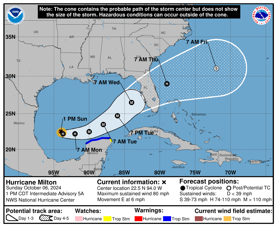
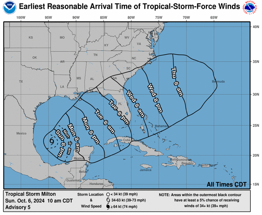
The City of Naples is closely monitoring Hurricane Milton, which strengthened from a tropical storm earlier this afternoon. Milton is expected to continue intensifying into a major storm, posing life-threatening risks to parts of Florida's west coast, including Naples, as early as late Tuesday evening.
As of the 5:00 PM National Weather Service advisory, Milton is about 805 miles WSW of Tampa, Florida, and approximately 800 miles southwest of Naples, Florida. The storm is moving east at 7 mph with maximum sustained winds of 85 mph.
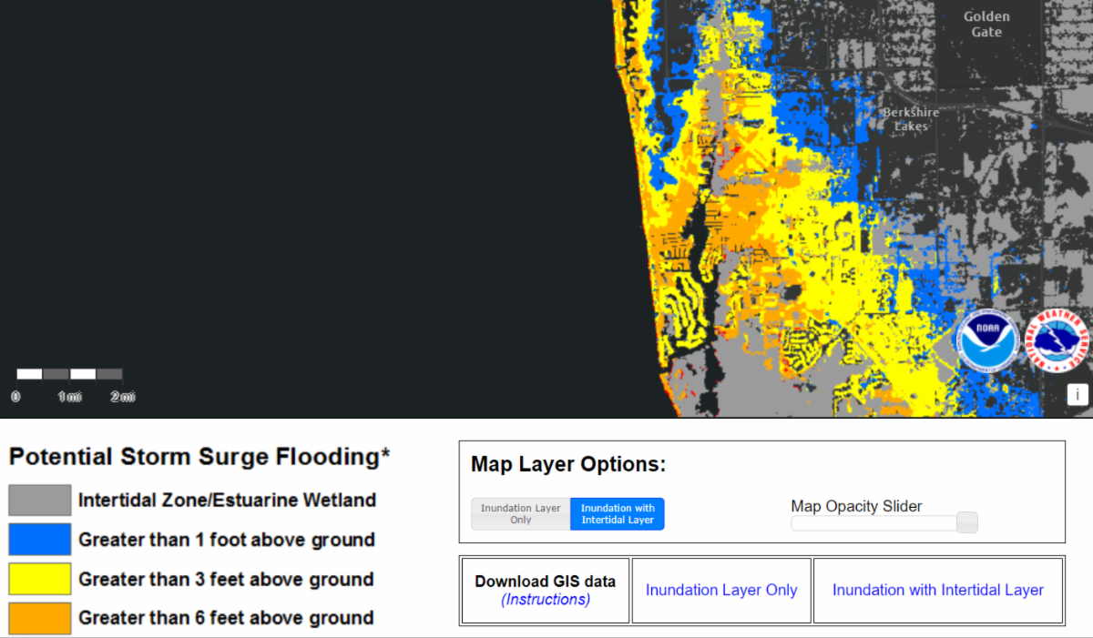
Governor Ron DeSantis has declared a State of Local Emergency for 51 counties in Florida, including Collier County. Mayor Teresa Heitmann will sign a proclamation declaring a Local State of Emergency tomorrow morning, October 7th. The City of Naples is coordinating closely with partner agencies to keep residents informed as the storm approaches. Based on current models, all residents and businesses are strongly urged to prepare for storm surge conditions similar to what was experienced during Hurricane Ian two years ago. Some areas of Naples may experience 6-9 feet of storm surge due to higher-than-normal tides.
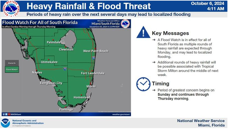
A flood watch is in effect for our area through October 10, 2024. Heavy rainfall this weekend, combined with elevated tides and an expected 12 inches of rainfall from Hurricane Milton by mid-week, presents a serious flood risk to our area. While Collier County has not yet announced shelter openings, residents in low-lying areas are urged to prepare their homes and move to higher ground before Tuesday. Take action now to ensure your safety. A voluntary evacuation for all low-lying areas that were affected by Hurricane Ian two years ago is now in effect. Most of the City of Naples is located in evacuation Zone A (see map below) and be ready in the event of a mandatory evacuation.
City Closures, Cancellations, and Notifications:
- The Planning Advisory Board meeting scheduled for Wednesday, October 9th has been canceled.
- Building Department inspections are canceled Monday through Wednesday. All construction sites must be secured and in compliance with pre-storm regulations.
- The City anticipates full closures of all beach ends, parks, and the Naples Pier ahead of the storm. A date and time will be announced tomorrow.
- Do not leave loose horticulture debris in your yard or place it in the City’s right-of-way. Secure all debris until after the storm has passed.
- The City of Naples is lowering all stormwater lakes to their lowest levels to maximize storage for the anticipated rainfall before and during the storm.
- Private properties with storm drains: please check and clear them of any debris.
- Private properties: please turn off all irrigation systems.
- The City's south parking garage remains CLOSED to the public. Please see the information below regarding parking electric vehicles.
-
NOTICE: Storing boats and trailers in the City's parking garage is prohibited. Violators will be towed at the owner's expense.
Please review the resources below for information on disaster supplies and evacuation routes.
Stay informed by regularly checking local news outlets, the National Hurricane Center, and the National Weather Service - Miami Office. Additional updates will be provided tomorrow.
Stay safe Naples!
| |
Potential Storm Surge Flooding for Naples, Florida
Click the image to enlarge
| |
Do you know your Flood Zone and when to evacuate?
Click the image for more information on Evacuation Zones
| | |
|
|
It is important to know the difference of the watches and warnings and the conditions that are anticipated:
-
Flood Watch is issued when conditions are favorable for flooding. It does not mean flooding will occur, but it is possible.
-
Flood Warning is issued when flooding is happening or will happen soon. Some roads will be flooded.
-
Storm Surge Watch means the possibility of life-threatening inundation from rising water moving inland from the shoreline somewhere within the specified area, generally within 48 hours, in association with an ongoing or potential tropical cyclones, a subtropical cyclone or a post-tropical cyclone.
-
Storm Surge Warning means there is a danger of life-threatening inundation, from rising water moving inland from the coastline, during the next 36 hours.
-
Tropical Storm Watch: An announcement that sustained winds of 34 to 63 knots (39 to 73 mph or 63 to 118 km/hr) are possible within the specified area within 48 hours in association with a tropical, subtropical, or post-tropical cyclone.
-
Tropical Storm Warning means that tropical storm conditions are expected somewhere within the warning area within the next 36 hours.
-
Hurricane Watch: An announcement that sustained winds of 64 knots (74 mph or 119 km/hr) or higher are possible within the specified area in association with a tropical, subtropical, or post-tropical cyclone.
-
Hurricane Warning: An announcement that sustained winds of 64 knots (74 mph or 119 km/hr) or higher are expected somewhere within the specified area in association with a tropical, subtropical, or post-tropical cyclone.
| |
-
Never walk or drive in the flood waters. Many people are killed by driving or walking on roads and bridges that are covered by water. Even though the water might look only inches deep, it could be much deeper and have strong currents. It takes only two feet of water to carry a car away, and only six inches of swiftly moving water to sweep a person off their feet.
-
Find an alternate route around the flooded area. If you are approaching a flooded roadway, turn around and take an alternate route, even though vehicles in front of you may have passed through the high water.
-
Don't assume your vehicle is safe. High water in streets and intersections will quickly stall motor vehicles. Most trucks, four-wheel drives, and sport utility vehicles are susceptible to being swept away by high water.
-
Never stay with your car in a flooded area. If your car stalls, abandon it immediately and climb to higher ground. Many deaths have resulted from individuals attempting to move stalled vehicles.
-
Safety First: Do not attempt to surf, water ride, or engage in similar activities on medians, easements, and roadways. This is extremely dangerous and may result in police enforcement actions.
| |
Collier County Sand & Sandbags Availability UPDATE
Beach Sand - Taking/Removal is PROHIBITED
| |
- North Collier Regional Park/Sun-N-Fun Lagoon is OUT of sand and will not receive any more today;
- 60 tons of sand is en route to Donna Fiala Eagle Lakes Community Park, and once it’s gone, that location will not receive any more today;
- Big Corkscrew Island Regional Park still has approximately 30 tons of sand available. It will not receive any more deliveries today once that is gone;
- Sandbag supplies are starting to run low at all locations. Should they have them, residents are encouraged to bring empty sandbags and shovels;
- 150 tons of sand is scheduled to be delivered, 50 tons per location, tomorrow (Monday) at 10 a.m.;
- Hurricane season is not over. Residents are encouraged to keep their sandbags stacked and out of the sun in case they are needed again this season.
- There are 51 counties under the Governor’s State of Emergency. All are in the market for sand! We appreciate your patience!
Sandbag Locations:
-
Big Corkscrew Island Regional Park, 810 39th Ave. NE, Naples, FL 34120, by the pickleball courts
-
North Collier Regional Park, 15000 Livingston Road, Naples, FL 34109, in the Sun-N-Fun Lagoon parking lot
-
Donna Fiala Eagle Lakes Community Park, 11565 Tamiami Trail East, Naples, FL 34113, in the grassy area between the parking lots
Sandbags, when properly filled and placed, may divert water around instead of through buildings. Sandbag construction does not guarantee a watertight seal but is satisfactory for use in most situations. Burlap sacks and plastic sandbags (polypropylene) are standard types to use. Garbage bags are not recommended since they are too slick to stack.
For additional information on sand and sandbag availability or sandbag assistance for those with special needs, please contact the Collier County Road, Bridge & Stormwater Maintenance Division at (239) 252-8924.
| |
Electric Vehicles (EV) & Golf Carts
Due to anticipated flooding in our area, residents should avoid parking any electric vehicles, including golf carts, in low-lying areas or parking garages (underground or above ground). EV's should not be stored in a structure where they will be or could be exposed to flood waters. If you are unable to park your vehicle in an area of high ground, then park it outside at least 50 feet away from any structures.
Per Florida DEP: Not all EV batteries will incur damage after flooding but it can happen, particularly with saltwater. Users should be aware that smoke or strange noises from the battery could be an indication of battery damage, but a battery also could be damaged without immediately showing those signs. NFPA Safety Bulletin on Submerged Hybrid Vehicles/EVs If an EV lithium battery is suspected to have been damaged by flooding, particularly an EV or hybrid vehicle battery, the owner should not attempt to charge or drive the vehicle. Residents should not go near any damaged electric vehicles. EV vehicles with damaged lithium batteries should not be stored indoors or near structures in case the battery does spark a fire or is venting hazardous gases. The vehicle should be towed and checked by the dealer or a mechanic certified for hybrids or EVs before the vehicle is used. The recommended distance between EV vehicles with damaged lithium batteries is 15 meters (50 feet). If an EV has sustained damage and cannot be towed, request assistance from emergency responders to safely disconnect the battery pack from the vehicle. dealer or a mechanic certified for hybrids or EVs before using it. The recommended distance between EV vehicles with damaged lithium batteries is 15 meters (50ft).
| |
Resources: Stay Informed and Be Prepared! | | | | |