|
Ag Weather Update
Matt Dixon, Meteorologist
UK Ag Weather Center
Updated 1-4-24 at 8:00 PM ET
| Drought expanding yet again | |
Good evening, everyone, and Happy New Year! Dry conditions are once again posing an issue, this time in the form of a hydrologic drought, resulting from four straight months of below normal rainfall. In December, the state only averaged 2.39 inches, over 2 inches below normal (maps below). While not official yet, this figure would place among the top 20 driest Decembers of all time! Diving deeper into the data, if you tally up the deficits over those four months, preliminary numbers suggests this would mark the sixth driest four-month stretch to end a year—a record spanning 129 years! | 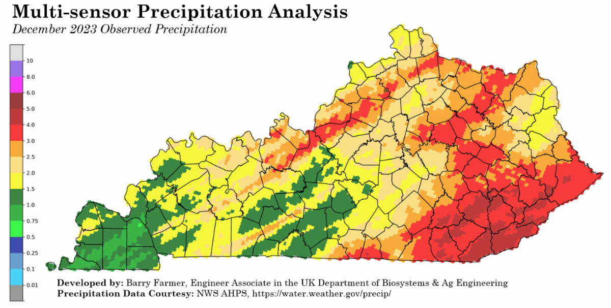 |  | |
The prolonged dry spell is giving rise to increasing hydrologic impacts, particularly affecting reservoirs. Two notable examples come from Berea and Stanford, KY (see pictures below), where water levels have significantly diminished. In response, the Mayor of Stanford has declared a State of Emergency, urging residents to reduce water usage by 20%.
Stream flows and farm ponds are displaying similar deficits. Looking at the map below, average stream flow conditions have been below or much below normal across the entire state over the past 28 days. During a webinar today, Chip Zimmer, an environmental scientist with the KY Division of Water, remarked that in his tenure since 2009, he has never observed streamflows this low with such widespread coverage across Kentucky.
|  |  | Summing up all the information, you arrive at the map below, which reflects the most recent update to the U.S. Drought Monitor. Approximately 83.5% of Kentucky is currently classified as experiencing a moderate or severe drought. This situation won't be resolved with a single event but rather an extended period of wet conditions. While there are some positives in the forecast (further details below), we need much more to offset the deficits accrued over the past four months. Although we saw a comparable percentage of drought in November 2022, the long term deficits is what makes this round different. | 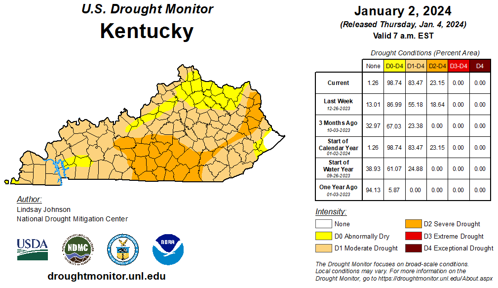 | |
Outside of some snow squalls on the 18th and brief rounds of cold temperatures, it really hasn't felt like winter yet. Looking back at December, preliminary data would place it in the top-10 warmest Decembers of all time. We saw numerous days reach the 50s and 60s, including Christmas Eve when most jumped into the mid to upper 60s, about 20 to 25 degrees above normal. Can we expect winter's arrival anytime soon?
Some folks may get their wish this weekend. Keyword: MAY. Confidence is still not the highest at the moment (winter weather is always a tricky forecast). As it stands now, the best chance for any snow comes on Friday night and into Saturday, primarily across the Bluegrass area and NE KY. Some could see slushy snow, but it doesn't appear to be anything major. Ultimately, elsewhere across the state, most are likely to end up getting rain.
Following another light round on Saturday night/Sunday (mostly rain), a more intense system looks to arrive next workweek, most likely Monday night and into Tuesday. We're still way too far out to be definitive, but this system does appear to have the potential for some excessive rainfall and gusty winds (30-40 mph+). Below is a look at the latest 7-day precipitation forecast from the Weather Prediction Center (most of which is associated with this system), but don't put too much weight into it at this point. A track change can make a big difference in total accumulations or even precipitation type. We do need the rain, but once again, it'll take a lot more to get us back to where we need to be. Keep an eye on this system moving forward.
|  | |
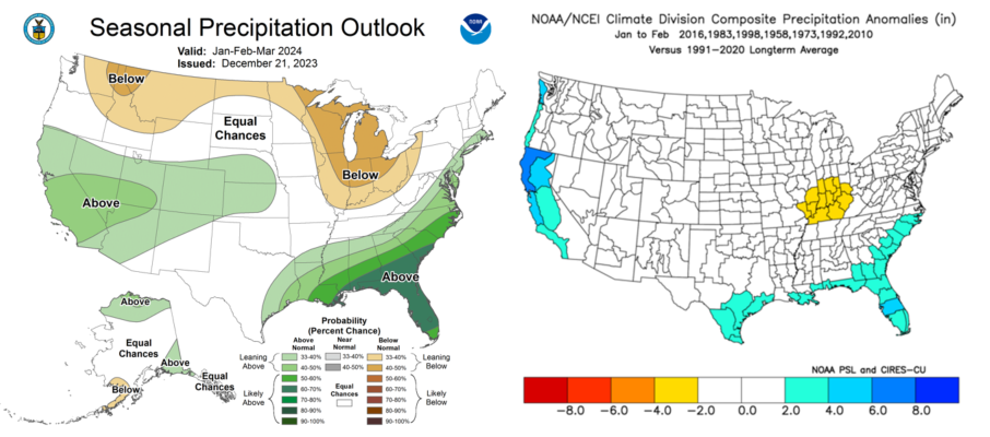
Looking farther out and based on the information above, we need some wet months ahead to address these water deficits. The latest seasonal outlook (Jan-Mar) doesn't necessarily bring good news, nor does the drought outlook (maps below). Both are heavily influenced by the persistence of an El Niño climate pattern. I've discussed this topic in recent write-ups, but, in general, dry conditions are typically favored in our region during these events.
This adds up with the plot below, which shows precipitation anomalies in January and February associated with seven strong El Niño events in the past. We have a bullseye indicating below-normal precipitation across the Southern Ohio Valley. Bottom line, El Nino favors drier conditions early in the year, but other factors can still come into play that can't be forecast at this point. Nonetheless, this will be something to monitor as we approach the 2024 growing season. I'm not overly concerned at the moment, but it's definitely something to keep on the radar.
|  |  | |
Related News from UK and Beyond | |
|
Kentucky Forage News - January 4, 2023
Rising from the rubble: UK Research and Education Center at Princeton reveals remarkable post-tornado transformation - Jordan Strickler with UK Ag Communications, December 11, 2023
Climate extremes hurt Kentucky farmers -The Associated Press, November 19, 2023
UK researcher unraveling the mystery of a potential global agricultural threat in Kentucky and beyond - Jordan Strickler with UK Ag Communications, December 11, 2023
Registration for 2024 KY Turf & Landscape Management Short Course - Kentucky Horticulture Council, February 20-22, 2024
January edition of the KY Monthly Climate Perspective on Drought and Hydrologic Conditions - Kentucky Climate Center, January 4, 2023
Tornadoes and Severe Storms from December 9, 2023 - National Weather Service, Louisville,
| | | | |
