Recent Publications
Pan, J., F. Gao, J. Wang, et al (2024). A main direction-based noise removal algorithm for ICESat-2 photon-counting LiDAR data. Journal of Geodesy. Vol. 98. https://doi.org/10.1007/s00190-024-01887-6
Yang, J., Y. Wu, X. Ma, P. Zhao, W. Yu and Y. Ma (2024). Ocean Surface Wind Speed Estimation Combining Radiometric and Geometric Characteristics of Ocean Waves From ICESat-2 Photon-Counting Lidar. IEEE Journal of Selected Topics in Applied Earth Observations and Remote Sensing. Vol. 17. https://doi.org/10.1109/JSTARS.2024.3452684
Han, K., S. Kim, R. Mehrotra, and A. Sharma (2024). Enhanced water level monitoring for small and complex inland water bodies using multi-satellite remote sensing. Environmental Modelling & Software. Vol. 180. https://doi.org/10.1016/j.envsoft.2024.106169
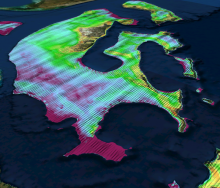
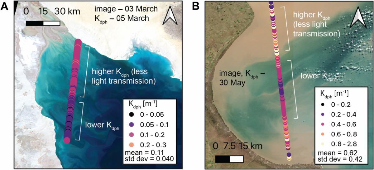
Eidam, E.F., K. Bisson, C. Wang, C. Walker, and A. Gibbons (2024). ICESat-2 and ocean particulates: A roadmap for calculating Kd from space-based lidar photon profiles. Remote Sensing of Environment.Vol. 311. https://doi.org/10.1016/j.rse.2024.114222
Guenther, E., L. Magruder, A. Neuenschwander, D. Maze-England, and J. Dietrich (2024). Examining CNN terrain model for TanDEM-X DEMs using ICESat-2 data in Southeastern United States. Remote Sensing of Environment. Vol. 311. https://doi.org/10.1016/j.rse.2024.114293
Chang, B., H. Xiong, Y. Li, D. Pan, X. Cui, and W. Zhang (2024). ALCSF: An adaptive and anti-noise filtering method for extracting ground and top of canopy from ICESat-2 LiDAR data along single tracks. ISPRS Journal of Photogrammetry and Remote Sensing. Vol. 215. https://doi.org/10.1016/j.isprsjprs.2024.07.002
Zhang, Y. And D. Duan (2024). An approach to estimate tree height using PolInSAR data constructed by the Sentinel-1 dual-pol SAR data and RVoG model. Journal of Electronic Science and Technology. Vol. 22, Issue 3. https://doi.org/10.1016/j.jnlest.2024.100263
Ren, Y., H. Guan, H. Yang, Y. Su, S. Tao, K. Cheng, W. Li, Z. Yang, G. Huang, C. Li, G. Xu, Z. Lu, and Q. Guo (2024). Discovering and measuring giant trees through the integration of multi-platform lidar data. Methods in Ecology and Evolution. Vol. 15, Issue 10. https://doi.org/10.1111/2041-210X.14401
Ticehurst, C., and G. Newnham (2024). Producing Annual Australia-Wide Vegetation Height Images from GEDI and Landsat Data. International Journal of Remote Sensing. Vol. 45, Issue 18. https://doi.org/10.1080/01431161.2024.2391093
Wang, R., Y. Lu, D. Lu, and G. Li (2024). Improving Extraction of Forest Canopy Height through Reprocessing ICESat-2 ATLAS and GEDI Data in Sparsely Forested Plain Regions. GIScience and Remote Sensing. Vol. 61, Issue 1. https://doi.org/10.1080/15481603.2024.2396807
Yin, G. et al. (2024). Adaptive OPTICS Algorithm Denoising ICESat-2 Laser Photon Data. IEEE Geoscience and Remote Sensing Letters. Vol. 2 https://doi.org/10.1109/LGRS.2024.3449446
Franze, S. E., O. B. Andersen, B. Nilsson, and K. Nielsen (2024). Lake gravity anomalies from ICESat-2 laser altimetry and geodetic radar altimetry. Advances in Space Research.https://doi.org/10.1016/j.asr.2024.08.053
Sadeghi Chorsi, T., F. J. Meyer, and T. H. Dixon (2024). Toward long-term monitoring of regional permafrost thaw with satellite interferometric synthetic aperture radar. The Cryosphere. Vol. 18, Issue 8. https://doi.org/10.5194/tc-18-3723-2024
Xu, W., J. Li, D. Peng, J. Jiang, H. Xia, and D. Wen (2024). Comparison of Five Methods for Improving the Accuracy of SRTM3 DEM and TanDEM-X DEM in the Qinghai-Tibet Plateau Using ICESat-2 Data.International Journal of Digital Earth. Vol. 17, Issue 1. https://doi.org/10.1080/17538947.2024.2391036
Sadeghi Chorsi, T., F. J. Meyer and T.H. Dixon (2024). Toward long-term monitoring of regional permafrost thaw with satellite interferometric synthetic aperture radar. The Cryosphere. Vol. 18, Issue 8. https://doi.org/10.5194/tc-18-3723-2024
Xu, W., J. Li, D. Peng, J. Jiang, H. Xia, and D. Wen (2024). Comparison of Five Methods for Improving the Accuracy of SRTM3 DEM and TanDEM-X DEM in the Qinghai-Tibet Plateau Using ICESat-2 Data.International Journal of Digital Earth. Vol. 17, Issue 1 https://doi.org/10.1080/17538947.2024.2391036
Kamath, H.G., M. Singh, N. Malviya et al. (2024). GLObal Building heights for Urban Studies (UT-GLOBUS) for city- and street- scale urban simulations: Development and first applications. Scientific Data. https://doi.org/10.1038/s41597-024-03719-w
Yang, H., Z. Qin, Q. Shu, L. Xi, C. Xia, Z. Wu, M. Wang, and D. Duan (2024). Estimation of the Aboveground Carbon Storage of Dendrocalamus giganteus Based on Spaceborne Lidar Co-Kriging. Forests. Vol. 15, Issue 8. https://doi.org/10.3390/f15081440
Lowell, K. and J. Hermann (2024). Accuracy of Bathymetric Depth Change Maps Using Multi-Temporal Images and Machine Learning. Journal of Marine Science and Engineering. Vol. 12, Issue 8. https://doi.org/10.3390/jmse12081401
Kacimi, S., and R. Kwok (2024). Two Decades of Arctic Sea-Ice Thickness from Satellite Altimeters: Retrieval Approaches and Record of Changes (2003–2023). Remote Sensing. Vol. 16, Issue 16. https://doi.org/10.3390/rs16162983
Agca, M., A. Yucel, E. Kaya et al. (2024). Machine learning algorithms for building height estimations using ICESat-2/ATLAS and Airborne LiDAR data. Earth Science Informatics. https://doi.org/10.1007/s12145-024-01429-w
Chen, Y., Y. Wang, L. Li., Y. Cui, X. Duan, and D. Long (2024). Monthly monitoring of inundated areas and water storage dynamics in China's large reservoirs using multisource remote sensing. Water Resources Research. Vol. 60, Issue 8. https://doi.org/10.1029/2023WR036450
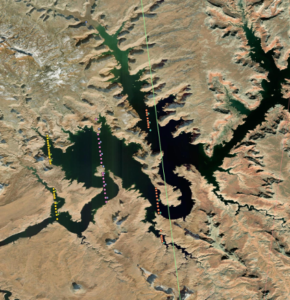
Fan, M. et al (2024). Enhanced lake elevation mapping using a zone-based method. Environmental Research Letters. Vol. 19, Issue 9. https://doi.org/10.1088/1748-9326/ad6620
Wang, Z., S. Nie, C. Wang, B. Fu, X. Xi, and B. Yang (2024). A novel bathymetric signal extraction method for photon-counting LiDAR data based on adaptive rotating ellipse and curve iterative fitting.International Journal of Applied Earth Observation and Geoinformation. Vol. 132. https://doi.org/10.1016/j.jag.2024.104042
Chen, L., G. Zhang, S. Xing, Z. Wang, R. Kong and Q. Xu (2024). Satellite Retrieval of LiDAR Attenuation Coefficient From ICESat-2 and Sentinel-3 Based on Machine Learning: Inland Waters. IEEE Geoscience and Remote Sensing Letters. Vol. 21. https://doi.org/10.1109/LGRS.2024.3436833
Zhang, X., Y. Ma, Z. Li, and J. Zhang (2024). Synergistic detection of chlorophyll-a concentration vertical profile by spaceborne lidar ICESat-2 and passive optical observations. International Journal of Applied Earth Observation and Geoinformation. Vol. 132. https://doi.org/10.1016/j.jag.2024.104035
Lyu, H., and F. Tian (2024). Satellite-based water surface slope over a small mountain river in northern China. Journal of Hydrology. Vol. 639. https://doi.org/10.1016/j.jhydrol.2024.131576
Li, Q., J. An, Z. Xing, Z. Wang, P. Jiang, B. Yan, Y. Wu, and B. Zhang (2024). Three-dimensional dynamic monitoring of crevasses based on deep learning and surface elevation reconstruction methods.International Journal of Applied Earth Observation and Geoinformation. Vol. 132. https://doi.org/10.1016/j.jag.2024.104017
Yao, S., K. Tan, Y. Wang, W. Zhang, S. Liu, and J. Yang (2024). Estimating terrain elevations at 10 m resolution by Integrating random forest machine learning model and ICESat-2, Sentinel-1, and Sentinel-2 satellite remotely sensed data. International Journal of Applied Earth Observation and Geoinformation. Vol. 132. https://doi.org/10.1016/j.jag.2024.104010
Malambo, L. and S. Popescu (2024). Mapping vegetation canopy height across the contiguous United States using ICESat-2 and ancillary datasets. Remote Sensing of Environment. Vol. 309. https://doi.org/10.1016/j.rse.2024.114226
Chang, J., Y. Jiang, M. Tan, Y. Wang, and S. Wei (2024). Building Height Extraction Based on Spatial Clustering and a Random Forest Model. ISPRS International Journal of Geo-Information. Vol. 13, Issue 8. https://doi.org/10.3390/ijgi13080265
Xia, H., J. Wu, J. Yao, N. Xu, X. Gao, Y. Liang, J. Yang, J. Zhang, L. Gao, W. Jin, et al (2024). Dynamic Inversion Method of Calculating Large-Scale Urban Building Height Based on Cooperative Satellite Laser Altimetry and Multi-Source Optical Remote Sensing. Land. Vol. 13, Issue 8. https://doi.org/10.3390/land13081120
Xu, Y., T. Zhou, J. Zeng, H. Luo, Y. Zhang, X. Liu, Q. Lin, and J. Zhang (2024). Spatial Pattern of Forest Age in China Estimated by the Fusion of Multiscale Information. Forests. Vol. 15, Issue 8. https://doi.org/10.3390/f15081290
Magruder, L., A. R. Reese, A. Gibbons, J. Dietrich and T. Neumann (2024). ICESat-2 onboard flight receiver algorithms: On-orbit parameter updates the impact on science driven observations. Earth and Space Science. Vol 11, Issue 7. https://doi.org/10.1029/2024EA003551
Yang, J., H. Zheng, Y. Ma, X. Liu and S. Li (2024). Instrument Radiometric Correction of Laser Signals and Background Noise for ICESat-2 Photon-Counting Lidar. IEEE Geoscience and Remote Sensing Letters. Vol. 21. https://doi.org/10.1109/LGRS.2024.3432732
Qin, Z., H. Yang, Q. Shu, J. Yu, L. Xu, M. Wang, C. Xia, and D. Duan (2024). Estimation of Leaf Area Index for Dendrocalamus giganteus Based on Multi-Source Remote Sensing Data. Forests. Vol. 15, Issue 7. https://doi.org/10.3390/f15071257
Ai, B., X. Liu, Z. Wen, L. Wang, H. Ma and G. Lv (2024). A Novel Coral Reef Classification Method Combining Radiative Transfer Model With Deep Learning. IEEE Journal of Selected Topics in Applied Earth Observations and Remote Sensing. Vol. 17. https://doi.org/10.1109/JSTARS.2024.3430899
Chen, S. et al. (2024). A Novel Multidimensional Statistics Denoising Algorithm Based on Gaussian Mixture Model for Photon-Counting LiDAR Data. IEEE Journal of Selected Topics in Applied Earth Observations and Remote Sensing. Vol. 17. https://doi.org/10.1109/JSTARS.2024.3430470
Li, M., C. Ke, B. Cheng, J. Ma, H. Jiang, and X. Shen (2024). Inter-comparisons of Arctic snow depth products. International Journal of Digital Earth. Vol. 17, Issue 1. https://doi.org/10.1080/17538947.2024.2376286
Yan, Z., Q. Ji, B. He, Y. Chen, Y. Wang, and X. Pang (2024). A Combined Multi-Source Data and Deep Learning Approach for Retrieving Snow Depth on Antarctic Sea Ice during the Melting Season.International Journal of Digital Earth. Vol. 17, Issue 1. https://doi.org/10.1080/17538947.2024.2376260
Dømgaard, M., K. Kjeldsen, P. How, et al. (2024). Altimetry-based ice-marginal lake water level changes in Greenland. Communications Earth and Environment. https://doi.org/10.1038/s43247-024-01522-4
North, R., and T. T. Barrows (2024). High-resolution elevation models of Larsen B glaciers extracted from 1960s imagery. Scientific Reports. https://doi.org/10.1038/s41598-024-65081-6
Leite, R.V., C. Amaral, C. S. R. Neigh, D. N. Cosenza, C. Klauberg, A. T. Hudak, L. Aragão, D. C. Morton, S. Coffield, T. McCabe, and C. A. Silva (2024). Leveraging the next generation of spaceborne Earth observations for fuel monitoring and wildland fire management. Remote Sensing in Ecology Conservation. https://doi.org/10.1002/rse2.416
Jia, K., Y. Ma, J. Zhang, B. Wang, X. Zhang and A. Cui (2024). A Denoising Methodology for Detecting ICESat-2 Bathymetry Photons Based on Quasi Full Waveform. IEEE Transactions on Geoscience and Remote Sensing. Vol. 62. https://doi.org/10.1109/TGRS.2024.3422502
Li, G., C. Zhao, B. Li, J. Li, X. Liu, J. Lou, M. Yan, and B. Wang (2024). Stepwise Estimation of Height Change Time Series and Two-Dimensional Surface Deformation over Mountain Excavation and City Construction Region with TS-InSAR Technique. International Journal of Applied Earth Observation and Geoinformation. Vol. 131. https://doi.org/10.1016/j.jag.2024.103982
Osorio, M., A. Agesta, T. Bösch, N. Casaballe, A. Richter, L. M. A. Alvarado, and E. Frins (2024). Measurement Report: Combined Use of MAX-DOAS and AERONET Ground-Based Measurements in Montevideo, Uruguay, for the Detection of Distant Biomass Burning. Atmospheric Chemistry and Physics. Vol. 24, Issue 12. https://doi.org/10.5194/acp-24-7447-2024
Dandabathula, G., K. Ghosh, R. Hari, et al. (2024). Physical features of Adam’s Bridge interpreted from ICESat-2 based high-resolution digital bathymetric elevation model. Scientific Reports. https://doi.org/10.1038/s41598-024-65908-2
Dandabathula, G., R. Hari, J. Sharma, et al. (2024). A High-Resolution Digital Bathymetric Elevation Model Derived from ICESat-2 for Adam’s Bridge. Scientific Data. https://doi.org/10.1038/s41597-024-03550-3
Suo, Z., Y. Lu, J. Liu, J. Ding, Q. Wang, L. Li, W. Ju and M. Li (2024). Extracting iceberg freeboard using shadow length in high-resolution optical images. Geo-Spatial Information Science. Vol. 27, Issue 3. https://doi.org/10.1080/10095020.2024.2360525
Li, B., H. Xie, S. Liu, Y. Xi, C. Liu, Y. Xu, et al. (2024). A high-quality global elevation control point dataset from ICESat-2 altimeter data. International Journal of Digital Earth. Vol. 17, Issue 1. https://doi.org/10.1080/17538947.2024.2361724
Huang, J., Y. Zhang and Y. Yu (2024). Mathematical Model Guided Interpolation for Mapping SRTM Understory Terrain by Integrating ICESat-2 Data. IEEE Geoscience and Remote Sensing Letters. Vol. 21. https://doi.org/10.1109/LGRS.2024.3412396
Musaeus, A. F., C. M. M. Kittel, J. Luchner, M. C. Frias, and P. Bauer-Gottwein (2024). Hydraulic river models from ICESat-2 elevation and water surface slope. Water Resources Research. Vol. 60, Issue 6. https://doi.org/10.1029/2023WR036428
Perry, J. S., A. L. Neuenschwander, M. J. Holwill, and L. A. Magruder (2024). A deep residual network implementation for satellite-derived altimetry identification and classification. Proceedings SPIE.https://doi.org/10.1117/12.3021196
Guenther, E. J., A. L. Neuenschwander, L. A. Magruder, and D. Maze-England (2024). Correcting SAR-derived DEMs with ICESat-2 using deep learning. Proceedings SPIE.https://doi.org/10.1117/12.3013897
Zhang, X., S. Guo, B. Yuan, et al (2024). Error-Reduced Digital Elevation Model of the Qinghai-Tibet Plateau using ICESat-2 and Fusion Model. Scientific Data. Scientific Data.https://doi.org/10.1038/s41597-024-03428-4
Meng, W., F. Wang, J. Chen, W. Sun, and J. Yuan (2024). Comparison and accuracy evaluation of denoising methods for ICESat-2 shallow-sea photon point clouds. Proceedings SPIE.https://doi.org/10.1117/12.3032168
Van der Sluijs, J., E. Saiet, R.H. Fraser, S. V. Kokelj, and C.N. Bakelaar (2024). Validation of beyond visual-line-of-sight drone photogrammetry for terrain and canopy height applications. Remote Sensing Applications: Society and Environment. Vol. 35. https://doi.org/10.1016/j.rsase.2024.101266
GUO Songtao, XING Shuai, ZHANG Guoping, KONG Ruiyao, and CHEN Li (2024). Bathymetric inversion model for fusion of heterogeneous satellite remote sensing data. Bulletin of Surveying and Mapping.https://doi.org/10.13474/j.cnki.11-2246.2024.0504
Ghorbani, M., A. A. Darvish Sefat, M. Namiranian, and M. Rajabpour Rahmati (2024). Accuracy investigation of forest canopy height estimation by ICESat-2 satellite in Kheyroud forest. Forest and Wood Products. Vol. 77, Issue 1. https://doi.org/10.22059/jfwp.2024.368338.1269
Huang, X., F. Cheng, Y. Bao, C. Wang, J. Wang, J. Wu, J. He, and J. Lao (2024). Urban building height extraction accommodating various terrain scenes using ICESat-2/ATLAS data. International Journal of Applied Earth Observation and Geoinformation. Vol. 130. https://doi.org/10.1016/j.jag.2024.103870
Chen, Y., X. Cui, Q. Gu, Y. Zhou, H. Zhao, H. Zhang, S. Ma, P. Xu, H. Frielinghaus, L. Wu, C. Liu, W. Sun, S. Yang, M. Hu, Q. Liu, and D. Liu (2024). This is MATE: A Multiple scAttering correcTion rEtrieval algorithm for accurate lidar profiling of seawater optical properties. Remote Sensing of Environment.Vol. 307. https://doi.org/10.1016/j.rse.2024.114166
Li, J., S. Chu, Q. Hu, Y. Cong, J. Cheng, H. Chen, L. Cheng, G. Zhang, and S. Xing (2024). Land-sea classification based on the fast feature detection model for ICESat-2 ATL03 datasets. International Journal of Applied Earth Observation and Geoinformation. Vol. 130. https://doi.org/10.1016/j.jag.2024.103916
|