|
Oregon Coast Alliance Newsletter
|
A Sixty-Acre Quarry for Mining 440,000 Tons of Rock in Curry County?
|
|
| Sixes River, Oregon. Courtesy of OR State Archives, Gary Halvorson/Wikimedia |
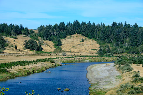
Curry County received an application from the Kiewit Infrastructure West Company to develop a 60-acre rock quarry, with intent to mine more than 440,000 tons of rock from the site over the lifetime of the quarry, probably some twenty-five years. That's right, 440,000 tons. According to the County staff report, there will be a maximum of forty loaded trucks per day leaving the site, using private logging roads, Sixes River Road and Highway 101 to haul the large rocks to Coos Bay. There will also be a rock crusher on site, and of course associated infrastructure such as site clearing, road-building and placement of various buildings, such as a maintenance facility and lubrication storage unit. The 320-acre property is owned by Andrew and Diane Foster.
This is not a proposal for gravel mining. This to be a mine for jetty stone, "for several major projects on the west coast including the emergency repair on the mouth of the Columbia River, and providing a source of quarry stone and crushed rock for local riprap and construction projects." For such an enormous project, Kiewit will also need permits from the Oregon Department of Geology and Mineral Industries and the Department of State Lands, among others.
Curry County Planning Commission held an initial hearing June 20th. The County's staff report was an exercise in oversight failure, simply recommending the County approve the permit, then get copies of all the other permits and review them. The county said that if Kiewit fulfilled the restrictions and requirements of other agencies, they would also be complying with the Curry County Zoning Ordinance! But the county cannot pass the buck like that. It must perform an analysis of whether an application meets its own standards. This is especially true for a major mega-quarry in a very rural area that will have major effects on the land, water table and rural community.
ORCA will be following this proposal closely through the many upcoming permitting processes.
|
Gravel Mining on the Pistol River - Again
|
|
| Mouth of the Pistol River, Oregon. Courtesy of Michelle Kinsey Bruns/Wikimedia |
Curry County also received an application for gravel mining on a gravel bar in the Pistol River. Curiously, the application has no indication of how much gravel Ronald Adams wants to mine, how he would mine, nor any indication, apart from vague statements, of how instream mining would affect the Pistol in this area. The application just says, "The impact of this operation should be mostly positive. The Waterway of this area of pistol [sic] River has been in disarray for many years...We will work with fish and wildlife to make improvements whenever possible. we Can't solve all problems but with the help of odf&w everything I plan on doing will be a win-win. Again anything we do will be an improvement over the way it is now."
The Pistol River in this area, about a mile above the estuary, is highly abraded and eroded, thanks to poor riparian management by some riverside owners along much of the lower river. However, it is a fish-bearing river, hosting runs of fall chinook, steelhead and sea-run cutthroat, as well as Southern Oregon Northern California Coastal (SONCC) coho. It is significant that in 1997 SONCC coho were listed as a federally threatened species; thus gravel mining in this habitat, if any, must be done with great care, expertise and attention to river structure. Much public money has gone into restoring fish habitat, and these successful efforts must not be decimated by a vague and incomplete gravel mining proposal.
The county staff report says the applicant proposes to mine about 10,000 cubic yards, without indicating where that figure comes from. There have been efforts to mine on the Pistol before, most recently in 2003. That application included 50,000 cubic yards instream mining per year, and an asphalt batching plant. The proposal violated the National Marine Fisheries Service's National Gravel Extraction Policy, which describes the effects of riverine gravel removal and its impacts on salmonids. Its scientific conclusions have stood the test of time.
This current application makes no mention at all of that policy document, nor of the US Forest Service 1998 Pistol River Watershed Assessment or the Pistol River Watershed Action Plan of 2001, which seek to chart a better course for the Pistol. Nor does the application discuss how gravel mining will assist SONCC coho in their struggle for survival in our south coast rivers.
The county has again completely abandoned its oversight of the project, merely parroting the applicant and making conclusory statements that the proposal meets the requirements of the Curry County zoning ordinance. ORCA is working with many other concerned members of the public to ensure this application receives the scrutiny it deserves.
|
Newport's Sand Cliffs and Development Proposals - Again
|
|
| Yaquina Bridge Sunset at Newport. Courtesy Port of Newport |
On June 3, 2019, Community Development Director Derrick Tokos announced his approval of a Geologic Permit submitted by J.T. Roth of Portland to develop a site on the 1500 block of Spring Street. The property is located on the west side of Spring Street, in an area previously identified by the State of Oregon (Department of Geology and Mineral Industries) as an "Active erosion hazard zone" and "Very high - existing landslide" area.
Mr. Roth's proposal includes extensive land and tree clearing, a 5' concrete retaining wall, a 4' boulder wall, and construction of two 5,400 sq. ft. duplexes and a 3,500 sq. ft. single-family house.
The proposed plan calls for the removal of most, if not all, of the trees and vegetation on these three lots. Trees and their root structures are recognized as stabilizing in a slide-prone landscape. The plan as submitted calls for "Public right of way to be filled at 100' elevation" and "the area from the edge of pavement and property line is to be backfilled with compacted sand and/or rock and that all organics are to be removed before placement of fill."
These potential geologic hazards (land slides, erosion, tsunami, earthquake) are not unique to Mr. Roth's property at 1500 NW Spring Street. In 2008 a house was built nearby at 1600 NW Spring Street.
A 1998 geologic report for the 1600 NW Spring Street property by Geotechnical and Civil Engineer, Roy Arnoldt, states:
"...development should be focused on maintaining the existing topography with only minor changes to it. In this manner the existing stability will not be decreased."
And again, in a 2003 report for 1600 NW Spring Street by H.G. Schlicker & Associates, Engineering Geologist J. Douglas Gless states:
"At this time, we recommend that the site not be developed due to the high risk of future ground movement."
And a third geologic report, from 2007 also for 1600 NW Spring Street, by Pinnacle Engineering, Dave Leonard, Geotechnical Engineer states:
"Construction of permanent occupied structures is not permitted north or west of the proposed structure."
Although Mr. Roth's proposed structures are approximately 150 feet to the south of the above referenced property, they are in their entirety located to the west - that is, closer to the ocean - of the 1600 NW Spring Street structure.
The City of Newport's Comprehensive Plan acknowledges that: "Often an apparently stable slope can be reactivated by the addition of houses and streets."
ORCA notes that the proposed development on Spring Street
is in the area
of the notorious debacle in Newport in the 1980s known as Jump-off Joe, in which
the
foundation for a condo development underway eroded and collapsed under the buildings,
along with the sand cliff it sat on.
Several bankruptcies resulted, including of Richard and Barbara Anderson, the owners. In addition, the state revoked the license of the Andersons' geologist, who certified the site was geologically stable.
Newport Municipal Code clearly states that the City's responsibility is to
"promote the public health, safety and general welfare by minimizing public and private losses due to earth movement hazards and limiting erosion and related environmental damage, consistent with Statewide Planning Goals 7 and 18 and the Natural Features Section of the Newport Comprehensive Plan." Newport residents are asking City Council to review the Director's decision to approve the geological report, reminding them that a similar disaster as Jump-off Joe could happen again at any time.
|
|