Planning Commission logo (white)

COUNTY PLANNING NEWSLETTER

June 2025

2025 Data Book Now Available

map of building density in Cuyahoga County

County Planning is pleased to present Our Communities: The 2025 Data Book, the latest publication in the Data Book series. It provides helpful insights and information about Cuyahoga County and its communities.


The Data Book series assists local communities by providing recent, regularly updated data in an easily accessible format. The new edition provides 62 indicators covering demographics, the economy, housing, land use, transportation, and health for the county's cities, villages, and townships.


New indicators introduced in the 2025 edition include:


  • Living arrangements of older adults, a look at the housing situations for people age 65 and up
  • Building density, a calculation of building area per land area (depicted above)
  • Level of traffic stress, a measure of stress levels for cyclists who ride on roadways
  • Food insecurity, areas where people are unable to afford nutritionally adequate and safe foods


Please let us know if you use the Data Book in your work or if you have suggestions for future editions.

E. 22nd Street Current Conditions Assessment

East 22nd Street

Photo: Cuyahoga County

County Planning performed a Current Conditions Assessment of the E. 22nd Street Corridor at the request of the City of Cleveland Planning Commission. This assessment, a point-in-time snapshot of the corridor area, coordinated many concurrent, highly consequential planning efforts by a wide variety of stakeholders to identify opportunities for collaborative planning, integrated services, and coordinated implementation among stakeholders to achieve mutually desirable outcomes.


The study included four phases: Data Analysis, Existing Plans Review, Stakeholder Engagement, and Opportunity Identification. The Data Analysis phase reviewed infrastructure such as nearby transit and transportation networks, roadway pavement conditions, and traffic volumes. It also measured the inflow and outflow of workers to the area and the employment sectors represented. Land use and zoning as well as demographics and housing types enriched the information gathering to present a real world view of the corridor.

South Euclid MU-TOD Zoning Code Update

oblique aerial photo of South Euclid's Rock the Block event

Photo: City of South Euclid

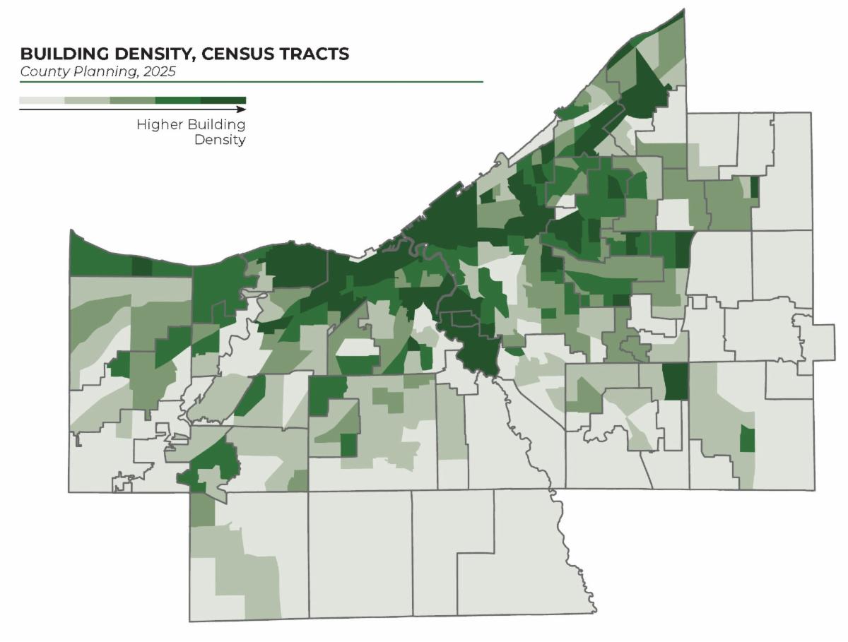
In partnership with the South Euclid Department of Planning & Development, County Planning drafted an update to the South Euclid municipal zoning code for a Mixed-Use Transit-Oriented Development (MU-TOD) Zoning District. Recently adopted by South Euclid, the MU-TOD Zone will guide development and redevelopment in key targeted commercial areas where a mix of uses and a diversity of housing types could expand mobility options, promote transit use, and deliver walkable, pedestrian-focused neighborhood development. The MU-TOD Zoning District allows for flexibility to enhance any commercial district citywide and could be applied along transit corridors where appropriate. 


The MU-TOD Zone will take the place of the Mayfield-Green (M-G) Zoning District, which serves as the city’s Downtown commercial area and is located along transit corridors suitable for higher-density, mixed-use, and pedestrian-friendly development. The South Euclid Planning Commission will utilize the MU-TOD zoning code regulations in its role to review proposed developments in the district. 


The MU-TOD Zone offers more appropriate, less automobile-centric regulations aligned with County Planning's best practices for TOD. For example, the zoning district allows for reductions to parking minimums where appropriate. The regular review of standard development items such as building setbacks, building orientation, waste disposal, landscaping, parking lot screening, driveway locations, etc. will continue as expected using these updated standards.

Recent Conference Presentations

  • James Sonnhalter of County Planning participated in the annual conference of the Great Lakes and St. Lawrence Cities Initiative (GLSLCI), held May 14-16 in Milwaukee, and co-presented the session called "Coming Together: Scaling Up Waterfront Planning". James’ co-presenters were Euclid Mayor Kirsten Holzheimer Gail, SmithGroup Director of Waterfront Planning Jason Stangland, and GLSLCI Senior Coastal Programs Manager Zoe Kuntze.
  • The County Planning team presented at two sessions of the Cleveland APA Planning & Zoning Workshop held May 15th. Rachel Novak, AICP and Paul Triolo, AICP presented on the topic of Community Surveys with Orange Village Mayor Judson Kline. Their discussion highlighted the 2024 Orange Village Community Survey. Micah Stryker, AICP presented a session on the topic of the North Olmsted Mall Area Mixed-Use Overlay District with Max Upton, North Olmsted Community and Economic Development Director. 

Bike-with-a-Mayor Returns for 2025

This year's Bike-with-a-Mayor events are organized by individual communities, in coordination with Elaine Price of County Planning. These events highlight existing trails and potential new trails identified in the Cuyahoga Greenway Plan and offer participants an opportunity to chat with community leaders. Bike-with-a-Mayor events will be held for five communities in June. 

Thanks for taking the time to read our newsletter! If you found the information valuable, please consider forwarding it to a friend or colleague. Please let us know if there are opportunities for us to collaborate with you.

Cuyahoga County Planning Commission

2079 East 9th Street, Suite 5-300

Cleveland, Ohio 44115

216-443-3700

info@countyplanning.us

Planning Commission seal (white)

Did someone forward this message to you? Get your own subscription to receive future newsletters.

Facebook  Instagram  LinkedIn  YouTube