Newsletter banner image with "Landsat Science News Digest" in white text on top of a Landsat image. White text reads "May 2025" at the bottom right of the graphic.

Forty Years of Change in Louisiana's Wetlands

May 19, 2025

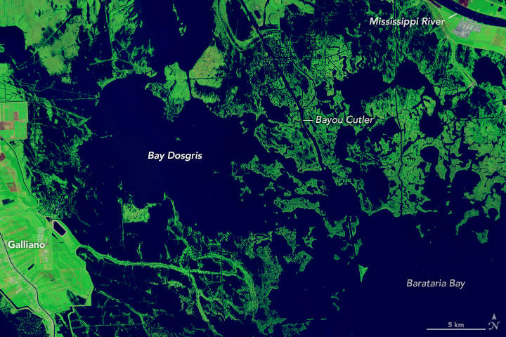
Landsat image of Bay Dosgris in 2024.

In the early 1800s, pirate Jean Lafitte smuggled goods and slaves through Louisiana’s muddy coastal waters, navigating the bayous, bays, and lakes up to New Orleans. However, any map he used would likely lead today’s sailors astray. Landsat images show that in the past 40 years alone, Louisiana’s coastal areas have undergone substantial changes.

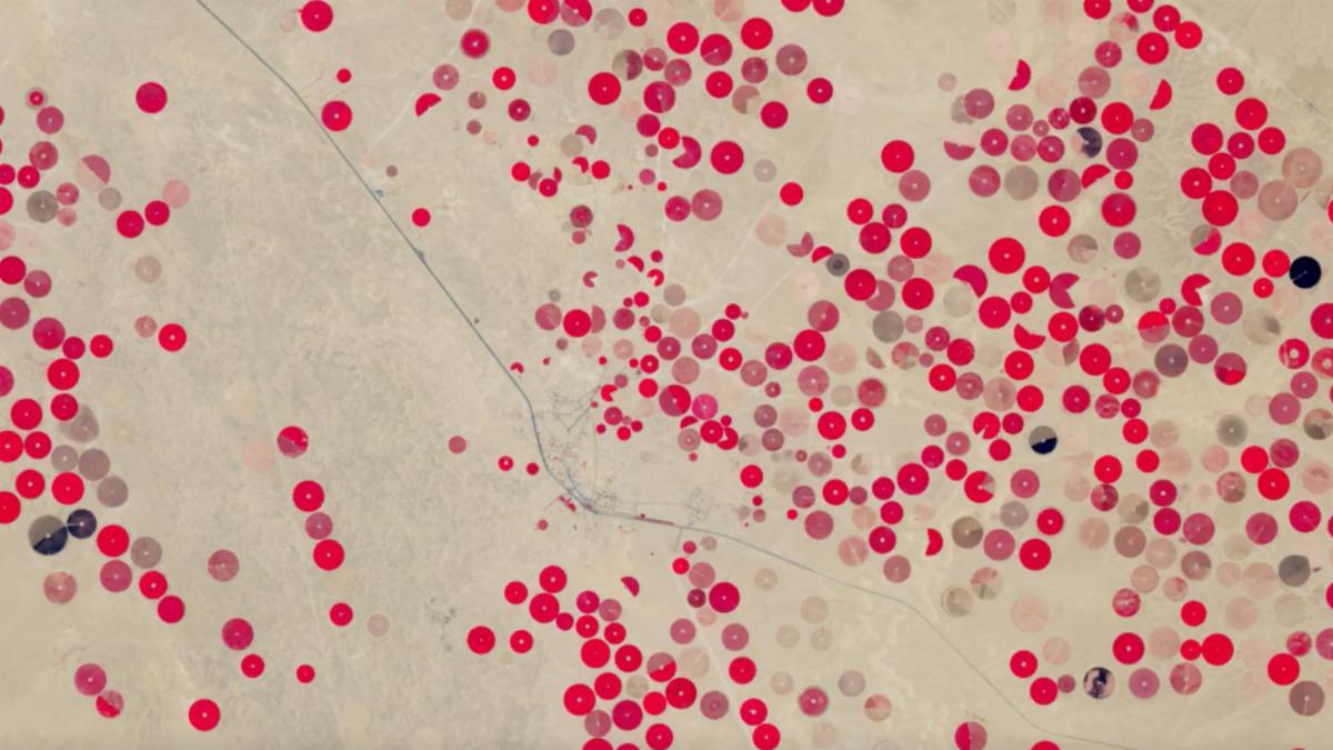
False-color Landsat image of crop fields in Saudi Arabia. Red circles show fields with healthy vegetation against a beige background of desert sand.

May 22, 2025

Saudi Arabia's Desert Agriculture


In a time-series of crop fields in Saudi Arabia, you can watch as crop fields burst with life and then are harvested. Researchers use near-infrared wavelengths to measure seasonal vegetation health, as healthy vegetation reflects high amounts of near-infrared light due to chlorophyl absorption.

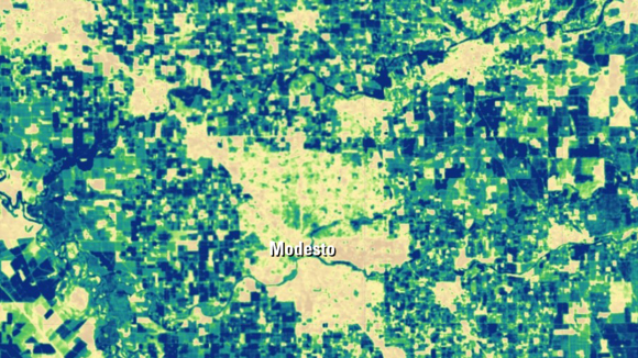
Map image of 2020 annual actual evapotranspiration (ETa) in the Modesto, California, area, as determined by the SSEBop ET model from the USGS Earth Resources Observation and Science (EROS) Center.

May 21, 2025

Landsat Helps Grow High-Quality Wine Grapes

Source: Earth Resources Observation and Science (EROS) Center


Using Landsat’s thermal imagery, researchers at Gallo Winery have been able to better understand vineyard water needs and optimize irrigation.

“If you had one dime to call from a phone booth and you needed imagery, Landsat’s the imagery source to call. Landsat provides the longest-running, well-calibrated and trusted source of information.”


Nick Dokoozlian, Vice President, Viticulture, Chemistry and Enology at E&J Gallo Winery, May 28, 2025

Landsat at Work: Conserving Water and Growing High Quality Grapes

Upcoming Events

The Landsat Communications and Public Engagement Team will be at the following event in June 2025:

American Library Association (ALA) 2025 meeting logo.

American Library Association Annual Conference


June 27-30, 2025

Pennsylvania Convention Center

Philadelphia, Pennsylvania


The Landsat team will be at the NASA booth on

6/27 from 5:30pm-7pm

6/28 from 9am-5pm

6/29 from 9am-5pm

6/30 from 9am-2pm

PUBLICATION SPOTLIGHT


Using Landsat 8 and 9 operational land imager (OLI) data to characterize geometric distortion and improve geometric correction of Landsat Multispectral Scanner (MSS) imagery


| Yan and Roy, 2025


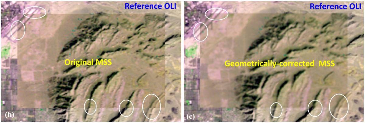
Yan and Roy, 2025 presents a novel method to correct geometric inaccuracies in imagery from the Multispectral Scanner (MSS) on Landsat 1–5. The geometric inaccuracies in these data, collected from 1972–1992, has limited research seeking to analyze long-term changes. Their method uses recent Operational Land Imager (OLI) imagery acquired on Landsat 8 and 9 as references to characterize and correct MSS image geometric inaccuracies. By matching a large number of images—182 Landsat 1, 2, 3, 4, and 5 MSS and 38 Landsat 8 and 9 OLI images—they identified geometric distortions in the MSS imagery that ranged from 21.0 m on Landsat 5 images to 43.2 m on Landsat 1 images. After correction, these errors were reduced to less than 14 m for all five Landsat MSS sensor generations. This study focused on sites in the U.S. but could be applied to other areas of interest in the MSS archive. Fixing geometric distortions in MSS imagery will allow researchers to perform more accurate analyses of land surface change stretching back more than 50 years to 1972.


On the left is an original Landsat 1 MSS image superimposed on a Landsat 9 reference image. On the right is the geometrically-corrected MSS image superimposed on the Landsat 9 reference image. Areas where the new alignment is visible are circled in white. Image credit: Yan and Roy, 2025

Find more selected Landsat publications on our website.

NASA's Earth Observatory

Selected Landsat Images

May 28, 2025

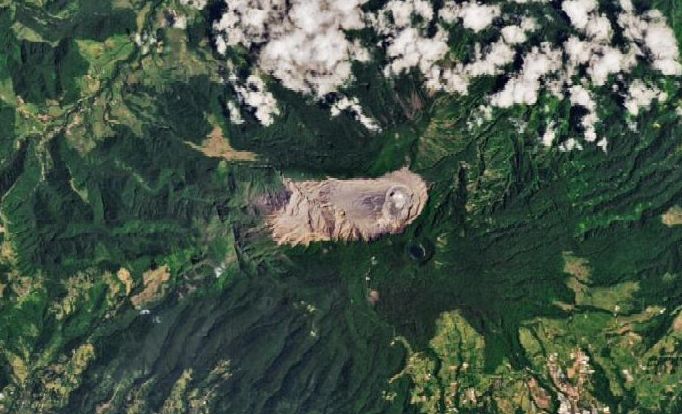
Roiling Poás Volcano


The restless Costa Rican volcano sustains a hot, ultra-acidic crater lake that shares similarities to Martian environments.

The summit area of Volcán Poás (Poás volcano) occupies the center of a detailed satellite image. An elongated area oriented horizontally appears tan with no vegetation; a round crater is located in the right portion of this area. Rugged-looking light and dark green mountain slopes take up the rest of the image, and some clouds are present across the top edge.

May 23, 2025

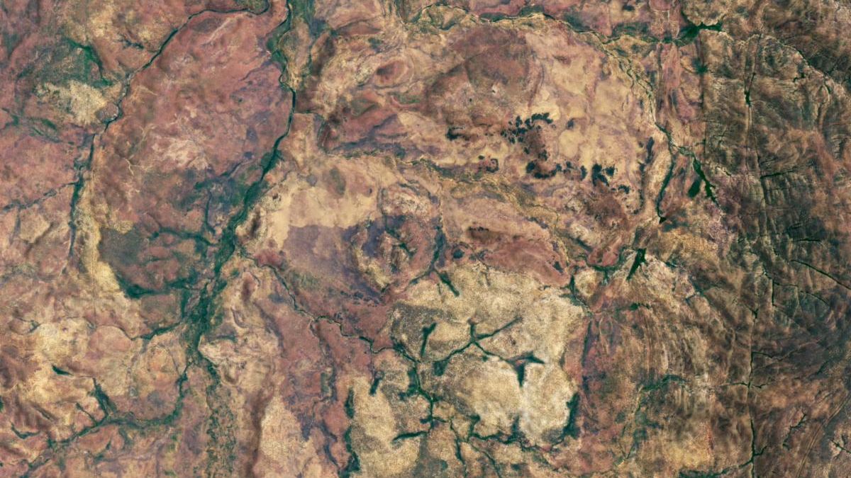
An Impact Crater Hiding in Plain Sight


Much of the Goyder impact structure has eroded away, but there are remnants in Australia’s Northern Territory.

A satellite image shows the land surface of part of Australia’s Northern Territory. The image highlights the location of the Goyder impact structure, the eroded remnants of the central uplift portion of an impact crater. The central uplift remnants appear as small hills in the center of the image, with a light-colored ring of sandstone surrounding them. Most of the dry-looking surface is tan or red, but stream valleys are green.

May 16, 2025

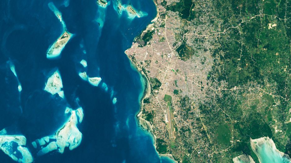
Digging Into the History of Stone Town


Satellite images of the ancient city in Zanzibar highlight urbanization patterns and help researchers find new archaeological sites. 

The image of Stone Town shows the city in 2024. In this image, the urban area is considerably larger, having expanded inland in all directions.

May 3, 2025

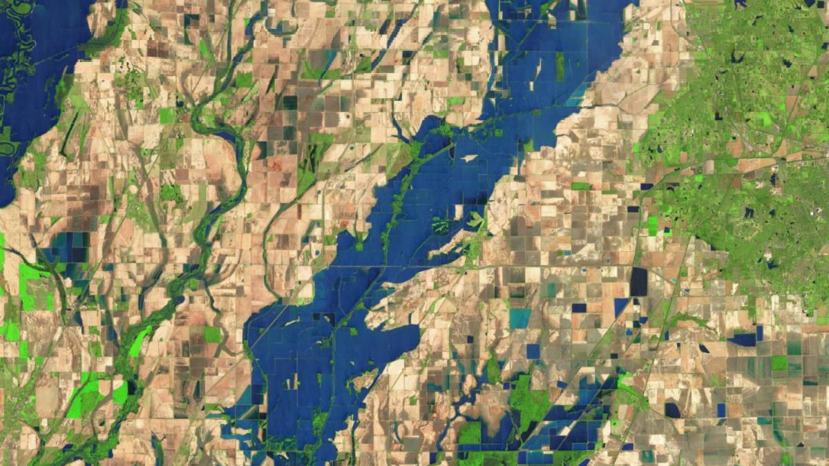
Arkansas Farmers Face Lingering Floodwaters


Many growers have been forced to replant as a prolonged flood killed off crops in the Arkansas Delta.

A more recent false-color satellite image shows the same area on April 15, 2025. Now, floodwaters from the Cache River spill across farmland along the banks of the river. Water appears blue and vegetation is green.

New Growth on the Klamath

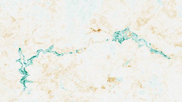
Change in NDVI in the Klamath River between 2024 and 2025. Areas around the river appear bright green, representing the growth of vegetation in the wake of the river drawdown.

Between October 2023 and October 2024, the four dams comprising the Klamath Hydroelectric Project were taken down, opening more than 400 miles of salmon habitat. By spring 2025, flowers could be seen blooming on Klamath’s riverbanks. Looking at the changes in NDVI, we can track the vegetation growth on the newly-exposed land.


+ The Greening of the Klamath

Did someone forward this newsletter to you? Subscribe here if you'd like to be on our mailing list.

landsat.gsfc.nasa.gov

Facebook  X