pers.jpg
updated asprs logo.png

PE&RS May 2025

View This Month's Issue of PE&RS here:

https://www.asprs.org/asprs-publications/pers-issues

Divider for newsletter.jpg

Highlight


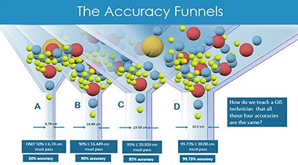
Overview of the ASPRS Positional Accuracy Standards for Digital Geospatial Data


Edition 2, Version 2 (2024)

The Global geospatial community relies on the American Society of Photogrammetry and Remote Sensing (ASPRS) when it comes to education and standardization. Since the early eighties, ASPRS championed the development of accuracy standards for geospatial data. Early versions of such standards, including the legacy standards of 1990, were designed for the mapping making practices of that era and characterized by paper-based maps. In 2014, ASPRS published the new Positional Accuracy Standards of Digital Geospatial Data that were developed for the new digital era of mapping practices. The new standards reflected the vast experience gained from decades of mapping practices and industry use of legacy ASPRS standards. However, challenges arose as past experiences were based on older practices and the medium of geospatial data production which may or may not apply to today’s digital sensors, such as lidar and digital cameras. This paper will provide users of the new standards—specifically Edition 2, Version 2 (published on June 24, 2024)—the necessary details to better understand and apply new accuracy standards in their day-to-day activities.

Columns


GIS Tips & Tricks - It is time for a few Hidden Features


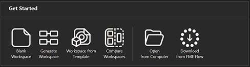
A Beginner’s Guide to Creating an Address Workflow in FME™ Workbench


By Jacob Blankenship, GISP, FME-CP, and Al Karlin, Ph.D., CMS-l, GISP

This month, we have a guest contributor, Jacob Blankenship, a Senior Geospatial Analyst with Dewberry introducing a new (to this column) piece of GIS software, FME™ to the column. As always, this column is not an endorsement of the software, but some tips on its implementation in a GIS environment. FME™ is a powerful data integration and transformation tool developed by Safe Software™. It is widely used in GIS, data automation, and ETL (Extract, Transform, Load) workflows to manipulate spatial and non-spatial data efficiently.

Signatures


Geo Week 2025 Recap, Future Student Opportunities, and New ASPRS Leadership!

  • Geo Week is the premier event for geospatial and built world innovations. The conference is held every year in Denver, Colorado and provides excellent opportunities for students to engage with leaders in the geospatial industry. Learn more at: https://www.geo-week.com/.
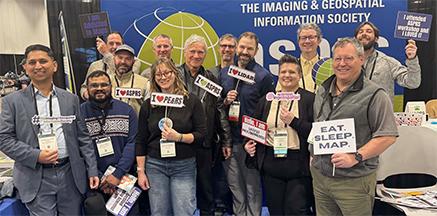
  • Our new ASPRS Leadership was sworn in at Geo Week! Nancee Uniyal (pictured in the middle), a PhD student at the University of Georgia, will be stepping in as the new Student Advisory Council Chair. Nancee is eager to be a part of ASPRS leadership!
  • Each year ASPRS Students can showcase their research in the form of a poster or presentation in the Academic Hub. See abstracts from the 2025 Geo Week Academic Hub here: https://www.geo-week.com/academic-hub/
  • Make sure to stay involved with your ASPRS region and the SAC community to connect at Geo Week! The conference presents many opportunities for students interested in pursuing careers in photogrammetry, geomatics, remote sensing, surveying, and more!
  • Students from San Diego State University representing ASPRS! Make sure to take advantage of on-campus funds as well as ASPRS Scholarships to attend the conference. Learn more about ASPRS Scholarship opportunities: https://www.asprs.org/awards-and-scholarships/summary-of-awards-scholarships.html
  • The Geo Empower Event Scholarship aims to empower and support university students passionate about utilizing geospatial, surveying, mapping, and 3D technology for social good and strives to create an inclusive, diverse, and accepting community of professionals. Through this event scholarship program, we seek to foster innovation, in-person knowledge exchange, and access to mentoring and networking opportunities within geospatial fields and the application of geospatial technologies for positive societal impact. The Event Scholarship is dedicated to increasing diversity in leadership roles within the geospatial and 3D communities. The deadline is typically in the Fall (October-November). Stay up to date here: https://www.geo-week.com/geo-empower-scholarship/

Yearbook


Geo Week 2025 brought together a record-breaking 3,600 geospatial and mapping professionals, representing 49 countries to explore how data, maps, and advanced technologies can deepen our understanding of the world and inform solutions for complex challenges. Geo Week was also the host location to celebrate World Lidar Day, a global holiday to recognize world-wide achievements in lidar.

Announcements

Call for Papers


Special Issue on Hyperspectral Remote Sensing (imaging spectroscopy) to make Gigantic Leaps in Land and Water Science


Guest Editors: Dr. Prasad S. Thenkabail, Dr. Itiya Aneece, Dr. Pardhasaradhi Teluguntla

U.S. Geological Survey (USGS)

Email: pthenkabail@usgs.gov, ianeece@usgs.gov, pteluguntla@usgs.gov


Deadline for submission of manuscripts: rolling submission starting now until July 31, 2026


Tentative publication date: Expect multiple issues in 2025 and 2026


Hyperspectral remote sensing or HRS (imaging spectroscopy) changes the very paradigm of remote sensing data acquisition and, as a result, remote sensing science. HRS sensors typically acquire data in hundreds or thousands of near-continuous hyperspectral narrowbands (HNBs). In contrast, multispectral broadbands (MBBs) such as Landsats, Sentinels, and PlanetScope Doves and SuperDoves acquire data in a few broad spectral bands. HNBs are typically ≥15 nanometers in bandwidth whereas multispectral broad bands (MBBs) are typically >15 nm in bandwidth. However, many spectroradiometers have bandwidth as narrow as 1 nm. HRS data have hundreds or thousands of HNBs along the electromagnetic spectrum (e.g., 400-2500 nm) whereas multispectral sensors have around 10 MBBs in 400-2500 nm. Hyperspectral data can be considered as “signatures” whereas multispectral data are acquired in “a few data points along the spectrum”. Currently, we are acquiring remotely sensed data in four distinct modes. These are defined below (defining characteristic for each type is highlighted in italic bold):


Hyperspatial broadband (HBB) data: (a) Spectral resolution (band width): >15 nm (typically >30 nm), (b) Number of bands in 400-2500 nm: 4-10, (c) spatial resolution: sub-meter to 5 m, (d) radiometric resolution: 8 to 12 bits, (e) temporal resolution: 1-20 days.


Multispectral broadband (MBB) data: (a) Spectral resolution (band width): >15 nm (typically >30 nm), (b) Number of bands in 400-2500 nm: 4-10, (c) spatial resolution: sub-meter to 1000 m (typically 30 m or better), (d) radiometric resolution: 8 to 12 bits, (e) temporal resolution: 5-16 days.


Superspectral broadband (SBB) data: (a) Spectral resolution (band width): >15 nm (typically >30 nm), (b) Number of bands in 400-2500 nm: around 20 optimal bands (Landsat Next has 26 bands in 400-12,000 nm with 21 bands in 4000-2500 nm range), (c) spatial resolution: typically 30 m or better, (d) radiometric resolution: 8 to 12 bits, (e) temporal resolution: 5-16 days.

Hyperspectral narrowband (HNB) data: (a) Spectral resolution (band width): <15 nm (typically <30 nm), (b) Number of bands in 400-2500 nm: 200+, (c) spatial resolution: 30 m, (d) radiometric resolution: 8 to 12 bits, (e) temporal resolution: 1-20 days.


Great advances are taking place in remote sensing science and in particular hyperspectral remote sensing with a suite of new generation spaceborne hyperspectral sensors such as:


Planet Lab’s Tanager-1 acquiring data in 420 hyperspectral narrow bands (HNBs) over 400-2500 nm spectral range in 5 nm bandwidths,


German Space Agency’s DESIS (DLR Earth Sensing Imaging Spectrometer) onboard the International Space Station (ISS) acquiring data in 235 hyperspectral narrow bands (HNBs) over 400-1000 nm spectral range in 2.55 to 10 nm bandwidths,


German Space Agency’s EnMAP (Environmental Mapping and Analysis Program) acquiring data in 222 HNBs over 400-2500 nm spectral range and 10 nm bandwidth,


Italian Space Agency’s PRISMA (PRecursore IperSpettrale della Missione Applicativa, Hyperspectral PRecursor of the Application Mission) acquiring data in 238 HNBs over 400-2500 nm spectral range and 10 to 12 nm bandwidth.


NASA’s Earth Surface Mineral Dust Source Investigation (EMIT) acquiring data in 285 HNBs over 380-2500 nm spectral range and 7.4 nm bandwidth.


Other novel ground-based and drone-borne hyperspectral sensors.

Given the above fact, the overarching goal of the special issue(s) will be to critically evaluate hyperspectral narrowband (HNB) data and establish their challenges, strengths, and limitations relative to other types of remotely sensed data such as the HBB, MBB, and SBB data to advance remote sensing science in the study of Earth’s land and water resources. Specific manuscripts of interest will be as follows:


Characterizing, harmonizing, standardizing, calibrating and comparing: Studying distinct remote sensing data types such as hyperspatial broadband (HBB), multispectral broadband (MBB), superspectral broadband (SBB), and hyperspectral narrowband (HNB) in the study of land and water resources. However, there are no restrictions in use of other data types such as SAR or LiDAR to integrate those data as well as other data such as MBB, HBB, SBB data types with HNB data to enhance information.


Data redundancy and Hughes’ phenomenon: Addressing issues of data redundancy and overcoming Hughes’ phenomenon in hyperspectral data.


Data mining: Exploring data mining methods and approaches to best utilize hyperspectral data.


Spectral libraries: Generating hyperspectral spectral libraries of agricultural crops and vegetation.


Hyperspectral Vegetation Indices (HVIs): Establishing specific hyperspectral vegetation indices (HVIs) to study specific land and water characteristics.


Modeling and mapping: Developing agricultural crop biophysical, biochemical, plant health, plant stress, and plant structural quantity models and maps using HNB and HVI data and comparing the same with HBB, MBB, and SBB data.


Data analysis philosophies: Discussing full spectral analysis (FSA) versus optimal hyperspectral narrowbands (OHNBs).


ML/AI: Implementing machine learning (ML) and artificial intelligence (AI) methods and approaches, especially on the cloud platforms such as Google Earth Engine (GEE), Amazon Web Services (AWS), Microsoft Azure, and high-power computing (HPC).


Other innovations: in methods, techniques, approaches, and a wide array of science applications pertaining to land and water.


All submissions will be peer-reviewed in line with PE&RS policy. Because of page limits, not all submissions recommended for acceptance by the review panel may be included in the special issue. Under this circumstance, the guest editors will select the most relevant papers for inclusion in the special issue. Authors must prepare manuscripts according to the PE&RS Instructions to Authors, published in each issue of PE&RS and also available on the ASPRS website at Instructions to Authors.


Important Dates: Manuscripts due: rolling submissions starting now through July 31, 2026. When we have 5 or more accepted papers, we will publish a special issue. So, if you have a relevant manuscript ready, you can submit right now and submissions with be accepted until July 31, 2026. Please submit your manuscript at https://www.editorialmanager.com/asprs-pers/ and select “Hyperspectral Remote Sensing.”


Guest Editors:


Dr. Prasad S. Thenkabail, PhD


U.S. Geological Survey


Flagstaff, AZ 86001, USA

Email\s: pthenkabail@usgs.gov;

thenkabail@gmail.com


Dr. Itiya Aneece


U.S. Geological Survey


Flagstaff, AZ 86001, USA

Email: ianeece@usgs.gov


Dr. Pardhasaradhi Teluguntla


U.S. Geological Survey

Flagstaff, AZ 86001, USA

Email: pteluguntla@usgs.gov

Peer Reviewed Papers


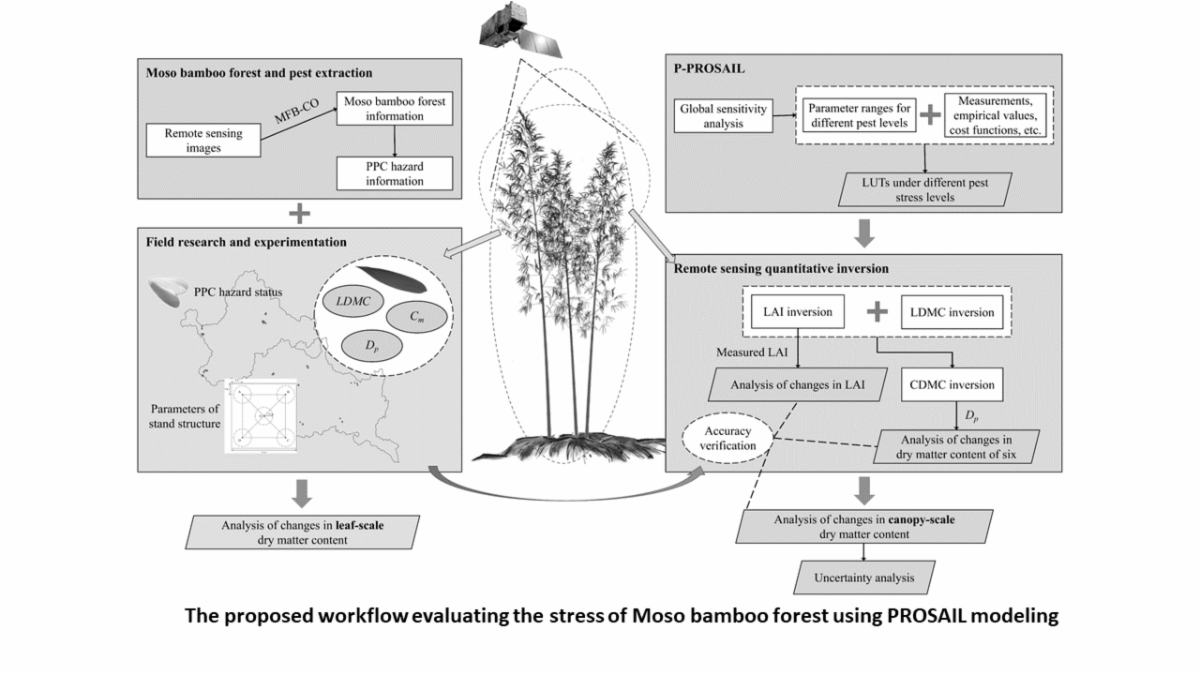
PROSAIL Modeling Coupled with Environmental Stress: Remote Sensing Retrieval of Multiple Dry Matters in the Canopy of Moso Bamboo Forests under the Stress of Pantana phyllostachysae Chao

Zhanghua Xu, Lei Sun, Yiwei Zhang, Huafeng Zhang, Hongbin Zhang, Fengying Guan, Haitao Li, Yuanyao Yang, and Chaofei Zhang

To address gaps in understanding how external stresses influence remote-sensing inversion of vegetation biochemical components, a P-PROSAIL model incorporating stress factors was developed, with Shunchang County and Yanping District in Fujian Province as the study areas. This study clarified the internal and external change characteristics and mechanisms of Moso bamboo forests under Pantana phyllostachysae stress, providing empirical support for the ecological health of bamboo forests.

Wave Period and Direction Inversion from Marine X-band Radar Images using Spatiotemporal Feature Joint Learning

Li Wang, Hui Mei, Na Yang, Caiyun She, and Jian Qu

This paper presents a novel artificial intelligence framework based on a spatiotemporal feature joint learning network aimed at constructing a trainable end-to-end intelligent model for ocean wave period and direction inversion, effectively addressing issues inherent in traditional spectral analysis methods. The spatiotemporal feature joint learning network model proficiently integrates spatial and temporal information of waves and directly maps the obtained results to wave period and direction. The efficacy of the proposed model is validated through application to both simulation data and actual field test data.

Improving Crop Classification by Integrating Phenology Using Random Forests: Assessing the Role of Feature Selection

Hu Jiangwei, Shi Jingye, Liu Jiqiang, Guo Guolong, and Jin Jiadong

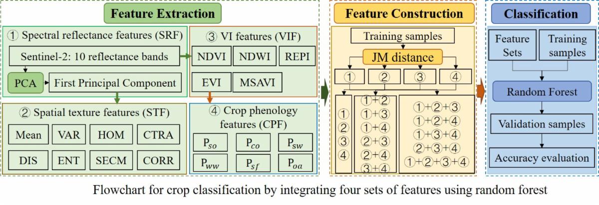
The increase of satellite images with high spatial resolution, short revisit period, and wide spatial coverage has brought an enormous amount of data; however, limited efforts have been made in feature selection for crop classification. Furthermore, different crop types have unique spectral, spatial, and phenological characteristics that have not been well understood and fully used for the expected results. This study established a crop-classification framework using the random forest model by integrating four types of features (i.e., spectral reflectance features, vegetation index features, spatial texture features, and crop phenological features) over 15 scenarios generated from Sentinel-2 images. 

Facebook  LinkedIn  Instagram  X

ASPRS www.asprs.org