Missouri River Basin DEWS News | | | | |
National Integrated Drought Information System
Drought.gov
| | |
February 19, 2026
Plains Snowpack Hits Historic Lows
| | |
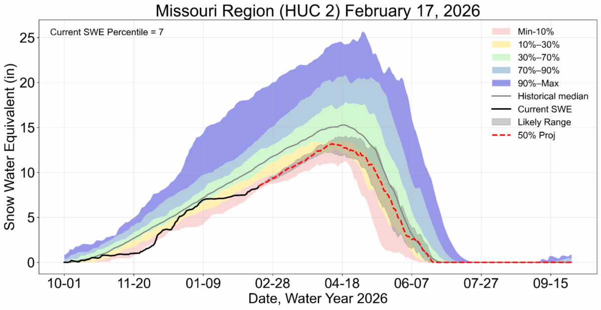
As of February 17, many SNOTEL stations across the mountains of Montana, Wyoming, and Colorado are experiencing the lowest or 2nd lowest snow water equivalent (SWE) on record. SWE, the amount of liquid water stored in snowpack, melts and provides the water many critical economic sectors rely on. SWE in the mountain snowpack across the Missouri River Basin is among the lowest 7% of values on record. Projections, based on historical data, show peak SWE may reach only 10-30% of normal.
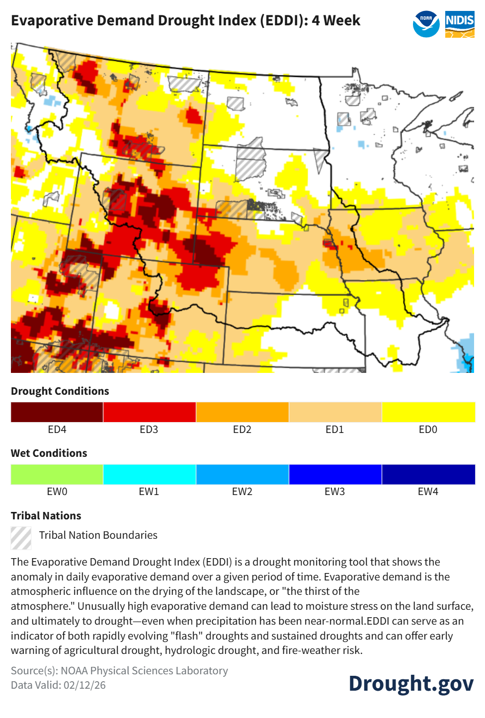
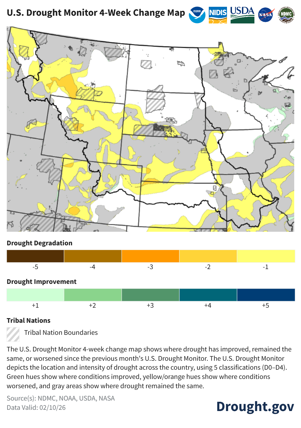
Across the Plains, the last month was warm and dry. Temperatures were much-above-normal, with many states experiencing less than 50% of normal precipitation. As a result of these conditions, high evaporative demand (the thirst of the atmosphere) led to unseasonable drying down of the landscape across large portions of the plains from Montana, Wyoming, Colorado, and western Nebraska. These conditions resulted in historic and near-historic lows of Plains snowpack. Almost all of the Plains snowpack has melted. Runoff and subsequent streamflow forecasts for the Basin predict below-normal conditions due to early snow melt and much-below-normal mountain and plains snowpack. The U.S. Drought Monitor four-week change map depicts drought persistence, development and deterioration across parts of the Missouri River Basin.
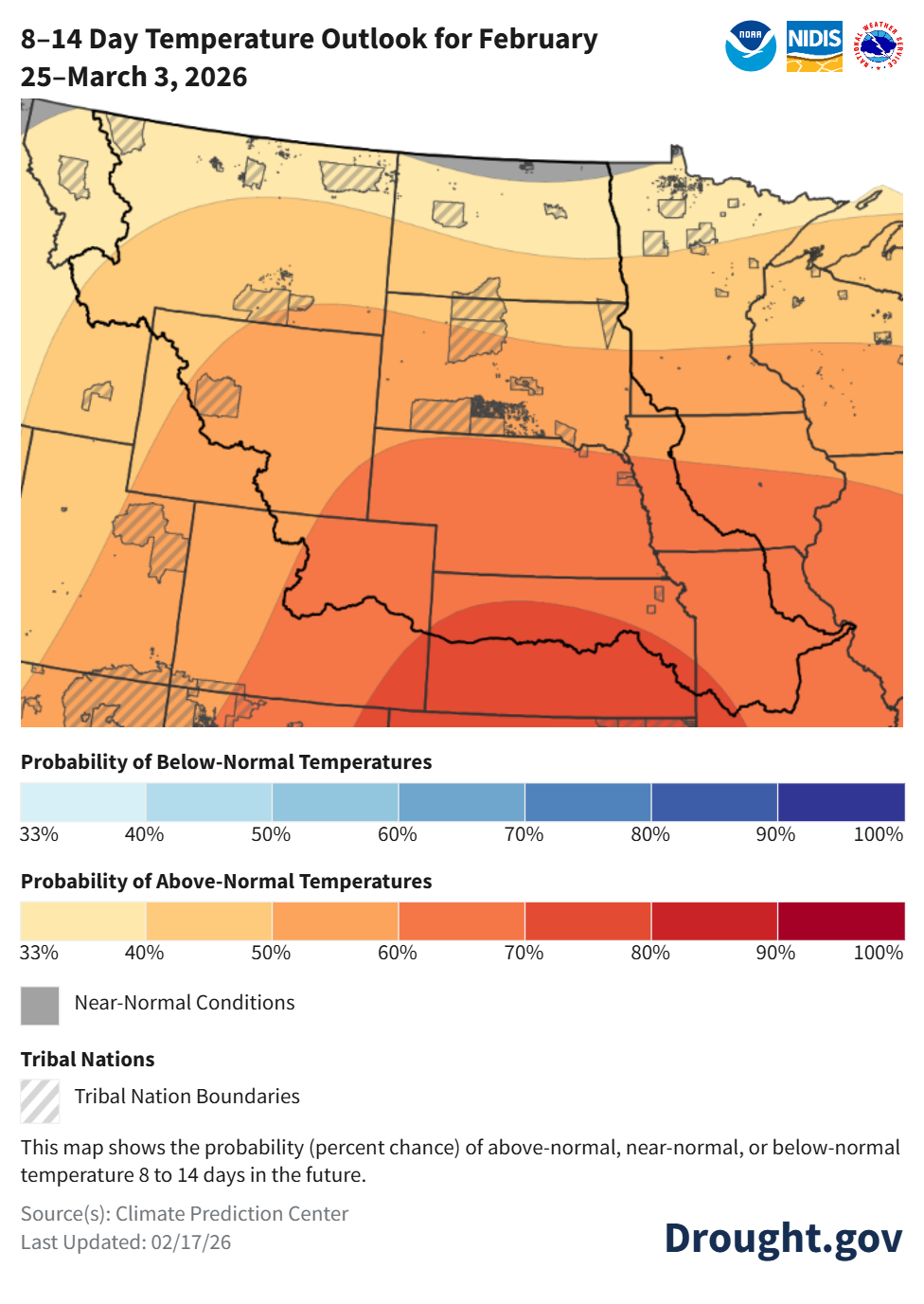
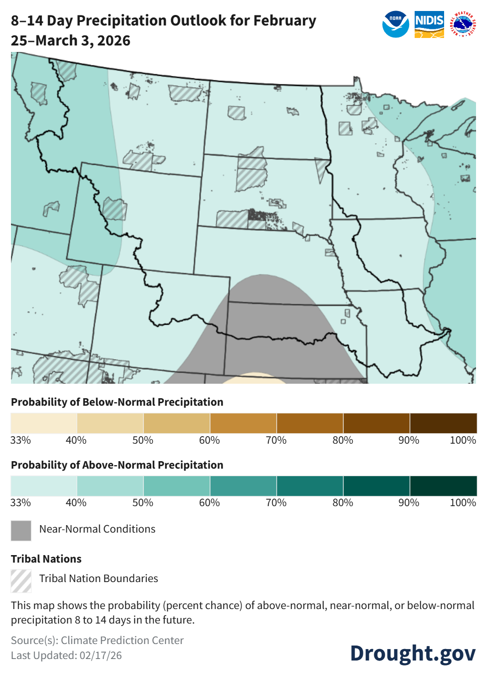
| | The 8-14 day outlooks indicate a greater chance for above-normal precipitation and temperatures across the entire Missouri River Basin, which would be welcome moisture for the region, but could further limit snowpack development. | | |
As conditions evolve, accurate reports on conditions and drought impacts are critical to accurately assess what parts of the region are in drought and what parts are not. Whether your area is currently wet, close to normal, or dry, consider reporting conditions and drought impacts via the Condition Monitoring Observer Reports (CMOR) from the National Drought Mitigation Center. If you are already a CoCoRaHS observer, we encourage you to submit a Condition Monitoring Report.
| | Upcoming Events & Resources | | Flood Risk Low Due to Low Snowpack | | The National Weather Service National Water Center recently released the 2026 Spring Flood Outlook for the Missouri River Basin. This Storymap provides an outlook of spring flooding potential across tributaries of the Mississippi River like the Missouri River. Flood risk through spring is slightly above normal for portions of the Upper Great Lakes, but remains near to below normal elsewhere across the Greater Mississippi River Basin. The lack of Plains snowpack resulted in below-normal flood risk across most of the Missouri River Basin. Looking forward, forecasted precipitation and temperatures are not predicted to significantly alter spring flood outlooks. Learn more > | |
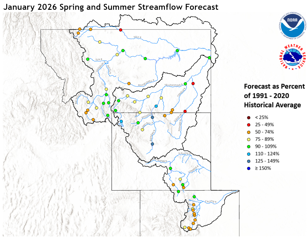
Thin Snowpack Signals Below-Normal Streamflow | |
The Missouri River Basin River Forecast Center released spring and summer streamflow forecasts for the Upper Missouri River Basin, including forecasts for the Upper Missouri River, Yellowstone, and Platte Basins. Forecasts across all basins are below normal due to warm and dry conditions and below normal snowpack. View the January update. The February update will be available at the same link when it is released. The National Weather Service Western Supply webpage also provides the latest streamflow forecast for the Missouri River Basin. Learn more >
| | Below-Normal Runoff Forecasted in 2026 Due to Snow Drought Across the Basin | | |
Despite above-average January runoff, 2026 total runoff is expected to be below average. Early snowmelt, driven by warm and dry conditions, pushed runoff above average in January. The 2026 runoff forecast above Sioux City is 23.4 million acre feet, which is 91% of average. This forecast is based on current soil moisture conditions, plains snowpack, mountain snowpack, and long-term precipitation and temperature outlooks. Forecasts will change as conditions develop.
Learn more >
| | Forwarded This Email? Subscribe for Updates | Subscribe to the National Integrated Drought Information System's Missouri River Basin DEWS list to receive drought status updates, webinars, and other drought news for the Missouri River Basin DEWS. Or, subscribe to NIDIS's bi-weekly newsletter, Dry Times, to receive national news, drought research, and events. | | The Missouri River Basin DEWS is a collaborative federal, regional, state, and local interagency effort to improve drought early warning capacity and build long-term drought resilience throughout the region. The Missouri River Basin DEWS currently includes Montana, Wyoming, Colorado, North Dakota, South Dakota, Nebraska, Kansas, and Missouri. NIDIS is an interagency program within the Climate Program Office, which is part of NOAA's Office of Oceanic and Atmospheric Research. | | | | |