|
Hello there!
In this issue, we are revisiting some of our favorite highlights from 2024.
| | |
|
|
Bringing NASA Technology to Farmers: Highlights from Our Conversation with the Director of NASA's Earth Science Division
Dr. Karen St. Germain, Director of NASA’s Earth Science Division, joined us for a two-part video series on how NASA’s satellite technology is driving innovation and sustainability in agriculture.
| | |
|
|
Satellite Insights Drive Smarter Cover Crop Management and Environmental Outcomes
NASA Acres scientists with the U.S. Geological Survey (USGS), USDA Agricultural Research Service (ARS), and the Maryland Department of Agriculture are advancing Earth observation-based methods to monitor climate-smart practices like winter cover crops. Their work is helping model the impact of these practices on soil erosion and other critical environmental outcomes.
| | |
|
|
Connecting American Farmers to Satellite Solutions at 2024 Commodity Classic
Last spring, we traveled to Houston, Texas with NASA's Agriculture Program for the nation’s largest farming conference, Commodity Classic, to connect with farmers from across the country. At the NASA booth, we provided educational materials and hosted expert speakers on key topics such as farmer data governance, artificial intelligence, soil health, and climate change.
| | |
|
|
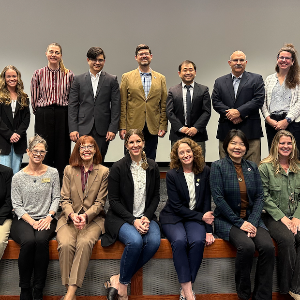
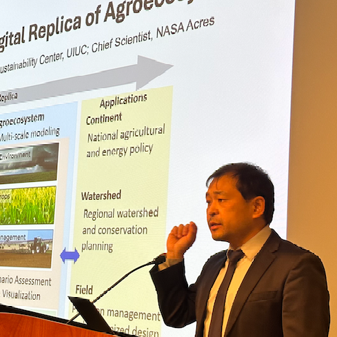
NASA Space for Ag Tour Touches Down in Champaign, Illinois
Dr. Kaiyu Guan, Chief Scientist of NASA Acres, welcomed leadership from NASA Acres and the Earth Science Division to his home base at the University of Illinois Urbana-Champaign. The visit provided an opportunity to tour research sites, meet end users, celebrate the program’s first-year achievements, and align on objectives and opportunities for future collaboration.
| | |
|
|
Eight Early-Career Scientists with NASA DEVELOP Explore Use Cases of Satellite EO for Rangelands
This past spring, eight early-career professionals from the NASA DEVELOP Program joined the NASA Acres team at Colorado State University (CSU) for 10-week feasibility studies focused on applying satellite Earth observations (EO) to rangeland and ranch management. Their projects explored the impact of night penning on vegetation and evaluated satellite-derived net primary production models over rangelands.
| | |
|
|
John Deere's the Furrow Meets with NASA Acres to Discuss How Advancements in Satellites are Pushing the Boundaries for What's Possible with Farming.
Satellites have long delivered beautiful maps and interesting information, but the data hasn't always been overly practical or useful for farmers or scientists, says Kaiyu Guan, University of Illinois earth systems scientist. "Progress in the recent decade is taking satellite data beyond to provide important variables people can use to actually optimize the management of their land for productivity and environmental outcomes."
| | |
|
|
Survey Highlights Farmers’ Belief in Data Ownership and Collaborative Data Use
Earlier this year, NASA Acres partnered with Farm Journal’s Trust In Food Initiative, with input from Ag Data Transparent, to survey farmers on their experiences with ag data collection and use. More than 1,000 farmers shared their perspectives, here are some key insights:
-
Farmers overwhelmingly believe they own their data but are less certain about who has access to it and how it is stored.
-
Many farmers want help using their data more effectively, yet only a third know where to turn for support.
-
Concerns around data privacy remain high, with fears about losing control once data is shared or it being misused against them.
| | |
|
|
Next Stop on the Space for Agriculture Tour: New York's Finger Lakes Region
In August, NASA leadership visited Cornell research sites across New York’s Finger Lakes region including Cornell’s main campus, Cornell AgriTech, sites in Niagara county and the Cornell Lake Erie Research and Extension Lab in Portland, New York. These site visits were a part of a three-day “Space for Ag Tour” by NASA leaders to better understand the remote sensing needs of Cornell AgriTech researchers, specialty crop growers and local stakeholders.
| | |
|
|
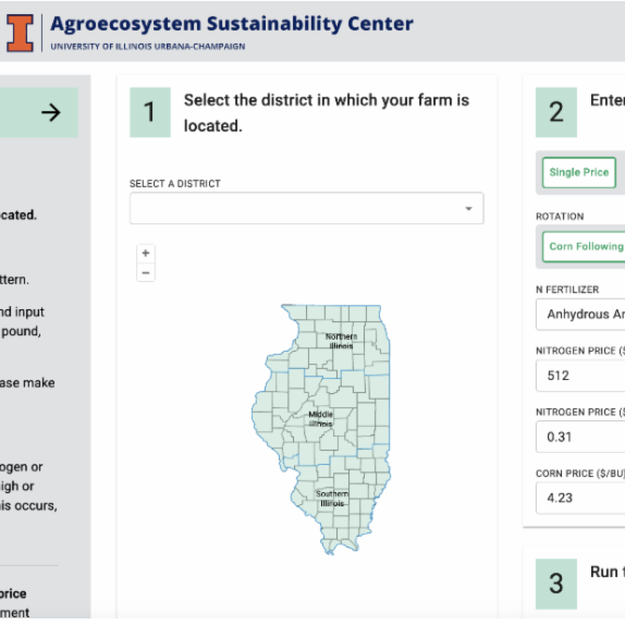
UIUC Researchers Launch Data-Driven Tool to Help Illinois Farmers Optimize Fertilizer Use
Researchers at University of Illinois, led by Kaiyu Guan, Chief Scientist of NASA Acres, have developed a tool to help Illinois corn farmers optimize nitrogen (N) fertilizer use. The Maximum Return To Nitrogen (MRTN) Tool uses data on N fertilizer response and prices to help farmers apply only what’s needed, improving returns and reducing environmental impact.
| | |
|
|
Acres of Potential: How NASA Acres Works to Bring Satellite Imagery to Agriculture
NASA Acres Deputy Director, Dr. Mike Humber, joined for an episode of the On Orbit podcast to discuss how we’re bridging gaps, building trust, and driving the adoption of satellite imagery to support the agriculture industry.
| | |
|
|
NASA Acres and NASA Harvest Highlight Satellite & Ag Innovations at AGU Annual Meeting
NASA Acres and our sister Consortium, NASA Harvest, had a packed week at AGU’s Annual Meeting. Together, we convened a poster session and three oral sessions under the theme “Satellite Solutions: Advancing Agricultural Monitoring Through Remote Sensing.” These sessions showcased new findings, methods, data sources, and challenges across scales and geographies related to the use of Earth observations for agriculture and food security.
| |
Some Of Our Other Favorite Highlights From 2024 | | |
|
|
NASA and Cornell use Robots, Satellites for Agricultural Research
Robots are helping us better detect diseases in specialty crops. In this case, grapes, and the the downy mildew that’s part of a test plot near the campus research facility. The robots are part of a unique program that pairs the agriculture industry, researchers and NASA. Last year, Cornell received a $1.4 million dollar grant as part of an effort called NASA Acres, to expand the use of satellite imagery coupled with ground research to eventually assist growers.
| | |
|
|
NASA is Helping Farmers — How Researchers Are Using Satellite Images to Address Big Ag Issues
It’s been a year since NASA kicked off an effort to provide farmers with useful information garnered from satellite images of Earth. “We want to hear what producers need,” said Tom Wagner, associate director of NASA Earth Action. “We want to build the tools to address their challenges.” Wagner spoke at an event at the University of Illinois, marking NASA Acres' one-year anniversary. The university is one of 10 involved in the consortium’s 14 research projects, which will convert the data NASA gathers into information that farmers can use.
| | |
|
|
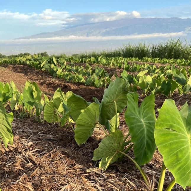
ASU Team Launches Maui Nui Crop Monitor Newsletter to Provide Farm-Specific Insights to Farmers on Maui, Hawaii
Earlier this year, the ASU team, led by Dr. Hannah Kerner, launched the Maui Nui Crop Monitor newsletter. This publication provides timely updates on crop conditions across Maui County, delivering farm-specific insights to select farmers using AGMET data to inform irrigation and management decisions.
| | | | |