|
Good morning,
Rainfall and Flash Flooding This Week
Isolated showers and thunderstorms remain likely across the mountains for the remainder of the week before drier conditions return for next week.
- A Marginal Risk (level 1 of 4) for isolated flash floods is in place across the mountains and portions of the NC coast on Wednesday.
- Showers and thunderstorms in the mountains will be slow moving, increasing the potential for locally heavy rainfall rates.
- Outer rainbands from Hurricane Erin may make their way onshore Wednesday night into Thursday across portions of eastern NC. Heavy rainfall coupled with coastal flooding will enhance the concern for flooding along the NC coast.
- The potential for isolated flash flooding continues in portions of the mountains through the remainder of the week where a typical summertime pattern of showers and thunderstorms will continue.
- Drier conditions will return statewide Sunday into next week.
Tropical Weather Update
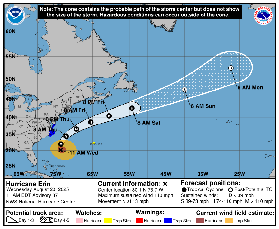
Hurricane Erin is located 365 miles south-southeast of Cape Hatteras, NC and will remain offshore while making its closest approach to NC Wednesday night into Thursday morning. Hazardous marine and coastal conditions will continue to deteriorate through the day Wednesday with the greatest impacts expected Wednesday night into Thursday morning. Hazardous marine and coastal conditions will continue into late week.
- Erin currently has maximum sustained winds of 110 mph with some strengthening possible over the next couple of days. The system is moving north near 13 miles per hour and is forecast to turn north-northeast by Wednesday night while also increasing in forward speed.
- Tropical storm force winds extend approximately 265 miles from the center of the storm. The storm is also expected to undergo additional increases in size. While the center of Hurricane Erin will remain well offshore, this large size will bring impacts to the NC coast, especially the Outer Banks.
- Conditions along the NC coast will worsen through the day Wednesday with the most significant impacts expected Wednesday evening into Thursday morning. However, hazardous conditions are forecast to continue through late week.
- Impacts to the NC coast include extremely rough marine and damaging coastal conditions, tropical storm force winds, and heavy rainfall associated with outer rainbands.
- Higher than normal astronomical tides will increase flooding and marine hazards. The highest high tide is expected Thursday evening and elevated tides will continue into the weekend before slowly returning to normal.
- A Storm Surge Warning is in effect from Cape Lookout to Duck, NC where the greatest surge (up to 4 ft AGL) is possible. A Coastal Flood Warning/Advisory remains in effect for coastal Carteret and Onslow Counties, Pamlico and Southern Craven through Thursday evening where inundation of 1-4 ft remains possible. A Coastal Flood Watch is in effect for eastern Currituck from Thursday PM through Friday PM where inundation of 1-3 ft is possible.
- Soundside flooding is possible for downeast Carteret County as well as Hatteras and Ocracoke Islands Wednesday evening into Thursday morning as the system moves NE away from the NC coast. Additionally, coastal flooding will remain possible for Currituck County Thursday into Friday.
- Coastal flooding from ocean overwash has already begun across Hwy 12 on Hatteras Island, but will peak Wednesday into Thursday across the Outer Banks, tapering off Friday. Numerous roadways will likely be impassable, possibly for several days, especially in low lying areas and along Hwy 12 across the Outer Banks.
- Strong, long period waves up to 15-20+ ft are forecast along much of the central coast with up to 10-14ft waves along southern and northeastern beaches. Extensive beach erosion, major coastal flooding and ocean overwash are likely, peaking late Wednesday through Thursday.
- A Tropical Storm Warning is in effect from Beaufort Inlet, NC to the NC/VA border, including the Pamlico and Albermarle sounds. Sustained winds of 30-40 mph and wind gusts of 50-55 mph are possible within the warning area, peaking late Wednesday through Thursday.
In addition to Hurricane Erin, the National Hurricane Center is currently monitoring two areas of interest in the tropical Atlantic.
- A tropical wave located over the central tropical Atlantic continues to produce disorganized showers and thunderstorms. Environmental conditions appear favorable for gradual development, and a tropical depression could form later this week or weekend while it moves near or to the north of the northern Leeward Islands. There is a medium (60%) chance of development within the next 7 days.
- A tropical wave located to the SW of the Cabo Verde Islands continues to produce a concentrated area of showers and thunderstorms. Environmental conditions appear marginally favorable for additional development over the next day or so while the system moves westward around 15 mph. A short-lived tropical depression could form, but by the end of the week conditions are expected to become unfavorable for further development. This system has a medium (40%) chance of development within the next 7 days.
Please let me know if you have any questions.
|