|
Good morning,
Well below normal temperatures will continue through the work week and into the weekend, where any lingering moisture remaining on roadways will re-freeze each night. The likelihood of a major winter storm is increasing with widespread 60-95% chance of major impacts possible across the Piedmont and Coastal Plain by Sunday afternoon, and 20-50% chance of extreme impacts across the eastern Piedmont and Coastal Plain. Remain weather aware through the work week as forecast details continue to be refined. Now is the time to ensure your emergency preparedness kit is stocked and ready for any power outages.
- A Winter Storm Watch will go into effect for all of NC from Friday afternoon (or early overnight across the east) through Sunday afternoon where heavy snowfall with locally significant snowfall is possible. Hazardous weather and driving conditions are likely through the weekend. Strong winds may also lead to blowing snow reducing visibility and could bring down tree limbs and cause power outages.
- A Cold Weather Advisory is in effect through this morning for portions of eastern NC and the mountains where dangerous wind chills may result in hypothermia or frostbite if precautions are not taken.
- A High Wind Watch is in effect for the Outer Banks from Saturday evening through Sunday afternoon where northern winds of 40-50 mph are expected with wind gusts up to 65 mph.
- Mostly dry conditions are forecast Thursday into Friday. Breezy conditions will continue Thursday with wind gusts up to 15-20 mph. High temperatures will rise to the mid to upper 30s and low 40s today with overnight lows dipping into the teens and 20s.
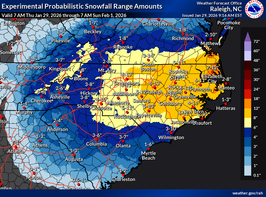
- Confidence continues to increase that a major winter storm will impact much of NC late Friday through Sunday. Light snow is forecast to begin across the mountains Friday afternoon and gradually spread east through Friday evening. Peak snowfall accumulation is forecast late Friday into Saturday across the mountains and Saturday into early Sunday elsewhere. Heavy snowfall rates of 1”-2” per hour is possible, especially across eastern NC. While high uncertainty remains with forecast snowfall amounts, an axis of significant accumulation is possible, especially wherever the heaviest band of precipitation sets up. Snow is expected to end from west to east Saturday afternoon in the mountains into early Sunday morning across the east.
- Widespread snow accumulation of at least 2-4” with 6”+ likely are forecast across central and eastern NC. Significant snowfall amounts up to 10-12”+ are also possible, especially along and east of the I-95 corridor. Snow accumulation of 3-8” is possible across the mountains and Foothills.
- As details become more refined on where the heaviest snowfall may occur, be sure to monitor future weather forecasts for any changes.
- Very windy conditions are also expected with this winter storm over the weekend. Wind gusts up to 25-40 mph are possible Saturday through Sunday, with the strongest gusts up to 55-60 mph across the mountain and Outer Banks. Localized blizzard conditions are possible across portions of the mountains, coastal areas along the Albemarle-Pamlico Peninsula, and Outer Banks.
- Strong winds will likely reduce visibility, result in significant blowing and drifting snow, and lead to isolated power outages and tree damage.
- Avoid travel, if possible, as treacherous travel and white out conditions are likely during this event.
- Strong winds will also lead to moderate and locally significant coastal flooding and ocean overwash along the NC coast. Coastal flooding of 2-4ft inundation AGL is possible for soundside and oceanside areas of the Pamlico Sound and Outer Banks. Travel impacts are likely along vulnerable portions of NC-12, especially Hatteras and Ocracoke Islands.
- A Coastal Flood Watch and High Surf Advisory is likely be needed for most of the state.
- A prolonged period of well-below temperatures is forecast over the weekend and will continue into next week. High temperatures will rise into the 20s and 30s with lows dipping into the single digits and teens across much of NC. Dangerously cold wind chills are likely, with below zero wind chills possible across most of the state Saturday and Sunday nights. A Cold Weather Advisory or Extreme Cold Watch/Warning will likely be needed.
- Cold temperatures may lead to hypothermia or frost bite, so take appropriate precautions. Remember to keep generators outdoors and at least 20 ft. away from entry points to avoid carbon monoxide poisoning.
Please let me know if you have any questions.
|