|
Good morning,
Snowfall is ongoing across much of the state Saturday morning and will continue through the day today. Widespread snowfall is forecast across the state with locally significant snow accumulations expected for portions of eastern NC. Dangerously cold temperatures are forecast to begin today, lingering through Sunday. Strong wind gusts will bring below zero wind chills overnight tonight and moderate to locally significant coastal flooding. Cold temperatures are expected to linger into next week, prolonging snowfall impacts.
- A Winter Storm Warning remains in effect through Sunday morning across the western half of the state, and through Sunday evening across the eastern half of the state. Heavy snowfall and locally significant accumulations are expected statewide. Hazardous weather and driving conditions are likely through the weekend into next week, especially where the heaviest snow accumulates.
- A Cold Weather Advisory is in effect across central and eastern NC until Saturday night where wind chills near zero are forecast.
- An Extreme Cold Warning will go into effect across the mountains this afternoon and will go into effect for the remainder of the state Saturday night where below zero wind chills are forecast for the entire state. Wind chills across the mountains may reach 25F below zero.
- A High Wind Warning and Wind Advisory will go into effect this afternoon and evening across much of the NC coast and inland portions of the Coastal Plain. Wind gusts within the High Wind Warning are forecast to be up to 55-70+ mph and wind gusts within the Wind Advisory are forecast to be up to 40-55 mph.
- A Coastal Flood Warning and Coastal Flood advisory will go into effect this afternoon through Sunday night for portions of the coast where inundation up to 2-4 ft.AGL is forecast.
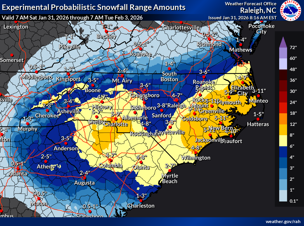
- Ongoing snowfall will continue through Saturday, ending from west to east and pulling out of the region by mid-day Sunday. The greatest snowfall accumulations are forecast Saturday afternoon when heavy snowfall rates of 1-2” per hour are possible, but will be dependent on where the heaviest bands develop. Widespread snowfall accumulations between 3-8” are forecast across the state, especially across the Coastal Plain where the greatest snowfall amounts are most likely. Significant snowfall amounts of 8-12”+ are possible for portions of the state, especially eastern NC where the heaviest snowfall bands are most likely to develop.
- However, localized areas may receive low end snow accumulation totals or less accumulation than forecast if bands do not develop over that location.
- Wind gusts will increase throughout the day today and will linger through the weekend. Wind gusts up to 25-45 mph are possible across central NC Saturday and Sunday, with wind gusts between 55-65 mph across the mountains, and wind gusts 55-70+ mph along the coast. Strong winds will likely create localized blizzard conditions wherever the heaviest snowfall bands set up.
- Wind gusts may be near advisory criteria across the mountains, especially for the highest peaks.
- Strong winds will also reduce visibility from blowing and drifting snow and may lead to scattered power outages and tree damage.
- Avoid travel if possible as treacherous travel and white out conditions are likely throughout the event.
- Strong winds and higher than normal astronomical tides will lead to moderate and locally significant coastal flooding and ocean overwash along the NC coast. Coastal flooding of up to 2-4ft inundation AGL is possible for soundside, adjacent tidal rivers, and oceanside areas of the Pamlico Sound and Outer Banks. Travel impacts are likely along venerable portions of NC-12, especially Hatteras and Ocracoke Islands.
- High temperatures will rise into the 20s and 30s this afternoon, with wind chills in the single digits and teens across much of the state today. Dangerously cold temperatures will continue over the weekend, especially overnight tonight and Sunday night where wind chills are forecast to be below zero across much of the state.
- Below normal temperatures are forecast into early next week. While high temperatures are forecast to be above freezing for much of the state beginning Monday, overnight temperatures will be below freezing. Any moisture that lingers on roadways from snow melt will freeze overnight, prolonging hazardous road conditions into next week.
- Cold temperatures may lead to hypothermia or frost bite, so take appropriate precautions. Remember to keep generators outdoors and at least 20 ft. away from entry points to avoid carbon monoxide poisoning.
Please let me know if you have any questions.
|