|
Good morning,
A very slow-moving cold front will continue to move SSE through the state, eventually stalling over eastern NC late tonight into Friday. Strong to severe storms along with isolated to scattered flash floods remain possible across much of NC Thursday and into the weekend. The axis of heavy rainfall has moved south of the Triad region but is currently moving through the Triangle area and will continue pushing southeastward. While Tropical Storm Bertha moves westward toward Texas, the system will continue to help supply moisture from the Gulf allowing storms to be highly efficient rainfall producers.
- Continuous rounds of showers and storms focused along a slow-moving frontal boundary will continue to impact much of NC Thursday and Thursday night. An additional 2-4” of rainfall, with locally higher amounts of 6”+ will remain possible through Friday afternoon across portions of central and eastern NC. Across southern portions of western NC, widespread rainfall amounts of 1-3” is forecast through Friday night. Localized rainfall amounts up to 5” are possible, especially along the Blue Ridge Escarpment and into the foothills.
- A Flood Watch remains in effect across portions of northern and western NC through Thursday evening and portions of central and eastern NC through Friday morning. A Flood Watch will go into effect across SE NC Thursday evening until Friday afternoon.
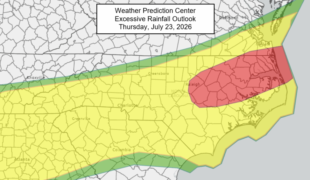
- The greatest risk of numerous flash floods Thursday and Thursday night will be across northern portions of central and eastern NC, including the Triangle region. Isolated to scattered flash floods remain possible elsewhere through Friday morning, with the greatest threat across urban areas. As the cold front settles across coastal NC, the threat of scattered flash floods will continue across portions of central NC and eastern NC Friday and Friday night. Additionally, scattered flash floods will remain possible across the southern mountains through Friday night. The greatest threat of flash flooding will remain along the NC Coast Saturday, although isolated flash floods remain possible into portions of central and western NC.
- Most mainstem rivers are currently forecast to peak near or below minor flood stage, but creeks and streams will rise more rapidly with the forecast rainfall. Any rises on rivers, creeks and streams are expected to peak over the weekend.
- Thunderstorms are ongoing across portions of NC along the frontal boundary and will continue through the day and into tonight. The SPC has introduced a Marginal Risk (level 1 of 5) for isolated severe storms across SE NC on Thursday afternoon and evening, continuing through Friday afternoon. The primary impacts with any severe storms that develop will be damaging wind gusts, but an isolated brief tornado cannot be ruled out across eastern NC on Thursday.
- Tropical Storm Bertha continues in the northern Gulf and has maximum sustained winds near 45 mph. This system will continue moving westward through tonight before turning toward the west-southwest on Friday along the Louisiana and upper Texas coast. Little change in strength is expected today and is forecast to dissipate inland over Texas by tonight or Friday.
- Last week's rainfall brought improvements to Extreme (D3) and Exceptional (D4) Drought conditions cross the Piedmont and northern Coastal Plain. For more information, the latest Drought Monitor Infographic provided by the North Carolina Climate office is included in the attached weather graphics
Please let me know if you have any questions.
|