|
Good morning,
High pressure will remain over the region through much of the week bringing mostly dry conditions, however daily chances of showers and storms can’t be ruled out. Dangerously hot weather is also forecast through much of the week so take precautions to lower your risks of heat related impacts.
- Dangerous heat and humidity will continue through mid-week with highs topping out in the upper 90s to lower 100s. Heat index values of 100-110F+ are possible across much of NC through Wednesday with less intense heat possible through the remainder of the week, however temperatures will remain hot.
- An Extreme Heat Warning is in place for portions of northeast NC from 10AM Monday morning to 8PM Wednesday where dangerously high heat index values up to 112F are expected.
- A Heat Advisory is in effect for much of central and eastern NC from late Monday morning into Tuesday morning where heat index values up to 110F are expected. An upgrade to an Extreme Heat Warning is likely for much of central NC for Tuesday and possible Wednesday as well.
- An Extreme Heat Watch is in effect for portions of central and eastern NC Tuesday morning through Wednesday evening where heat index values of up to 110-113F are possible.
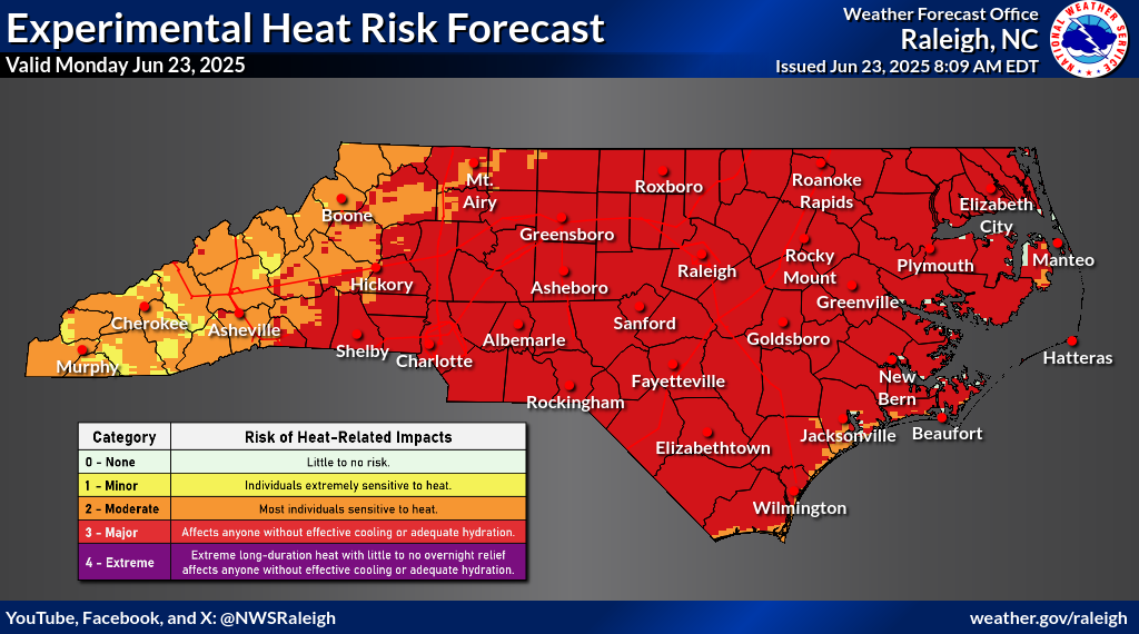
- Due to dangerous heat conditions, a Major Heat Risk develops across much of the state Monday through Wednesday, with an Extreme Heat Risk developing by Tuesday and extending into Wednesday. While less intense heat is possible late week, Moderate to Major Heat Risks will still be possible.
- Major and Extreme Heat Risk will impact anyone without effective cooling and/or adequate hydration, especially with little to no overnight relief.
- If possible, limit time outdoors and be sure to take plenty of breaks and stay hydrated.
- While mostly dry conditions are forecast, isolated to scattered showers and thunderstorms can’t be ruled out each afternoon through mid-week with chances increasing later in the week.
- A Marginal Risk (level 1 of 5) is in place across much of the southern half of NC Wednesday where strong to severe storms will be possible. The primary threat will be damaging wind gust and hail.
- The National Hurricane Center is monitoring an area of interest for potential tropical development with a 70% chance of formation over the next 48hrs. A short-lived Tropical depression may form as soon as today but by Tuesday, the system is expected to encounter less favorable conditions and remain over the open Central Atlantic.
Please let me know if you have any questions.
|