|
Good morning,
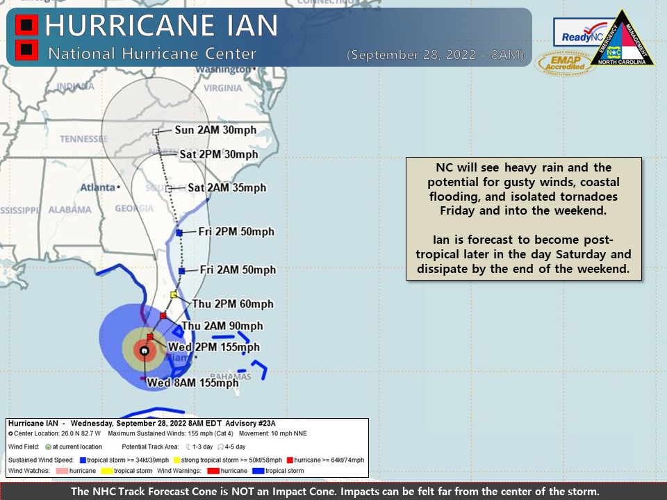
Overall there was very little change to the forecast and expected impacts to NC since yesterday. Heavy rain could result in localized flash flooding, possible landslides along the Blue Ridge Escarpment, and rises on main-stem rivers, but moderate or major river flooding is not anticipated.
Wednesday:
- Partly sunny and dry conditions are expected today, with highs in the 60s and 70s.
Thursday:
- Most areas will remain dry through the day, with rain chances increasing during the evening and overnight hours across southeastern NC. Areas of coastal flooding could develop later in the day Thursday.
- The southern and western Pamlico Sound, Neuse/Bay/Pamlico/Pungo Rivers are most at risk of seeing coastal flooding due to northeasterly and easterly winds. Minor oceanside coastal flooding possible along the southern NC coast and Outer Banks and significant storm surge flooding is expected to remain south of NC.
- A Coastal Flood Watch is in effect from Thursday afternoon through Saturday morning for Beaufort, Pamlico, southern Craven, and eastern Carteret counties as 1-3’ of inundation is possible in low-lying areas near shorelines in tidal waterways.
Friday:
- The heaviest rain and threat of localized flash flooding will spread across the state from east to west during the day Friday and Friday night.
- Gusty winds will also expand across the state, which will become an increasing concern as soils become saturated, leading to an increased chance of downed trees.
- Isolated-brief tornadoes will be possible Friday afternoon and into early Saturday across eastern NC.
Saturday:
- Rain, heavy at times will continue and the threat of flash flooding will likely peak during the day and overnight hours in areas along and near the Blue Ridge Escarpment.
- Heavy rainfall rates could lead to an increased potential of landslides across the mountains.
- Gusty winds will continue with most areas seeing gusts of 25-40 mph. Locally stronger gusts will be possible across the higher elevations of western NC and along the immediate coast.
Sunday – Monday:
- Showers will likely continue on Sunday and possibly Monday, but rainfall rates and coverage will be less than previous days. The greatest flooding threat on Sunday will be along the NC/VA border.
Please let me know if you have any questions. The next NCEM Hazardous Weather Update will be sent by 6PM this evening.
|