May 2023

Water Data Initiative Newsletter

2023 Water Data Workshop Success

A huge thank you to all those who attended the

May 4 Water Data Workshop!


More than 120 people came together on this day at the New Mexico Water Data Workshop at the New Mexico Institute of Mining and Technology in Socorro, New Mexico, to discuss how to harness the potential of water data, tools, and collaboration to address water related challenges. This workshop, hosted by the New Mexico Bureau of Geology and Mineral Resources, served as a platform for local, regional, state, and federal agencies, and community members to learn and explore innovative ways to enhance how we use water data.


The agenda and linked presentations from the workshop are available here.

Read the Workshop Brief here

Water Data Feature:

Village of Corona water data and considering windfarms

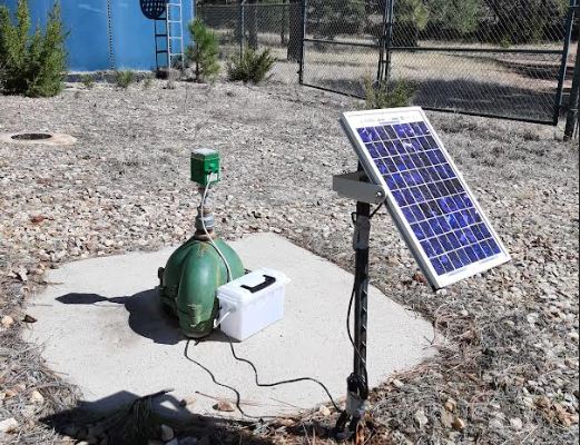
When the Village of Corona joined the New Mexico Bureau of Geology's Healy Collaborative Groundwater Monitoring Network in 2017, they began receiving depth to water measurements collected in the middle of the day and the middle of the night in their municipal supply well. Who could need so much data? What use could it be?


Now, almost six years later, as the village contemplates its water future, the collected measurements provide crucial support in the decision-making process.


Corona is facing serious questions about resource and funding allocation. Wind farms are considering this location for building, but this comes with a water resource cost. The data gathered in this project help provide the village of Corona with the information they need to better understand the context of construction, water resources, and financial benefits.


This is an example of water data being used in real-life decision making!

Read more here

U.S. Bureau of Reclamation:

New Water Data tool -

Water Operations Dashboard

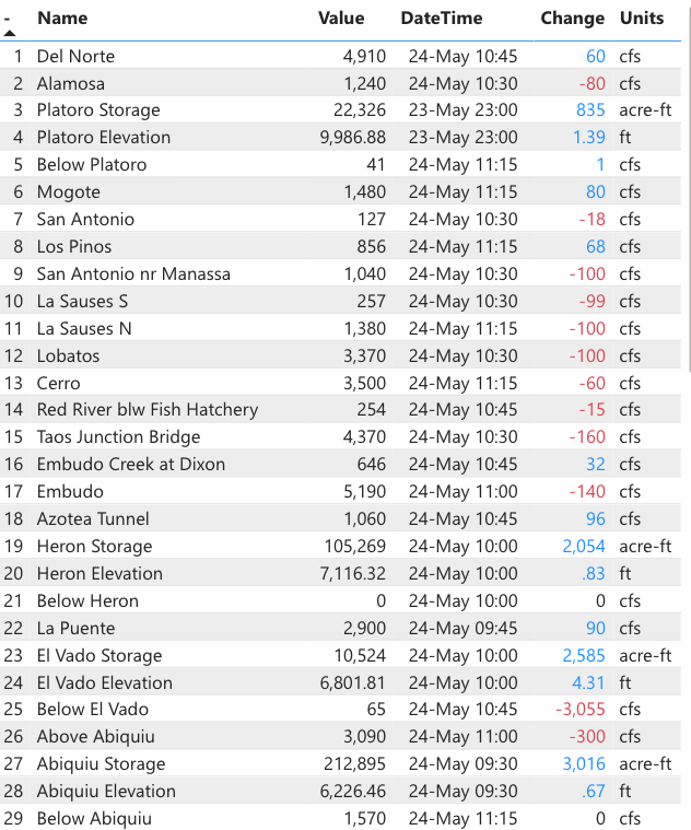
This Rio Grande and Pecos River Water Operations Dashboard was created using the Microsoft Power BI application and is currently available to the public. This dashboard, developed by the Bureau of Reclamation, was created to provide real time data of the Rio Grande and Pecos rivers and reservoirs for water operation managers to assist in monitoring and making decisions. Data includes 15-minute water flow data and reservoir elevation and storage data from the U.S. Geological Survey, Colorado Department of Water Resources, and U.S. Bureau of Reclamation.


The water operations dashboard, developed by Civil Engineer/Hydrologist Lucas Barrett at U.S. Bureau of Reclamation, is in an easy to navigate format that allows the user to clearly view current river and reservoir data at a single website to help make operations, management, and planning decisions.

View the Dashboard Here

Stay up to date with the NM Water Data Initiative on social media!

Facebook  Twitter  Instagram  Linkedin  Youtube  

New Mexico Water Data Initiative

newmexicowaterdata@nmt.edu

newmexicowaterdata.org