|
Today's Story:
On this beautiful autumn morning as I sat, facing east, in my favorite outdoor meditation spot, I cast my gaze upon a nearby burning bush with its fall leaves still intact.
Then my eyes moved to a huge, proud maple tree nearly 200 feet tall with a proportionally wide girth and most of its leaves still summerly verdant.
But, ultimately, the rising sun drew my attention.
At first, I could not see old Sol but only the effect of its warm rays cast upon arboreal colors: vibrant crimson, deep green, golden yellow.
As the sun gradually rose higher in the sky, its rays peeked over an outstretched limb of the maple tree and shone directly into my eyes, causing me to squint and then close my eyelids.
I turned my attention inward in an attempt to sequester my mind from all worldly thoughts. But that was not to be.
After a few minutes, I sensed a lessening of light.
Opening my eyelids again, I saw that the sun was hiding from me as it rose higher and out of sight on the other side of another hefty limb.
Then I questioned my thoughts about Sol. No, it had not risen, nor was it rising. I, also, had not sagged into my chair nor straightened my posture. It was stationary and I motionless.
So, what was giving the appearance – the illusion – of celestial movement?
Earth, of course. Rotating on its polar axis. The ongoing, unfelt day-in, day-out spin of our giant planet.
That thought took me back to a trip to Ecuador in mid-December 2015 at the time of an annual seasonal phenomenon: the winter solstice.
I was at the Quitsato Sundial, the first and only Monument of the Middle of the World, which is exactly on the Equatorial Line: 0° 0’ 0” parallel.
The Quitsato Sundial lies near the city of Cayambe, near the Cayambe Volcano, and next to the Panamericana Highway that runs north and south between Quito and Cuenca.
The sundial is 52 meters in diameter and constructed of medium-gray mosaic stone with contrasting lines of lighter gray stone that mark the position of the sun when Earth reaches and passes through the solstices and equinoxes.
At the center of the sundial is a hollow column, open at the top, ten meters tall, and wide enough for two or three people to stand shoulder-to-shoulder inside, the shadow of which marks the hours of the day.
At noon on the equinoxes, when Sol is directly overhead, this column does not cast a shadow, but it is possible to stand inside and be totally absorbed in sunlight.
At the base of this column, a docent posed this question: “Which way does Earth rotate?”
The answer, spoken by one visitor after much consideration: “The western horizon rises toward the sun as the eastern horizon moves away from the sun and into darkness.”
“Right,” he exclaimed. “Yet, how are maps drawn?”
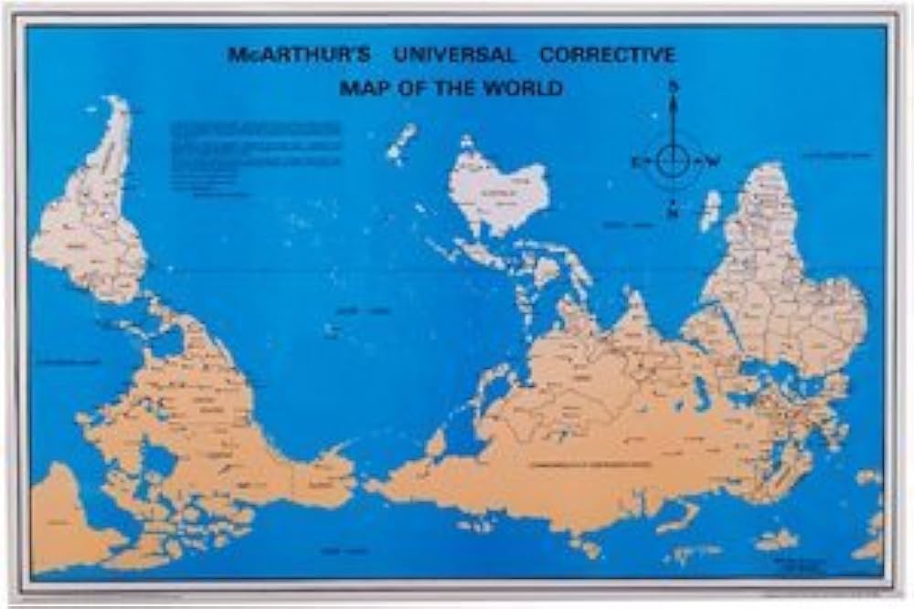
Obvious answer known to all: “With the North Pole at the top and the South Pole at the bottom.”
Why? Why not with West on top to coincide with Earth's rotation?
The website GeoSpatial World says North-on-top maps came into existence in the 16th century with the advent of European imperialism, long voyages across the Atlantic Ocean, and the use of magnetic compasses and the Pole Star as aids to navigation.
As astronomers and navigators with their instruments looked up to the North Star, they also drew their maps with North on top.
The placement of Europe – along with Africa – at the center of the current world map is also a carryover from European colonialism.
But it wasn’t always that way.
When the Chinese invented the compass during the Han Dynasty 200 years before the birth of Christ, they thought its magnetic arrow pointed South, so they drew maps with South on top.
This perception may have been reinforced because northern parts of China were cold and dark and should, thus, be relegated to the lower part of their maps.
Early Egyptian maps also showed South on top, perhaps because the Nile River flows from south to north. With the understanding that rivers flow from higher elevations to lower elevations, they believed that “up” was South.
Mapmakers in Arabia drew maps with South on top because the initial Islamic habitations were north of Mecca. With South on top, hajis would have the impression of journeying “upward” to this holy place.
Other ancient maps were drawn with the top toward East, the direction of the rising sun. This map orientation is supported by multiple geographic passages in the Old Testament.
The website Atlas Obscura says that West-on-top maps are rare, but there have been a few.
A map of the Virginia Territory, drawn by British explorer Captain John Smith in 1612, is one.
Smith may have drawn this map as the land would have appeared to a European ship captain landing on the mid-Atlantic coast, with West being the next forward direction of travel.
Olden British-drawn maps of Ireland and a potential route to China also have West on top.
Anthropologists and historians believe that these maps were oriented to facilitate arrival in lands to be explored and possibly conquered and settled.
Interestingly, placing the direction of travel at the top of a map – regardless of the compass heading – is the default setting on modern electronic GPS devices.
Regardless of how maps were and are drawn, our perspective of Earth should be that it is a sphere, suspended in and traveling through space, orbiting around Sol, and rotating on its axis.
Mother Earth – the Big Blue Marble – is our planetary home, our nest in the sky, our source of life and abundance. She is the provider of our water, food, air, and all that sustains us and enables us to grow.
It is our privilege to love her, care for her, and witness her magnificence in ways large and small.
You can read more about my trip to Ecuador in my book Journey … Ecuador, Switzerland, Nepal, Caribbean Cruise 2016, 2017, 2019, available on Amazon.com.
It is one of my 23 books of international travel and adventure in my Journey … People, Places, & Ponderings series.
Thank you.
Below: A map of the world with South on top. Does it look strange ... or just different?
|