|
|
|
Summer 2017 - In This Issue:
|
|
|
|
|
|
|
|
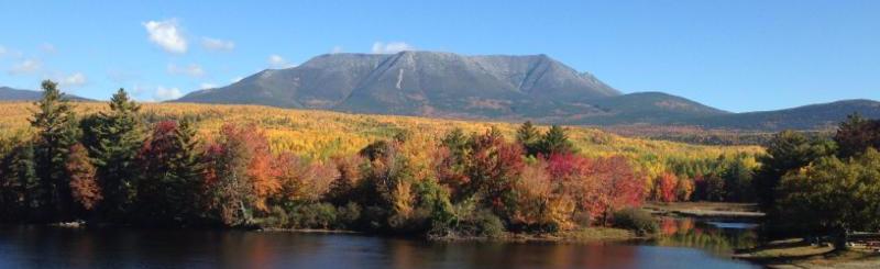
Photo credit: Tamara Lee Pinard, The Nature Conservancy in Maine
|
|
| News from Staying Connected |
As the summer field season winds down and we prepare for fall colors, I am pleased to share this roundup of diverse stories from across the SCI region. As always, it is inspiring to learn about the great work happening on the ground. If we haven't featured your group's work in our newsletter, please be in touch. I welcome your contributions to our future newsletters.
Jessie Levine, SCI Coordinator
|
|
Next Steps for Vermont's Little River Bridge Wildlife Shelf
 |
|
|
Photo credit: Amber Collett, Vermont Natural Resources Council
|
Earlier this week, 17 SCI partners, representing eight different public and private organizations in Vermont, visited the Little River Bridge wildlife shelf project site near Waterbury, Vermont to learn more about the project and identify next steps. The wildlife shelf, built under an existing bridge in 2013 by the Vermont Agency of Transportation and the Vermont Fish and Wildlife Department, passes under two major roads - Highways 89 and Route 2 - and enables wildlife to move between two of Vermont's largest forest blocks in the central and northern Green Mountains. Including this shelf in the larger project of repaving Route 2 only added about $10,000 to the more than $8 million cost of the project. With camera traps and roadside tracking, SCI partners have monitored the site since construction and documented its use by deer, bobcat, and fox. While the shelf's success makes it a model of a cost-effective connectivity enhancement project for transportation agencies, several challenges have arisen at the site, including the need to manage for invasive species and the use of the wildlife shelf by anglers, which may limit its use by wildlife. After seeing first-hand the structure and its success, field trip participants agreed to work together to identify opportunities to conserve the lands between the structure and the large permanently conserved core forest blocks, in order to ensure the long-term viability of the crossing. In addition, they will add two new cameras to the long-term monitoring project underway to gather more data on the interaction of anglers and wildlife at the site. For more information,
contact Jens Hilke
.
|
Conference on Road Ecology and Climate Change Adaptation
On October 23 to 25, join road ecology, connectivity, and climate change adaptation experts from Canada, the U.S., and Europe for the Conference on Road Ecology and Climate Change Adaptation in Quebec City. This meeting will include presentations,
|
|
|
|
workshops, kiosks, and a field trip, all available in French and English, and is for professionals working in road planning, civil engineering, wildlife management, terrestrial and aquatic habitat connectivity, and climate change adaptation, as well as students. The conference is made possible thanks to many partners: Appalachian Corridor (main organizer), Concordia University, Quebec's Ministry of Transports, Mobilité Durable et Électrification des Transports
, Quebec's Ministry of Forêts, Faune et Parcs, Quebec's
Ministry of Développement Durable, Environnement et Parcs, Association des Biologistes du Québec, the Ontario Road Ecology Group, Two Countries, One Forest, Fondation de la Faune du Québec, and ARC Solutions (with Woodcock Foundation). For more information, visit the
conference website
.
|
Identifying Wildlife Crossing Hotspots on Roads in the Berkshires
|
|
|
Photo credit: Andy Wood
|
Andy Wood, a University of Vermont student in the Field Naturalist Graduate Program, just completed a summer research project in the Berkshire Wildlife Linkage. Andy spent the summer measuring culverts, tracking roadkill patterns, and collecting wildlife camera images along western Massachusetts roads. His graduate work is one piece of a larger project with The Nature Conservancy in Massachusetts, Massachusetts Department of Transportation, and other SCI partners, to document wildlife crossings along key roads in the linkage to identify important road crossing locations and identify potential barriers. He will continue efforts to fine-tune survey methods so citizen scientists and volunteers can efficiently and effectively study other road segments. Andy's highlights from the summer include a face-to-face encounter with a black bear and discovering truth in a Berkshire-region saying that "everything is a 45-minute drive away." SCI partners thank Andy for his contributions!
|
New Story Map Highlights Multiple Facets of SCI Approach
This
ArcGIS Story Map
is a new tool for partners in the Adirondack to Tug Hill linkage to communicate about SCI's multi-pronged approach to sustain connectivity on the ground. The map will be used to help tell the story of SCI's work in the region; target audiences include local landowners, community leaders, new partners, and donors. Initial feedback from target audiences has been very positive. Thanks to Dan Coker at The Nature Conservancy in Maine for helping to develop this new communication tool.
|
Adventure Scientists Seeks SCI Partners for New Projects
|
|
|
Trail runners check camera traps in the Uinta Mountains. Photo credit: Danny Schmidt
|
Imagine if access to data no longer limited your ability to tackle the most pressing environmental challenges. Adventure Scientists, a non-profit organization, recruits, trains, and manages specialized volunteers who collect otherwise unattainable research-grade data on any scale, from anywhere. Since 2011, in partnership with governments, NGOs, universities, and businesses, their efforts have led to the discovery of new species, helped garner protection for lands, waters, and wildlife, and influenced better industry practices.
A series of short project videos highlight
camera trapping wolverines in the Uinta Mountains
and
wildlife connectivity monitoring across the American Prairie
to
sampling snow at high elevations to advance adaptation to climate change
.
SCI partners are invited to contact
Nina Hadley
to explore new project and partnership opportunities.
|
Raising Awareness of Connectivity in Three Borders
Last April, key stakeholders from Québec's portion of the Three Borders linkage gathered for a workshop on connectivity at Témiscouata-sur-le-lac. This event was hosted by Nature Conservancy of Canada (NCC) as part of Québec's new "Action-Climat" program. This program, led by NCC, will raise awareness in communities about the importance of landscape connectivity and climate change adaptation.
The workshop included e
ight presentations and interactive sessions among participants to discuss connectivity, identify issues, and propose solutions. Participatory mapping enabled attendees to identify important elements of the region. The next steps are to form a working committee composed of the municipal, forestry, government, scientific, and conservation groups and to inform the community about the importance of connectivity for climate change adaptation. To learn more, contact Kateri Monticone.
|
|
Road Kill Inventory Pilot Project in New Hampshire
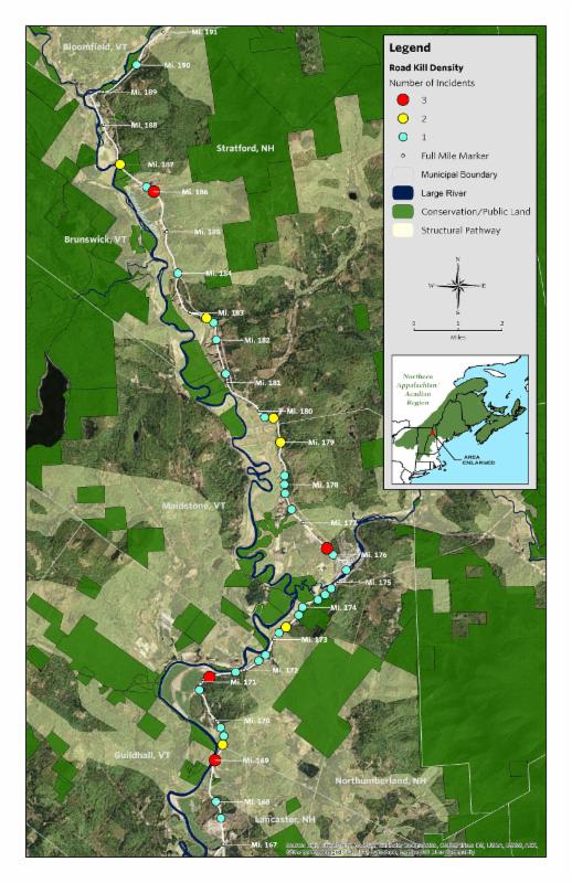
The New Hampshire Department of Transportation (NH DOT) recently completed a one-year pilot road kill inventory project, with The Nature Conservancy (TNC), on a portion of U.S. Route 3 in northern New Hampshire. For each road kill record collected, the date of the collection, closest mile m
arker, species, and any roadside features within 50 feet were recorded. Fifty-one road kill incidents were collected, including black bear (3), coyote (1), deer (12), fox (3), hedgehog (2), raccoon (19), skunk (10), and weasel (1). Of particular interest, based on a preliminary review of the dataset, nearly 60 percent of the records were in close proximity to residences and businesses, 11 of the records were associated with guardrails, four with adjacent forest cover, three with a farm/field, and one with a parallel running river. This draft road kill hotspot map shows locatio
ns of road kill records from the pilot study. TNC hopes to work with NH DOT to pair this data with historical road kill observations not captured by the pilot study to further understand longer term wildlife-vehicle collision hotspots. For
more information,
contact Pete Steckler
.
|
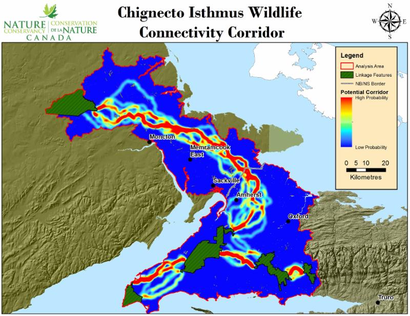
Chignecto Isthmus Connectivity Study
Nature Conservancy of Canada (NCC) has completed a connectivity analysis for the Chignecto Isthmus, an important SCI linkage area that provides the only terrestrial connection between Nova Scotia and the rest of North America. The movement of terrestrial wildlife and plants in this corridor is limited by roads, development, agriculture, and forestry. The analysis included modeling habitat suitability across the area for twelve wildlife species and identifying optimal connectivity corridors based on species' needs. Based on these results, the analysis identified and prioritized private land parcels that could be secured for conservation. The results are now being used to direct road segment surveys and camera studies on priority roads crossing the modelled corridor. To date, NCC has protected 3,386 acres (1,371 hectares) on the Chignecto Isthmus. This project was made possible by the Nova Scotia Habitat Conservation Fund and the New Brunswick Wildlife Trust Fund. Read the
2016 report covering the entire region
or the
2014 report covering New Brunswick
only.
|
Conservation Grants for Maine Appalachian Mountain Corridor
|
|
|
Photo credit: Charlie Reinertsen
|
The Maine Mountain Collaborative (MMC) recently announced the launch of the "Maine Appalachian Mountain Corridor Conservation Fund." This $100,000 fund will provide financial assistance for land conservation projects in the 5 million-acre western Maine mountain region. It supports transaction costs associated with donated conservation lands or easements and furthers MMC's mission to bring new sources of conservation funding into the region as well as innovative new land conservation strategies for areas of high ecological importance. This new fund, made possible by a grant from the Jessie B. Cox Charitable Trust Fund at the Boston Foundation, is meant to assist both small and large land trusts across the entire region.
Learn more.
|
Upcoming Events
SCI webinar about working with private landowners: September 11, 2 PM Eastern. For details, contact Jessie Levine.
SCI partners will be presenting our collaborative work at these upcoming conferences:
Are you planning an event that SCI partners may be interested in attending?
Let us know.
|
|
Questions, comments, or content for our next newsletter?

|
|
|
|
| The Staying Connected Initiative, a program of Two Countries One Forest, promotes wildlife habitat connections in an increasingly fragmented landscape. This unique cross-border public/private partnership includes over 30 collaborators, spanning five northeastern states and three Canadian provinces, working to ensure that people and wildlife thrive together. |
|
|
|