Study investigates hindcast modeling of oil slick persistence from natural seeps
Source: Remote Sensing of Environment
Article Highlights
-
- Natural oil slicks were identified by synthetic aperture radar over an active seep in the northern Gulf of Mexico.
-
- Surface oil drift model reproduced the trajectory of observed oil slicks.
-
- The average residence time of oil slicks is 6.4 h, shorter than previously thought.
-
- Wind > 7 m s− 1 is the dominant factor reducing the residence-time of surface oil.
-
- Oil slicks can persist in excess of 30 h in low wind and strong currents condition.
|
Persistence of oil floating in the ocean is an important factor for evaluating hydrocarbon fluxes from natural seeps and anthropogenic releases into the environment. An article in the latest issue of
Remote Sensing of Environment details the work of FSU researchers Samira Daneshgar ASL,
Dmitry Dukhovskoy,
Mark Bourassa, and Ian MacDonald to estimate the surface residence-time of the oil slick and to determine the importance of wind and surface currents on the trajectory and fate of the released oil. Oil slicks released from natural hydrocarbon seeps located in Green Canyon 600 lease block and its surrounding region in the Gulf of Mexico were analyzed in this study and a Texture Classifying Neural Network Algorithm was used to delineate georectified polygons for oil slicks from 41 synthetic aperture radar images. Results indicated that the surface currents are, indeed, responsible for stretching oil slicks and that surface winds are largely responsible for the disappearance of the oil slicks from the sea surface. Under conditions of low wind and strong current, natural seeps can produce oil slicks that are longer than 20 km and persist for up to 48 hours.
|
The Florida Climate Center has released the 2016 Annual Climate Summary for the state of Florida. Some highlights from the summary, which is available on the Center's website, include:
- 2016 was the second-warmest year in the instrumental record statewide after 2015; six of the 12 months ranked in their respective top-ten warmest.
- The state-averaged rainfall total for the year ranked near the median value in the instrumental value. Particularly in areas that received less rainfall from Hurricanes Hermine and Matthew, the second half of the year was drier than the first half and included a record-dry November.
On 2 September, Hurricane Hermine was the first hurricane to make landfall on the state in nearly 11 years since Hurricane Wilma in 2005, a record-long period of time. And although it did not make landfall on Florida, the center of Hurricane Matthew, a major hurricane, passed within 30 miles of the central and northern eastern coast, producing major impacts for the northeastern quarter of the peninsula.
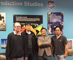
COAPS hosts colleagues from
the Korea Polar Research Institute
Last year, COAPS researchers
Steven Cocke and
Dong-Wook (DW) Shin began collaborating with the
Korea Polar Research Institute (KOPRI) to develop a prototype of a quasi-real-time weather/ climate prediction system for data collection, model initialization, forecast, evaluation, and visualization in a web environment. The project team gathered at COAPS in November to work face-to-face on development of a system that is expected to be of great value to the weather/climate prediction society and lead to improved forecasts.
|
|
|
Pictured above: Steven Cocke, Baekmin Kim, Sang-Yoon Jun, and Dong-Wook (DW) Shin
|
Paper looks at some counter-intuitive Indian summer monsoon seasons
Usually when the onset of the summer monsoon season occurs early we expect a longer season and therefore a wetter season as a whole. However, there are a significant minority of years when that early onset of the season ends up being drier than a normal wet season. A recent
article published in the Journal of Climate details an analysis of such seasons to understand their cause. Authors
Vasu Misra,
Akhilesh Mishra, and Ryne Noske found that in such early onset years, there is significant cooling of the Bay of Bengal as a result of wind forcing that subsequently leads to weakening of the rains. In the usual anomalous years, the monsoon rains are sustained after an early onset by ENSO (La Ni
ña) forcing despite the cooling of Bay of Bengal.
|
Marine Data Center staff trains research vessel marine technicians
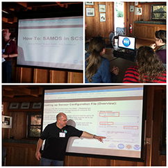
In November,
Jeremy Rolph and
Shawn Smith from the Marine Data Center (MDC) provided a short training course to a small, but enthusiastic, audience at the 2016 University-National Oceanographic Laboratory System's Research Vessel Technical Enhancement Committee (UNOLS-RVTEC) meeting in La Jolla, CA. The focus of the training, entitled
How to SAMOS in SCS, was to provide research vessel marine technicians with an overview of the steps required to submit weather and surface oceanographic observations to the Shipboard Automated Meteorological and Oceanographic System (SAMOS) initiative using NOAA's Scientific Computer System (SCS) software. SCS is the core of what is known as a data acquisition system on a research vessel. These systems record continuous observations from dozens of weather, ocean, navigation, and other automated sensors on the vessel while it is at sea. Over the years, the MDC team has become well versed in SCS and recently developed the training materials presented in La Jolla. In addition, the team used a fully portable computer and weather instrumentation system to demonstrate how to set up and run SAMOS data acquisition events on a vessel. This was the first use of this portable training system and we plan to evolve the training based on feedback from the participants in La Jolla.
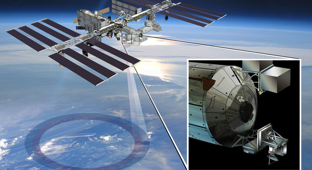
Informing the nation's space-based earth-system science programs
The Steering Committee for the National Academies of Science Earth Science and Applications from Space (ESAS) is tasked with generating recommendations for an integrated and sustainable approach to the conduct of the U.S. government's civilian space-based Earth-system science programs. As a member of the ESAS Weather and Air Quality panel, Mark Bourassa, Associate Director of COAPS, is engaged in the ongoing process of presenting information from the from the environmental monitoring and Earth science and applications communities to help inform NASA, NOAA, and the USGS earth sensing satellite missions for the next decade.
|
|
|
NASA's ISS-RapidScat satellite bounces microwaves off the ocean surface and measures the return pulses. Stronger signals mean rougher seas, caused by stronger winds. Ocean-wind data are critical for short- and long-term weather forecasts, tracking storms, analyzing climate trends and understanding the interplay of wind, ocean and sea life.
|
|
|
 Hats off to undergraduate meteorology student and research assistant Jacob Carstens. In addition to his work at COAPS producing the monthly Indian Ocean FSU wind products and conducting directed research into sea temperature sensors on research vessels and working on his senior thesis focuses on tropical cyclone integrated kenetic energy (led by Dr. V. Misra) , Carstens is also honing his skills as a broadcaster as a regular weathercaster on FSU Weather, a completely student produced weather show from Florida State University airs live at 6:00pm Eastern, Monday through Friday. Carstens also recently produced a segment highlighting COAPS that aired 28 November 2016 (see 21:30 min into video link above). Hats off to undergraduate meteorology student and research assistant Jacob Carstens. In addition to his work at COAPS producing the monthly Indian Ocean FSU wind products and conducting directed research into sea temperature sensors on research vessels and working on his senior thesis focuses on tropical cyclone integrated kenetic energy (led by Dr. V. Misra) , Carstens is also honing his skills as a broadcaster as a regular weathercaster on FSU Weather, a completely student produced weather show from Florida State University airs live at 6:00pm Eastern, Monday through Friday. Carstens also recently produced a segment highlighting COAPS that aired 28 November 2016 (see 21:30 min into video link above).
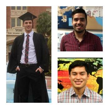 Congratulations to three Marine Data Center students -- Arturo Valery (pictured on left), Nick Contreras (top right), and Jonathan Reynes Congratulations to three Marine Data Center students -- Arturo Valery (pictured on left), Nick Contreras (top right), and Jonathan Reynes
(bottom right) -- who graduated this Fall with their bachelor's degrees in Computer Science.
Recent PhD graduate Heather Holbach is continuing her work on surface wind speed observations and extending software algorithms at the NOAA Atlantic Oceanographic and Meteorological Laboratory Hurricane Research Division in Miami, FL. Holbach's work, which is expected to take her into the skies on future NOAA hurricane reconnaissance flights, is focused on observing to a much larger portion of hurricanes than is currently possible.
|
|
Infographics series seeks to explain complex programs and concepts in easy-to-understand graphics
 While some areas of science are easy for even for non-experts to understand and appreciate, others are complex and difficult to relate in terms that a layperson can appreciate. The infographic (or information graphic) is a tool that helps people visualize complicated concepts or processes in order to improve understanding. By using graphics, we can enhance the human visual system's ability to see patterns and trends, which is particularly helpful when trying to While some areas of science are easy for even for non-experts to understand and appreciate, others are complex and difficult to relate in terms that a layperson can appreciate. The infographic (or information graphic) is a tool that helps people visualize complicated concepts or processes in order to improve understanding. By using graphics, we can enhance the human visual system's ability to see patterns and trends, which is particularly helpful when trying to
present information quickly and clearly to recipients unfamiliar.
At right is the first in a series of infographics being developed by COAPS as part of our ongoing education and outreach efforts. It tells the story of the Shipboard Automated Meteorological and Oceanographic System (SAMOS). The Marine Data Center at FSU COAPS is home to SAMOS, which captures and shares the extensive and nearly continuous meteorological data collected by research vessels. SAMOS gets the meteorological data and other measurements collected by research vessels while they are at sea. But more importantly, SAMOS makes these data available to individual researchers, organizations, and weather forecast agencies that, in turn, use them to validate weather satellite data from the National Aeronautics and Space Administration (NASA). Validated data can be used to create and improve computer models and other tools employed in weather forecasting. The SAMOS system is an important part of our nation's weather forecasting capabilities - allowing scientists to validate satellite observations with what ships at sea observe. For more detailed information about SAMOS view the SAMOS fact sheet.
|
|
Recent Publications
COAPS authors are in bold.
|
Holbach, H., and M.A. Bourassa, 2017:
Platform and Across-Swath Comparison of Vorticity Spectra From QuikSCAT, ASCAT-A, OSCAT, and ASCAT-B Scatterometers.
IEEE Journal of Selected Topics in Applied Earth Observations and Remote Sensing, PP(99):1-9.
Krishnamurti, T. N. S. Jana, R. Krishnamurti, V. Kumar, R. Deepa, F. Papa,
M. A. Bourassa, and
M.M. Ali, 2017:
Monsoonal Intraseasonal Oscillations in the Ocean Heat Content over the Surface Layers of the Bay of Bengal.
J. Marine Systems, 167, 19-32.
Misra. V., A. Bhardwaj, and R. Noske, 2016. Understanding variations of the length and the seasonal rainfall anomalies of the Indian Summer Monsoon, Journal of Climate, 29(24), Early Online Release. DOI: 10.1175/JCLI-D-16-0501.1
Shropshire, T., Y. Li, and R. He, 2016.
Storm impact on sea surface temperature and chlorophyll a in the Gulf of Mexico and Sargasso Sea based on daily cloud-free satellite data reconstructions,
Geophys. Res. Lett., 43, 12,199-12,207, doi:10.1002/2016GL071178.
Stukel, M. R., L. I. Aluwihare, K. A. Barbeau, A. M. Chekalyuk, R. Goericke,A. J. Miller, M. D., Ohman, A. Ruacho, H. Song, B. Stephens, and M. R. Landry, 2016: Mesoscale ocean fronts enhance carbon export due to gravitational sinking and subduction. Proceedings of the National Academy of Sciences. Early edition published online.
|
|