North Plains Water News

November 2024

2024 Production Reports are Available!

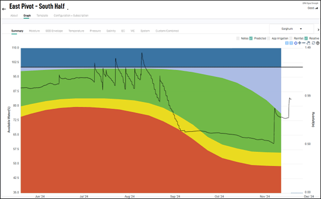
The online Production Portal is now available to production report recipients for them to access their annual reports. The new online access gives report recipients the ability to fill out their report(s) online and send it directly to the district. It also allows report recipients the option to download the blank production report(s) to pdf files, fill out and send by email or mail just as they have always done. A computer will be set up in the district office and available for any producer who needs staff assistance accessing their reports, downloading them or filling them out online.


Note: Report recipients must have an updated cell phone number and email address on file with the district before accessing reports. The email address will ensure report recipients receive status updates of the production reports after they submit them.


To access the portal, log in to the web browser on a computer or iPad here or through our website. The link is located on the front page. Once the user clicks the link they will be prompted to sign in with their phone number the district has on file. Then, a text message will be sent with an access code used to log-in. This is why having the correct cell phone number on file is so important.


A step by step instructional video is available here. If you need any assistance or have questions the video does not answer for you, do not hesitate to reach out to one of the administration staff at (806) 935-6401 or email your question(s) to productionreporting@northplainsgcd.org


For those production report recipients who choose to download a blank report to fill out and send it, email the completed report to productionreporting@northplainsgcd.org or mail it to:

North Plains Groundwater Conservation District (NPGCD)

PO Box 795

Dumas TX 79029

Change of Ownership for Groundwater Production Units (GPU) - 2024 Production Reporting


If you have bought or sold property this production year, please notify the district with the property's new ownership and production report recipient information immediately.


Any changes in GPUs (Groundwater Production Units) must be requested by filling out and sending the form linked below to the productionreporting@northplainsgcd.org.


Request to Establish a GPU Form


In order for the change to be in effect for 2024 Production, the request and the GPU document must meet all district GPU rules and be filed with the district no later than December 31, 2024. Please allow 2 weeks for District Admin Staff to review and set-up the requested GPU document.

Winter Water Levels!


The North Plains Groundwater Conservation District will be conducting winter water level measurements in all eight counties of the district. These water level measurements are used to calculate decline rates, depth to water, depletion, and saturated thickness across the district. We measure over 400 wells over the span of 3 months starting in January and wrapping up in March. The data collected over the years is used to create hydrographs. Each hydrograph creates a trend line from all the past measurements. Trendline analyses are done and combined with the depletion and decline rate calculations to create contour maps to show the differences in water levels across the district.


You can find this information in the Hydrology Report here.


Definitions:

Depth to water- the distance from the land surface to the top of the water table or aquifer.

Hydrograph- a way of displaying water level information over time.

Saturated thickness- the water contained in the aquifer between the bottom of the aquifer or redbed and the top of the water table.

Please contact Odell Ward PG, Aquifer Science Manger at oward@northplainsgcd.org or phone (806) 935-6401 ext. 210.

Registration Form

WCC Demonstration Update

By David Sloane, Ph. D


Fall Precipitation


As you would all be aware, the district has been blessed with some significant rain recently. The Water Conservation Center (WCC) has had approximately 4.5 inches of rain in the last month, and it is interesting to watch the soil wet-up after the previous crops. The east pivot had a cotton / forage sorghum split and the west pivot had a corn / forage sorghum split. The crops grown over the 2024 season left the fields with varying degrees of soil moisture and it is interesting to observe the effect of the rain in the last month. The cotton dried the soil out the most, which was not surprising given the long warm fall and the continued water use. The cotton depleted the soil by about 10” of stored soil moisture and after the recent rain, there is still over 5” needed to fill the profile. The separate layer graph (not shown) shows that the soil is still wetting up in the top 2 feet from the surface. 

Figure 1. Cotton soil moisture graph showing almost 10” of moisture depletion and still a 5.5” deficit to fill the profile.

The forage sorghum grown on the south half of the east pivot depleted the soil profile of 5” of stored soil moisture by the time it was cut for silage. The recent rains have half-filled the profile and there is still 2.5” needed before planting next spring. It is interesting to note that a 1.5” rainfall on September 19 was not evident in the graph (Figure 2). The separate layer graph (not shown) shows that the soil is wetting at the 40” layer, indicating that the rain has done a great job of wetting the top 3 feet of soil.

Figure 2. Summary water use graph of forage sorghum grown on the south half of the east pivot. The soil was depleted of approximately 5” of moisture at harvest.

The forage sorghum grown on the west pivot shows a very similar trend to the east pivot, where the crop used about 5” of stored soil moisture. The recent rains have refilled about half of the soil profile, however what is really interesting is that the 1.5” rainfall on September 19 does show up on the west pivot. Furthermore, the sorghum that was cut for silage, undergoes a substantial amount of regrowth after the rain. This can be seen as water use (or stair-stepping) on the graph. While outwardly this water usage might seem bad, the field was planted to a wheat cover crop and so any regrowth (to cover the ground) was highly desirable. Observations show that the regrowth was fairly even on both fields and so the differences in the graph are probably due to the proximity of plants growing near the probes.

Figure 3. Summary water use graph of forage sorghum grown on the west half of the west pivot. The graph shows that the soil was depleted of 5.5” of soil moisture by harvest and that the recent rains have wet the soil substantially, so that the current deficit is only about 3.5”.

The corn grown on the east half of the west pivot (Figure 4) shows that the crop depleted the soil of over 6” of stored soil moisture. This was slightly higher than was observed in previous seasons but was probably due to the long, hot finish to the season. The 1.5” rain that came after harvest did a great job of wetting up the soil profile. This was similar to the other side of the same circle, but unlike the sorghum half, there was no subsequent water use, and all of the rainfall was retained. The more recent rain has almost fully refilled the soil profile, and this field is looking good for next season.


As you can see, the different crops took different amounts of stored soil moisture, with cotton really drying out the profile this year. Even though there has been great rainfall recently (around 4.5”), the cotton field is still running a 5” deficit. While cotton doesn’t require a lot of in-season irrigation compared to other crops, care must be taken to make sure you refill the soil profile before the next crop. Soil moisture probes kept in after the season has ended are a great way of knowing where you finished the last crop and ensuring you start the next crop in a position to be successful.

Figure 4. Summary graph showing corn water use across the season and subsequent wetting of the soil due to post season rainfall.

Community Outreach

Ag Day with local 4th graders from Dumas Elementary Schools, Cactus Elementary, Dalhart Christian Academy, and Sunray Elementary. Conservation Outreach Specialist, Baylee Barnes presented students with basic information about their water and how to conserve it. As a finale students made their own edible aquifer.

Path to Plate with 8th Graders from Dumas Jr. High. Students played the district's version of Loteria, "Wateria". Student's were able to learn about their aquifer and water by playing a high stakes game, competing for bead necklaces. District staff had the help of local 4H2O Ambassadors Tara Easterling and Lucas Hill.

Important Links...


Facebook  Twitter  Instagram