Sharing information and making connections from the headwaters to the gulf.
July 6, 2022
Welcome!
This bulletin is designed as a way to share information with those interested in nutrient runoff issues and impacts. We hope you find this a valuable resource and encourage you to be a part of the exchange! You can share resources or information for inclusion in future bulletins, or join the distribution list, by sending an email to noaa.centralregion@noaa.gov.
Outlooks and Forecasts
NOAA Forecasts Summer 'Dead Zone' in the Gulf of Mexico
The National Oceanic and Atmospheric Administration (NOAA) is forecasting a summer “dead zone” in the Gulf of Mexico of approximately 5,364 square miles, making it about average for the 35-year history of the summertime dead zone measurements in the region. The forecast is lower than last year’s measured size and slightly lower than the five-year average measured size of 5,380 square miles.
The dead zone, or hypoxic area, is an area of low oxygen which can kill fish and other marine life. It occurs every summer and is primarily a result of excess nutrient pollution from human activities in cities and farm areas throughout the Mississippi River watershed. When the excess nutrients reach the Gulf, they stimulate an overgrowth of algae, which eventually die and decompose, depleting oxygen as they sink to the bottom. The resulting low oxygen levels near the bottom of the Gulf cannot support most marine life. Fish, shrimp and crabs often swim out of the area, but animals that are unable to swim or move away can be stressed or killed.
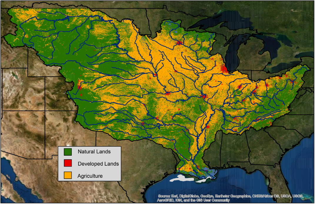
The Mississippi River watershed is made up of farms (yellow), cities (red), and natural lands (green). Nitrogen and phosphorus pollution in runoff and discharges from agricultural and urban areas are the major contributors to the annual summer hypoxic dead zone in the Gulf of Mexico (gray). (USGS)
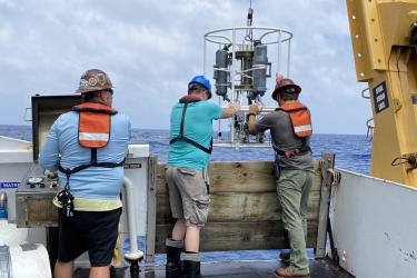
To confirm the size of the hypoxic zone and refine the forecast models, a NOAA-supported monitoring survey is conducted each summer. While the forecast assumes typical coastal weather conditions, the measured dead zone size could be disrupted by major weather events, such as hurricanes and tropical storms.
The Interagency Mississippi River and Gulf of Mexico Hypoxia Task Force has set a long-term goal of reducing the dead zone to approximately 1,900 square miles. Through the Bipartisan Infrastructure Law, the U.S. Environmental Protection Agency (EPA) is investing $60 million over the next five years to support the implementation of nutrient reduction strategies that will address the challenge of Gulf hypoxia.
Expect an Above-Normal Atlantic Hurricane Season
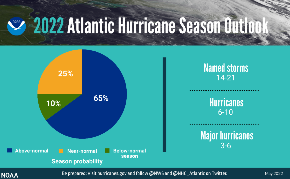
This year's hurricane season could be more active than normal, according to NOAA. The agency's outlook for the 2022 Atlantic hurricane season, which extends from June 1 to November 30, predicts a 65% chance of an above-normal season, a 25% chance of a near-normal season and a 10% chance of a below-normal season.
For the 2022 hurricane season, NOAA is forecasting a likely range of 14 to 21 named storms (winds of 39 mph or higher), of which 6 to 10 could become hurricanes (winds of 74 mph or higher), including 3 to 6 major hurricanes (category 3, 4 or 5; with winds of 111 mph or higher). NOAA provides these ranges with a 70% confidence. This would make 2022 the seventh consecutive above-average hurricane season.
The increased activity anticipated this hurricane season is attributed to several climate factors, including the ongoing La Niña that is likely to persist throughout the hurricane season, warmer-than-average sea surface temperatures in the Atlantic Ocean and Caribbean Sea, weaker tropical Atlantic trade winds and an enhanced west African monsoon. An enhanced west African monsoon supports stronger African Easterly Waves, which seed many of the strongest and longest lived hurricanes during most seasons.
A summary infographic showing hurricane season probability and numbers of named storms predicted from NOAA's 2022 Atlantic Hurricane Season Outlook. (NOAA)
Spotlight: USGS WaterWatch
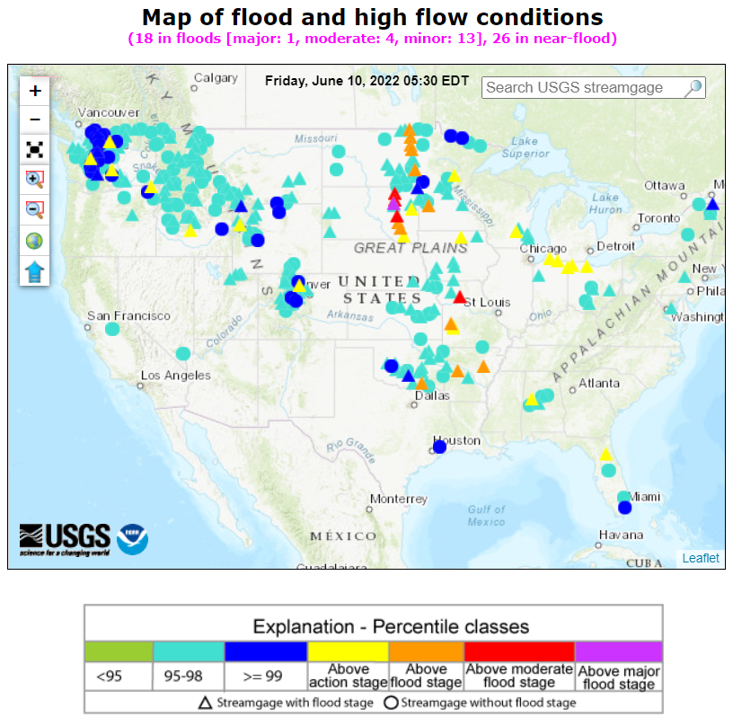
WaterWatch is a U.S. Geological Survey (USGS) website displaying maps, graphs, and tables describing real-time, recent, and past streamflow conditions for the United States. You can find streamgage-based maps that show the location of more than 3,000 long-term (30 years or more) USGS streamgages - these maps use colors to represent streamflow conditions compared to historical streamflow; feature a point-and-click interface allowing you to retrieve graphs of stream stage (water elevation) and flow; and highlight locations where extreme hydrologic events, such as floods and droughts, are occurring. The streamgage-based maps show streamflow conditions for real-time, average daily, and 7-day average streamflow. The real-time information generally is updated on an hourly basis, and real-time streamflow maps highlight flood and high flow conditions. The 7-day average streamflow maps highlight below-normal and drought conditions.
WaterWatch map showing flood and high-flow conditions for the continental U.S. on June 10, 2022. (USGS)
You can also find hydrologic unit code (HUC) maps on WaterWatch; these are derived from the streamgage-based maps and illustrate streamflow conditions in hydrologic regions. These maps show average streamflow conditions for 1-, 7-, 14-, and 28-day periods, as well as monthly average streamflow, and they can highlight regions of low flow or hydrologic drought as well as provide historical runoff and streamflow conditions going all the way back to 1901. WaterWatch can even summarize streamflow conditions in a region (state or hydrologic unit) compared to the long-term typical condition at streamgages in the region. You can also use this USGS tool to generate tables of current streamflow information and locations of flooding, as well as summary tables and time-series plots depicting variations through time.
Nutrient Runoff News
Link Confirmed Between Red Tides and Hypoxia
Researchers from NOAA and the University of Miami have found a connection between harmful algal blooms called red tides and hypoxia (low- or no-oxygen conditions) on the west coast of Florida. In a recent study published in the journal Harmful Algae, they found that when red tides began in early summer and continued into the fall, hypoxic conditions were more likely to also occur.
While red tide is a seasonal phenomenon, some years it is worse than others and sometimes hypoxia also occurs. Since oxygen is vital for marine life, these combined red tide-hypoxia events can be devastating to marine ecosystems by causing mass die offs of marine life. “What we now better understand is why some red tide events are more severe than others, particularly for fish,” said Brendan Turley, lead author and assistant scientist at the University of Miami affiliated with NOAA’s Southeast Fisheries Science Center. Scientists are also concerned that the conditions that lead to these combined events will increase with climate change projections into the future.
Mississippi River Basin Study Highlights Success in Nitrogen and Phosohorus Control
A new study by the U.S. Geological Survey and the Environmental Protection Agency compared long-term nutrient loading near the mouth of the Mississippi River with changes in nutrient balances in the Mississippi River Basin to better understand drivers of water quality trends from 1975 to 2017. Findings indicate some success in controlling nutrients at the source. Annual nutrient balances and river loads were positively correlated between 1975 and 1985. After 1985, a disconnect between both the nitrogen (N) and phosphorus (P) balances and river loads emerged, and the subsequent river load patterns were different for N versus P.The study results showed that the surplus of nutrient inputs likely led to the accumulation of legacy nutrients in the watershed, which eventually influenced long-term changes in river loads. The researchers also explored the influence of “latent” processes that could not be quantified directly due to limited data availability; these processes could potentially include changes in watershed buffering capacity, best management practices, tillage practices, tile drainage, and precipitation. In the case of N, unmeasured latent processes were just as important in explaining changes in river loads as changes in nutrient balances, and in the case of P, they were even more important. Changes in both N balances in the watershed and latent processes increased N retention in the basin and reduced river N loads over time. In contrast, changes in P balances did not lead to a steady reduction in river P loads; rather, latent processes were more influential.
This study documents positive water quality results while showing there is still room for improvement. The water quality improvements may be the result of successful implementation of long-term nutrient management efforts in the Basin. Both N and P limit the development of hypoxia in the Gulf of Mexico, but factors that influence the river loads are different; therefore, management will have to address each nutrient separately.
$60M from Infrastructure Law for Nutrient Runoff Prevention in Mississippi River Basin
The U.S. Environmental Protection Agency (EPA) announced $60 million over the next five years to fund nutrient reduction efforts through the Gulf Hypoxia Program. Hypoxia can impact ecosystems, killing fish and other wildlife, creating aquatic dead zones in severe areas. The efforts are a key component of the Bipartisan Infrastructure Law, which provides an historic investment in our nation’s waters. This funding will deepen the Agency’s collaboration with states and agricultural partners by supporting actions of the 12 member states of the Mississippi River/Gulf of Mexico Watershed Nutrient Task Force (Hypoxia Task Force) to reduce nutrient pollution, significantly expanding and enhancing capacity of the states to improve water quality in the Gulf and throughout the Mississippi/Atchafalaya River Basin.
Hypoxia Task Force Reports to Congress
The Hypoxia Task Force (HTF) recently presented a progress report to Congress and the President. This 2022 report describes progress made toward the goals of the Gulf Hypoxia Action Plan 2008 through activities directed by or coordinated with the HTF and carried out or funded by the EPA and federal and state partners. These updates include actions, newly published science, and advancements which have occurred since the 2017 Report to Congress. Tremendous strides have been made in characterizing the hypoxic zone and many of the upstream, land-based factors that contribute to its annual formation. Among these factors, the effects of climate change are expected to result in more severe and prolonged periods of hypoxia and acidification. The HTF remains committed to its 2035 goal of reducing the five-year average areal extent of the hypoxic zone in the Gulf of Mexico to less than 5,000 square kilometers by 2035, with an interim target for reducing total nitrogen and total phosphorus loads by 20% by the year 2025.
This Report to Congress is an effective tool for the HTF to describe progress toward reducing nutrient loads to the northern Gulf, summarize lessons learned in implementing nutrient reduction strategies, and explain any adjustments to its strategies for improving water quality in the Gulf.
Erosion and Nutrient Runoff? There's a Whiskey for That...
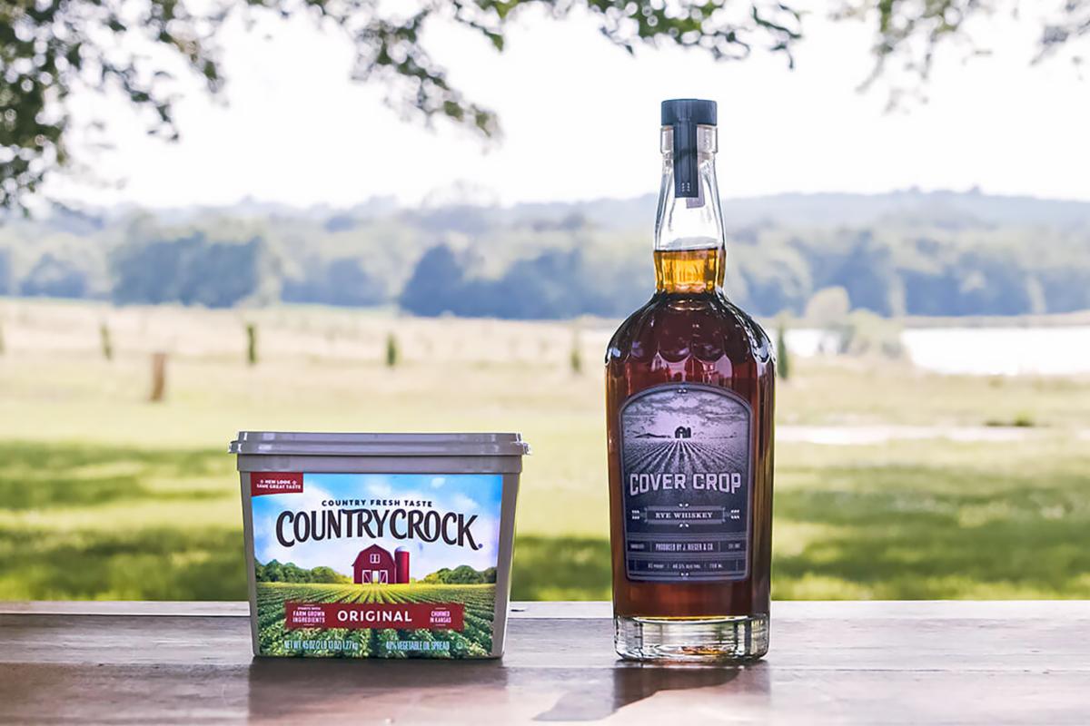
To raise awareness of sustainable farming practices, Country Crock has come out with it's own rye whiskey. Cover Crop Whiskey is the only spirit with Country Crock's official seal of approval -- named to bring awareness to the use of cover crops as a sustainable farming practice. Among the buttery spread's ingredients are soybeans sourced from farms in the brand's home state of Kansas. Country Crock states some farmers struggle with soil fatigue from repeated harvests, resulting in erosion and a lack of nutrients. "Country Crock recognized an opportunity to help educate farmers and the public on a sustainable solution: cover crops, like cereal rye, are plants grown in between harvested crops to improve soil health by returning nutrients, minimizing pests, and increasing water retention," the brand wrote in the announcement. "This has proven to be a sustainable way to keep the land healthy and reduce greenhouse gas emissions by returning carbon to the soil as a nutrient." The brand's resulting Cover Crops Project provides these local farmers with the money and training necessary to plant cover crops. And Cover Crops Whisky was developed by the ad agency Ogilvy as a way to further promote this initiative.