PaBIA's Vision: To Preserve This Unique Natural Habitat for Generations to Come
|
|
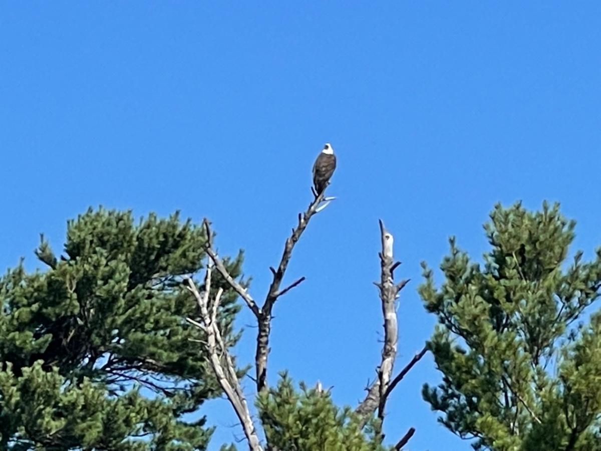
'Our' Eagle are back on Chingwauk - Thanks Trudy Irvine! |
|
What a glorious week of weather PaB has experienced! And welcome back to many Americans who have just in the past 10 days been able to return to their beloved paradise!
There are still many offerings to look forward to in these next few weeks, so be sure you are aware and have signed up wherever reservations are necessary!
|
|
In this eBlast:
IMPORTANT INFORMATION FOR ALL BOATERS
-
The S-Turn Flashing Red Light is STILL NOT Back in Service by Tom Lundy, Director of Member Safety
AUGUST
-
PaBIA/Ojibway Welcome Home Party - Everyone is Welcome - Friday, August 20
-
PaBIA Sailing August 21
-
Visit with the GBLT - August 21
-
OHPS Hosts The Talking Circle at the Ojibway - August 22 Registration is Required
-
GBB Climate Speedier Webinar August 26
OF INTEREST
-
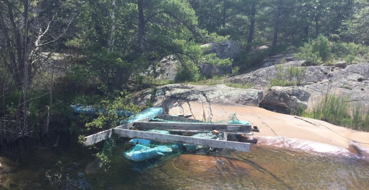
Abandoned Docks Clean Up - Need Everyone's Help - by Erica Allen
-
Last Stage for Gypsy Moth (LDD) Control by Sandy Boeckh
-
Phragmites Cutting - by Marine Patrol
- PaBIA American & International Members NOT in Canada - Special August Cottage Patrol
- PaBIA Cottage Patrol Tags for FALL, WINTER, SPRING Patrols
- ToA Asking for ID at Transfer Station
-
This Week: Water Levels: Inflow and Outflow by Helen Bryce, Education Committee
-
Lake Michigan-Huron Water Levels - August 16, 2021
-
Yearbook Update 2021 from August 12
|
|
Markers ALERT UPDATE -
The S-Turn Light REMAINS INTERMITTENTLY OUT
Submitted by Tom Lundy, Director of Member Safety
Please be advised that the S-Turn Flashing Red Light remains
OUT OF SERVICE until further notice!
We repeat, please plan any night boating accordingly.
|
|
Abandoned Dock Clean Up
PaBIA needs your help! We are hoping to engage our community to help identify and assist in the removal of unsightly and potentially very dangerous abandoned docks on our shorelines. The Township of the Archipelago has agreed to waive disposal fees and help disassemble the docks once delivered to the station.
If you know of any derelict docks please send the specific location and, if possible, a photo to Tom Lundy.
Please keep in mind some docks may belong to American cottagers who have been unable to come to their properties and we must not include these! To avoid this possibility, if you know of any derelict docks, please take a picture and send it to your American neighbours for possible identification before reporting it to Tom Lundy!
VOLUNTEERS NEEDED - Sign Up by calling Marine Patrol - (647) 545-9283
|
|
SPECIAL SUMMER COTTAGE PATROL FOR US and
INTERNATIONAL MEMBERS
Bruce Tiffin, PaBIA’s Cottage Patrolman, will provide a cottage patrol visit for PaBIA’s US and International members who are unable to be in Pointe au Baril again this year.
This special service is BY REQUEST ONLY. To have your property on the Summer Patrol, contact Nancy Rogers. Deadline for patrol requests is Friday, August 27th.
|
|
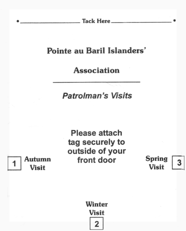
COTTAGE
PATROL TAGS
Before closing at the end of the season, please attach your patrol tags to your main cottage and any other buildings for which you’re purchased extra tags for the fall ’21, winter and spring ’22 patrols.
|
|
|
TOA Asking for Proper ID Pass at Transfer Station |
|
Please be advised that the Township has asked staff at our transfer station to request proper identification before depositing your waste. This has become a necessity as folks from outside Township of the Archipelago area, have been using our transfer station.
If you are in need of a new pass please call the township office, at (705) 746-4243. They will email you one for use on your phone. A copy of your tax assessment or Hydro bill will also suffice as identification.
Please remember these folks are only doing their job in asking you for proper identification.
Thanks…..
|
|
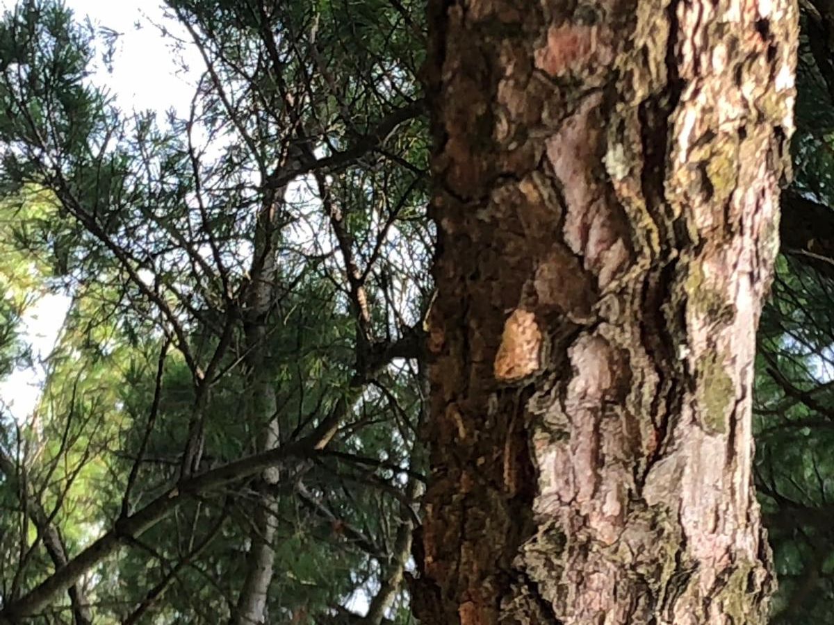
Last Stage for Gypsy Moth (LDD) Control
by Sandy Boeckh
Please note that Gypsy Moths are now being called LDD (lymantria dispar dispar) moths
While there are still some male moths being captured and killed by your LDD moth traps, it is time to move onto the final stage for control - scraping egg masses. (By all means, keep your LDD moth traps baited for as long as you observe the male moths flitting about your property!)
|
|
This final egg scraping stage lasts until next April or May when the caterpillars hatch. As you can see from the picture, egg masses are thumb size and a pine tree can hold more than a dozen masses or sacs. Each egg mass contains between 100 and 1,000 eggs...do the math, and you will see how important this stage of control is for next year’s population of LDD moths. Wearing gloves, use a plastic scraper, butter knife or spoon and scrape the masses into a small container. Then, drop all the collected masses into a bucket of soapy water and leave them for 2 days. This will ensure the eggs actually die! Only scrape the egg sacs you can easily reach. If you observe multiple masses on the underside of upper branches, you can use burlap banding next spring/early summer to trap the hatched caterpillars. Good luck!
|
|
What Impacts Our Water Levels,
What Does The Future Bring, and
What Can We Do About It?
This week: Inflow and Outflow
Previous Weeks: Precipitation & Evaporation
by Helen Bryce, Director of Education
The second most influential impacts on Georgian Bay water levels are inflows, outflows, and human-made diversions. Editor's Note: Due to the length, the article about Diversions will be next week. If you would like to read it all at once, please click here.
INFLOW, OUTFLOW, and DIVERSIONS
|
|
NATURAL INFLOW
- Water flows into the Great Lakes from thousands of streams and rivers covering a watershed area of approximately 520,587 square kilometres (201,000 square miles).
- The flow of water in the Great Lakes system moves from one lake to another eastward, ultimately flowing into the Atlantic Ocean.
- A single drop of water will take 200 years to move through this system:
- From Lake Superior, water drains into the St. Mary’s River and flows into Lake Huron
- Lake Huron and Lake Michigan are connected directly by the Straits of Mackinac
- Lake Huron waters flow into the St. Clair River, which drains into Lake St. Clair
- Lake St. Clair, in turn, drains into the Detroit River, and empties into Lake Erie
- At the end of Lake Erie, water flows into the Niagara River, dropping 52 meters (170 ft) as it flows over Niagara Falls and into Lake Ontario
- From Lake Ontario, water flows into the St. Lawrence River and ultimately runs out the Atlantic Ocean
NATURAL OUTFLOW
- But here’s a fact that may be surprising: The Great Lakes are an essentially closed system.
- Outflows from the Great Lakes are very small in comparison to their total volume: each year, less than 1% of the volume of the water in the Great Lakes flows out the St. Lawrence River.
- For Lake Michigan Huron, that 1% is equal to the top 1m of water.
- Perhaps what’s even more impressive than the flow of water through this complex interconnected system is how relatively little water actually leaves the Great Lakes Watershed each year. Great Lakes water is only replenished by 1% annually; the remaining 99% is a one-time gift from melting glaciers
ALSO NATURAL - What is the Glacial Isostatic Rebound?
- Another reason for elevated water levels is Glacial Isostatic Rebound; the rise of land masses that were depressed by the huge weight of ice sheets during the ice age.
- Around the Great Lakes, the surface is tilting southward so that land levels in the northern are rising about one foot per century while those in the south are dropping which will have an impact on shipping, recreation and shorelines.
- Also, as water levels increase, the added weight in the lake causes the lakebed to sink.
-
This is discussed further in “Rise of Great Lakes Surface Water, Sinking of the Upper Midwest of the United States, and Viscous Collapse of the Forebulge of the former Laurentide Ice Sheet” by Donald Argus.
Next week - the Diversions
|
|
POTHOLES
by Trudy Irvine, Education Committee
The complex geology of Georgian Bay is endlessly fascinating, and the scales of time and pressure involved are mind-boggling. Islands and shoals on which picnickers now warm themselves are what remains of the roots of the Grenville Mountains of two billion years ago - a range that was as high as today’s Himalayas. Laid bare by millions of years of erosion, covered for a period by sedimentary rock, and then scoured again by ice sheets in past ice ages - the flat, low topography of the resultant Shield rock is now flooded with our lovely Georgian Bay waters. All in all, the timing of our cottaging (geologically speaking) is pretty good.
One interesting geological landform common around Georgian Bay is the “pothole” - a round or cylindrical depression that can be found in all types of rock. Potholes date back to the last ice age when huge volumes of turbulent, fast-flowing waters flowed under and away from the melting ice sheet. Potholes were literally drilled into rock surfaces by boulders that were spun around in turbulent eddies. (Thank you, Nick Eyles, for your wonderful book “Georgian Bay: Discovering a Unique North American Ecosystem” where more information and photos can be found.)
Potholes several feet deep exist on multiple islands in the Pointe au Baril area. The potholes in the first photo are on the second most southerly section of the Georgian Bay Land Trust’s Lookout Island (left pic below). Do you know which one? The smaller pothole is about 2 feet wide- would you be brave enough to lower yourself in the water and find out how deep?
|
|
This pothole on the east side of Chicken Channel (pic on the right above) is well known by everyone in the immediate area. Susan Armitage remembers her son Kevin somehow bailing the water out of the hole- maybe with a bucket on a rope. (Well above the waterline on the top of a steeply sloped small island, this pothole is filled with rainwater.) The highlights Kevin remembers include a friend standing deep in the empty hole- and finding several perfectly smooth stones about 4” wide at the bottom. No doubt the stones were the remains of the boulders that carved the pothole into the bedrock themselves. There was a little too much green slime and too many frogs in the hole for Kevin’s sister Kirsten Cooke to consider the same! |
|
Part of the job for Marine Patrol is finding and handling different invasive species. One of those species is Phragmites.
How to Identify Invasive vs. Native Phragmites:
- Colour: In August, the stems of the native, non-invasive phragmites are red in colour while the invasive phragmites are more of a tan colour.
- Density: The invasive phragmites are very dense, meaning they’re many and are close together while the native phragmites are not as close together and allow for other plant and wildlife throughout.
- Flowering Time: The invasive phragmites flower in late July or early August while the native phragmites flower in early July.
If you do come across Phragmites, we recommend leaving them be and reporting the sighting to the Marine Patrol. Please do not cut or pull out the phragmites as this could spread the seed of the plant to other areas of the Bay.
If you have any questions on how to identify phragmites or safe removal of the invasive plant, feel free to contact the Marine Patrol for more information.
|
|
PaBIA Sailing Races Saturday, August 21 @ 2:00 p.m.
Check out the Sailing eBlast for all the particulars!
In order to get the complete sailing and rendezvous information, you need to receive the Sailing eBlasts. If you are not receiving these regular eBlasts, please contact Margie Wheler.
|
|
Talking Circle at the Ojibway - hosted by OHPS |
|
Visit with the Georgian Bay Land Trust |
|
On Saturday August 21st from 10 am - 2 pm, Janet Brough of the Georgian Bay Land Trust will be on the Ojibway Club dock to visit with members and talk about all things conservation. Stop by to ask your questions about the Land Trust or learn about their latest projects.
You can be a part of the GBLT's 30th anniversary celebration with new summer clothing! Choose from hoodies, hats, t-shirts and more, or cuddle up in your very own Georgian Bay blanket.
Order now for pickup on the Ojibway Club Dock August 21.
|
|
In-Person Boater Coaching
with Randy Johnson, Power Squadron Trainer
August 25 at 9:00 a.m. Ojibway Back Docks
|
|
For anyone who is interested in one to one student/coach sessions, Randy has set up two 1 hour sessions on the signup sheet found at the MP office door
- fully vaccinated and
- wishing some in-person boater coaching (how to dock that boat in the wind),
Randy will meet you at the back Ojibway docks.
Bring your own boat and learn from the Pro! Sign Ups at Marine Patrol Hut
|
|
GBB - Climate Action:
Project SPEEDIER
Thursday, August 26, 2021 10:00 AM EST
Project SPEEDIER aims to create a grid that builds towards a net-zero smart community in the Town of Parry Sound. This is a unique opportunity where a rural municipality is pledging to be net-zero in partnership with Bracebridge Generation.
|
|
Join GBF's Lunchtime Webinar on
Tackling Plastic Pollution
Georgian Bay Forever’s Tackling Plastic Pollution Webinar Series is a collection of one hour webinars aimed at raising awareness about the abundance of plastic litter entering our local and global waterways. Each webinar will end with descriptions of programs GBF has put in place to combat each issue and ways and alternatives you can implement in your life to reduce plastic waste.
|
|
The lunch-time webinar is:
Plastic Waters:
Thursday, August 26th @ 12 - 1 pm
|
|
|
Lakes Michigan/Huron Water Levels Aug 16 2021 To better read the charts, please click on the chart for the Daily or Six Month Forecast Water level chart and the corresponding websites
|
|
Yearbook Update! (as of Aug 16th)
With each eBlast, we will provide you a list of names for those members who have provided updated contact information. The details of all the changes since the 2021 yearbook came out in late April are provided in THIS printable format for you to print out and insert into your own Yearbook!
|
|
|
|
Please support
PaBIA's Yearbook's
This site's advertising feature was created to provide assistance for special local information &
events for existing Yearbook advertisers only.
|
|
Emergency
• Search and Rescue
• 800-267-7270
|
|
|
|
|
|
PaBIA Bulletin Board
For all Messages, email requests to Webmaster
|
|
|
|
Marine Patrol
(647) 545-9283
July 2- Sept 4
|
|
|
PaBIA reserves all rights regarding decisions
on communications to its members
in accordance with the
|
|
PaBIA's MIssion is to unite our island and coastal community while preserving and protecting
its unique natural environment, supporting community recreation involvement and safety. and
engaging with relevant organizations to help us achieve the vision of the Association
|
|
|
|
|
|
|