Welcome to those of you who are new members of the Colorado Geographic Alliance. COGA works with the social studies, science, environmental and technology communities to support geography in every corner of the state. Please forward this information to colleagues who might find the material of interest. The COGA Newsletter is distributed three times a year, with additional communications to selected groups as needed.
Colorado Geographic Alliance Logo
Fall 2017
In This Newsletter:
Joining NCGE?
Remember that your membership in COGA allows you to become a member of the National Council for Geographic Education at a reduced rate. Visit the NCGE website for details.

Do you teach aspiring elementary or secondary teachers? Pre-service teachers may join NCGE at no cost through the Future Geo-Leaders program.
National Geographic Alliance Network Transition
The National Geographic Society has supported education initiatives to ensure that the next generation is armed with geographic knowledge and global understanding. The Society has created a grassroots network of Geographic Alliances, established endowments to support geography education throughout the United States and focused on education professional development, state policy and the creation of resources and materials.

Recently, the National Geographic Society announced that it is re-affirming its commitment to geography education to integrate resources and assets and support educators through a highly interactive and integrated community that includes educators, explorers, storytellers, and photographers. As part of this "doubling down" on education, National Geographic is reconceptualizing the structure of the grassroots network to better leverage its expertise and technology and to make an even greater impact on students with more direct funding to educators.

National Geographic's commitment to geographic knowledge is unchanged; however, the Society is modernizing its approach and focusing its work. The National Geographic Society will have a new model with full-time National Geographic staff in each of six regions across the country. National Geographic will no longer support the  Network of Alliances for Geographic Education after October 31, 2018. The Colorado Geographic Alliance, funded as part of this program, will complete its work over the next year.

Individuals will be invited to become part of the  National Geographic Online Educator Network and participate in local projects sponsored by National Geographic. Additional conversations regarding National Geographic's work in Region 2, which includes Arizona, Colorado, Idaho, Montana, Nevada, New Mexico, North Dakota, South Dakota, Utah and Wyoming, will be hosted by National Geographic through hub meetings in each state.

Questions?  Please contact Brenda Barr, Senior Director of Educator Networks at the National Geographic Society.

Like us on Facebook

Follow us on Twitter

Check out our blog
COGA Coordinator Steve Jennings Steps Down
Thanks to Steve Jennings, Associate Professor of Geography and Environmental Studies at the University of Colorado at Colorado Springs, for his nine-year commitment to geography education as leader of the Colorado Geographic Alliance. Steve helped shepherd COGA through its strategic planning process, engaged teachers across the state in geospatial technology tools and provided a wealth of knowledge about biogeography and field experiences to the geography education community. He also served on several review panels for the Alliance Network and worked on collaborations with Arizona, Nevada, New Mexico, Oregon and Utah. Here is Steve at the recent National Conference on Geographic Education in Albuquerque, with Brenda Barr, Senior Director of Educator Networks at the National Geographic Society.
Colorado Digital Atlas
COGA Coordinator Steve Jennings is preparing a Colorado Digital Atlas that will complement the Giant Map of Colorado and create a platform for teaching about Colorado with geospatial technology. The atlas and accompanying lessons will be made available over the next several months. Keep an eye on the COGA website.
Opportunity for Pairs of Middle School Teachers to Learn about Geo-Inquiry and Power of Data 
The Colorado Geographic Alliance will be conducting a week-long Geo-Inquiry Institute in mid-June of 2018. The Geo-Inquiry process is designed to build on student questions that reflect their interest in local community issues.  Teachers (grades 6 to 8) must sign up in pairs - one teacher must be a middle school science or social studies teacher and the other must be a technology teacher or specialist.  If you are interesting in participating in this program, please submit an interest form here. For more information about the Geo-Inquiry project, visit National Geographic's website.
Professional Development Opportunities
The Colorado Geographic Alliance is partnering with the Program for Teaching East Asia at the University of Colorado, the Colorado Council for Economic Education, the DBQ Project and History Colorado to offer professional development for elementary, middle and high school teachers. Check out the workshops below to see what interests you and fits your classroom needs.
 
Integrating t he Social Studies Across Wo rld History

Enhance your skills in teaching the core concepts and tools from history, geography, economics and civics that are emphasized in Colorado's seventh grade Social Studies Standards. A subject-area expert  will help you understand how each discipline might approach the teaching of world history, using the Silk Road as a common topic. Presentations will blend content and pedagogy and you will leave with sample lessons, resources and ideas for activities including trade, primary sources, Ge oHistoGrams and a look at Silk Road communities in modern times. High school teachers of World History are also welcome! This workshop will take place on Saturday, September 9th, from 8:30 am to 4:30 pm in Denver, Colorado. For more information or to register visit the Colorado Council for Economic Education website .
 
Document Based Questions in Geography: Reading and Writing with Evidence

Join th e DBQ Project for an engaging, collaborative day. Learn ways to encourage students to ask more questions a bout geography, analyze maps, charts and text sources. Acquire skills to help students with speaking and  writing, including electronic solutions for these challenges. You will leave with a free lesson from the DBQ Project's new Mini-Qs in geography, resources from National Geographic, and information about teaching with geospatial technology. This workshop will take place on Saturday, September 30th from 9:00 am to 3:00 pm at the University of Colorado at Colorado Springs. Check out this flyer for more information and click here to register.
 
Integrating the Social Studies Across Colorado History
 
This workshop emphasizes core concepts and tools from history, geography, economics and 
civics in Colorado's fourth grade Social Studies Standards. An expert in each subject area will help you understand how each discipline views the world and, more specifically, Colorado. Presentations will blend content and pedagogy and will share resources to take back to your classroom. This workshop will take place on Saturday, October 7th from 8:30 am to 4:30 pm at the History Colorado Center in Denver. For more information or to register visit the History Colorado website .
Colorado Springs Pioneers Museum Lessons
The Colorado Geographic Alliance and the  Colorado Springs Pioneers Museum  collaborated to produce lesson plans supporting the new exhibit on the history of the Pikes Peak Region, The Story of Us, which includes a wealth of historic maps and photographs. This workshop developed lesson plans for each aspect of the exhibit; moreover, participants structured ways to guide teachers to explore the online components of the exhibit, developed mapping exercises and created annotated resource sets. You can access the lesson plans here
Giant Map Reservations for Spring 2018
The Colorado Geographic Alliance now has two Giant Maps of Colorado to share with schools across the state (that's over 1200 elementary schools, plus middle and high schools). The majority of dates for fall visits are filled, but there are still dates available in the spring of 2018.  To reserve a time for the map to visit your school, please feel out the survey . Priority for borrowing this limited resource will be given to schools that have not hosted the Giant Map in the previous twelve months. Before answering the questions on the survey, please be sure to review information about size and care, lessons and materials, user agreement and rules for the Giant Map on the Colorado Geographic Alliance website .

At this time, there is no cost to borrow the map. Each borrower will be responsible for communicating with the other borrowers and for transferring the Giant Map to the next location. COGA will endeavor to schedule map visits to avoid long distances between sites. You will receive confirmation of your date as soon as possible following your request.   The National Geographic Society continues to indicate that State Giant Traveling Maps will be available to purchase in the future. COGA will send out a special notice as soon as that information becomes available. 
Colorado Department of Education Elementary Primary Resource Sets
Educators have been busy over the summer working on new resource sets for elementary teachers. Check out topics ranging from the Ute to women and children in Colorado mining towns to the San Luis Valley.  Each set includes a Lesson Overview, Primary Source Set and Lesson Ideas, and a Resource Set. Thanks to Stephanie Hartman for organizing this project.
Geography Teacher Summer Travels
National Conference on Geography Education
by Debra Norby Colgate, Fourth Grade Teacher, Salida
 
Day 0:
Dear Diary, Ok I made it to Albuquerque with a brief stop at Meow Wolf in Santa Fe. Not really sure what I saw there, but I feel a geographer should do a study on that place, maybe even a story map, but I don't think even that would get me to an understanding of that place. It was time to scout the Old Town neighborhood for museums, breweries, happy hours and possible eating establishments...any opportunities for live music and then hit the hay and come out in the morning running. Mission accomplished.
 
At breakfast, I can smell it. There are teachers here! I have already met three teachers from Colorado and I haven't opened my mouth yet. My social anxiety has already lessened; I have met comrades from my home state! I admit, I'm feeling a little nervous at this point, they are geographers, but I do have quite a bit of experience at conferences and how to make the best choices...it's just a matter of enacting my master plan to session planning. Yes, I am a master at planning! I am feeling somewhat confident at this juncture. At the conference registration table, what do I find? Very helpful volunteers guiding me to refreshments! I am so happy there is coffee, or did I just steal coffee? I suppose I should write my master plan for the conference so I don't get side-tracked, I am a seasoned, professional, conference goer, albeit. 
    
Master Plan for Conference Planning
Day 1 - Theme Day - This year it is Native Americans and beefing up that unit for Colorado History for my students.
Day 2 - Tech Day - Yep this could be very possibly one of my "f" days-fruitful or frustrating.
Day 3 - Panic Day - Whatever-I-can-use-this-next-school-year day- I am not panicking, but I need the next big great idea for next week!

Day 1 - Theme Day
Dear Diary, Ok on to my first session. I love Primary Sources, so what could be better than Maps that are Primary Sources?? Carol Warren was a great presenter! We did engaging lessons with our session attenders, always a plus to start the day. I have so many resources to look up! Next session: "Native Americans and Indigenous People in Comic Books and Graphic Novels: How Representation Matters" (I thought the last session's title was long?) Mr. Rollins presented numerous books on the topic for different age levels. I already have an idea for my Native American storytelling unit and how to integrate with geography. Did I think of it, or did he? See I am on the collaboration geography train. So proud of myself!
Next session, whaaaaaat...there are none? I get to explore, without feeling guilty? This is the best conference EVER! 
Brooke Runnette is a very engaging speaker.  What a cool life she must have? I wonder how one person could possibly do that much. She probably has no kids? Right? There's a reception with food later? YES! Best conference ever!
 
Click here to read the full article.

Grosvenor Teacher Fellowship: A Life-Changing Expedition to the Arctic
by Jenny Bolch, Second Grade Teacher, Boulder  

Hearing the thunderous crash of a glacier calving next to you in the bright sunlight of midnight isn't something you can read about in a textbook and appreciate. Without feeling how powerful this is with the percussion and reverberating boom and nearby icebergs spinning from the impact, then why would you care about connected issues like the glaciers melting and climate change as a part of our daily reality?
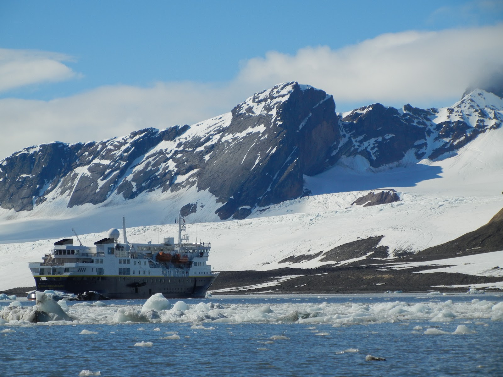
 
 Each year, National Geographic and Lindblad Expeditions select thirty teachers to go on expeditions through the Grosvenor Teacher Fellowship Program  to help solve this problem. As one of these teachers, it is my job to find ways to bring this experience back to my classroom and community.
 
As we explored Svalbard, Jan Mayen, Greenland's east coast and Iceland's west coast via the National Geographic Explorer ship, I felt like I was on board a floating school. We had experts from around the world teaching us throughout the expedition. We landed almost every day in a new and remote location (field trips!) and spent the evenings having the day's information presented to us like classes. As we hiked through the snow, experts in arctic flora pointed out the Svalbard poppy that only grows in tiny ravines where it can be protected from the harshest winds and drink the limited water that collects there. Experts in arctic fauna explained the differences between each whale that popped up next to our ship and why it wasn't a good idea to break too much ice, despite the ship's icebreaking capability, because it would cut back on the polar bear's hunting season. National Geographic photographers gave us tips on how we could get better shots to share our stories.  Geologists and polar divers passionately explained the changes that warming temperatures have on the arctic regions. Deep sea and arctic explorer Joe MacInnis spent hours inspiring me with his stories and wisdom about teamwork and leadership in high-risk environments. Here is a video interview I did with him about how children can become explorers.
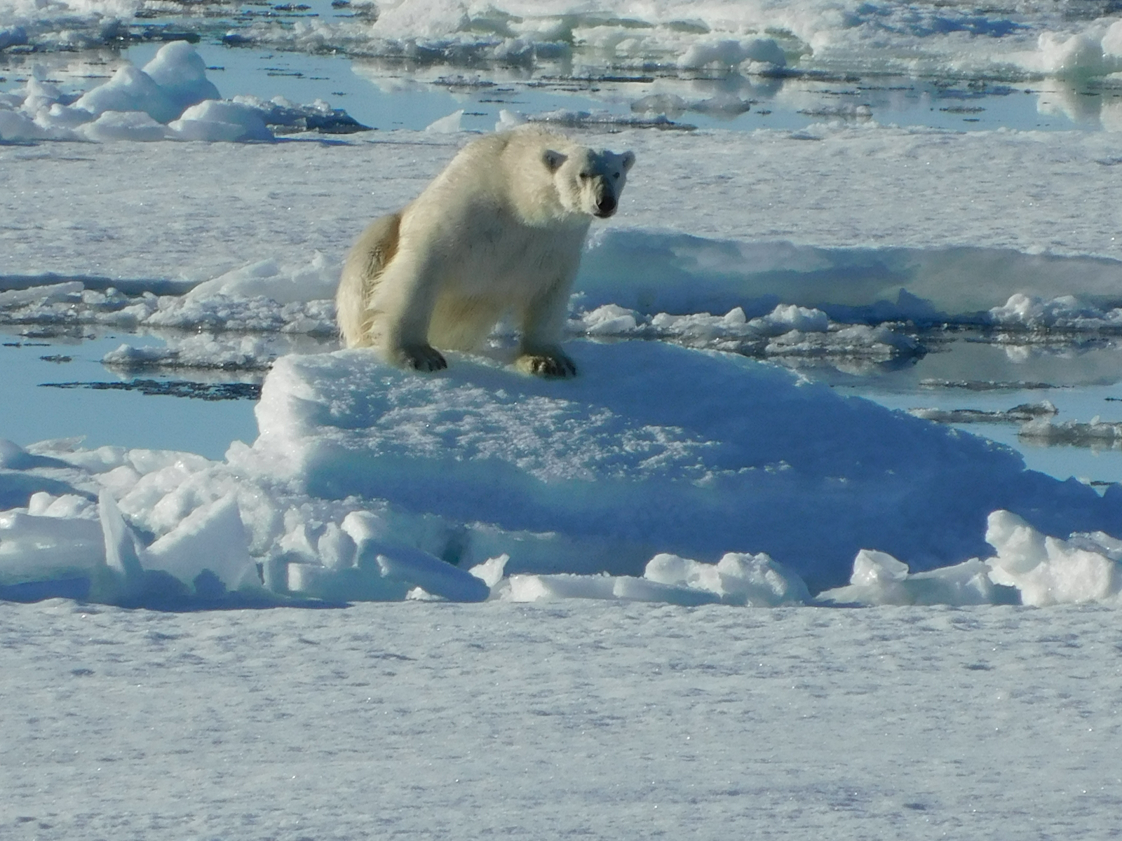
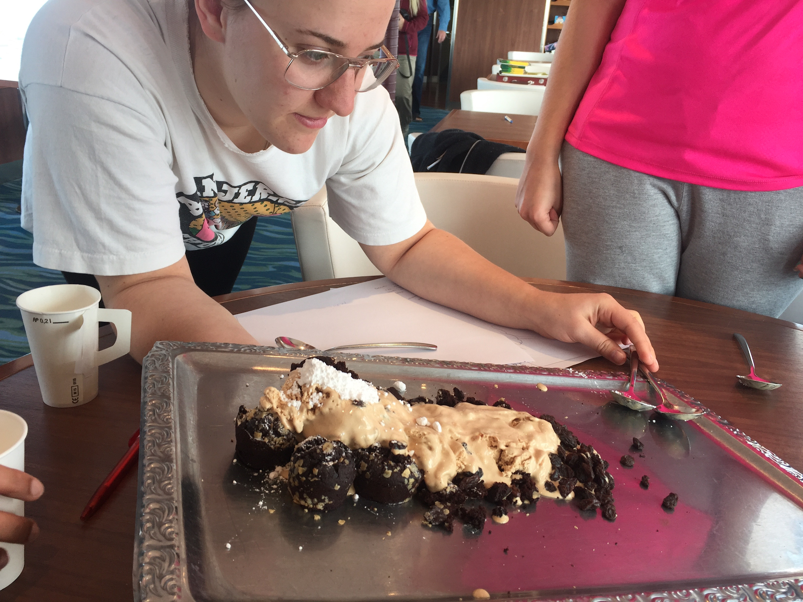
I took copious notes on everything we learned and worked with the teen group on board the ship to turn each major concept into a hands-on experiment that a second grader could learn from. Each experiment would need to be something that could be replicated by teachers that were not on board the ship, but in their own classrooms, as well as have some larger "what's the point?" connection. We constructed scientifically accurate glaciers out of ice cream and learned about why glacial rivers are silty, how climate change effects glaciers and what we can do to help. We took a presentation on thermoclines and designed an experiment with hot and cold water dyed with food coloring to show why arctic waters are more productive and how this could be affected with even a few degrees of temperature change in our oceans. 
We used melting ice cream and an apple to demonstrate the effects of permafrost and then designed a structure to keep the apple from sinking into the ice cream, explaining why houses in Svalbard and other places with permafrost can't be built directly on the ground. Over the next few months, I will be trying out these lessons and many others I have been working on with the second graders in my class. When the full curriculum is completed, teachers will be able to access it here

Another project I'm working on is writing and illustrating a series of children's books about important global issues. This expedition inspired one about climate change and how it affects animals in Polar Regions in a way that is consumable by young children. It will have a non-fiction section in the back of the book that tells ways that kids and teachers can take action to help make a difference.
 
This opportunity has been incredibly inspiring and powerful for me. It has launched me in a direction that will allow me to share what I have learned with my students and teaching community, a direction that will hopefully make a small difference in the world. 
 
Click here to view the article and see more pictures.

Geo-Inquiry Training
by Heidi Ragsdale, Eighth Grade Science Teacher, Grand Junction
 
Inquiry-based learning has always had a place within my 8th grade STEM science classroom, at West Middle School in Western Colorado, but imagine joining a full-on nationwide opportunity to help students learn to be active community problem solvers! This was my experience this summer as part of National Geographic's Geo-Inquiry professional development. 

Mike Gregorich, our school's STEM tech teacher, joined me at National Geographic's Headquarters in Washington D.C., along with 49 more states worth of eager educators, to learn the steps of the Geo-Inquiry process, which take students through 5 steps from Asking a question to Acting on a community implementation plan.  

The process is simple: Ask, Collect, Visualize, Create and Act. 

Mike and I joined teams of educators and navigated our way through the National Mall, monuments and all around our nation's capital in order to utilize the steps of the Geo-Inquiry Process, from collecting air samples, to tree specimens counts, all the way through producing a movie about a local D.C. concern. 

Some favorite moments from our training were working with the National Geographic education team, engineers and storytellers who inspired us to not only use the Geo-Inquiry Process with our students but to also help us understand how the generations of National Geographic leaders have told their own stories about our Earth.   

With its roots in both Problem Based Learning from the Buck Institute, Citizen Science and National Geographic's forces on attitudes, skills and knowledge of local regional and global impacts, this Geo-Inquiry process can help students bring direct change to our world! 
 
Following the June training, the goal of the Geo-Inquiry training is to share with teachers across the country. So look for more information coming soon from COGA and the Colorado Geo-Inquiry trainers from Grand Junction's West Middle School, Heidi Ragsdale and Mike Gregorich. Geo-Inquiry process can help students bring direct change to our world!

Cherry Creek Teacher Gets Field Experience of a Lifetime in South Korea
by David Valdez, High School Teacher, Greenwood Village
 
This past June, David Valdez, an Advanced Placement Human Geography Teacher at Cherry Creek High School, traveled with Western Michigan University professor Dr. Joseph Stoltman and 16 other AP Human Geography teachers from the United States to participate in an eight-day field study and conference in South Korea.
 
The AP Human Geography teachers participated in the Eighth Annual Geographic Naming Conference, which focused on the geopolitics of the Korean Peninsula and the territorial and geographical naming issues that have persisted since the end of World War II.
 
The naming issue is one of particular interest to the Koreans as they have worked to convince Western mapmakers to create the dual name of the Sea of Japan/East Sea on maps to honor the historical names each country uses for the body of water. Other issues included discussion about the Dokdo Islands, a pair of disputed islands located between Korea and Japan.
 
As part of the field study the group visited Panmunjom in the Demilitarized Zone between North and South Korea. The tour of the area included a visit to the Joint Security Area buildings straddling the border used for negotiations between the countries.
 
An overnight stay at the Seonusa Buddhist Temple provided insight into the teachings and practices of Korean Buddhism as well as the opportunity to participate in several temple rituals, including evening and morning chants, and a ritual of 108 prostrations.
 
Visits to historical sites, including several UNESCO Cultural Heritage sites, museums and a tour of the Hyundai Truck Assembly plant were also part of the field study; ample time was provided to explore the historic sites of Seoul.
 
The trip was organized by the Northeast Asian History Foundation, which paid for the teachers' airfare, hotel and field study and related professional activities during the visit. The NAHF sponsors this trip every year for a new group of AP Human Geography Teachers. 
 
Click here to view the article and see more pictures.
Geography Awareness Week 2017
Geography Awareness Week (GAW) will take place November 12-18. The featured theme for 2017 Awareness Week will be "The Geography of Civil Rights Movements". The American Association of Geographers ( AAG), the National Council for Geographic Education ( NCGE), the American Geographical Society ( AGS) and the Canadian Association of Geographers ( CAG) have endorsed this focus on civil rights. Click here to find out more about GAW. For resources and information regarding GAW visit COGA's website.
National Geographic Bee 2017
The Nat Geo Bee is an annual geography competition for students at the school, state, and national levels. Students in grades 4-8 compete for a chance to win up to $50,000 in college scholarships. As students study for the Bee, they learn about the world, its people, and important historical events.

Register your school today and check out the  Kahoot! quizzes to get your class excited for the challenge.  For questions about the Colorado Geographic Bee, contact Bee Coordinator Rebecca DiMaio at rardimaio@gmail.com.
Geospatial Technology
Join the GeoNet ESRI Community and explore free instructional resources for ArcGIS Online. Learn about GeoInquiries ( short, standards-based inquiry activities for teaching map-based concepts found in commonly used textbooks) and Story Maps.
 
  
Nati onal Geographic has teamed up with Google Earth. Now you can show your  students the world without leaving the classroomCheck out free  educational resources  and join Nat Geo Explorers in the field with map-based stories.
Rocky Mountain Map Society Fall Programs 
The Rocky Mountain Map Society (RMMS) meets several times a year on Tuesdays at 5:30 pm at the Denver Public Library in the Gates Room. These events are free and open to the public.
 
September 19  
Don McGuirk will present "A Survey of the Stars and Stripes on Early Maps, 1777-1795."
 
November 7
RMMS annual scholar lecture. Imre Demhardt from the Texas Map Society will present "The Rio Colorado of the West: 19 th Century exploration and cartography."
 
December 5
Richard Pegg will present "Entitled "Unique Perspectives: Japanese Maps from the 18th and 19th Centuries."
Note: This meeting will take place at the DU Library at Anderson Academic Commons (AAC), University of Denver, 2150 E. Evans Avenue.
Research Project: Analysis of the Alignment between National and State Geography Standards and Assessment 
You are invited to take part in a research project conducted by Dr. Richard G. Boehm and Joann Zadrozny of Texas State University as part of Joann's dissertation research.
 
This study is designed to analyze the level of alignment between state and national social studies/geography standards and assessments, in addition to their alignment to the curriculum taught across K-8 geography classrooms in the United States.
 
Questions are a web-based survey. All answers to the survey are anonymous. The survey should take no more than 10 minutes to complete.
 
To participate in this survey, please click here.
COGA on Facebook, Twitter, and Blog
Follow us on Facebook
Our Facebook page posts upcoming events that are open to the public. You can also find interesting links to photo galleries and articles on geography.

Follow us on Twitter
Looking for a place to upload those great photos from the visit of the Giant Map of Colorado? COGA now has a  Twitter account . Share your perspectives with #ColoradoGiantMap.

Check out our Blog
COGA's blog shares workshop opportunities and professional development sessions for educators as well as geography education resources.
Colorado Geographic Alliance
 
VISION:
Changing our understanding and
experience of the world

MISSION:
To instill and nurture spatial awareness
and geographic literacy

VALUES:
Inspiring passion for Earth and its inhabitants
Connecting people with geography
Honoring inclusivity and diversity
Exploring physical and human environments
Developing spatial perspective

Ideas for upcoming newsletters? Great topics, links, or upcoming events you'd like COGA to share with geography educators? Let us know! We're here to connect.
coga@uccs.edu

This project is funded in part by a grant from the 
National Geographic Society Education Foundation.