MARCO, MARACOOS Sign Memorandum of Understanding |
|
|
|
Maritime industries, government agencies, researchers and members of the public will have access to improved oceanographic data through a memorandum of understanding (MOU) signed between MARCO and the Mid-Atlantic Regional Association Coastal Ocean Observing System (MARACOOS). The MOU formalizes a long-standing partnership between the region’s two leading ocean data sharing, mapping, and planning organizations, and commits to the continued coordination of the Mid-Atlantic Coastal Acidification Network.
Below is a sample of the media coverage of the MOU:
|
|
Follow MARCO on . . . Instagram! |
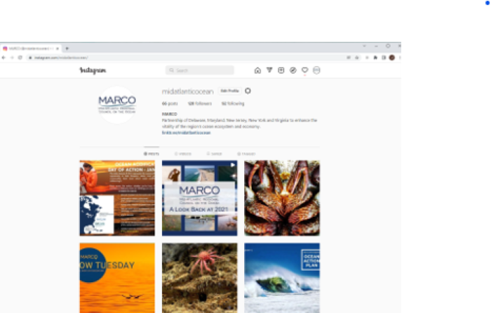
|
MARCO is excited to announce the return of our Instagram page!
You probably know by now MARCO has been using Twitter and Facebook to communicate with our stakeholders. This year, the Communications Committee will be utilizing Instagram to bring attention to the beauty of the Mid-Atlantic and MARCO's priority topics and initiatives.
You don't want to miss out on seeing some amazing photos! Check out our official relaunch post on February 2nd to honor #WorldWetlandsDay. Our first stunning picture will feature, you guessed it, our wetlands.
|
You can now follow MARCO on all 3 of our social media platforms:
FACEBOOK @midatlanticocean
TWITTER @OurOceanMARCO
INSTAGRAM @midatlanticocean
|
|
|
OA Planning Workshop Held; Next up: Webinar on OA Teacher Module |
|
|
|
The Mid-Atlantic Coastal Acidification Network (MACAN) co-hosted, “Supporting OA Action Planning and Implementation in The Mid-Atlantic” workshop in partnership with the Ocean Acidification Alliance on October 26, 2021. With the majority of the Mid-Atlantic coastal states pursuing OA Action Planning, the workshop connected over 100 researchers and state agency decision makers from across the region to support OA Action Planning.
The MACAN webinar series kicks off February 28 with "Creating a Coastal Acidification Module for Mid-Atlantic Teachers."
|
|
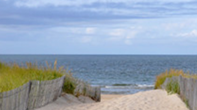
Virginia CZM Program Initiates Development of a Virginia Ocean Plan |
|
Credit: Virginia Coastal Zone Management Program |
|
In October of 2021 Virginia began a multi-year process to develop a Virginia Ocean Plan using its Section 309 Coastal Enhancement grant from NOAA. An inter-agency Virginia Ocean Policy Committee (VOPC) will guide the plan, which aims to address the identification of multiple uses and create mechanisms for baseline and ongoing monitoring. The MARCO Program Director will serve as a Regional Liaison to help inform Virginia about regional activities and data, and to connect Virginia's priorities to regional resources.
Learn more about what the plan will cover and the planning process.
|
|
Partner Spotlight: Gulf of Mexico Alliance
Governors’ Action Plan IV for Healthy and Resilient Coasts
|
|
The Gulf of Mexico Alliance recently released the Governors’ Action Plan IV for Healthy and Resilient Coasts, signed by the governors of all five Gulf states: Alabama, Florida, Louisiana, Mississippi, and Texas. This is the fourth in a series of collaborative work plans that identifies priority issues, focus areas, and actions to enhance the environmental and economic health of the Gulf of Mexico.
|
|
|
Mid-Atlantic Committee on the Ocean (MACO) Update |
|
|
|
MACO Work Groups are finalizing their 2022 work plans which will be posted on the website here. In addition you can read their 2021 progress reports.
During the January webinar for MACO stakeholders, work group leads reported on progress made and plans for 2022. Planning for the 2022 Ocean Forum will begin soon, so participants were asked which specific aspects they would like to discuss during the Forum regarding Offshore Wind, Ocean Conservation, Ocean Science, Data, and the Mid-Atlantic Portal, and DEIJ in the context of ocean planning.
Stay tuned for more information about the date and format of the 2022 Ocean Forum.
|
|
Mid-Atlantic Ocean Data Portal Winter Update |
|
MARCO has added dozens of new maps to the Portal’s themes:
- oceanography
- fishing
- renewable energy
- maritime
- marine life
Some major enhancements were made to its mapping tools at the request of users.
|
|
|
MARCO Management Board Member Spotlight – Virginia, Laura McKay |
|
|
|
As part of an effort to help MARCO stakeholders and partners get to know members of the MARCO Management Board, the quarterly newsletter has added a new feature – “Spotlight on a Management Board Member.” This month’s spotlight is on the representative from Virginia, Laura McKay, Program Manager, Virginia Coastal Zone Management Program, Virginia Department of Environmental Quality.
|
|
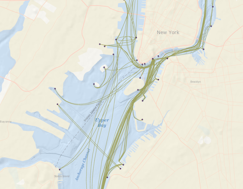
Virginia CZM Program funds Analysis of Whimbrel Migration Data |
|
Credit above ESRI
Credit below: W&M Center for Conservation Biology
|
|
Dr. Bryan Watts and his staff at the College of William and Mary’s Center for Conservation Biology have spent decades satellite tagging whimbrels that stop on Virginia’s Eastern Shore during their annual migrations.
Using existing satellite tracks of whimbrels leaving or arriving in the critical staging sites along the Delmarva Peninsula, Dr. Watts conducted a movement analysis of the tracks and estimated the overlap between the tracks and the Dominion and Kitty Hawk offshore wind leases. A considerable number (42.9%) of tracks intersected with one of the two wind leases. Data have been added to Movebank, a free online animal tracking database hosted by the Max Planck Institute for Ornithology at https://www.movebank.org.
During both fall and spring migrations whimbrels followed a southeast-northwest route. However, flight altitude is likely one of the largest factors in determining the risk of collision with turbines and data on altitude is not yet available. Research on this aspect is needed as soon as possible.
|
|
NEW YORK
NY Department of State is proud to announce Barbara Kendall, a Coastal Resource Specialist 2, recently published “Model Local Laws to Increase Resilience: A Comprehensive Resource for Municipalities along New York State’s Lakes, Rivers and Coastlines” in New York Zoning Law and Practice Report.
New York State residents, businesses, and property owners are at increased risk from the effects of climate change and extreme weather events. In addition to sea level rise and coastal flooding events, increased rain in the Northeast have threatened inland communities along New York rivers and creeks causing flash flooding and damage to infrastructure located in and/or near floodplains.
Recognizing this risk, the New York State Community Risk and Resiliency Act required that the Department of State work with the Department of Environmental Conservation and other partners to develop model local laws to help local governments increase their community's resilience.
|
|
Click to view the entire newsletter in PDF. |
|
Photo Credits: Header (L-R): Coral, NOAA-OER/BOEM; Wind turbines, Ralf Hettler; Kayaks, Raul Rosa; Shipping container, Dan Barnes; Schooling fish, Jet Chen Tan; U.S. Naval ships, Gina Addison. Body. Footer (L-R) Fishing boat, William Sherman; Diver, Michael Eversmier; Beach scene, Christie Mazzeo-Pfoertner |
|
ABOUT MARCO
Established in 2009 by the Governors of New York, New Jersey, Delaware, Maryland and Virginia, MARCO provides a forum for our coastal Mid-Atlantic states to collaborate on shared regional priorities related to marine habitats, renewable offshore energy, climate change adaptation, and ocean water quality. MARCO initiated and oversees the Mid-Atlantic Ocean Data Portal to assist the region with ocean planning efforts. For more information about MARCO, visit our website, MidAtlanticOcean.org.
CONNECT WITH US!
Thank you for your continued interest in MARCO. We welcome questions and feedback you may have, including content for upcoming issues of MARCO News. To provide comments or suggestions, or to join our email distribution list, please click "Join Our Mailing List" below, or contact us at: [email protected].
|
|
|
|
|
|
|