|
|
|

Quarterly
Newsletter
November 2020
|
SRPEDD Staff
Presents at the
2020 Moving
Together Conference
As with other recent conferences during the pandemic, MassDOT's annual Moving Together Conference was held online. Spread out over a three-day period, November 17-19, 2020, the conference continued its focus on pedestrian, bicycle, and public transportation topics. A new twist this year were program tracks, which organized the sessions into four categories - Safety, Equity Measures, Mobility in a New Normal, and Project Development and Implementation. An overarching theme of the conference was inclusion and social justice.
SRPEDD's Principal Transportation Planner Jackie Jones was on the panel for Session 5D: Southeastern MA Regional Connectivity, along with Pamela Haznar, PE, from MassDOT District 5, and Jen Carloni from the city of New Bedford. The panel focused on the growing transportation network in the South Coast region and featured SRPEDD's Closing the Gap Feasibility Study for the South Coast Bikeway and the Blue Lane in New Bedford. It was rounded out by an overview of planned and recently completed MassDOT-led projects. MassDOT and the UMass Transportation Center (UTMC) will be making these Moving Together presentations publicly available in the near future.
|
U.S. EDA-Funded Decas School Redevelopment Study Envisions a Future in R&D for Wareham
 |
| | A slide from SRPEDD's presentation to the WRA showing the study's preferred alternative. |
The Wareham Redevelopment Authority (WRA) will soon complete its year-long study of the John Decas School, slated to be decommissioned in 2021. The site presents exciting redevelopment and growth potential thanks to its strategic location and numerous local and regional assets. The United States Economic Development Administration (U.S. EDA), Massachusetts State Legislature (through District Local Technical Assistance, DLTA), and SRPEDD (through its Municipal Assistance program), provided funding for this work.
Based on a close reading of the town's 2019 Economic Development Strategy (EDS) and an analysis of current market information, SRPEDD and the WRA explored several development scenarios for the Decas School site. These scenarios drew from various EDS take-aways and built on aspects of Wareham's existing planning, all while keeping broader economic and community development goals in mind. Exploring each scenario's different facility demands, site designs, and benefits/costs enabled the team to identify a preferred alternative featuring a Research and Development (R&D) facility. Several factors, including market information, similar nearby firms, and anecdotal evidence helped support this particular opportunity. The site presents clear potential, regardless of the exact form that the eventual redevelopment takes.
The final study, expected late this year, will help the WRA to market the site and to chart a course for work with U.S. EDA, the Commonwealth, and private sector partners to determine the exact public infrastructure investments and policy initiatives that the town should pursue to achieve its desired outcomes. For more information, please visit the project web page, view a video of the recent SRPEDD presentation to the WRA, or contact SRPEDD's project lead, Grant King, at [email protected], or Economic Development Director, Don Sullivan, at [email protected].
|
SRPEDD's Regional Trails Mapping Project
The 27 communities that comprise the SRPEDD region offer many miles of public trails that provide access to nature, open space, opportunities for healthy recreation, and the potential to attract tourists. While most of these trails are well known and easily located, a number are less known and harder to find.
In the Winter & Spring of 2020, in conjunction with a statewide effort, SRPEDD began to locate and collect data on these trails to provide a unified resource for the public and our communities. We first identified trails by collecting GIS files and consolidating them into a database using mapping software. Our initial efforts yielded 414 miles of identified trails, and since then, the total number has grown to 633 miles of identified trails in the region.
Once trails have been identified and mapped, we then go out and hike those trails to validate the information on them and to gather more data. Thus far, the team has collectively hiked 128 miles of identified trails and collected such data as the condition of each trail, level of difficulty, ADA accessibility, permitted uses, and many other attributes of these important regional assets. These data points will help residents and visitors to the region explore our trails with ease and confidence while also providing valuable information to the communities and agencies responsible for the trails' stewardship.
This winter the team will be cleaning, sorting through, and soliciting feedback on the data already collected while also seeking additional information on any trails we have yet to identify. If you are interested in connecting with our team about this project please email Jackie Jones at [email protected].
|
Marion Housing Production
Plan Update
SRPEDD and the Marion Affordable Housing Trust recently met to begin the process of updating Marion's 2015 Housing Production Plan (HPP) with the intent of continuing local efforts to promote the creation and preservation of affordable housing.
Over the next several months, SRPEDD will work with the Trust to update the HPP by first revising the Plan's demographic, socioeconomic, and housing market data and evaluating the housing needs of the town's residents. Next, SRPEDD and the Trust will review the town's progress toward developing affordable housing since the completion of the last Plan. The final step of the project will be to create updated, progressive goals and implementation strategies that address new realities on the ground, and most importantly, seek to meet the evolving housing needs of Marion residents.
The next meeting with the Trust will take place in January and will consist of reviewing updated demographic and housing data. The plan is expected to be completed by September 2021 and presented to both the Planning Board and Board of Selectmen for approval. Upon approval, the Plan will then be sent to the Department of Housing and Community Development (DHCD) for state approval. Upon approval from DHCD, the Plan will be valid for a period of five years.
By taking a proactive approach to producing affordable housing via a Housing Production Plan, a community is much more likely to achieve both its housing and community planning goals. If you would like information on how SRPEDD can assist your community in developing or updating a Housing Production Plan, please contact Eric Arbeene at [email protected]
|
Assisting with Next Steps for the Assawompset Ponds Complex
 The Southeastern Regional Planning and Economic Development District (SRPEDD) was awarded technical assistance through the SNEP Network's call for participants for a climate resiliency project located within the Assawompset Ponds Complex. Located in the Massachusetts towns of Freetown, Lakeville, Middleborough, and Rochester, the Assawompset Ponds Complex is an important natural resource providing public drinking water to the region, wildlife habitat and recreation. The Southeastern Regional Planning and Economic Development District (SRPEDD) was awarded technical assistance through the SNEP Network's call for participants for a climate resiliency project located within the Assawompset Ponds Complex. Located in the Massachusetts towns of Freetown, Lakeville, Middleborough, and Rochester, the Assawompset Ponds Complex is an important natural resource providing public drinking water to the region, wildlife habitat and recreation.
The SNEP Network is supporting ongoing efforts to address flooding issues and improve climate resilience across the watershed by funding a hydraulic and hydrologic (H&H) study of the upper Nemasket River, into which the ponds flow. The H&H study will assist local decision-makers to evaluate potential restoration projects, create conceptual designs to best meet environmental needs, and utilize available funding for resource protection, restoration, and adaptation. SNEP partners of Mass Audubon, The Nature Conservancy of MA, and Kimberly Groff Consulting, along with consultants from the Horsley Witten Group, will provide technical assistance to SRPEDD and the Assawompset Ponds communities.
SNEP Network Partner, Mass Audubon, recently published a blog that details the collaborative planning efforts with regional partners in Southeastern Massachusetts that have built the foundation for the current project. Read Mass Audubon's Blog HERE.
|
|
|
|
| | |
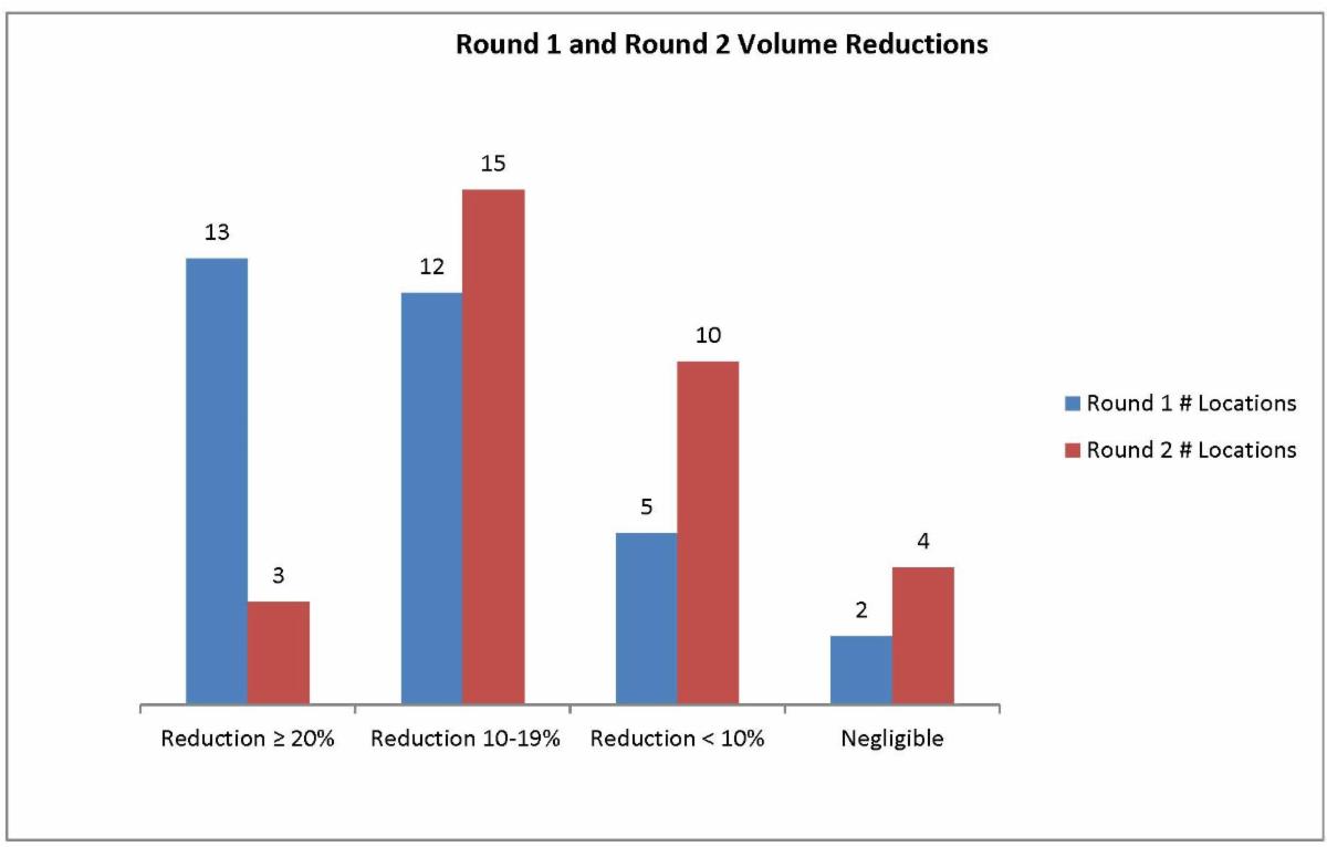
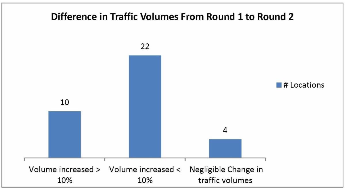
Due to the COVID-19 pandemic, traffic patterns have changed, causing MassDOT to suspend the statewide traffic counting program until the month of August. With the impact to the region and the state preparing to open in phases, SRPEDD conducted a monitoring count program, with approval from MassDOT, specific to locations within our region as people returned to work, shopping, etc. The schedule included a minimum of one location per town, and additional locations within the 4 cities in the region, totaling 36 locations. Each location was counted a minimum of three times. The first round of counting began on June 2, 2020 and the third round commenced on November 17, 2020.
In order to analyze each location, SRPEDD first researched historical data (available for 32 of the 36 locations) which was conducted by SRPEDD or MassDOT within the last 10 years. To compare counts accurately, volumes were adjusted to 2019 levels, with the latest growth factor available, using guidance provided by MassDOT. In addition, seasonal factors were applied to the counts that were collected by staff during the 3 rounds in order to get an Average Annual Daily Traffic (AADT) to compare to the historical data.
The first-round counts revealed that at 13 out of the 32 locations with historical data, traffic volumes dropped more than 20%. At twelve of the locations, traffic volumes dropped between 10% and 19%. The second-round counts revealed that at 3 out of the 32 locations with historical data, traffic volumes were still 20% lower than normal, while at 15 locations volumes were between 10% and 19% lower than normal. Although there was a variation in the percent of volume decrease at twelve locations, 28 of the 32 are still displaying a decrease in traffic volumes, which is significant. The third round of counts is currently underway and data is still being analyzed. Future updates, including the analyzed data from Round 3, will be available over the next few months. For more information about these and other area traffic counts, please contact Luis de Oliveira at [email protected].
|
|
| |
Rapid deployment search and recovery dive training
|
Southeastern Regional Homeland Security Advisory Council (SRAC) Update
Cybersecurity Trainings now online: Working closely with the other regional Homeland Security councils, the Southeastern Regional Homeland Security Council completed build-out of a six-part cybersecurity training. Based on the Department of Homeland Security's Cyber and Infrastructure Security Agency (DHS/CISA) Cyber Essentials Toolkit, these trainings launched in October 2020 for Cybersecurity awareness month.
There are six online modules developed to lead municipal officials through a holistic approach to create a cyber-secure environment. Each module focuses on a specific area, Yourself, Your Staff, Your Systems, Your Surroundings, Your Data, and Your Actions Under Stress, which together help you to build a culture of cyber readiness. The modules are self-paced and are each approximately 10 minutes in length and are available to access anytime. If you want to take the online trainings, you can do so at our website, here.
Rapid Deployment Search and Recovery Dive Training in Barnstable County: Members from the regional public safety dive teams completed a 34-hour training and certification program held in Barnstable County last month. Involving both classroom and land and water-based exercises, roughly 30 team members were certified in diving and shore tending operations.
The ability to rapidly respond to an emergency, whether it's along our long regional coastline, or one of the many rivers, lakes, ponds, and reservoirs, is key. This training ensures that area teams continue to remain certified and competent in the water-related skills needed to save lives or recover evidence.
| |
|
|
|
|
|