Safety Sidekick Newsletter
|
|
|
|
|
|
|
 |
As we enter spring there are many exciting resources and projects that the Safety Center is working on! One that we are particularly proud of is the recent release of the updated
Rural Intelligent Transportation Systems Toolkit, which you can read about in this newsletter! The Safety Center and NACE are also currently hard at work on the plans for the
2nd National Summit on Rural Road Safety and hope to provide an announcement on the date in the next few weeks.
Lastly, I want to bring your attention to new information released by FHWA on the Rectangular Rapid Flashing Beacon (RRFB) which can be found
below.
Sincerely,
National Center for Rural Road Safety
[email protected] |
|
|
|
Stakeholder Spotlight: Chris Strong
The Safety Center would like to introduce Stakeholder Team Member Chris Strong, who is the Transportation Division Manager for the city of Gresham, Oregon. Chris is a civil engineer with bachelor's and master's degrees from Rensselaer Polytechnic Institute and the University of Texas at Austin, respectively. He has been in the transportation field for over 20 years spanning planning, engineering, research, and management. His previous positions include working for a metropolitan planning organization, a consulting firm, the Western Transportation Institute (WTI), and another municipal government. He is a registered professional engineer in both Oregon and Wisconsin.
To continue reading, click
here.
|
Stakeholder Organization Spotlight: The Center for Health and Safety Culture (CHSC)
Increasing seat belt use in rural Utah counties, growing traffic safety culture to reduce impaired driving in a small community in Minnesota, and exploring the attitudes and beliefs of law enforcement officers about traffic safety enforcement are just three exciting projects at the Center for Health and Safety Culture.
 |
|
|
Social Environment |
The Center for Health and Safety Culture (CHSC) is an interdisciplinary center within the Western Transportation Institute of Montana State University serving communities and organizations through research, training, and support services to cultivate healthy and safe cultures. The Center is dedicated to applying research to develop sustainable solutions to complex social problems.
At the Center, our research focuses on understanding how culture impacts behavior, particularly behavior associated with health and safety. A cultural approach involves cultivating health and safety across all layers of the social environment (see Figure 1) that impact the behaviors of interest. By focusing on the multiple layers of the social environment involved in a behavior, change is more likely to be sustained over time.
To learn more about the Center for Health and Safety Culture, click
here.
|
Safety Center Announces Rural Intelligent Transportation Systems Toolkit
Is your agency looking for innovative solutions to your most common transportation safety challenges? Are you interested in using technology, but not sure which one best fits the needs of your rural area? Or maybe you've considered Intelligent Transportation Systems (ITS) before, but are afraid they are too expensive or only applicable in an urban setting?
The National Center for Rural Road Safety's (Safety Center) newly released Rural Intelligent Transportation System (ITS) Toolkit can answer these questions and more! Updated and expanded from its 1997 version, the new toolkit contains 42 fact sheets focused on the most common critical needs in rural areas today including: Crash Countermeasures; Traffic Management; Operations & Maintenance; Emergency Services; Surface Transportation & Weather; Rural Transit & Mobility; and Tourism & Travel Information.
Each fact sheet provides detailed information including:
- A description of the solution,
- It's applicability in a rural area,
- Key components of the system,
- Useful tips,
- Examples of implementation,
- Considerations before implementing,
- Cost information, and
- Additional resources.
Explore the new Rural Intelligent Transportation System (ITS) Toolkit on the Safety Center's
website
.
|
Safety Guide for Winter Travel
During the winter months, maintenance teams work hard to make sure roadways are prepared to handle hazardous weather conditions. Through the use of de-icing/anti-icing agents, salt spreaders, and snowplows, road crews work are at work to ensure your safety. However, the traveling public should also use every resource available to improve their own safety. During winter weather conditions, make sure that you:
- Remove snow and ice from your vehicle before you drive
- Ensure headlights and taillights are functioning properly - limited visibility during snow storms makes this paramount
- Accelerate slowly and approach bridges, shaded spots, and turns slowly
Check out the Safety Center
January Blog to learn more about how to safely travel on winter roads including a TXDOT guide to winterizing your vehicle.
|
Proven Safety Countermeasures... List Updated by FHWA
 The Federal Highway Administration began promoting tried and true infrastructure-oriented safety treatments and strategies in 2008 as their list of Proven Safety Countermeasures. That list was updated in 2012 and more recently, in 2017. Have you looked it over lately?
The current list now includes 20 potential solutions to address roadway departure, intersection, and pedestrian and bicycle crashes. Learn more about these countermeasures in the Safety Center
February Blog.
|
Not One More Life Lost on Our Roadways is the 2050 Goal: Join Us on the Road to Zero
 Have you joined yet? Road to Zero is a collaboration focused on ending traffic fatalities - a leading cause of unintentional death on our roadways within 30 years. The goal is safe mobility for all people, and members will work to develop priorities; take action individually and collaboratively; and encourage partners and stakeholders to take action to meet the goal of eliminating traffic fatalities by 2050. There is no financial obligation involved in joining the Coalition. Have you joined yet? Road to Zero is a collaboration focused on ending traffic fatalities - a leading cause of unintentional death on our roadways within 30 years. The goal is safe mobility for all people, and members will work to develop priorities; take action individually and collaboratively; and encourage partners and stakeholders to take action to meet the goal of eliminating traffic fatalities by 2050. There is no financial obligation involved in joining the Coalition.
Learn more about Vision Zero and how to join the Coalition in the Safety Center March Blog.
|
April is Distracted Driving Awareness Month
 April has been designated as Distracted Driving Awareness Month. While distracted driving is something to be tackled every day, this April we can put some extra focus on ending distracted driving. Traffic fatalities are on the increase! Check out the March Safety Center Blog to view resources and marketing materials to share the message with your colleagues. April has been designated as Distracted Driving Awareness Month. While distracted driving is something to be tackled every day, this April we can put some extra focus on ending distracted driving. Traffic fatalities are on the increase! Check out the March Safety Center Blog to view resources and marketing materials to share the message with your colleagues.
|
FHWA Update on the Rectangular Rapid Flashing Beacon (RRFB)

The Rectangular Rapid Flashing Beacon (RRFB) is now eligible for provisional use through Interim Approval (IA-21). This is a new Interim Approval, which has been updated to reflect more recent research and experience with the device.Agencies wishing to install new RRFBs will have to apply for the new Interim Approval, even if they had approval under IA-11 (rescinded in December 2017).
Additional information on treatments that comply with the MUTCD is still available here to help practitioners select the most appropriate treatment(s) for the site conditions.
|
Motor Vehicle Prioritizing Interventions and Cost Calculator for States (MV PICCS)
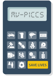 The Center for Disease Control (CDC) has a newly redesigned interactive calculator called
MV PICCS 3.0
(Motor Vehicle Prioritizing Interventions and Cost Calculator for States), pronounced MV "picks". This tool, which now includes 2015 state data and a graphical interface, can help state decision makers prioritize and select from a suite of 14 effective motor vehicle injury prevention interventions. MV PICCS 3.0 calculates the expected number and monetized value of injuries prevented, lives saved, and the costs of implementation, while taking into account available resources. The updated tool includes easy access to
intervention fact sheets
and a completely new user-friendly interface. Another new feature is the ability to save or print sharable reports with MV PICCS results. The Center for Disease Control (CDC) has a newly redesigned interactive calculator called
MV PICCS 3.0
(Motor Vehicle Prioritizing Interventions and Cost Calculator for States), pronounced MV "picks". This tool, which now includes 2015 state data and a graphical interface, can help state decision makers prioritize and select from a suite of 14 effective motor vehicle injury prevention interventions. MV PICCS 3.0 calculates the expected number and monetized value of injuries prevented, lives saved, and the costs of implementation, while taking into account available resources. The updated tool includes easy access to
intervention fact sheets
and a completely new user-friendly interface. Another new feature is the ability to save or print sharable reports with MV PICCS results.
An Example of
How MV PICCS Works is provided below using a medium-sized state. Multiple scenarios are shown to analyze the cost of implementation strategies with/without fines and fees.
Example: A medium-sized state has $1 million to implement proven interventions for motor vehicle injury prevention. The state uses CDC's MV PICCS to get state-level recommendations on which interventions would prevent the most injuries, save the most lives, and be the most cost effective. The state uses this information to help inform decision making.
Recommended Interventions:
The calculator uses any fine and fees generated by the selected interventions to supplement the state's $1 million budget.
MV PICCS recommends four interventions:
- Alcohol Ignition Interlocks
- Increased Fines for Seat Belt Use
- Universal Motorcycle Helmet Laws
- High-Visibility Enforcement for Seat Belts and Child Restraint and Booster Laws
MV PICCS Lists Potential Injuries Prevented, Lives Saved, Cost, and Revenue:
MV PICCS estimates that these four interventions would:
- Prevent 63 deaths a year
- Prevent 3,845 injuries a year
- Cost $150,000 a year
- Revenue from fines off-set the intervention costs
- $999,850,000 remains from the $1 million budget
- Have a benefit of $190,150,000 a year
- Monetary benefit of lives saved and injuries prevented
Providing Recommendations With or Without Fines:
There have been discussions in the example state around the feasibility of using fines to implement other interventions. Therefore, the state wants to provide estimates for both scenarios (with and without fines being used to supplement the available resources/budget). The state tells MV PICCS to exclude fines and fees. Without fines and fees and with a $1 million budget, MV PICCS recommends alcohol interlocks and increased seat belt fine. MV PICCS estimates that increased seat belt fine and a bicycle helmet law for children would:
- Prevent 30 deaths a year
- Prevent 2,067 injuries a year
- Cost $170,000 a year
- $999,294 remains from the $1 million budget
- Have a benefit of $95,870,000 a year
- Monetary benefit of lives saved and injuries prevented
|
Roadside Design Improvements at Curves
Roadway departure (RwD) occurs when a vehicle departs from the traveled way by crossing an edgeline or a centerline. RwD events comprise both run-off-road (ROR) and cross-median/centerline head-on collisions. Most head-on crashes are similar to ROR crashes-in both cases, the vehicle strays from its travel lane. Factors contributing to RwD collisions can be divided into two major categories: infrastructure and environmental factors and driver factors. Examples from the first include the effect of weather on pavement conditions; travel lanes that are too narrow or have substandard curves; and unforgiving roadsides. Driver factors include traveling too fast through a curve or down a grade; a driver attempting to avoid a vehicle; an object, or an animal in the travel lane; and inattentive driving due to distraction, fatigue, sleep, or drugs. Compared to other crash types, RwD is one of the most severe types of crashes. An analysis of statistics from the Fatality Analysis Reporting System (FARS) database for crash data from 2007 to 2013 reveals that an average of 59 percent of annual motor vehicle traffic fatalities in the United States occurred due to RwD. Moreover, this database indicates that 27 percent of all fatal crashes occur at curves and more than 80 percent of all fatal crashes at curves are RwD.
To combat these sober statistics, roadside design improvement at curves-
whether implemented alone or in combination with other strategies- is an essential approach, focusing on the high-risk roadside environment along the outside of the horizontal curves. It should be noted that roadside design improvements reduce the RwD fatalities through providing the errant vehicles with a better chance of recovering by providing clear zone addition, slope flattering, shoulder addition, etc. and through mitigating crash severity by installing cable barrier, guardrail, etc.
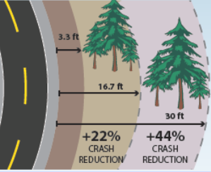
A clear zone is defined by the Federal Highway Administration
as "an unobstructed, traversable roadside area that allows a driver to stop safely, or regain control of a vehicle that has left the roadway." The clear zone area not only reduces the likelihood of a crash but also decreases crash severity. This area, which also includes a shoulder, a recoverable/non-recoverable slope, and run-out area, can be achieved by removing/relocating roadside hazard objects or reducing the steepness of the Sideslope, flattening slopes (see Figure 1).
|
|
Figure 1: Improving Clear Zone at Curves (Source: FHWA)
|
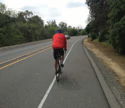
Roadway shoulders, as a safety feature, can improve road safety not only by allowing drivers to recover in a stable, clear recovery area but also by providing drivers with more space to maneuver to avoid crashes. In addition, a wider shoulder improves stopping sight distance (SSD) at horizontal curves and provides better bicycle accommodations (see Figure 2).
|
|
| Figure 2: Sample of Wider Shoulder (Source: CalTrans) |
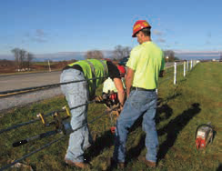
Since it is not always feasible to maintain an object-free and smooth roadside clear zone, installing roadside barriers to shield objects or embankment could be an appropriate strategy. A barrier is a device designed to stop or redirect errant vehicles to prevent a more severe crash. Although barriers cannot reduce the total number of crashes, the benefits of cable barriers are that they tend to minimize the severity of injuries by absorbing the impact of the crash and have safer consequence compared to vehicles striking the shielded obstacles. Flexible barriers, made from wire rope strung between posts, are the most forgiving type of barriers and the best option for minimizing injuries to vehicle occupants (see Figure 3).
|
|
| Figure 3: Sample of Cable Barrier (Source: MnDOT) |
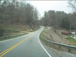
Guardrails are the most common and widely used type of barrier and can be effective in reducing: 1) reportable RwD crashes, 2) vehicles from hitting fixed objects, and 3) vehicles from going over steep embankments (see Figure 4). The most common guardrail system used in the United States is the metal beam guardrail, which consists of W-shaped metal beam rail elements fastened to wood or galvanized steel posts. Guardrails have a low life-cycle cost since they often remain functional without immediate need of repair.
|
|
| Figure 4: Sample of Guardrail (Source: NCDOT) |
|
What is Pedestrian Automatic Emergency Braking?
A pedestrian automatic emergency braking (PAEB) system is also known as frontal pedestrian impact mitigation braking. It is the technology that provides automatic braking for vehicles when pedestrians are in front of the vehicle and the driver has not acted to avoid a crash.This is an emerging technology and it is important to recognize that it may have limitations.
The system is designed to work as a crash avoidance system. When the system detects that there is a pedestrian likely to be hit by the vehicle, it either automatically applies the brakes or supplements the brakes. The pedestrian is detected by information intake of forward-looking sensors; often information is collected through cameras, but some also use a combination of cameras and radar sensors.
The PAEB system will likely come into play during four typical pedestrian crash scenarios that include when the vehicle is:
- Heading straight and a pedestrian is crossing the road;
- Turning right and a pedestrian is crossing the road;
- Turning left and a pedestrian is crossing the road; and
- Heading straight and a pedestrian is walking along or against traffic.
|
Did you know? Some Fast Facts on Rural America
 The following fast facts describe the current rural landscape in the United States in the Rural Transportation Topic Guide Series Introduction published by the National Aging and Disability Transportation Center: The following fast facts describe the current rural landscape in the United States in the Rural Transportation Topic Guide Series Introduction published by the National Aging and Disability Transportation Center:
- Population: Rural residents make up approximately 27 percent of the United States population
- Diversity: 36 million people with disabilities in the U.S. are living in non-institutionalized environments. 11 million people with disabilities live in rural areas.
- Older adults comprise more than two-thirds of rural area residents.
- Geography: Geographic factors that affect transportation availability and service in rural America include: long distances between population centers, employment opportunities, retail, and medical facilities-especially true for tribal communities and Indian reservations located in areas defined as frontier (i.e., based on travel time, distance to services, and persons per square mile); limited cellular phone reception; challenging terrain, such as steep mountains and grades; and desert weather conditions and patterns.
- Rural Transportation Fact: Approximately 38 percent of rural residents live in areas with no public transportation.
|
Great Places in America Contest
 Planning is behind the places communities value most. For more than 10 years, the American Planning Association has recognized the neighborhoods, streets, and public spaces that make communities stronger and bring people together through good planning. A "Great Place" in your community demonstrates the importance of planning, provides an opportunity for promotion and tourism, and illustrates how local policies and projects strengthen our communities. Do you have a neighborhood, street, or public space worth celebrating? To learn more and nominate a "Great Place", click here. The deadline for submissions is April 25, 2018. Planning is behind the places communities value most. For more than 10 years, the American Planning Association has recognized the neighborhoods, streets, and public spaces that make communities stronger and bring people together through good planning. A "Great Place" in your community demonstrates the importance of planning, provides an opportunity for promotion and tourism, and illustrates how local policies and projects strengthen our communities. Do you have a neighborhood, street, or public space worth celebrating? To learn more and nominate a "Great Place", click here. The deadline for submissions is April 25, 2018.
|
| Upcoming Trainings and Events |
Upcoming Safety Center Webinars
April 2018 - Sharing the Road with Slow Moving Vehicles
Date: April 26, 2018
Time: 11:00 AM to 12:30 PM Mountain/1:00 PM to 2:30 PM Eastern
In this webinar, you will be provided with an overview of slow moving vehicle related issues to include agricultural vehicles, horse and buggies, bicycles, parade/funeral vehicles, etc.
For more information or to register for this webinar, click here.
|
18th National Work Zone Awareness Week
The 2018 National Work Zone Awareness Week will be hosted by the state of Illinois, with a national kick-off event scheduled for Tuesday, April 10. Click here to learn more about this event and for resources that can help you improve work zone safety in your State.
|

2018 Lifesavers Conference
The Lifesavers Conference brings together a unique combination of public health and safety professionals, researchers, advocates, practitioners and students committed to sharing best practices, research, and policy initiatives that are proven to work.
For more information, click
here
.
|
NACE Annual Meeting/Management and Technical Conference
The conference includes a series of sessions on topics related to construction and construction management, pavement surfacing and preservation, emergency management, local road safety plans, and much more.
For more information, click
here
.
|
LTAP/TTAP Annual Conference
The National Local Technical Assistance Program Association will hold their national conference at the Hotel Monteleone in New Orleans on July 22-26, 2018. Registration information will be available here.
|

Joint ITE International and Midwestern/Great Lakes Districts Annual Meeting and Exhibit
Come out to the ITE Annual Meeting
to learn about the wide spectrum of topics that directly impact the transportation industry. You also will hear new and thoughtful viewpoints on issues which intersect, shape, and are shaped by transportation. For more information, click here.
|
National Rural ITS Conference
The National Rural ITS Conference will be held in Fort McDowell, Arizona on October 21-24, 2018.
The conference will provide participants a one-stop resource focusing on Intelligent Transportation Systems (ITS) implementation in local communities and the opportunity to hear new and thoughtful perspectives from a wide variety of ITS topics. For more information, click here.
|
| What's Hot Off the Press? |
FHWA Pedestrian Countermeasures Tech Sheets
 EDC-4 Safe Transportation for Every Pedestrian (STEP) tech sheets provide information to transportation planners, traffic safety engineers, and other decision makers about the safety benefits and design considerations for the five STEP countermeasures. Each tech sheet is a two-page, full-color summary with illustrations and safety statistics for the following countermeasures: crosswalk visibility enhancements, raised cross-walks, pedestrian refuge islands, pedestrian hybrid beacons, and road diets. The fact sheets may be printed from the following link. EDC-4 Safe Transportation for Every Pedestrian (STEP) tech sheets provide information to transportation planners, traffic safety engineers, and other decision makers about the safety benefits and design considerations for the five STEP countermeasures. Each tech sheet is a two-page, full-color summary with illustrations and safety statistics for the following countermeasures: crosswalk visibility enhancements, raised cross-walks, pedestrian refuge islands, pedestrian hybrid beacons, and road diets. The fact sheets may be printed from the following link.
|

OSHA Video Library Online
The US Department of Labor- Occupational Safety and Health Administration has taken all of the videos from their lending library and posted them online for download. The complete library may be accessed here.
|
 Getting to Zero Alcohol-Impaired Driving Fatalities: A Comprehensive Approach to a Persistent Problem Getting to Zero Alcohol-Impaired Driving Fatalities: A Comprehensive Approach to a Persistent Problem
The National Academies of Science, Engineering, and Medicine has recently released the Getting to Zero Alcohol-Impaired Driving Fatalities: A Comprehensive Approach to a Persistent Problem Report. The report is available to download through the following link.
|
Janet Leli,
Rutgers' Center for Advanced Infrastructure and Transportation
Omid Sarmid, Rutgers' Center for Advanced Infrastructure and Transportation
Jaime Sullivan, Western Transportation Institute
Karalyn Clouser, Western Transportation Institute
|
|
|
|
|