Safety Sidekick Newsletter
|
|
|
|
|
|
|
 |
In this volume of the Safety Sidekick, you will find the largest assortment of new safety resources yet! Many organizations have been busy this summer releasing new resources and we wanted to share them all with you! You can look forward to reading about a new Master's Degree in Transportation Safety, the release of the Level 2 Road Safety Professional Certification, a student video contest, a low-cost safety improvement video improvement series, the DDSA crash tree tool, a new course on automated vehicles, and many more...
On a more personal note, the Safety Center would also like to announce the retirement of our Director, Steve Albert, on June 30th. We would like to extend our sincere appreciation to Steve for his guidance over the past 4+ years, as well as, the amazing strides he has made throughout his career to ensure that rural road safety is at the forefront. To further highlight Steve's impact on rural safety, this month's stakeholder spotlight below features Steve. We hope you will join us in wishing him a happy retirement and lots of new adventures!
Sincerely,
Jaime Sullivan
Center Manager
National Center for Rural Road Safety
[email protected] |
|
|
|
Stakeholder Spotlight: Steve Albert
 This issue, we are highlighting a very special stakeholder: Steve Albert, the Safety Center's Director. Steve has served as the Director of the Safety Center since its launch in 2014, and he has led the Western Transportation Institute (WTI), which is the lead agency managing the Center, for 23 years. This summer, Steve will retire from WTI following a nearly 40-year career in transportation.
Steve started his career working on urban transportation issues in some of the most automobile-centric regions of the United States, from HOV lanes in Houston to ITS corridor deployments around Washington, DC to traffic management in Southern California. When we asked him how he got to Bozeman, Montana, where WTI is headquartered, he said, "it was love for Yellowstone National Park that romanced me to Montana and launched my transportation career on a new trajectory: rural."
To read more, click
here.
|
 Often when we discuss safe driving and dealing with elements of weather, our minds think of precipitation related threats like snow, ice, and rain. However, the summer months also have their share of unique dangers. Traffic numbers are increased due to vacationers, there are often more construction and work zones on the road, and sun glare is increased- these are just some of the exacerbated hazards during the summer months. As a result, according to the National Highway Traffic Safety Administration, the summer months are the most dangerous time of the year for drivers. Check out the Safety Center June Blog Post to learn some valuable safety tips. Often when we discuss safe driving and dealing with elements of weather, our minds think of precipitation related threats like snow, ice, and rain. However, the summer months also have their share of unique dangers. Traffic numbers are increased due to vacationers, there are often more construction and work zones on the road, and sun glare is increased- these are just some of the exacerbated hazards during the summer months. As a result, according to the National Highway Traffic Safety Administration, the summer months are the most dangerous time of the year for drivers. Check out the Safety Center June Blog Post to learn some valuable safety tips.
|
Summer...it's time to mow the lawn!
 Keeping roadsides groomed is more than cosmetic; untrimmed grass, weeds, brush, or tree limbs limit visibility and safety by obscuring signs, traffic signals, pedestrians, cyclists, and unpredictable wildlife. Roadside vegetation control seeks to improve visibility, increase safety, and promote and preserve native wildlife habitats. The crews who undertake this work are responsible for not only completing these objectives, but also for a safe vegetation control operation itself. Large vehicles are required to complete these tasks, so it is crucial for road crews to make themselves visible to people both on and off the roadways. Read the Safety Center July Blog Post to learn more about roadside vegetation management. Keeping roadsides groomed is more than cosmetic; untrimmed grass, weeds, brush, or tree limbs limit visibility and safety by obscuring signs, traffic signals, pedestrians, cyclists, and unpredictable wildlife. Roadside vegetation control seeks to improve visibility, increase safety, and promote and preserve native wildlife habitats. The crews who undertake this work are responsible for not only completing these objectives, but also for a safe vegetation control operation itself. Large vehicles are required to complete these tasks, so it is crucial for road crews to make themselves visible to people both on and off the roadways. Read the Safety Center July Blog Post to learn more about roadside vegetation management.
|
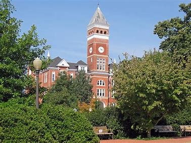
Clemson University Launches First-in-the-Nation Master of Transportation Safety Administration
Terecia Wilson, Clemson University
Clemson University is not only number one in college football but is also the first university in the nation to offer a Master of Transportation Safety Administration (MTSA) in the management and administration of highway safety programs. Developed by Clemson's Institute for Global Road Safety and Security, this new degree program addresses the need for a road safety workforce capable of deploying evidence-based strategies and best practices supported by on-going research. Students graduating from the program will be able to make a significant difference in efforts to reduce traffic fatalities and serious injuries by utilizing enhanced skills and knowledge gained through participation in the program.
What is MTSA? As an online program, MTSA is accessible to participants around the world with an interest in improving road safety and that meet admissions criteria. This unique graduate degree program is a two-year, non-thesis, 30-credit hour interdisciplinary transportation (road) safety curriculum designed to develop professionals skilled at administering and managing road safety programs involving the complex interactions of the human-vehicle-road system. The program offers fellowships to qualified applicants ranging from $2,000 to $20,000. Application fees are currently being waived as part of the program launch. Interested applicants can contact
[email protected] to obtain a waiver code to enter when applying.
The MTSA program includes four (4) three-credit hour required core courses and six (6) three-credit hour courses which are selected to form a thematic cluster. The online courses will be offered asynchronously with periodic synchronous class meetings scheduled in advancein order to facilitate access by working professionals across the globe.
Highway safety program administration and management is an interdisciplinary field, including behavioral safety programs, infrastructure safety programs (engineering), enforcement, emergency management, education, planning and design, public health, injury prevention, communications and marketing, public policy, driver and vehicle services, research, etc. The curriculum utilizes Clemson University's faculty expertise across multiple departments and colleges.
The MTSA curriculum is grounded in the belief that the future of transportation safety will require creative leadership capable of working in interdisciplinary teams and applying scientific and systems approaches to road safety management. MTSA's online courses will create a powerful learning environment for graduate students to engage in team-based learning, class lectures, case study discussions, and experiential learning for solving the real-world problems of the human-vehicle-road system. The program engages students in activities related to current national and international issues and best practices in road safety and aligns with national and international standards for core competencies that all transportation safety professionals should possess.
Applications are being accepted for the Spring 2020 semester
.
For more information about MTSA, contact MTSA Graduate Program Coordinator Dr. J. Bruce Rafert at
[email protected] or go to clemson.edu/mtsa.
To learn more about the MTSA program, click here.
|
ROADWAY SAFETY - A DISTINCT DISCIPLINE
Advancing Roadway Safety through the Road Safety Professional Certification
Priscilla A. Tobias, P.E.,
Arora and Associates, P.C.,
Illinois Operations Manager
Roadway safety is a complex issue that involves the consideration of human behavior, vehicle type, road design and operations, the interaction between different types of road users as well as with the roadway itself, and ultimately, emergency medical services. Over the past two decades significant advancements have been made in the state of practice for roadway safety due to evolving research and technology, increased implementation of evidence-based knowledge in programs to reduce traffic related fatalities and serious injuries, and initiatives such as Towards Zero Deaths (TZD) and Vision Zero.
Advancements in safety have led to increasing emphasis being placed on consideration of safety in all aspects of transportation management, making roadway safety an explicit part of a transportation professional's routine tasks. This is further demonstrated with Highway safety analysis (e.g., HSM methods, CMF applications, etc.) now being included as part of the Professional Engineer (P.E.) Exam. With this, the need to recognize roadway safety as a distinct discipline became evident. In 2016, the Transportation Professional Certification Board (TPCB) began efforts to develop a Road Safety Professional Certification (RSP). This effort has been supported by a broad cross-section of transportation and safety organizations from the United States and Canada.
The RSP Certification provides two levels of certification. RSP Level 1 is designed to demonstrate expertise in road safety's multi-disciplinary dimensions and is intended for any professional who makes decisions or takes actions that potentially impact the safety of the traveling public. RSP Level 2 is a higher-level certification with two separate distinct disciplines for certification: Infrastructure Safety and Behavior Safety and targets those individuals whose primary job functions are directed as improving road safety performance.
To learn more about RSP Certification, click
here.
|
FHWA has posted the Low-Cost Safety Improvements video series on YouTube!
These make wonderful resources to share on social media and use in presentations.
All videos may be found here.
Enhanced Delineation on Horizontal Curves -
Basic signing improvements such as advance warning signs, speed plaques, and chevrons alert drivers of upcoming curves and can reduce fatal crashes up to 44 percent. Find out how enhanced delineation at curves is saving lives in Pennsylvania.
For Unpaved Roads -
More than 80 percent of the fatal crashes on unpaved roads in 2017 were single vehicle crashes. Drivers run off the road and either rollover or strike a fixed object such as a tree or utility pole. Learn what low-cost safety strategies were used to improve unpaved roads in North and South Dakota.
Speed Management Techniques -
When speeding leads to crashes in rural towns they can be severe or fatal because it takes extra time for emergency services to arrive. Researchers at the Institute of Transportation at Iowa State University partnered with FHWA to study low-cost speed management techniques in five rural Iowa communities.
For Walking and Biking -
More than 6,000 pedestrians are killed each year along roadways. See how a small town in Oregon and a tribe in Washington are improving safety for pedestrians.
Systemic Approach for Stop-Controlled Intersections -
Alerting drivers to the presence and types of approaching intersections with signs and pavement markings can reduce the frequency and severity of crashes. Learn how South Carolina used the systemic approach to complete 80 projects for the price of one.
Longitudinal Pavement Markings -
Pavement markings are one of the least expensive countermeasures available for improving safety and can reduce crashes by 15 percent. Agencies should consider installing center lines and edge lines even where they are not required and may try adopting 6-inch edge lines rather than the standard 4-inch.
|
Have You Looked at the Rural ITS Toolkit?
The National Center for Rural Road Safety released the
Rural ITS Toolkit
late in 2018. Intelligent Transportation Systems (ITS) can help mitigate safety and mobility concerns. If you are unfamiliar with the toolkit, it is a series of 42 rural transportation critical need fact sheets. There are additional resources available, too-
 ITS Toolkit Primer - The Primer provides more information about the background of the toolkit, the intended audience, and how to use it to the fullest extent. ITS Toolkit Primer - The Primer provides more information about the background of the toolkit, the intended audience, and how to use it to the fullest extent.- ITS Toolkit Summary Table - This table provides a "snapshot" view of the tools.
- ITS Toolkit Acronym List - This resource defines all of the acronyms, that can be found throughout the fact sheets, in one easy to find location.
- Embedded Links and References Supplement - This supplemental document provides the long form of the hyperlinks used in the individual fact sheets, as well as, the references sited in the implementation and cost sections.
|
North Dakota Department of Transportation Incorporates New Technologies to Prevent Work Zone Crashes

This year, the NDDOT is incorporating the use of some new technologies in work zones to enhance safety. The NDDOT has deployed the use of Intelligent Traffic Systems technology on the I-94 project near Mandan. This technology gives real-time traffic congestion information on digital signs as motorists enter the work zone. Another technology being used for the second year in a row in North Dakota is portable rumble strips in work zones. These rumble strips are installed at various work zones to alert the driver that they are approaching a flagger in a work zone and they emphasize the need to stop or slow down.
|
Ground Penetrating Radar Helps Ensure Safe Travel on Alaska's Ice Roads
Adam Larsen, FHWA Office of Federal Lands Highway (re-published from the Spring 2019 Safety Compass newsletter with permission)
 |
|
|
Orutsararmiut Native Council Search and Rescue member Charles Guest helps monitor ice roads near Bethel.
|
On the southwest coast of Alaska, the Yukon-Kuskokwim region is home to around 25,000 people and growing. The region depends on a unique transportation network that includes very few roads. The transportation, services, supplies, and administrative hub for over 50 villages is Bethel, the eighth-largest city in Alaska. Bethel is located about 50 miles upriver from where the Kuskokwim River empties into the Bering Sea, and is accessible by river and air only.
Air travel and shipping is available in many villages, but is costly, so most residents must use alternative transportation options. In the summer, this means marine transport on the rivers and using ATV trails to haul goods. Winter travel, however, is often more perilous.
|
|
|
U.S. mail contractors travel by ice road to deliver letters and packages.
|
Each year when the rivers freeze over, crews from nine villages along the Kuskokwim and Johnson Rivers work tirelessly to keep the local ice roads clear and safe. An ice road is a winter road, or part thereof, that runs on a naturally frozen water surface such as a river or an expanse of sea ice. Ice roads provide a temporary means of transportation in isolated areas with no permanent road access. Local crews must continuously monitor ice thickness and quality and clear blown snow to ensure that those who travel over the frozen waterways via snowmobile or other vehicle type can do so safely. In addition to citizens and commercial delivery services, a wide array of government services use the ice road, including U.S. mail contractors, Alaska State Troopers, medical transports, school systems, and search and rescue emergency services (see photos at right).
Alaska's ice roads are an important means of transportation during the winter, making it possible for residents to receive deliveries of fuel, firewood, and supplies. One project taking place this past March was delivery of fuel to a village that was operating on emergency rations. Because the ice did not become thick enough during the winter to support delivery of fuel by tanker truck, the fuel delivery company arranged for a fleet of smaller fuel trucks to deliver the fuel by following a path scouted by ice road experts from the Native Village of Napaimute.
|
|
|
Ground penetrating radar sled used to monitor ice road thickness
|
Utilizing a grant from the Tribal Transportation Program Safety Fund, the ice roads crew from the Native Village of Napaimute acquired new technology that is now being used in combination with traditional knowledge to help monitor ice thickness. The device uses ground penetrating radar (GPR) and GPS technology to constantly measure and record ice thickness (see photo at right). As the device is towed on a sleigh, the measurements are wirelessly transmitted to an in-cab computer, which generates nearly instantaneous reports from the data. After about a mile of monitoring, the radar device requires calibration, which is performed by drilling a hole in the ice just large enough to measure ice thickness with a tape measure. The depth of the hole is then recorded in a computer, which adjusts the depth reported in further readings.
This past winter saw unprecedented warm weather, resulting in unusually thin, weak ice. In addition, open holes, usually smaller than 20 inches in diameter, are appearing in the ice. These holes, whose cause is unknown, are unlike anything previously seen by those with decades of experience on the ice roads. Mark Leary, Director of Development & Operations at the Native Village of Napaimute, theorized that these holes could be the results of pockets of methane gas being trapped as permafrost melts.
The use of this new GPR technology has made it possible for maintenance crews to warn travelers of the locations of thin ice, holes, or other areas where travel should be avoided. While similar devices have been used in Canada, where ice roads with limited river crossings are more common, the Kuskokwim ice road is different in that it runs over 120 miles of river rather than simply crossing water over short distances.
The GPR is especially important when heavy loads are being moved, enabling consistent monitoring of the ice road thickness over 1-mile segments. Prior to obtaining the GPR device, maintenance crews could only drill intermittently to estimate ice thickness, and thin areas could only be identified if the crew was lucky enough to drill in that spot. GPR also provides good data, helping local maintenance crews determine when it's safe to start using the ice road as well as when ice road travel should stop.
|
|
|
Demonstration of the process to calibrate the ground penetrating radar device. Adam Larsen of the FHWA Office of Tribal Transportation within the Office of Federal Lands Highway operates the drill and measures ice thickness while Mark Leary from the Native Village of Napaimute records the results.
|
Adapting to changing climate means adapting the operation of the ice roads and continuing to learn and innovate in order to ensure safe winter travel in one of the world's harshest environments. Advances in research and constantly evolving technology may be able to help increase the safety, frequency, and accuracy of the processes used to monitor ice quality and thickness.
"By combining our traditional knowledge with new technology we are able to manage safe travel despite a changing climate that produces less ice," said Leary.
Despite the many advances made in recent years, gaps in both technology and our understanding of the mechanical properties of ice roads exist, and research is needed to ensure that the use of ice roads can remain as safe as possible. For example, there is a need for methods to test the strength of ice samples and calculate the load that can be carried by ice of varying thickness. Exploring the use of drone photography, drone thermal imagery, sonar, radar, or other technology to screen ice roads for hazardous conditions such as thin ice, open water, and open water covered by snow will also help save lives by ensuring safe transportation in a difficult climate during severe winter conditions.
For more information about the Tribal Transportation Program that funded this technology, please contact Adam Larsen at [email protected].
|
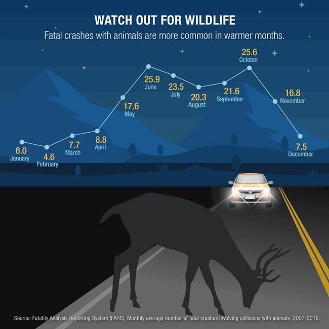
Keep Alert: Don't be like a Deer in the Headlights
Wildlife collisions occur in every state and geographical environment, but patterns can be found within crash data. According to the Insurance Institute for Highway Safety (IIHS), Texas and Wisconsin had the highest numbers of deaths from collisions with animals over the last decade. They attribute the numbers to the size of the driving population, animal population and percentage of rural roads. For additional facts and figures about collisions with animals, such as state numbers and crash severity, please visit
here
.
|
| Upcoming Trainings and Events |
Safety Center on the Move
The Safety Center will be on the move over the next month! If you will be attending one of the following conferences, please stop by the booth or our presentations!
- Governors Highway Safety Association (GHSA) 2019 Annual Meeting Aug. 24-28th in Anaheim, CA - The Safety Center will have a booth at the exhibit hall and will be presenting at the "Take Me Home (Safely), Country Roads: Challenges and Answers in Rural Road Safety" session on Aug. 27 10:30 AM to 12:00 PM PDT.
- 12th TRB International Conference on Low Volume Roads Sept. 15-18th in Kalispell, MT- The Safety Center will be presenting a workshop entitled "Low-Cost Safety Improvements for Low Volume Roads" on Sept. 15 from 1:00-4:30 PM MST and will be presenting in the "Rural Roadway Safety Plans, Technology, and Research" Session on Sept. 16 from 10:30 AM-12:00 PM.
- National Transportation in Indian County Conference (NTICC) Sept. 16-19th in Big Sky, MT - The Safety Center will be presenting a workshop entitled "Effectively Communicating Safety with Elected Officials" on Sept. 17 from 3:00-4:30 PM MDT.
|
FHWA Local Roads Safety Approach
Time: 12:00 PM to 1:30 PM Mountain/2:00 PM to 3:30 PM Eastern

Learn how local agencies benefitted from FHWA roadway safety technical assistance! This webinar will showcase roadway safety technical assistance provided to local agencies. Hear about the benefits these agencies received and how your agency can also apply for technical assistance. This webinar will feature technical assistance at one tribal and four county agencies and benefits realized.
Technical assistance came in several different formats - training, data enhancement and analysis, safety issue and countermeasure identification, and safety planning. These efforts featured collaboration between tribal and county agencies, State DOTs, FHWA, and LTAP Centers to tackle priority road safety issues. Staff from neighboring local agencies participated in the events to gain knowledge on addressing their own safety issues. Road safety benefits from this project as well as other road safety technical assistance opportunities will be highlighted during this webinar.
|
Alabama Roadway Safety Conference
The ALDOT Traffic and Safety Operations Section in the Design Bureau, along with FHWA and Auburn University are hosting the inaugural Alabama Roadway Safety Conference (previously Rural Road Safety Conference) at Grand Hotel, Point Clear Alabama, from September 24th to September 26th, 2019. The Conference will begin at 1:00 pm on the 24th and will conclude at 12 noon on the 26th. The goal of the Conference is to provide participants with knowledge of available tools, countermeasures, and processes to improve safety on all Alabama roads and highways.
|
Automated Vehicles University Course Module Series
 In the fast-paced world of automated vehicle (AV) development, university course instructors, transportation professionals, city officials, and others are struggling to not only understand the current landscape of issues that accompany this emerging technology, but also anticipate current and future planning needs to prepare for them. Understanding the basics of AVs, as well as the challenges and opportunities they present, can help those learning or working within the realm of transportation engage with the evolving effects of a driverless future, and in particular, the implications for pedestrians and bicyclists.
A new university course series from PBIC introduces these concepts, providing a foundation and orientation for students and practitioners to learn more and join the conversation about the advancement of AVs and the safety and mobility for all road users. The course series supplements existing undergraduate engineering courses and is also relevant to planning, public health, public policy, and more. The seven modules can be adapted for different lesson plans. Presentations, assignments, readings, and information for instructors are now available here.
|
ARTBA Student Video Contest Open
 The ARTBA Foundation supports an annual student video contest to promote the U.S. transportation design and construction industry. The ARTBA Foundation supports an annual student video contest to promote the U.S. transportation design and construction industry.
The Student Transportation Construction Industry Video Contest is aimed at helping students gain a better understanding of the importance of transportation infrastructure investment to the U.S. economy and quality of life, and to learn more about the industry and potential career opportunities.
ARTBA's Research & Education Division (RED) sponsors the contest and has two submission categories: general transportation impacts, trends and/or funding; and transportation safety.
The contest is divided into two age groups: elementary, middle or high school students; and post-secondary, college and graduate students. Winners are selected in each age group, for a total of four first-place videos.
Each winner receives a cash prize and winning entries may be shown during ARTBA's annual National Convention.
Entries are due October 20.
For more information, click here.
|
| What's Hot Off the Press? |
Designating Scenic Bikeways: A Framework for Rural Road Owners
The report
Designating scenic Bikeways: A Framework for Rural Road Owners develops
guidance that can be used by land management agencies - in addition to transportation agencies when considering bikeway designations to reduce liability concerns and improve safety for people biking and driving on shared roads.
|
|
The DDSA Crash Tree Tool allows users to generate crash tree diagrams based on the NHTSA Fatality Analysis Reporting System (FARS) or other crash datasets. Crash tree diagrams can be used as part of the systemic safety analysis process to help you identify and select the facility types where the focus crash types most frequently occur. The crash tree can have a number of different formats, depending on agency capabilities and data availability. The
Systemic Safety Project Selection Tool
includes additional information about the systemic safety analysis process, including examples of crash tree diagrams.
|
New Tribal Injury Prevention Resource Center Website
The Albuquerque Area Southwest Tribal Epidemiology Center (AASTEC), and Albuquerque Area Indian Health Board, Inc. (AAIHB), are pleased to announce the launch of a new website for the Tribal Injury Prevention Resource Center (TIPRC).
The interactive website is designed to provide visitors an easy way to learn about TIPRC, available services, and information on American Indian/Alaska Native motor vehicle safety. The site also contains integrated training and technical assistance request forms. Visit often for new information and updates.
|
Preparing Local Agencies for the Future of Connected and Autonomous Vehicles
 Iowa State University's Center for Transportation Research and Education has recently completed a toolbox, Preparing Local Agencies for the Future of Connected and Autonomous Vehicles, developed to provide local agencies with information about connected and autonomous vehicles. This toolbox is designed to help them prepare for the short term impacts CAV will have in their jurisdiction. Minnesota Department of Transportation was the project sponsor. To read the report, please click here. Iowa State University's Center for Transportation Research and Education has recently completed a toolbox, Preparing Local Agencies for the Future of Connected and Autonomous Vehicles, developed to provide local agencies with information about connected and autonomous vehicles. This toolbox is designed to help them prepare for the short term impacts CAV will have in their jurisdiction. Minnesota Department of Transportation was the project sponsor. To read the report, please click here.
|
Reducing fatalities on rural roads remains a major challenge in the United States. In 2016, 18,590 lives were lost on rural roads-more than half of all traffic deaths-even though only 19 percent of the U.S. population lives in rural areas. Two-thirds of these rural fatalities involved a roadway departure, where a vehicle crosses a center line, an edge line, or otherwise leaves its travel lane.
Systemic application of proven safety countermeasures on rural roads helps keep vehicles in their travel lanes and reduce the incidence and severity of roadway departure crashes.
|
New NHI Training videos available on Crash Reduction and Safety Data Analysis
The Roadway Safety Data Program (RSDP) kicked off in 2012 in response to the need among State and local agencies for support and guidance in advancing their safety data and analysis and to help fulfill the FHWA strategic goal of reducing fatalities and serious injury crashes. To support the goal of advancing agency practices, FHWA has developed several National Highway Institute (NHI) courses to address the more advanced scientific techniques and methodologies introduced in the Highway Safety Manual (HSM). These courses cover a range of areas such as network screening, diagnosis, countermeasure selection, evaluation, and predictive tool usage on two-lane rural roads, intersections, multilane highways, and freeways in an instructor-led delivery format.
For access to these resources and instructional videos, please visit the NHI Website.
|
TRIP Transportation Research Groups Issues Report on Rural Road Fatalities and Countermeasures

The report, Rural Connections: Challenges and Opportunities in America's Heartland, evaluates the safety and condition of the nation's rural roads and bridges and finds that the nation's rural transportation system is in need of immediate improvements to address deficient roads and bridges, high crash rates, and inadequate connectivity and capacity. This chart shows the states with the highest rate of rural pavements in poor condition, states with the highest share of rural bridges that are rated poor/structurally deficient, and states with the highest fatality rates on non-Interstate, rural roads.
|
South Carolina Department of Transportation Adopting Roundabouts as Safer Alternative in Rural Areas
SCDOT studies on 12 of its 22 roundabouts has shown a decrease in total crashes by 64 percent and a decrease in injury cashes by 80 percent, McCutcheon said. Roundabouts work by reducing the number of "conflict points" in a traditional four-legged intersection from 32 to eight, simplifying vehicle movements (drivers only ever need to merge to their right) and slowing intersection crossings, particularly in the more rural areas where roundabouts are commonly being installed.
|
New Noteworthy Practices Address Rail-Highway Crossing Safety and HRRR
A has been hard at work collecting noteworthy practices to help State practitioners explore effective solutions for improving rural road safety as well as safety at rail-highway at-grade crossings. This fall, four new noteworthy practices were entered into the Roadway Safety Noteworthy Practices database:
For more information on any of these practices, or to learn more about how you can improve safety on high-risk rural roads or at-grade rail-highway crossings, please visit the FHWA's High Risk Rural Roads web page.
|
Localities Embrace Vision Zero
The FHWA Office of Safety sponsored a peer exchange in Seattle, Washington to share information on approaches and practices that will help participants achieve the vision of zero traffic deaths in their localities. The participants included representatives from seven Vision Zero cities: Seattle, Washington; Anchorage, Alaska; Portland, Oregon; Minneapolis, Minnesota; Richmond, Virginia; Durham, North Carolina; and Bellevue, Washington. The purpose was to share successful practices for and approaches to improving roadway safety among the cities.
Establishing and maintaining strong stakeholder partnerships is a key component of a successful Vision Zero program. Vision Zero representatives from Durham, Richmond, and Seattle shared highlights of their approaches to training, internal and external partnerships, and strategies for outreach to communities. Check out the improvements and recommendations they made here.
|
Adam Larsen, FHWA Office of Federal Lands Highway
Priscilla A. Tobias, P.E., Arora and Associates, P.C., Illinois Operations Manager
Terecia Wilson, Clemson University
Janet Leli,
Rutgers' Center for Advanced Infrastructure and Transportation
Omid Sarmid, Rutgers' Center for Advanced Infrastructure and Transportation
Jaime Sullivan, Western Transportation Institute
Karalyn Clouser, Western Transportation Institute
|
|
|
|
|