A Newsletter from the Connecticut Department of Energy and Environmental Protection
Exploring Long Island Sound - Issues and Opportunities
| |
|
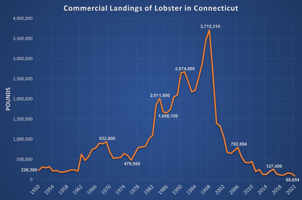
Researchers have investigated several possible causes for the crash in lobster populations including disease, changes in water quality, increases in water temperature, and other human impacts to the Sound such as pesticide use. This decline has also been confirmed by DEEP via the Long Island Sound Trawl Survey program, which surveys marine fish, squid, and lobster populations by towing nets from a research vessel. In addition, data from the surveys indicates a trend of increasing numbers of species that favor warm water and decreasing numbers of species that prefer cold water.
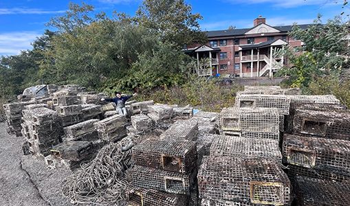
Although the lobster industry began to crash over two decades ago, the remnants of the industry continue to harm the populations of lobster and other marine life today in the form of abandoned lobster traps. It is estimated that there are about one million of these derelict traps at the bottom of Long Island Sound. These traps can disrupt habitats, interfere with navigation and commercial fishing, and leach potentially harmful chemicals into the water.
“These traps are so durable. Even after 20 years of being at the bottom of the ocean they’re still functioning and a lot of them are in working order,” said Justin Susarchick, Conservation Project Manager at the Maritime Aquarium.
These still-functional traps operate as a "ghost fishery" that continue to trap and kill marine animals who are lured in by the remains of other animals that have died in the traps, a cycle which leads to further declines in marine populations.
“Of all the traps we’ve collected, we’ve seen 90 percent of them have living or dead animals in the trap,” said Susarchick.
A similar effort to remove old lobster traps was undertaken by the Cornell Cooperative Extension of Suffolk County in New York, which has removed about 19,000 abandoned traps from New York waters since 2011. According to Scott Curatolo-Wagemann, senior educator at the agency, about 91% of those traps were still functioning, and about a third had live crabs, fish, and lobsters, including pregnant females, inside.
As of the end of 2023, the L-TRAP partners have completed 57 of 95 federally funded trips to continue removing the abandoned lobster traps from Connecticut's waters.
DEEP Commissioner Katie Dykes said, “We are thrilled that the cooperative effort to remove ghost fishing gear from Long Island Sound has achieved this notable milestone. We appreciate the effort of all the project partners in bringing to fruition the promise of the 2018 Public Act which created the ability for DEEP to authorize third parties to remove lost fishing gear from the Sound. The L-TRAP partnership is a great example of how various stakeholders can work with regulators to collaboratively deliver positive outcomes for the Long Island Sound ecosystem. We look forward to continuing to support the partnership’s important work.”
| |
|
Long Island Sound History: Lighthouses of the Connecticut Shoreline
One of the most prominent and romantic images invoked by the coastline of Long Island Sound is the turbulent waves of a storm crashing against the stone walls of a shoreline lighthouse, whose steady beacon staves off the dark clouds swirling above and guides ships to the safety of the harbor. Or, perhaps, seagulls and shorebirds resting on the rails of a lighthouse as its beacon flashes one last time, greeted by a sunrise over the calm harbor waters on a warm summer morning. Connecticut’s historic lighthouses have been a staple of our shoreline since they first began appearing in the late 18th century, and have been the subject of countless paintings, photographs, and stories. One such illustration, which regular readers are no doubt familiar with, has been featured at the top of Sound Outlook since it first debuted in 1999. In this issue, we will offer a brief history of the lighthouses that one may find along Connecticut’s land and waters.
| 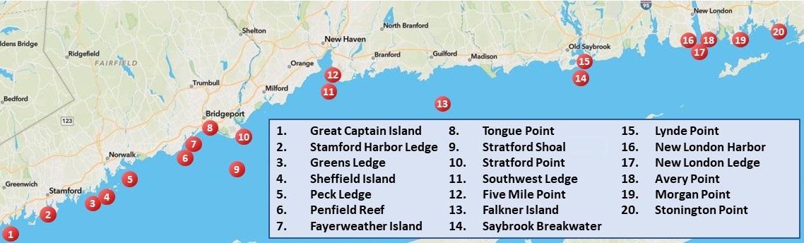 | |
Photo: Lighthouse Friends | |
|
1. Great Captain Island Light
Great Captain Island is a 17-acre island owned by the Town of Greenwich. Construction on the original lighthouse at this site was completed in 1829. However, an 1838 inspection reported that the 30-foot stone tower was poorly constructed. A new lighthouse was completed in 1868, in a similar style to lighthouses built in the same period at Sheffield Island in Connecticut and Block Island in Rhode Island, with a cast-iron tower attached to the front end of a granite keepers house. In 1890, a fog whistle was added, which was upgraded to a powerful siren in 1905.
| |
|
The sound of the new siren was so distressing to Greenwich residents that a local paper asked, "What has Greenwich done that the government inflicts such severe punishment on this community?" The siren was later modified to be somewhat more acceptable to the local population. In 1970, the light from the lighthouse was transferred to a skeletal tower. The town purchased the lighthouse from the U.S. Government in 1973. It was restored in the late 2000s, and a memorial was added commemorating residents and others with ties to Greenwich who died in the September 11, 2001 attacks, including Bennett Fisher, who championed the fundraising campaign to restore the lighthouse in the late 90s.
The island is open to the public with single entry or season park passes required from May – October. Ferry service is available in the summer months. The island is largely natural, including a pond that serves as a nesting area for migratory shorebirds such as egrets and herons.
| |
|
2. Stamford Harbor Ledge Light
Construction on Stamford Harbor Ledge Light began in 1881, and the light went into service the following year. The tower, 3600 feet from shore, is a fairly typical “sparkplug” style lighthouse of the era, a cast-iron cylindrical structure built offshore resembling a sparkplug. The interior has seven levels.
The lighthouse was deactivated by the Coast Guard as an official aid to navigation in 1953. The lighthouse has retained a weaker automatic light since its deactivation and continues to serve as a private aid to navigation.
| |
Photo: Braden Lynn/DEEP LWRD | |
In 2023, the lighthouse was sold to two men who founded the Stamford Harbor Lighthouse Project, with the goal to restore the lighthouse and preserve the environment around it. The lighthouse can be seen from around Stamford Harbor but is better seen by boat. | |
Photo: Braden Lynn/DEEP LWRD | |
|
3. Greens Ledge Light
Another “sparkplug” style light, Greens Ledge Light was completed in 1902 at Greens Ledge, near the shores of Norwalk, after the U.S. Congress appropriated $60,000 for its establishment.
Early keepers of this light faced some misfortune in their work. In 1910, Assistant Keeper Leroy Loughborough was abandoned by the principal keeper at the station, and was found half-starved and exhausted eleven days later, almost unconscious with his dog at his side. Leroy never recovered from the ordeal and died of tuberculosis within a year.
| |
|
Leroy's brother, George, later became the assistant keeper. In 1912, George went ashore to South Norwalk, and reportedly learned of an aunt’s illness and went to visit her. Keeper William T. Locke was abandoned in the lighthouse for 16 days, and was found weak, exhausted, and hungry, having reduced his rations for fear of starvation. Then, in 1917, Assistant Keeper Frank Thompson went ashore for supplies and became trapped by ice on his attempted return. He was rescued, nearly frozen, when an alert South Norwalk resident spotted his trapped boat and notified the authorities.
Over the years, and especially after the Great New England Hurricane of 1938, the lighthouse developed a tilt, and the vibrations from the station’s generators caused the furniture to move to one side of the tower. They solved the problem by only furnishing one side of the lighthouse. The lighthouse was automated in 1972.
In 2016, under the provisions of the National Historic Lighthouse Preservation Act, the lighthouse was sold at auction to a group of local residents including the Pettee family, who subsequently formed the Greens Ledge Light Preservation Society. They raised over $1.7 million for restoration, including repainting the lighthouse to bright red, consistent with early illustrations of the light. The lighthouse can be seen distantly from the shores of Norwalk and Darien and is better seen by boat.
| |
|
4. Sheffield Island Light
The first tower on 53-acre Sheffield Island in Norwalk was built in 1827 to mark dangerous ledges at the harbor entrance. The original 1826 stone keeper’s house still stands, but the site of the first tower is now underwater. The second lighthouse was built in 1868 in the same mid-Victorian style as other lighthouses of the era, including Great Captain Island and Morgan Point Lights.
When Greens Ledge Light was completed in 1902, Sheffield Island Light was deactivated. It was sold privately in 1914 and later acquired by the Norwalk Seaport Association in 1986.
| |
Photo: Connecticut Tourism Office | |
|
The lighthouse was damaged in 1993 by a tropical storm that significantly reshaped the island. It underwent restoration with the aid of the Norwalk Seaport Association and the local attention given to the preservation efforts by Norwalk Mayor Frank Esposito and several former mayors.
A solar-powered light was installed in 2011, though it is not an official aid to navigation. Sheffield Island is accessible by boat, and the Norwalk Seaport Association operates a ferry service and lighthouse tours.
| | |
|
|
5. Peck Ledge Light
As Norwalk was becoming an important commercial port, the harbor was dredged to accommodate increased ship traffic. Peck Ledge Light was proposed to mark Peck Ledge and, along with Greens Ledge Light, to replace the function of Sheffield Island Light. Peck Ledge Light was completed in 1906. The light was automated in 1933 and remains an active aid to navigation.
The lighthouse was sold to Lighthouse Preservation Group, LLC. Restoration work began on the light in 2016, including a fully renovated interior, a new dock, and replacement of the lower gallery, which had washed away during Superstorm Sandy in 2012.
| |
In partnership with the Norwalk Art Space, the lighthouse began hosting art workshops in 2023. The lighthouse can be seen distantly from the Norwalk shoreline at Calf Pasture Beach, but is best seen by boat. | |
|
6. Penfield Reef Light
After several vessels ran aground on a shoal that extends over a mile from Penfield Beach in Fairfield, Penfield Reef Light was constructed in 1874. The lighthouse is a square dwelling built on an 18-foot-tall granite pier. It is one of the last offshore lighthouses built on masonry foundations before the use of cast iron foundations.
The lighthouse is said to be haunted following the death of keeper Frederick A. Jordan, who died after his boat capsized while attempting to join his family on the mainland for Christmas. Several keepers have claimed that Jordon’s ghost appeared to them, and in 1942 it was said that Jordan saved two boys from the water when their boat capsized near the light. They went to thank him at the lighthouse but couldn’t find him, and later identified their rescuer after seeing his picture.
| |
Photo: Braden Lynn/DEEP LWRD | |
The Coast Guard announced plans to replace the lighthouse with a steel tower in 1969, but public outcry led by then-U.S. Representatives Lowell Weicker and Stewart B. McKinney persuaded them to reverse course. The lighthouse was automated in 1971. It underwent substantial rehabilitation by the Coast Guard in 2015 to address damage from Hurricane Sandy. It has been listed for sale several times, most recently in 2023. The lighthouse can be seen from the shores of Fairfield, particularly at Shoal Point, as well as distantly from Bridgeport, and by boat. | |
Photo: Braden Lynn/DEEP LWRD | |
|
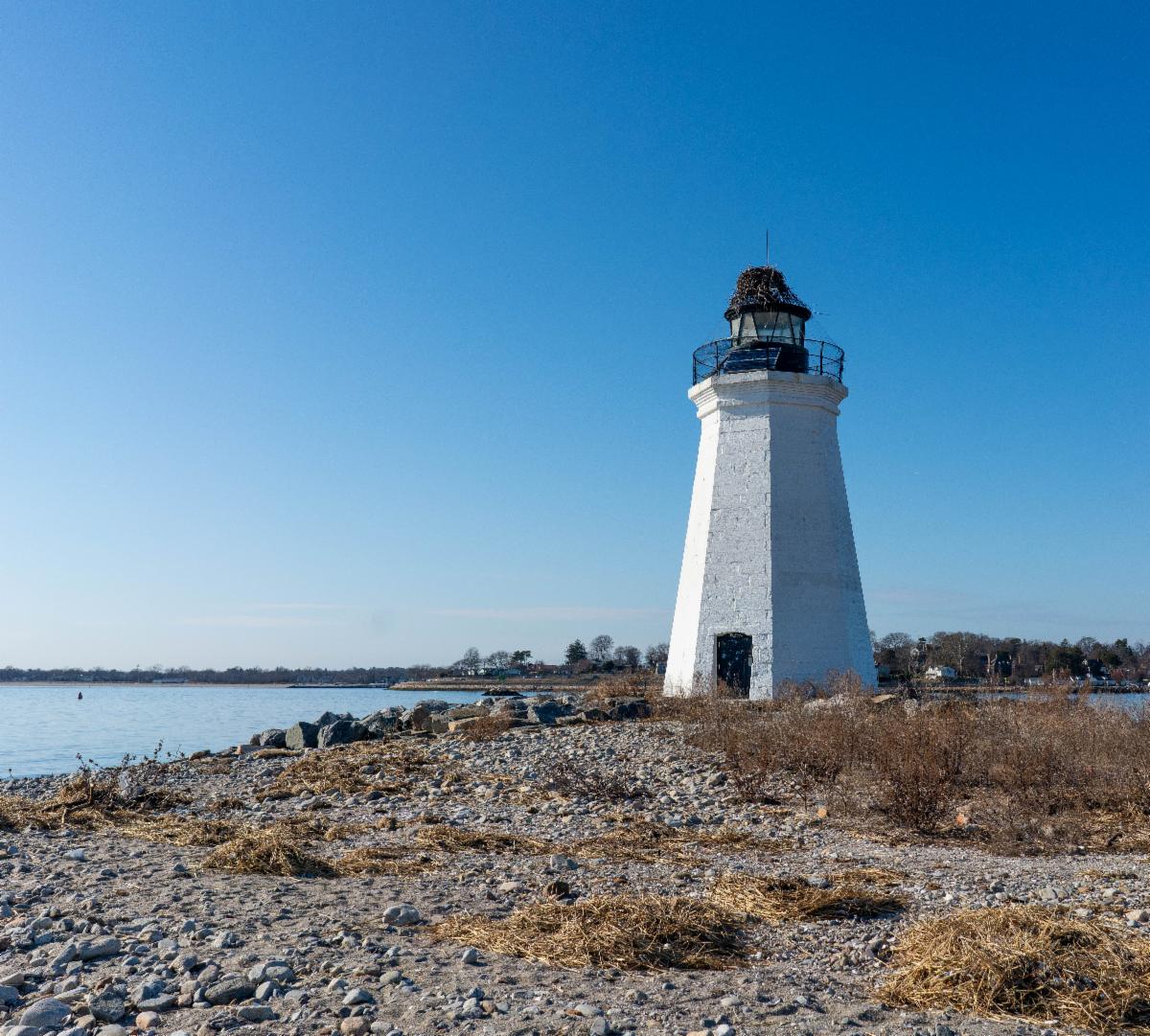
7. Fayerweather Island Light
This lighthouse is situated on Fayerweather Island in Bridgeport, which shelters Black Rock Harbor. For that reason, the light is sometimes referred to as Black Rock Harbor Light. A breakwater has connected the island to the mainland since 1917, when the island was much larger and used for sheep pasturing. The lighthouse was built in 1808 following the federal government’s purchase of the island a year prior. The first light, an octagonal wooden tower, was destroyed by a hurricane in 1821, and replaced in 1823 with a stone tower.
| |
The lighthouse was deactivated in 1932 after two offshore automatic lights were constructed. It was given to the City of Bridgeport in 1934 and became part of Seaside Park. In 1983, the lighthouse was restored by the Friends of Seaside Park, and the island was established as a nature preserve. Following vandalism, it was again restored in the 1990s and relit in 2000. The lighthouse is maintained by the Black Rock Community Council and received a major facelift thanks to their History Committee. The lighthouse can be seen from across Black Rock Harbor and from Seaside Park, where the island can be accessed by a moderate hike across the breakwater. Seaside Park has fees from Memorial Day weekend to Labor Day weekend. | |
|
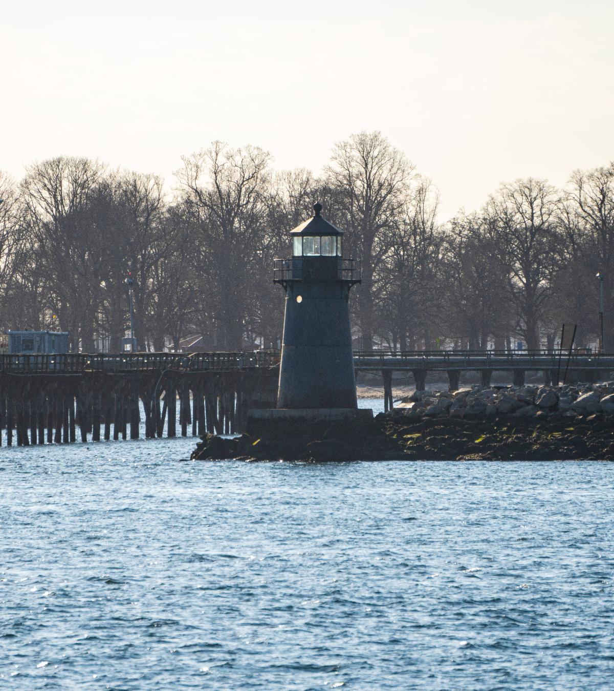
8. Tongue Point Light
Tongue Point Light in Bridgeport, also known as Bug Light, was originally built in 1891. It was moved in 1919 when the breakwater it was situated on was shortened to accommodate large vessels that struggled to make the turn into the harbor. It is an example of a prefabricated cast-iron lighthouse that was common in the late 1800s.
The lighthouse was automated in 1954 and remains an active aid to navigation thanks to the protests of local boaters and residents when the Coast Guard planned to deactivate and remove it in 1967. It is hard to get a good view of the lighthouse as the area around the light is on the restricted grounds of a power plant. It is best viewed by boat.
| |
Photo: Braden Lynn/DEEP LWRD | | |
|
|
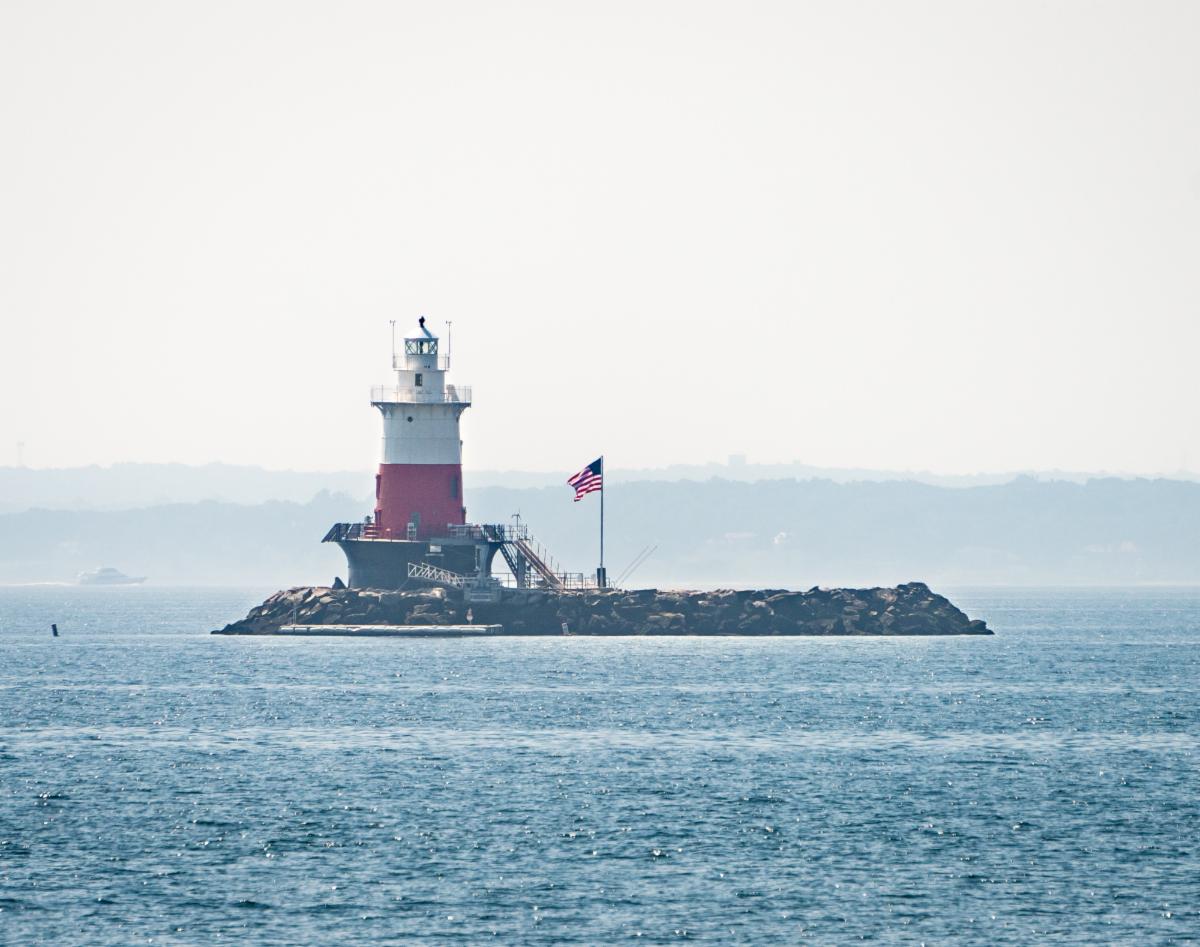
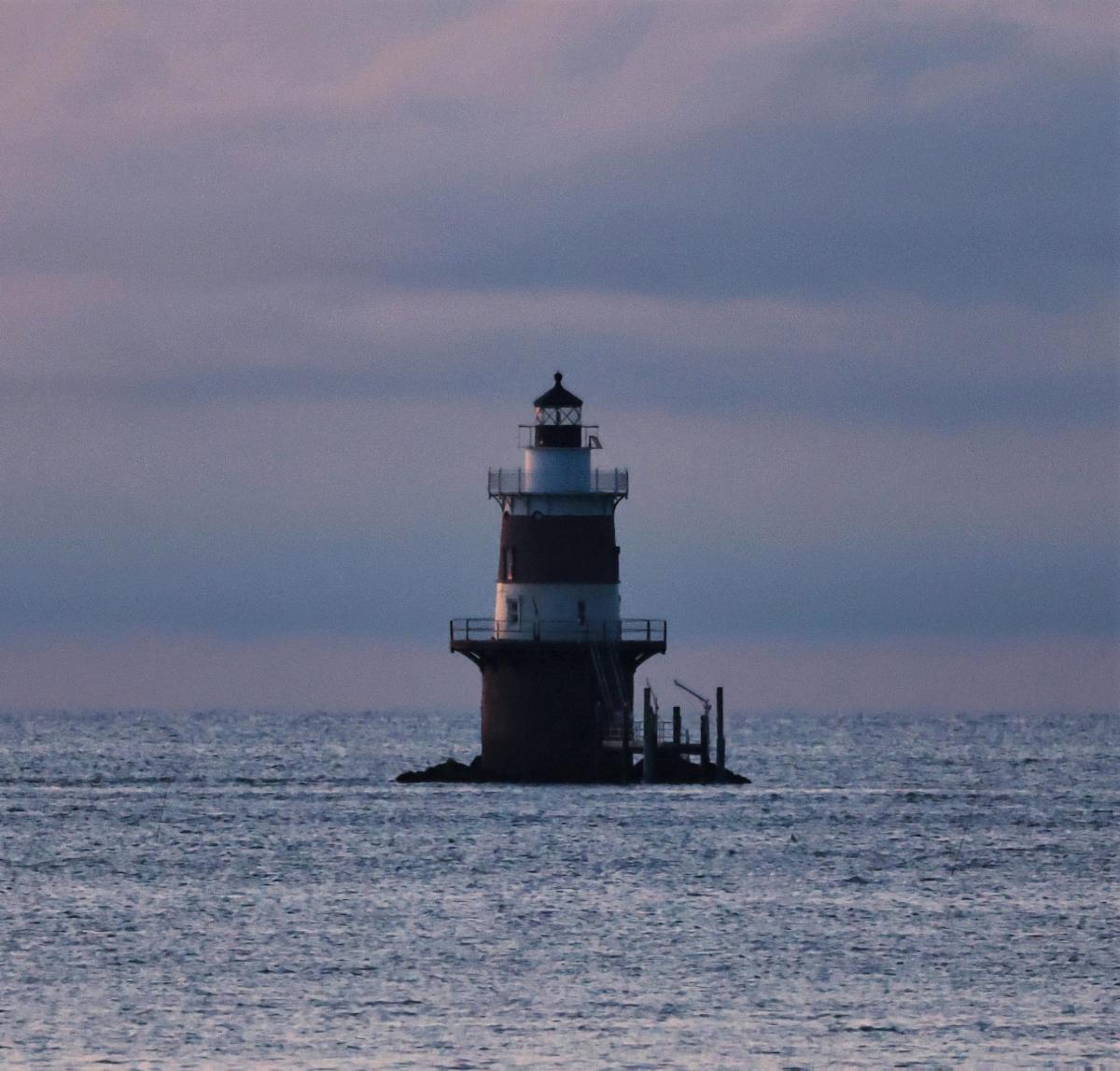
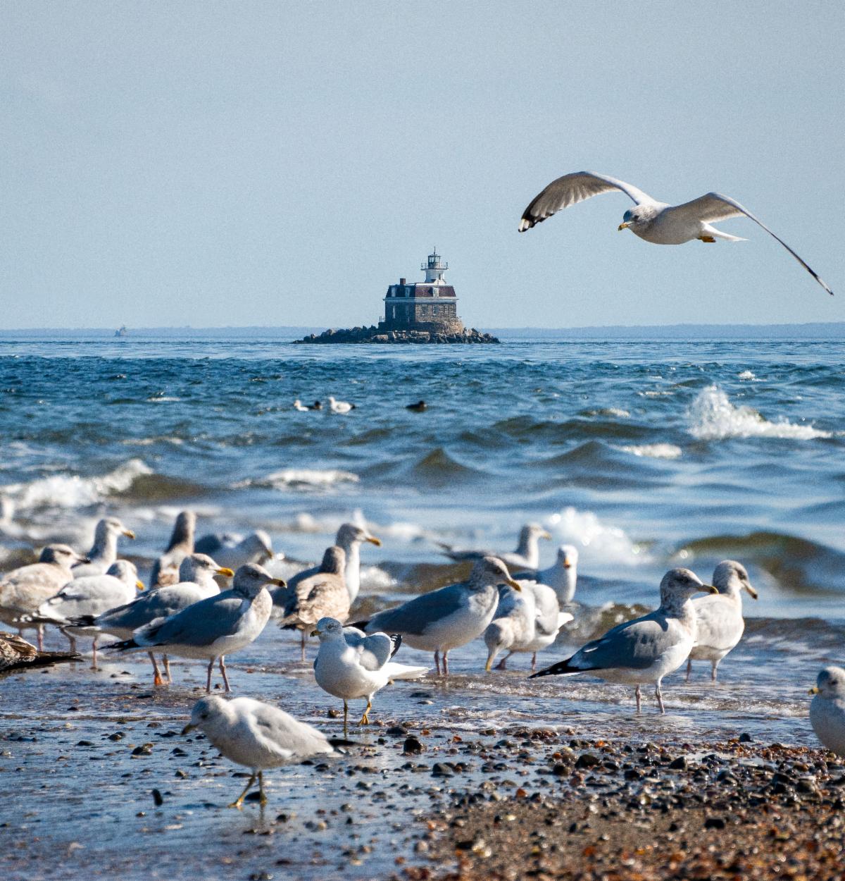
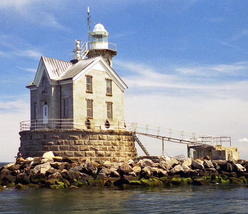
9. Stratford Shoal Light
This lighthouse is situated atop Stratford Shoal, a dangerous reef in Long Island Sound about midway between the shores of Connecticut and Long Island, earning the light its alternate name of Middle Ground Light. Various aids to navigation were deployed prior to the lighthouse including spar buoys and a lightship. The lightship was stationed at the southeast end of the shoal in 1938, but repeatedly lost its anchorage, once drifting 23 miles northeast before being found near Falkner Island.
| |
|
The lighthouse was completed in 1877 after numerous delays in construction caused by storms. It is a 35-foot granite structure built on a small, man-made island at the site of two former natural islands that eroded away. Similar to Penfield Reef Light, it was one of the last masonry lighthouses built before the use of sparkplug lighthouses. It was also the most isolated lighthouse in Connecticut, making it a difficult assignment for keepers, some of whom developed psychological problems.
The lighthouse was automated in 1970. In 2016, it was transferred to the Korstad Marine Preservation Society under the guidelines of the National Historic Lighthouse Preservation Act, but legal disputes over use and ownership of the land beneath the lighthouse led to it being returned and listed for auction in 2023. The light is best seen by private boat. It can also be seen distantly to the east from the Bridgeport to Port Jefferson Ferry.
| |
|
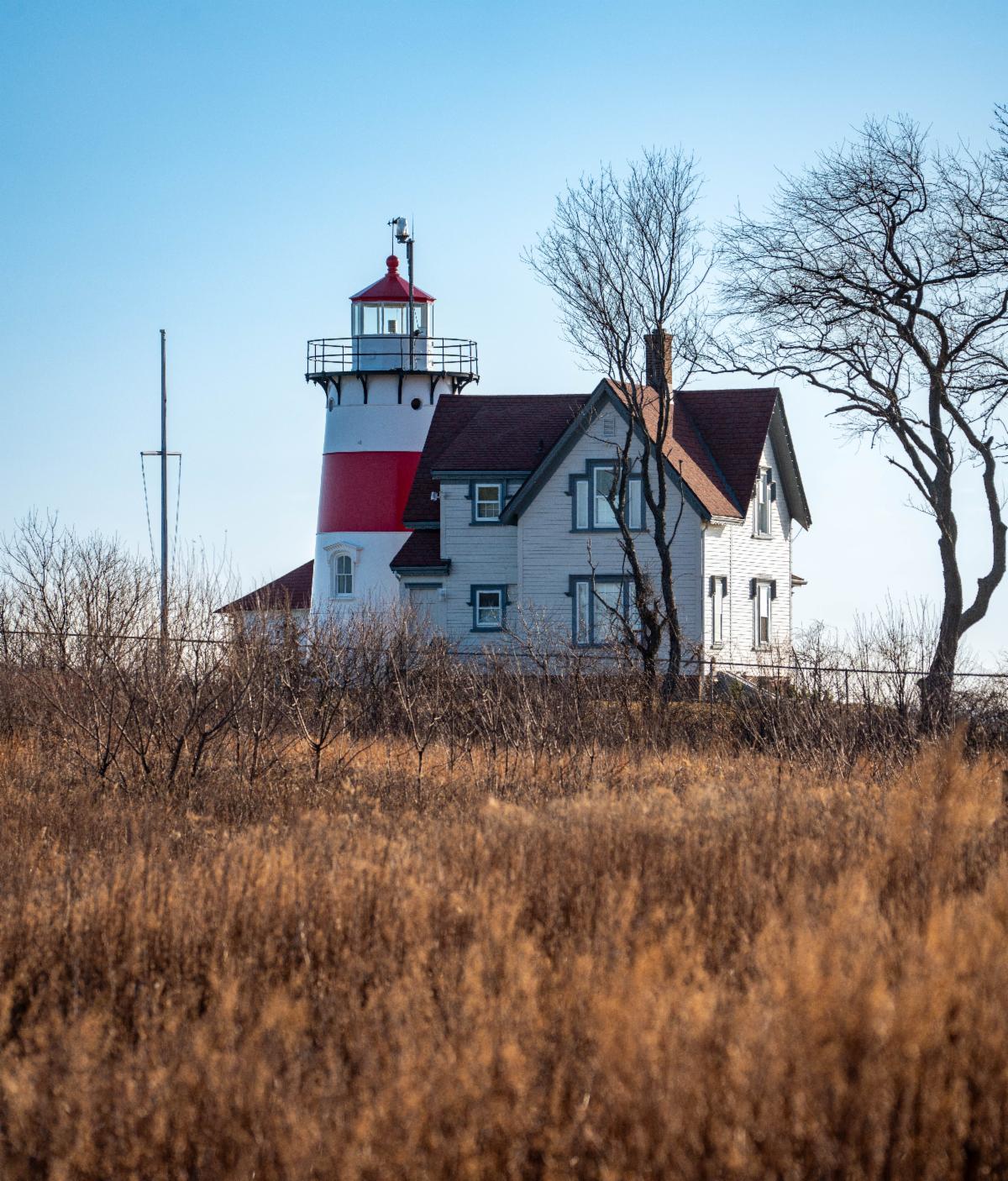
10. Stratford Point Light
The first lighthouse at Stratford Point was built in 1822. By 1867, the original tower was in disrepair and the keeper’s house was too small to accommodate two keepers. The authorities delayed rebuilding the light by appointing a married couple as keeper and assistant. The present light and keeper’s house was finally built in 1881.
Stratford Point is a frequently foggy and stormy location. One keeper, Theodore Judson, allegedly had to ring the fog bell for 104 consecutive hours during a February storm, which briefly let up before requiring another 103 consecutive hours of ringing.
| |
Photo: Braden Lynn/DEEP LWRD | |
|
Although Keeper Judson also made the extraordinary claim to a local newspaper that he had seen 12 to 15 mermaids frolicking in the waves off the point, a local steamboat captain stated that neither the light nor the fog signal had ever failed during Judson’s tenure, which supports the story of his nearly nine-day spell at the bell winding mechanism.
The lighthouse was automated in 1978 and still serves as an active aid to navigation. In 2019, the Town of Stratford entered a license agreement with the United States Coast Guard to provide public access at the site. The lighthouse and grounds were closed in 2023 for lead removal and remediation, but the Coast Guard hopes to have it ready for public viewing again soon. In the meantime, the lighthouse can be seen on weekdays from the Connecticut Audubon Society's adjacent wildlife refuge at Stratford Point.
| |
Photo: Braden Lynn/DEEP LWRD | |
|
11. Southwest Ledge Light
Completed in 1876 off New Haven Harbor, Southwest Ledge Light was one of the first lighthouses to be built on a cylindrical iron foundation. The lighthouse went into operation on January 1st of the following year. The design is unique, an eight-sided cast-iron structure lined with wood with empire detailing.
Before being installed at the site, the superstructure intended for the ledge was on display at the Centennial Exposition in Philadelphia in 1876, with a keeper maintaining a light in the tower during the expo. Delaware’s Ship John Shoal Light was planned as a twin lighthouse to Southwest Ledge Light, and when construction on the Southwest Ledge foundation unexpectedly finished first, the duplicate structure was sent there to expedite construction while the original structure was sent to Delaware after the expo.
| |
The lighthouse was automated in 1973 and remains an active aid to navigation. It is best seen from Lighthouse Point Park in New Haven or by boat. Lighthouse Point Park is subject to parking fees for non-New Haven residents from April 1st to November 1st. | |
|
12. Five Mile Point Light
Before there was a lighthouse at Five Mile Point, the site was notable for an attempted British invasion that was repelled by American riflemen during the American Revolution. The British later landed at the site and burned down the house of resident Amos Morris. He rebuilt his house, which still stands not far from the lighthouse. His son later sold the land for the lighthouse to the government, and a 30-foot wooden tower was constructed in 1805. Amos Morris Jr. also served as the light’s first keeper, though his service only lasted three weeks.
The current tower, an 80-foot octagonal brownstone tower, was built in 1847. The lighthouse was deactivated in 1877 after the completion of Southwest Ledge Light.
| |
Photo: Braden Lynn/DEEP LWRD | |
In 1922, the light was transferred to the State of Connecticut and later purchased by the City of New Haven. The New Haven Park Commission opened Lighthouse Point Park in 1924, with the city’s only public swimming beach at the time. The lighthouse was later renovated and cleaned in 1986. The light is easily visible throughout Lighthouse Point Park, which is open year-round (parking fees apply for non-New Haven residents from April 1st to November 1st.) | | |
|
|
13. Falkner Island Light
Falkner Island, also commonly spelled Faulkner’s Island, is located about three miles from the coast of Guilford. The lighthouse on the island was built in 1802 after being commissioned by President Thomas Jefferson in response to several incidents of vessels wrecking on the rocks around the island. A 40-foot octagonal stone octagonal tower, the light is Connecticut’s second oldest lighthouse.
| |
|
During the War of 1812, British troops stopped at Faulkner Island, but did no harm to the tower or its keeper as they realized the importance of the lighthouse to their own safety. A fire in 1976 destroyed the keeper’s house and scorched the tower. The light was repaired and automated two years later, and in 1988 the light was converted to solar power.
The bluffs that support the lighthouse had been eroding at a rate of at least six inches per year by the late 1900s, and the lighthouse stood only 35 feet from the edge by the time the Falkner’s Light Brigade, founded in 1991, was able to come to its rescue. Restoration work was done on the island to prevent further erosion, including a stone wall and a buffer zone, in the late 1990s and early 2000s, and further restoration on the tower and lantern was done in 2010.
The lighthouse and island are closed to the public to protect endangered roseate terns, as Falkner Island hosts the only nesting colony in the state and one of the largest on the east coast. The Faulkner’s Light Brigade plans to continue hosting an annual open house, which returned in 2023, for the public to explore the grounds and lighthouse for one day every September. The light is best viewed by boat, but the island can be seen very distantly from the shores of Guilford.
| |
|
14. Saybrook Breakwater Light
Also known as Saybrook Outer Light, this lighthouse was built in 1886 at the end of a breakwater where the Connecticut River meets Long Island Sound. It is a 49-foot cast-iron sparkplug-style tower, very similar to Stamford Harbor Ledge Light.
The lighthouse was hammered by the Hurricane of 1938, which swept away the bridge from the light to the breakwater, along with a platform around the lighthouse, a 12-foot rowboat, and two large kerosene tanks. The lighthouse keepers boarded up the engine room window, but waves smashed through and flooded the room. Keeper Sidney Gross disconnected the electric light and put the old incandescent oil vapor lamp to use, but the vibrations from the storm caused the lamp’s mantle to collapse. Keeper Gross stayed in the lantern room all night to keep the light going, but feared the lighthouse wouldn’t last the night. In the morning, he observed that everything except for the lighthouse tower had been swept away.
| |
Photo: Braden Lynn/DEEP LWRD | |
|
The lighthouse was automated in 1959, and the Coast Guard repainted the lighthouse in 1996 and removed a fuel tank and generator. The light continues to serve as a navigational aid. The lighthouse was auctioned twice before being purchased privately and being restored for private personal use by the owner.
Connecticut residents likely recognize the lighthouse as the iconic feature on the state’s popular “Preserve the Sound” license plates. The lighthouse is best viewed by boat, but can also be seen distantly by walking the road loop in Fenwick or from the Old Saybrook shoreline.
| |
Photo: Braden Lynn/DEEP LWRD | |
|
15. Lynde Point Light
The first light at Lynde Point was built in 1803, but mariners complained that it was too short and too dim. The tower was rebuilt in 1838 with a new 65-foot brownstone octagonal tower, similar to those built on Falkner Island and at Lighthouse Point in New London.
When Saybrook Breakwater Light was built in 1886, this light became commonly known as Saybrook Inner Light, with light on the breakwater often referred to as Saybrook Outer Light. The lighthouse was electrified in 1955 and automated in 1978.
| |
|
Not everyone enjoyed lighthouse life. Violet Horoschak, wife of one of the coastguardsmen stationed at the lighthouse, said in a 1976 Associated Press article: “Everyone says it must be great (to live next to the lighthouse). Let them try it. It’s so boring, there’s nothing to do. It’s a place to get fat, eat, and lie around and watch TV. Even my dog’s gained weight.”
In 2023, the Coast Guard determined the lighthouse exceeded their needs and began the search to find a new owner. The New London Maritime Society, which stewards three other lighthouses in the area, has applied to take ownership of the lighthouse and aims to provide public access to the light. As with Saybrook Breakwater, there is currently no public access to this lighthouse, and it can only be seen distantly from the road in Fenwick, the shores of Old Saybrook, or by boat.
| |
|
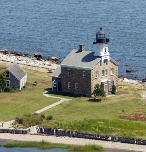
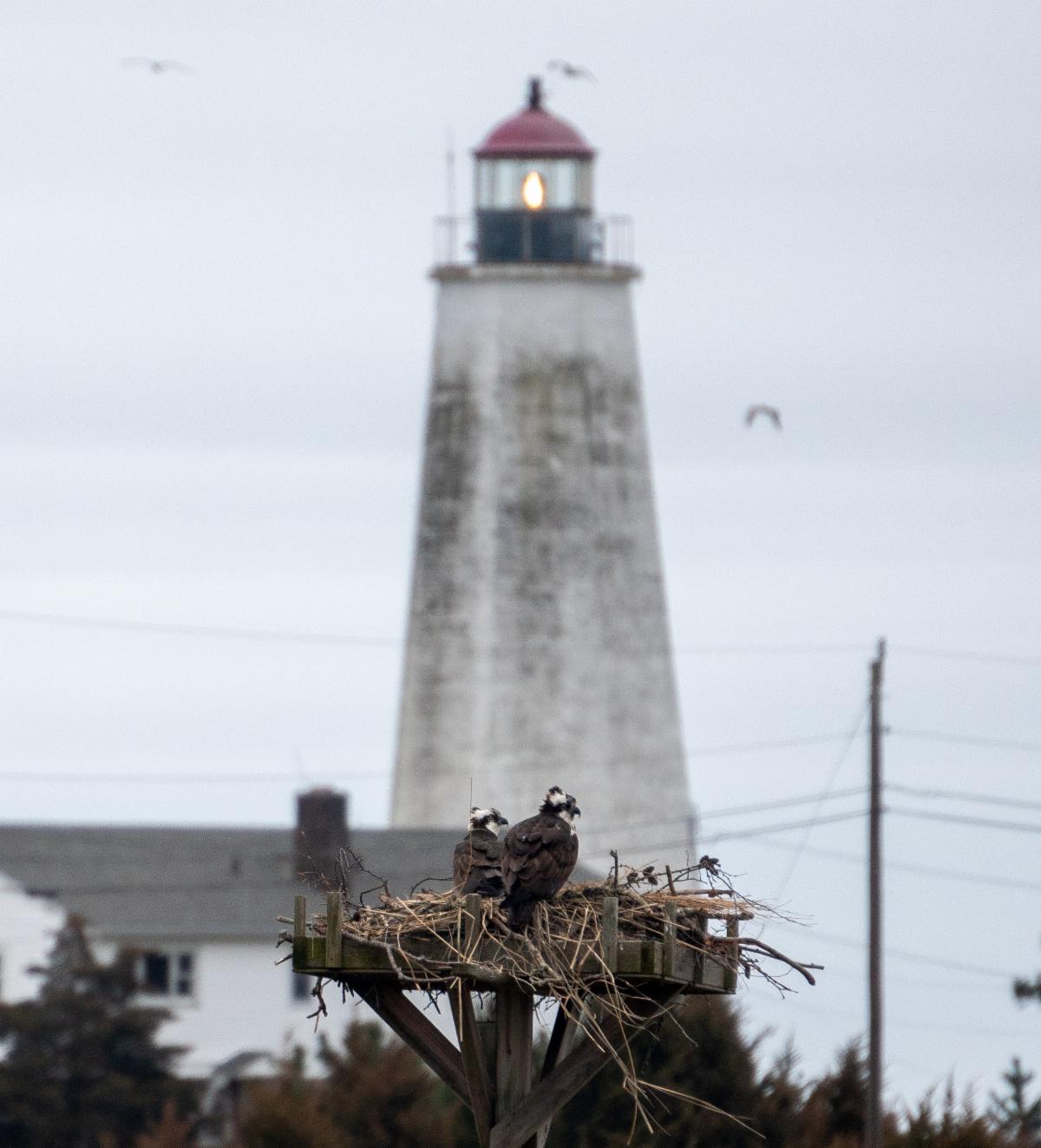
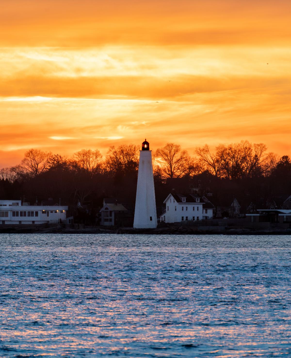
16. New London Harbor Light
The fourth lighthouse in North America and the first on Long Island Sound, New London Harbor Light was built in 1761 using money raised by selling lottery tickets. The first lighthouse survived the American Revolution unscathed. The original lighthouse was replaced with an 89-foot octagonal brownstone tower in 1801, which still stands today and is the oldest lighthouse in Connecticut.
A series of fog signals were installed at the light in the late 1800s. In 1904, a new siren was installed that angered local residents. After the Mayor of New London, along with 75 citizens, petitioned for its removal, a less objectionable trumpet replaced the siren. The fog signal was later relocated to New London Ledge Light in 1911.
| |
Photo: Braden Lynn/DEEP LWRD | |
|
Under the provisions of the National Historic Lighthouse Preservation Act, the lighthouse was transferred to the New London Maritime Society by 2009. The Maritime Society began giving guided tours of the lighthouse in 2012, and cleaned and restored the lighthouse in 2014. The following year, the Society was barred from holding tours by city order. A superior court judge later overturned the order in 2018, ruling that small-scale visits to the lighthouse by request were consistent with the lighthouse’s historic use, and the light reopened in 2019, provided that tours be limited to groups of no more than 6, no more than five times per day, and no more than 12 tours per week. Tours are currently offered by the Maritime Society in accordance with those guidelines.
According to the U.S. Coast Guard, from the top of New London Harbor Light, one can see more lighthouses than from any place on earth. The light can be seen from Pequot Ave in New London, as well as distantly across the harbor in Groton or by boat.
| |
Photo: Braden Lynn/DEEP LWRD | |
|
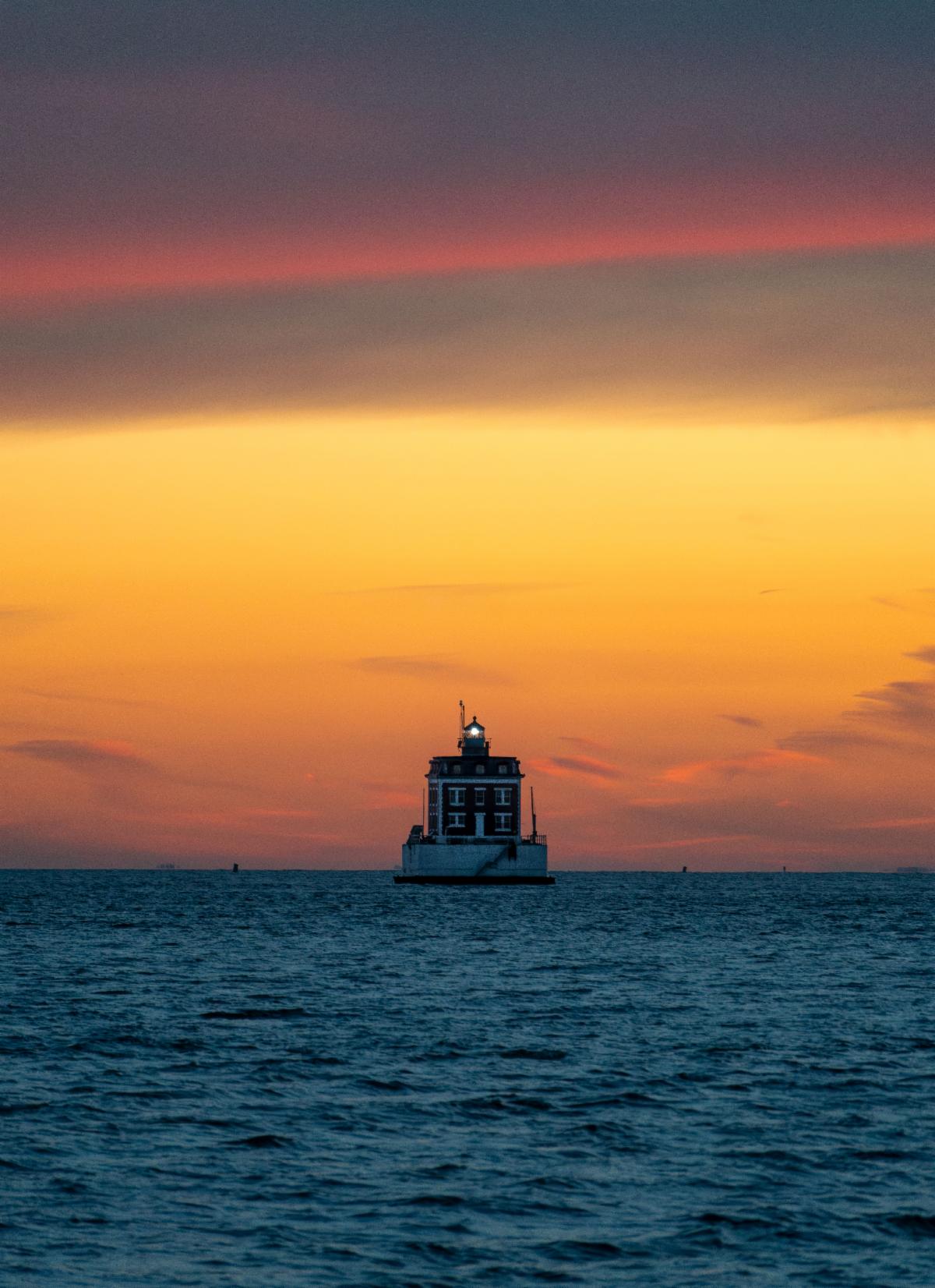
17. New London Ledge Light
This iconic lighthouse in New London Harbor was completed in 1909 and was one of the last lighthouses built in New England. Its unique design is a rare case of a 20th century lighthouse not constructed of cast iron. It was originally named Southwest Ledge Light, but was renamed to avoid confusion with the lighthouse of the same name in New Haven Harbor.
The light was crewed until 1987, when it became the last lighthouse on Long Island Sound to be automated. In 1988, the lighthouse was leased to New London Ledge Lighthouse Foundation. Project Oceanology started taking school children out to the light and continues its programs to this day. The light was restored by the Ledge Light Foundation, which established an interpretive center inside the lighthouse.
| |
In September 2015, it was announced that ownership of the lighthouse would be transferred to the New London Maritime Society under the guidelines of the National Historic Lighthouse Preservation Act. The Society offers guided tours of the lighthouse. The light is still an active aid to navigation. It can be seen distantly from the shores of Groton and New London, and easily by boat as it is a fixture of New London Harbor. | |
|
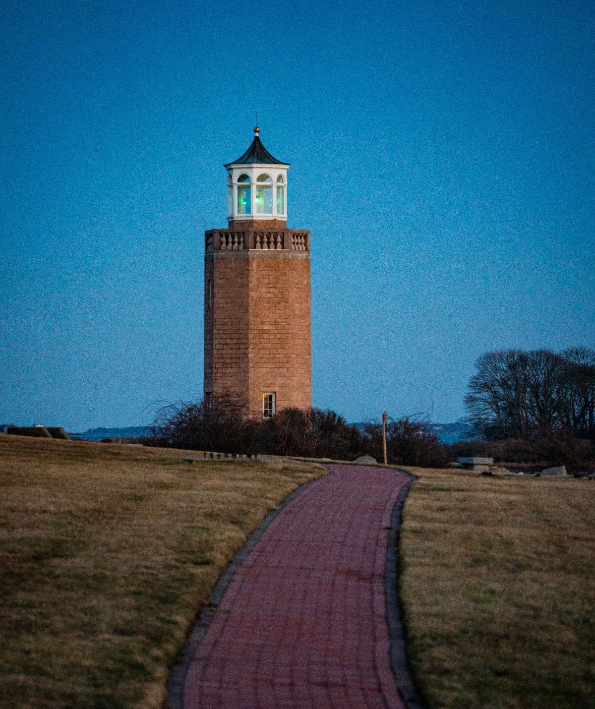
18. Avery Point Light
The last lighthouse to be built in Connecticut, Avery Point light in Groton was finished in 1943. It is a 41-foot octagonal concrete block tower. The lighthouse’s debut as a navigation aid was delayed by war concerns. It was lit for the first time on May 2, 1944 with an unusual array of eight 200-watt bulbs which illuminated a fixed white light.
The light served a purpose for Race Rock Light southwest of Fishers Island, NY. When the keepers could no longer see the light at Avery Point, they knew it was time to turn on the foghorn. The light was tended by personnel or students from the Coast Guard Training Station during its short time as an active aid to navigation.
| |
Photo: Braden Lynn/DEEP LWRD | |
|
The lighthouse was deactivated in 1967 when the Coast Guard relocated its training facility from Avery Point to Governor’s Island, NY. The property reverted to the State of Connecticut and became the Southeastern Campus of the University of Connecticut, later renamed University of Connecticut at Avery Point.
Fundraising for restoration began through the American Lighthouse Foundation (ALF) and the Avery Point Lighthouse Society (APLS) in 1999. By 2006, the tower was restored, and a new lantern was fabricated by the West Mystic Wooden Boat Building Company, owned by a former lighthouse keeper. The light was relit the same year as a private aid to navigation. The light can be seen from shore by walking along the public access path at UCONN Avery Point
| |
Photo: Braden Lynn/DEEP LWRD | |
|
19. Morgan Point Light
Morgan Point Light was first a 25-foot granite tower built in 1831. After complaints that the light was too dim in a period when the shipbuilding industry was growing, the current lighthouse was constructed and finished in 1868. The building is a two-story granite structure with a cast-iron tower, similar in style to Sheffield Island and Great Captain Island lights.
The lighthouse was deactivated in 1921 and sold privately. In 1991, it was again purchased by a private party who restored the lighthouse for personal use. The lighthouse is best seen by boat, as the grounds are private and the light is difficult to see from shore, although it is visible from Esker Point Beach and distantly from Groton Long Point. Some excursion tours in the area stop at the lighthouse.
| |
|
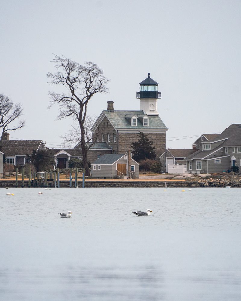
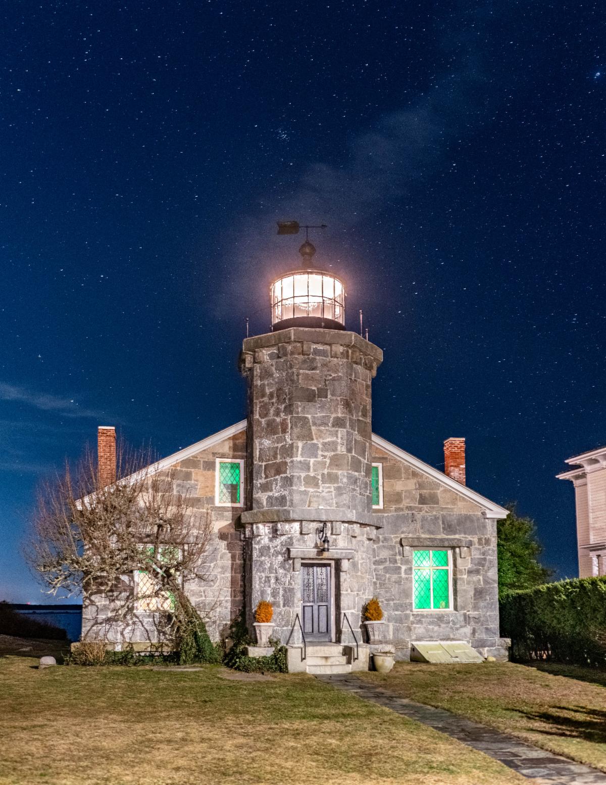
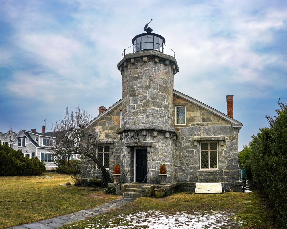
20. Stonington Harbor Light
The ship building industry in Stonington was booming in the early 1800s, and Stonington Harbor served as the base for the first ships involved in sealing in the Antarctic. In response to the increase in ship traffic to the harbor, Congress allocated funds for a lighthouse in 1822. Stonington Harbor Light was completed in 1823.
The first tower only lasted until the late 1830s, when quick beach erosion threatened the light. It was deconstructed and stones from the first tower were used to build a new stone tower and keeper’s house, characterized by a unique style that exemplifies the diversity in design of pre-Civil War lighthouses.
| |
Photo: Braden Lynn/DEEP LWRD | |
|
In 1889, a new lighthouse was built at the end of a recently constructed breakwater at the entrance to Stonington Harbor. Combined with the private light and fog signal that preceded the official lighthouse, the function of the original lighthouse was rendered obsolete. The keeper of Stonington Breakwater Light lived in the old lighthouse until a new house was built in 1908. The breakwater light was replaced by a skeleton tower in 1926.
The old lighthouse was acquired by the Stonington Historical Society in 1925. They converted the interior into the Old Lighthouse Museum, a six-room museum of local history, which continues to operate today. Currently, it is the only mainland lighthouse in Connecticut with an interior regularly open to the public. It can be accessed by a short walk from Stonington Point.
| |
|
SPOTLIGHTED COASTAL RESOURCE: The Public Trust Area
Connecticut has one of the highest coastal population densities in the nation, which has led to the development and private ownership of, and a shortage of public access to, most of our shoreline. One avenue that ensures the public has a protected right to shoreline access is the public trust area, which has been upheld across the world for centuries by the Public Trust Doctrine.
The Public Trust Doctrine, which grants the public rights to access the submerged lands of navigable waters, has origins dating back to Roman civil law under the reign of Emperor Justinian in the sixth century A.D., with roots as far back as the natural law of Greek philosophers in the second century. A section of Book II of the Institutes of Justinian remains the foundation of today’s Public Trust Doctrine:
“By the law of nature these things are common to all mankind – the air, running water, the sea, and consequently the shores of the sea. No one, therefore, is forbidden to approach the seashore, provided that he respects habitations, monuments, and the buildings, which are not, like the sea, subject only to the law of nations.”
English common law would adopt the Public Trust Doctrine from Roman civil law, recognizing the special nature of tidelands and navigable waters and giving them protection under the king’s name and ownership for all English subjects. This would later transfer to the American Colonies and be upheld by the Thirteen Colonies after the American Revolution. The Public Trust Doctrine continues to be one of the most important doctrines of property law in the United States.
While public trust lands are generally understood as the lands beneath tidal and navigable waters with the landward boundary being the mean high water line, there is some variation in how states interpret the public’s rights in these areas. For instance, our neighbor to the east, Rhode Island, gives the public a larger public trust area by allowing the public access rights up to 10 feet landward of the mean high tide line. Conversely, our neighbor to the north, Massachusetts, only recognizes the rights to fish, fowl (hunt birds), and navigate, including the movement, loading, and unloading of watercraft. Massachusetts courts have repeatedly made clear that the public does not have the right to stroll, sunbathe, or engage in recreation outside of fishing, fowling, and navigation on tidelands that are privately owned, as the state allows private property ownership up to the low tide line.
Here in Connecticut, the public trust area includes submerged lands and waters waterward of the mean high water line in tidal, coastal, or navigable waters of the state. This determination has been upheld through a number of state Supreme Court cases dating back to the earliest days of our nation. On land, the public trust area generally extends from the water up to a prominent water mark or debris line that indicates the mean high water line. The public trust area helps to alleviate the impacts of roadblocks to coastal public access. Connecticut residents have the right to fish, shellfish, boat, hunt, bathe, gather seaweed, and pass and repass freely in the public trust area, as private property in almost all cases ends at the mean high water line.
Activists have historically used the public trust area to bring attention to coastal access issues and educate the public on their rights in the public trust area. By the early 1970s, almost all of Connecticut's coastline was privately owned or restricted to town residents only, with the exception being a few miles of public beach at three state beaches. In an effort to bring attention to the lack of public access, activist Ned Coll famously used the public trust area to walk the entire length of the Connecticut coastline, which led to several confrontations with hostile property owners who attempted to deny him access to the shores adjacent to their land and in one case earned him a black eye. In another act to publicize privatization of Connecticut’s coast in 1974, Coll arranged for a parachutist carrying a banner reading "Free America's Beaches" to land in the water near the Madison Beach Club, as Coll and a group of 65 mothers, children, and volunteers hopped off three boats and came ashore. Coll triumphantly planted an American flag in the sand as the group enjoyed the public beach below the mean high water line.
As mentioned in the preceding article, Connecticut’s lighthouses are important feats of engineering and relics of our state's maritime history. However, they also provide examples of limited public access to Connecitcut's historic resources, especially for people eager to visit and photograph these scenic lighthouses. While the public trust area can be used to navigate around some of these land access issues, long stretches of private upland along the shore with no public access sites can obstruct the public from effectively using their rights to pass and recreate in the public trust area and to find closer views of the lighthouses. However, in cases where a nearby public access site gives residents a place to park and access the public trust area, a closer view of one of Connecticut's distinctive lighthouses that would be otherwise impossible to access from inland roads may be a short walk or paddle away. And in cases where municipalities, whether independently or through partnerships with the Coast Guard or non-profits, work to provide public access at or near a lighthouse, these sites become iconic destinations on our coast where people can come to enjoy both the historic value of the lights and the recreational opportunity to experience the vastness of Long Island Sound, which the Public Trust Doctrine preserves as belonging to everyone.
The DEEP Land and Water Resources Division is committed to preserving and expanding public access wherever possible, and realizing that goal becomes much easier when citizens, non-profits, and municipal officials are willing to come together to form a broad coalition and create change in the spirit of Ned Coll's lifelong fight for public access to our coastline. The greater the area accessible to the public, the more we can exercise our rights within the public trust area.
| |
|
SPOTLIGHTED PUBLIC ACCESS: Stonington Borough
The picturesque village of Stonington Borough has an atmosphere that is both unique and familiar. It has a quaint New England charm that is amplified by its small size. The bustle and traffic of many larger coastal communities isn't seen here—it's a bit slower, and a bit quieter, and yet possesses a rich history as one of the oldest communities in Connecticut.
Another quality that adds to the Borough's distinctive charm is its accessibility. There are multiple public access sites throughout the easily walkable downtown area. Various shops, art galleries, boutiques, restaurants, and museums lining Water Street provide visitors with plenty of activities to fill an afternoon. Visitors to the Borough may even recognize filming locations from various movies, including Mystic Pizza and Hope Springs. Of course, one of the biggest draws are the wonderful views provided from the coastal public access sites, and six sites listed on the Connecticut Coastal Access Guide are located in the Borough.
The Town Dock Fishing Pier and Memorial provides an access pier for fishing and an interpretive sign describing the village's maritime history. It is also a good place to view the sailboats that commonly race in the area or the active marine commercial fishing fleet in the harbor. A few streets over, Wayland's Wharf offers a gazebo with scenic views of the harbor, a short walk from the shops on Water Street.
At the end of Wall Street, the Dodge Paddock and Beal Preserves provide a variety of bird and wildlife viewing, crabbing, walking trails, and views of Sandy Point Island. Here, visitors can enjoy a leisurely walk to an upland meadow in the village's quiet corner. A little further up Water Street, visitors can stroll down the 800-foot waterfront path at the Stonington Commons public access site.
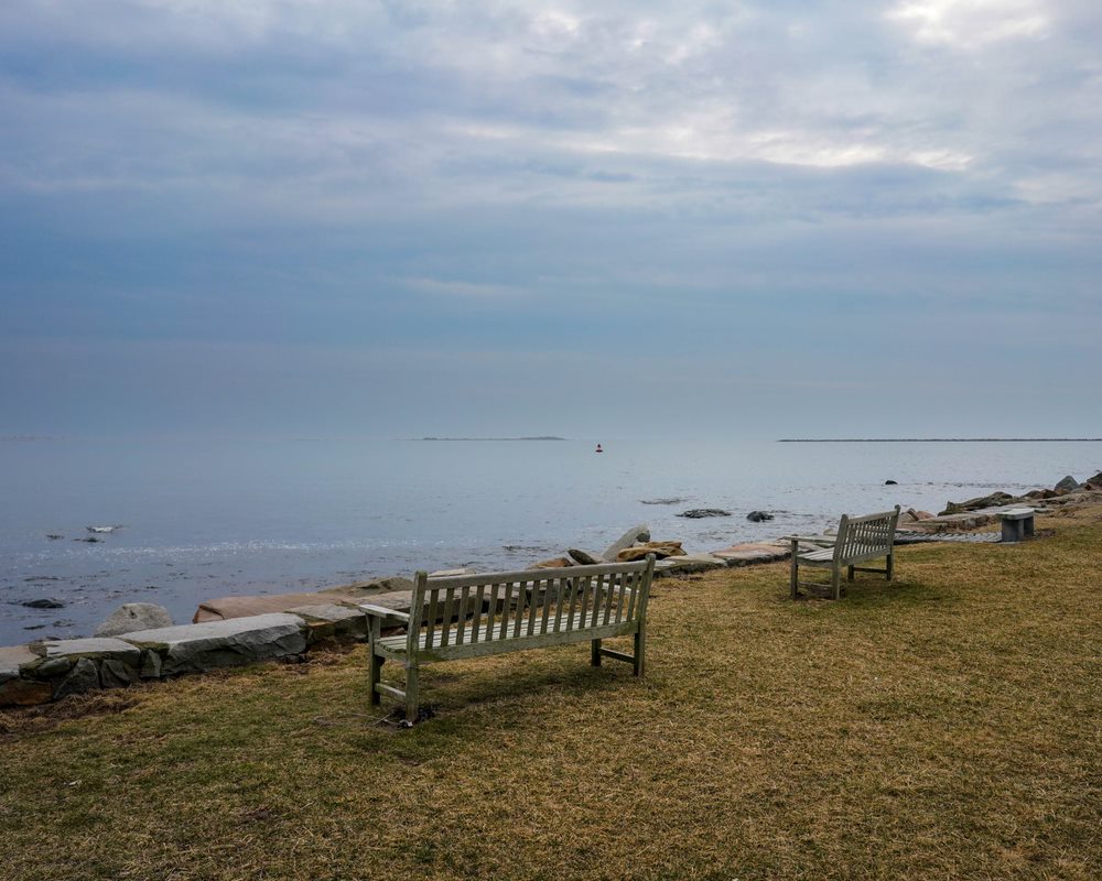
The last two sites are located at the end of Water Street. DuBois Beach is a family-oriented beach with a pavilion and clean sandy beach. From May through Labor Day, day passes or season passes are required. Outside of the summer season, it is free to access. The Stonington Point site offers panoramic views of Fisher's Island Sound, as well as benches and picnic tables and the nearby Old Lighthouse Museum. The museum is one of Stonington's most well-known landmarks and has been open to the public for almost a century. Visitors can explore fascinating exhibits filled with history and artifacts of Stonington's maritime heritage and climb the 29 circular steps and small ladder to the top of the tower. The Old Lighthouse Museum is open daily in July and August, and five days a week during the spring and fall hours, and on weekends from late October to mid-December. From Stonington Point, Watch Hill Lighthouse in Westerly, RI and Latimer Reef Light in Fishers Island Sound, NY are also visible.
Stonington Borough is a great place for a visit to a uniquely charming village that is steeped in a rich maritime history still evident today. Thanks to the various public access sites around the Borough, the village's small-town charm can be enjoyed by everyone, and it is an especially good choice for a visit if this issue of Sound Outlook has piqued your interest in learning more about Connecticut's lighthouses and experiencing one first hand, from the inside.
| |
Stonington Point and the Old Lighthouse Museum | |
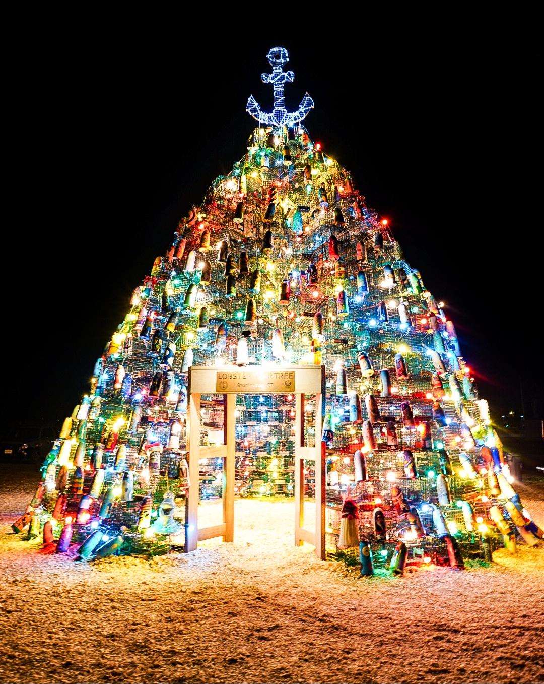
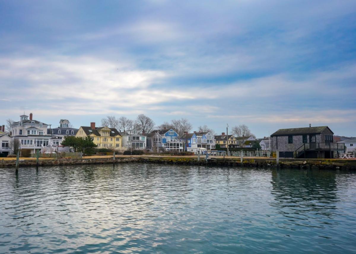
Left: the famous Lobster Trap Tree, on display near the Stonington Town Dock around the holidays every year. Right: colorful Stonington Borough as seen from the Wayland's Wharf public access | |
|
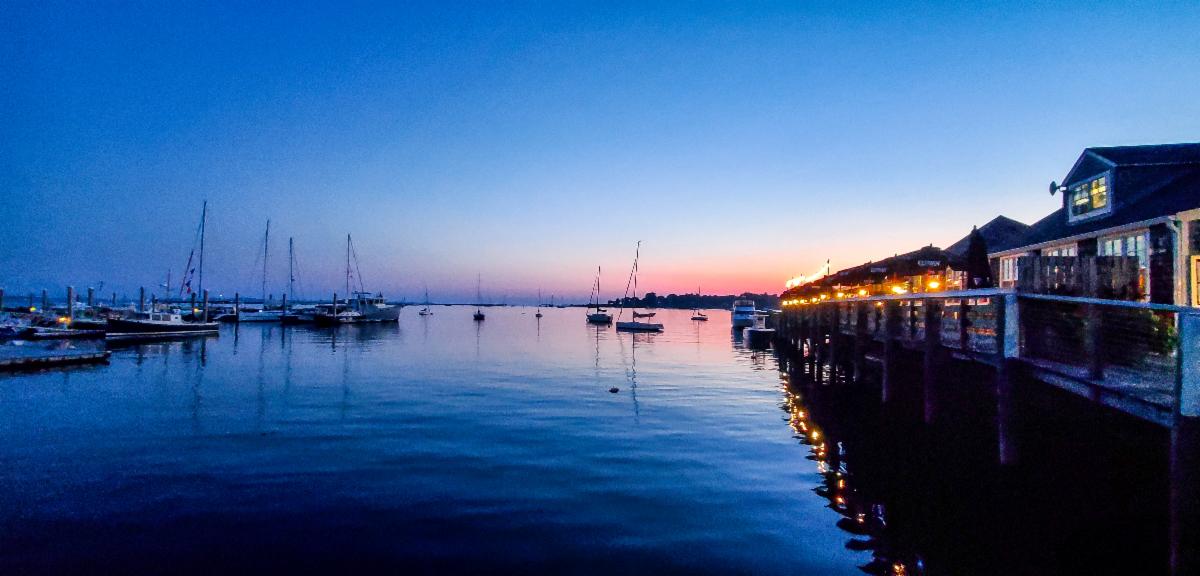
Sunset over Stonington Harbor from Stonington Borough
Photos: Braden Lynn/DEEP LWRD
| |
|
CLIMATE CHANGE UPDATE: DEEP to Allocate $2 Million to Address Tree Canopy Access in Connecticut
The Department of Energy and Environmental Protection announced the Urban Forest Equity Grant Program in January. The new program is designed to address the lack of tree canopy in disadvantaged communities using funding from the federal Inflation Reduction Act.
This grant program is available to state and local government entities, federally recognized tribes, and non-profit organizations. Individual grants up to $200,000 will be available, and funding is expected to be allocated over multiple grant rounds through 2026. Applications were accepted up to April 17, 2024.
“Trees and forests in our cities and towns play a key role in filtering our air and water, supporting wildlife, and building social cohesion within our communities,” said DEEP Commissioner Katie Dykes. “This new federal funding builds neighborhood-level climate resilience to impacts like hotter temperatures and flooding, and will provide new shade and benefits to our environment on streets and blocks that disproportionately lack access to tree cover.”
Urban trees provide many environmental and socioeconomic benefits to communities. Trees help infiltrate water and reduce soil eroision, lower air temperatures with shade, reduce wind speeds and noise pollution, create wildlife habitat, and provide colors, character, and enhance community economies by making city streets more attractive to visitors and businesses.
Previously, several coastal communities have been awarded grants for urban forestry grants through the Urban and Community Forestry, Equity through Capacity Building, and Urban Forestry Climate Change Grant Programs. These grants have been awarded to create urban forest management plans, tree inventories, tree plantings, and educational programs in New Haven, West Haven, Bridgeport, Milford, Stratford, Fairfield, New London, Groton, Norwalk, and Greenwich, as well as other inland communities in the state.
The Urban Forest Equity Grant Program is geared towards projects that demonstrate clear benefits to disadvantaged communities as defined in the Climate and Economic Justice Screening Tool, and there is no match requirement for this grant program.
| |
|
FIRST IMPRESSIONS: Kevin O'Brien, Connecticut National Estuarine Research Reserve
This column features the "First Impression" that set someone on their path to environmentalism. We hope Sound Outlook readers will relate to these "First Impressions" and recall their own experiences that led them to appreciate and care about Long Island Sound.
Kevin O’Brien is the former supervisor of the Technical Resources section here at LWRD. His experience with DEEP started as a Coastal Fellow with NOAA in 1999, and soon after he became a full-time employee with the former Office of Long Island Sound Programs (now LWRD). In 2023, he announced he would be leaving LWRD to manage the Connecticut National Estuarine Research Reserve (NERR), a partnership of UCONN, NOAA, and DEEP which he helped designate in January of 2022.
Kevin grew up far from the coast in Torrington, CT, but each summer his family would rent a cottage in Old Lyme and enjoy a vacation on the beach. His father, who was in the Naval reserve, would explain the ebb and flow of the tides and how they interact with the coast as they played on the beach.
That was the formative stage of my awareness of a particular environment, what it supports, what it does, and how it’s something we want to be outside to enjoy.
While he remembers spending a lot of his childhood playing outside and being involved with sports, his family wasn’t particularly outdoorsy or more environmentally focused than others, so Kevin remembers these family vacations along the Connecticut shoreline as his First Impression, where his environmental awareness began to take root.
Kevin began college as a math major and was fairly sure he wanted to continue pursuing mathematics in the consulting world until his senior year, during which he took a few elective classes. One of the classes that appealed to him was Oceanography, which ended up being his First Step towards shifting his career focus to the environmental field.
After taking that class, I decided I didn’t really want to be in a corporate environment, I really wanted to find something that incorporated oceanography and ocean science. So, I spent part of my senior year looking at what kind of grad schools I could apply to, and I was really intrigued by the blend of marine science and policy that was called "marine affairs" at the time.
Kevin considered several schools that offered Marine Affairs degrees, eventually landing at the University of Miami, where the influences of the people he learned from and worked with would begin his Behavior Change towards greater environmental awareness.
As part of being in grad school, being around like-minded scientists and researchers in the marine and social science fields, who all had a strong focus in the ocean environment, conservation, our coexistence with the ecosystem, and managing resources was a big eye opener, and every other role that I’ve been in since then has travelled in those circles.
While he was in gradate school, his capstone project led him to the NOAA Coastal Services Center in Charleston, SC, where he worked with NOAA scientists and researchers as well as South Carolina Sea Grant. He took note of how, while working in a different state with a different set of players than he had in Florida, the values, thought processes, and concepts of the environmental field remained the same.
It became really easy to be aware of the concepts you’re looking at and how, even if you’re in a different place, the concepts remain the same. While the resource in one place may be different than another, it still needs to be balanced. You can’t exploit it, otherwise it won’t be around.
During graduate school, he worked as a teaching assistant at a marine science magnet school before graduating and continuing to work as a NOAA Coastal Fellow, which brought him back to Connecticut. Despite his love for life in the south and Charleston in particular, he accepted the two-year fellowship in Connecticut working on dredged material management.
After the fellowship was over, he accepted a position at DEEP and worked in OLISP for a year before an opportunity came up in the consulting world. At that point in his career, he was very focused on GIS work, and the consulting position allowed him to try something new while continuing full-time GIS work. However, he quickly realized that the private sector wasnot something he was interested in long-term.
As time progressed, I came to realize that the projects I was working on were great projects and had value to a lot of people and could help in a lot of ways, but it wasn’t topically as interesting to me as working in coastal management or environmental protection. So, during that phase I was actually thinking about how I could transition back into the environmental field, because that’s when I realized that was what I wanted to do.
Kevin quickly took his Big Step and made a full-time return to DEEP and the world of coastal management. He accepted a position in 2004 as an Environmental Analyst and returned to the exact same cube and desk that he had left. The projects that he was working on started as mostly GIS focused but have evolved to encompass a broader range of aspects of coastal management.
He became the supervisor of the Technical Resources section in 2018. He also collaborated on a project to establish the Connecticut National Estuarine Research Reserve, which was in the process of site selection for the proposed Reserve at the time that Kevin became a supervisor. He was heavily involved in the process of designating the Reserve, which is part of a larger network of 30 coastal sites designated to protect and study estuarine systems. The slow, involved process of establishing the Reserve gave him a lot of knowledge that made him the ideal candidate to manage the project.
I was really able to understand the big picture, what the Reserve system nationally does and seeks to achieve, and also how the Connecticut Reserve was structured to address not only the large national issues, but also the issues that were important here Connecticut. It just seemed like it was a really interesting opportunity.
The position was a natural fit for Kevin, and something he says involves the same blend of marine science and policy that initially attracted him to the field of marine science in the first place, as well as continuing to work on the shores of Connecticut that provided him with his first environmental impression in his childhood.
While we in LWRD were sad to see him go, we are happy he gets to pursue his passion, and we know there is nobody more qualified to manage the Connecticut NERR. He said it was a very difficult decision to leave, but he felt comfortable doing so with the confidence that the LWRD team would continue to do great work, some of it in collaboration with the Connecticut NERR, and had some uplifting parting words for his DEEP colleagues:
I have been so fortunate at basically any and every step along the way to have worked with and for amazing and committed people, and I’ve been able to learn so much from working in and among those groups and individuals. It’s really important to have great people that are dedicated to what they do, and that’s when you can make big strides and big changes.
| | |
|
|
Published by the Department of Energy and Environmental Protection, Bureau of Water Protection and Land Reuse.
Editors: Braden Lynn, Mary-beth Hart
Layout: Caryn Furbush; Illustrations: Tom Ouellette
Resources:
The Field Guide to Lighthouses of the New England Coast by Elinor De Wire
New England Lighthouses: A Virtual Guide
Lighthouse Friends
Connecticut Coastal Access Guide
Putting the Public Trust Doctrine to Work - NOAA
The Connecticut Department of Energy and Environmental Protection is an Affirmative Action/Equal Opportunity Employer that is committed to complying with the requirements of the Americans with Disabilities Act. If you are seeking a communication aid or service, have limited proficiency in English, wish to file an ADA or Title VI discrimination complaint, or require some other accommodation, including equipment to facilitate virtual participation, please contact the DEEP Office of Diversity and Equity at 860-418-5910 or by email at deep.accommodations@ct.gov. Any person needing an accommodation for hearing impairment may call the State of Connecticut relay number - 711. In order to facilitate efforts to provide an accommodation, please request all accommodations as soon as possible following notice of any agency hearing, meeting, program or event.
| | |
CONNECTICUT DEPARTMENT OF ENERGY AND ENVIRONMENTAL PROTECTION
| |
| | | |